

Sea Island, British Columbia
Encyclopedia
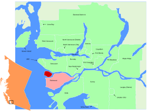
Richmond, British Columbia
Richmond is a coastal city, incorporated in the Canadian province of British Columbia. Part of Metro Vancouver, its neighbouring communities are Vancouver and Burnaby to the north, New Westminster to the east, and Delta to the south, while the Strait of Georgia forms its western border...
, directly across the river from Vancouver
Vancouver
Vancouver is a coastal seaport city on the mainland of British Columbia, Canada. It is the hub of Greater Vancouver, which, with over 2.3 million residents, is the third most populous metropolitan area in the country,...
and fifteen kilometres from Vancouver's downtown core. The island is in the estuary
Estuary
An estuary is a partly enclosed coastal body of water with one or more rivers or streams flowing into it, and with a free connection to the open sea....
of the Fraser River
Fraser River
The Fraser River is the longest river within British Columbia, Canada, rising at Fraser Pass near Mount Robson in the Rocky Mountains and flowing for , into the Strait of Georgia at the city of Vancouver. It is the tenth longest river in Canada...
, giving it a unique ecological environment. Sea Island is the home to Vancouver International Airport
Vancouver International Airport
Vancouver International Airport is located on Sea Island in Richmond, British Columbia, Canada, about from Downtown Vancouver. In 2010 it was the second busiest airport in Canada by aircraft movements and passengers , behind Toronto Pearson International Airport, with non-stop flights daily to...
(YVR) and a large conservation project to offset the environmental impact the airport causes; including a wildlife preserve and public beaches. The population of the island, many of whom live in the neighbourhood
Neighbourhood
A neighbourhood or neighborhood is a geographically localised community within a larger city, town or suburb. Neighbourhoods are often social communities with considerable face-to-face interaction among members. "Researchers have not agreed on an exact definition...
of Burkeville
Burkeville, British Columbia
Burkeville, British Columbia is a village located beside Russ Baker Way on Sea Island. It was constructed in 1943 by the federal government of Canada. The street names have an aeronautical theme, many of which bear the names of airplane manufacturers. It also served to provide housing for workers...
, was 736 persons as of the 2001 census
Canada 2001 Census
The Canada 2001 Census was a detailed enumeration of the Canadian population. Census day was May 15, 2001. On that day, Statistics Canada attempted to count every person in Canada. The total population count of Canada was 30,007,094. This was a 4% increase over 1996 Census of 28,846,761. In...
. It is Statistics Canada
Statistics Canada
Statistics Canada is the Canadian federal government agency commissioned with producing statistics to help better understand Canada, its population, resources, economy, society, and culture. Its headquarters is in Ottawa....
's Census Tract
Census tract
A census tract, census area, or census district is a geographic region defined for the purpose of taking a census. Usually these coincide with the limits of cities, towns or other administrative areas and several tracts commonly exist within a county...
0150.00 of the Vancouver CMA.
Vancouver International Airport
The airport first opened for service on Sea Island in 1931, and began servicing commercial flights in 1937. The airport received relatively light traffic for the next fifty years until extensive growth in international traffic, primarily between the United StatesUnited States
The United States of America is a federal constitutional republic comprising fifty states and a federal district...
and Asia
Asia
Asia is the world's largest and most populous continent, located primarily in the eastern and northern hemispheres. It covers 8.7% of the Earth's total surface area and with approximately 3.879 billion people, it hosts 60% of the world's current human population...
, necessitated expansion of service. With investments from the airlines, the Canadian government
Government of Canada
The Government of Canada, formally Her Majesty's Government, is the system whereby the federation of Canada is administered by a common authority; in Canadian English, the term can mean either the collective set of institutions or specifically the Queen-in-Council...
and a surcharge on tickets for improvement costs
Airport Improvement Fee
An Airport Improvement Fee or Embarkation Fee or Airport Tax or Service charge or Service fee is an additional fee charged to departing and connecting passengers at an airport. It is levied by government or an airport management corporation and the proceeds are usually intended for funding of major...
, the airport began a significant overhaul in the 1990s.
The airport is now the second largest in Canada
Canada
Canada is a North American country consisting of ten provinces and three territories. Located in the northern part of the continent, it extends from the Atlantic Ocean in the east to the Pacific Ocean in the west, and northward into the Arctic Ocean...
, with over 16 million passengers passing through each year. It has grown to three passenger terminals and three main runways servicing over forty airlines.
Land transportation
Grant McConachie WayGrant McConachie Way
Grant McConachie Way is a three-to-six lane expressway in Richmond and Vancouver, British Columbia, Canada. Named for aviator Grant McConachie, it is the primary access road into Vancouver International Airport on Sea Island. It is also one of the three roads entering Vancouver from the south,...
is the road leading to the main airport terminal, while Russ Baker Way connects Vancouver and the main part of Richmond via the Arthur Laing Bridge
Arthur Laing Bridge
The Arthur Laing Bridge is a four-lane, high-level bridge carrying Grant McConachie Way over the North Arm of the Fraser River between Vancouver and Richmond, British Columbia's Sea Island where the Vancouver International Airport is located. Two parallel independent unpainted steel box girders...
, No. 2 Road Bridge
No. 2 Road Bridge
The No. 2 Road Bridge is a low-level four-lane bridge in Richmond, British Columbia, Canada. It connects Sea Island, where the Vancouver International Airport is located, to the west part of Richmond on Lulu Island...
, Dinsmore Bridge
Dinsmore Bridge
Dinsmore Bridge is a bridge in Richmond, British Columbia, Canada. Built in 1969, it connects Sea Island to Lulu Island, the main island of the city. It is an extension of Gilbert Road on Lulu Island; on Sea Island, it meets up with Russ Baker Way...
, Moray Bridge
Moray Bridge
Moray Bridge, originally christened 'The Middle-arm Swing Bridge' in October 1957, is a low-level one-way swing bridge in Richmond, British Columbia, Canada...
and the Sea Island Bridge
Sea Island Bridge
Sea Island Connector is a low-level three-lane one-way bridge in Richmond, British Columbia, Canada. It connects Bridgeport Road on Lulu Island with Grant McConachie Way on Sea Island, where the Vancouver International Airport is located. It handles traffic heading into Sea Island...
. Sea Island is also served by the Canada Line
Canada Line
Canada Line is a rapid transit line in the Metro Vancouver region of British Columbia, Canada. Opened in August 2009, it is the third line in TransLink's SkyTrain metro network, servicing Vancouver, Richmond, and the Vancouver International Airport...
, part of the SkyTrain
SkyTrain (Vancouver)
SkyTrain is a light rapid transit system in Metro Vancouver, British Columbia, Canada. SkyTrain has of track and uses fully automated trains on grade-separated tracks, running mostly on elevated guideways, which helps SkyTrain to hold consistently high on-time reliability...
rapid transit network, which connects the airport to Downtown Vancouver and Downtown Richmond.
Airport vicinity
Since the construction of the airport, efforts have been made by the Canadian Wildlife ServiceCanadian Wildlife Service
The Canadian Wildlife Service or CWS is a branch of the Department of the Environment, also known as Environment Canada, a department of the Government of Canada....
to preserve the sensitive environment of the island. The land is subject to changes caused by both its natural estuary and human impact. With the expansion of the airport during the 1990s and through 2000, care for the environment has matched the airport's growth.
Around the airport, birds are the primary concern as an aviation hazard to the planes. The island is a hub in the Pacific Skyway migration pattern. Wildlife officers patrol the grounds to keep track of migration patterns of birds and to control their chances of interfering with an aircraft.
The British Columbia Institute of Technology
British Columbia Institute of Technology
The British Columbia Institute of Technology , is a public, coeducational, academic institution of higher education in Burnaby, British Columbia, Canada. The polytechnic has five campuses located in the Metro Vancouver region, with the main campus in Burnaby...
has completed constructing of a new aviation-oriented location near Cessna Drive and Russ Baker Way.
There is a Canadian Coast Guard
Canadian Coast Guard
The Canadian Coast Guard is the coast guard of Canada. It is a federal agency responsible for providing maritime search and rescue , aids to navigation, marine pollution response, marine radio, and icebreaking...
station near the southwest end of the island. Access to that area of the island is restricted.
A small historic community called Burkeville is situated on the island, located near Miller Road and Russ Baker Way.
Sea Island Conservation Area
The conservation area makes up 1.4 square kilometres in the north end of Sea Island. The preserve is out of the flight routes for the airport, so the goal of the wildlife service is to shift animal populations to the area. It is not open to the public, and is patrolled by the Canadian Wildlife Service.Sturgeon Bank Wildlife Management Area
Over 50 square kilometres in area, Sturgeon Bank is a marine preserve located off the west side of the island and is made up of intertidal and subtidal waters. Boating is prohibited in the area.Beaches
Sea Island boasts two public beaches, McDonald Beach Park and Iona Beach Regional Park.McDonald Beach is operated by the city of Richmond
Richmond, British Columbia
Richmond is a coastal city, incorporated in the Canadian province of British Columbia. Part of Metro Vancouver, its neighbouring communities are Vancouver and Burnaby to the north, New Westminster to the east, and Delta to the south, while the Strait of Georgia forms its western border...
. It is a recreational facility, with picnic areas and boat docking available. The park is located on the northern end of the island, making it accessible from up-river as well as the west bank of the mainland.
Iona Beach is operated by the Greater Vancouver Regional District
Greater Vancouver Regional District
Metro Vancouver is the brand name of the board of the inter-municipal administrative body known as the Greater Vancouver Regional District , a regional district in British Columbia, Canada...
, and serves a more natural rather than recreational purpose. It features information on the flora and fauna, as well as a walking trail that culminates in a 1.5 kilometer jetty
Jetty
A jetty is any of a variety of structures used in river, dock, and maritime works that are generally carried out in pairs from river banks, or in continuation of river channels at their outlets into deep water; or out into docks, and outside their entrances; or for forming basins along the...
out into the Sturgeon Bank. (See also: Iona Island, British Columbia
Iona Island, British Columbia
Iona Island in Richmond, British Columbia, Canada was formerly an island, but is now a peninsula physically connected to Sea Island via a causeway...
.)
See also
- Vancouver International AirportVancouver International AirportVancouver International Airport is located on Sea Island in Richmond, British Columbia, Canada, about from Downtown Vancouver. In 2010 it was the second busiest airport in Canada by aircraft movements and passengers , behind Toronto Pearson International Airport, with non-stop flights daily to...
- 98 B-Line98 B-LineThe 98 B-Line was a bus rapid transit line in Metro Vancouver, British Columbia, Canada. It connected Richmond, British Columbia to Downtown Vancouver, with a connection to Vancouver International Airport. It travelled mainly along Granville Street in Vancouver and No. 3 Road in Richmond. It was...
(no longer in operation) - Canada LineCanada LineCanada Line is a rapid transit line in the Metro Vancouver region of British Columbia, Canada. Opened in August 2009, it is the third line in TransLink's SkyTrain metro network, servicing Vancouver, Richmond, and the Vancouver International Airport...
- Airport StationAirport Station (TransLink)Airport Station was a major public transit exchange point in Richmond, British Columbia, Canada. It is part of the TransLink system in Metro Vancouver. It was closed on September 7th, 2009, two and a half weeks after the opening of the Canada Line....
- Iona Island, British ColumbiaIona Island, British ColumbiaIona Island in Richmond, British Columbia, Canada was formerly an island, but is now a peninsula physically connected to Sea Island via a causeway...
- Lulu IslandLulu IslandLulu Island is the name of the largest island in the estuary of the Fraser River. The island makes up most of the City of Richmond, a major suburb of Vancouver, British Columbia...