

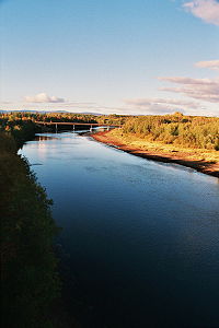
Nechako River
Encyclopedia
Nechako Plateau
The Nechako Plateau is the northernmost subdivision of the Interior Plateau, one of the main geographic regions of the Canadian province of British Columbia...
east of the Kitimat Ranges
Kitimat Ranges
The Kitimat Ranges are one of the three main subdivisions of the Coast Mountains in British Columbia, Canada, the other being the Pacific Ranges to the south and the Boundary Ranges to the north...
of the Coast Mountains
Coast Mountains
The Coast Mountains are a major mountain range, in the Pacific Coast Ranges, of western North America, extending from southwestern Yukon through the Alaska Panhandle and virtually all of the Coast of British Columbia. They are so-named because of their proximity to the sea coast, and are often...
of British Columbia
British Columbia
British Columbia is the westernmost of Canada's provinces and is known for its natural beauty, as reflected in its Latin motto, Splendor sine occasu . Its name was chosen by Queen Victoria in 1858...
and flows north toward Fort Fraser, then east to Prince George
Prince George, British Columbia
Prince George, with a population of 71,030 , is the largest city in northern British Columbia, Canada, and is known as "BC's Northern Capital"...
where it enters the Fraser River
Fraser River
The Fraser River is the longest river within British Columbia, Canada, rising at Fraser Pass near Mount Robson in the Rocky Mountains and flowing for , into the Strait of Georgia at the city of Vancouver. It is the tenth longest river in Canada...
. "Nechako" is an anglicization of [netʃa koh], its name in the indigenous Carrier language which means "big river".
Its main tributaries are the Stuart River
Stuart River
The Stuart River is a river in northeastern British Columbia, Canada. The river flows over from Stuart Lake to its junction with the Nechako River. The river drains a portion of the Nechako Plateau — a gently-rolling region characterized by small lakes and tributaries...
, which enters about 45 km (28 mi) east of Vanderhoof; the Endako; the Chilako, which enters about 15 km (9 mi) west of Prince George; and the Nautley River
Nautley River
Nautley River drains Fraser Lake into the Nechako River in the Central Interior of British Columbia, Canada.Only 800m in length, it is the shortest river in the province and one of the shortest rivers in the world, along with Powell River, the Wannock River at Rivers Inlet, and the Little River...
, a short stream from Fraser Lake. Among the other tributaries is the Cheslatta River, which drains Cheslatta Lake and enters the Nechako at the foot of the Nechako Canyon
Nechako Canyon
The Nechako Canyon, also known as the Grand Canyon of the Nechako, is a canyon on the Nechako River in the Central Interior of British Columbia, Canada, located between Cheslatta Falls and Knewstubb Lake, which lies immediately above the Kenny Dam, which forms the Nechako Reservoir...
via Cheslatta Falls and begins at the Kenny Dam and forms the Nechako Reservoir
Nechako Reservoir
The Nechako Reservoir, sometimes called the Ootsa Lake Reservoir, is a hydroelectric reservoir in British Columbia, Canada that was formed by a diversion of the Nechako River through the Kitimat Ranges of the Coast Mountains to sea level at Kemano to provide power for the aluminum smelter at Kitimat...
.
History
The expedition of Alexander MacKenzie went past the mouth of the Nechako in 1793, curiously, without observing it.The first European to ascend the Nechako was James McDougall
James McDougall (explorer)
James McDougall was a nineteenth century fur trader and explorer, who is remembered for his participation in opening up present-day British Columbia, Canada to European settlement as part of a North West Company expedition to the region, led by Simon Fraser....
, a member of Simon Fraser
Simon Fraser (explorer)
Simon Fraser was a fur trader and an explorer who charted much of what is now the Canadian province of British Columbia. Fraser was employed by the Montreal-based North West Company. By 1805, he had been put in charge of all the company's operations west of the Rocky Mountains...
's expedition, in 1806.
Nechako Reservoir
The Nechako is one of the main tributaries of the Fraser River, although most of its flow has been diverted through the Coast MountainsCoast Mountains
The Coast Mountains are a major mountain range, in the Pacific Coast Ranges, of western North America, extending from southwestern Yukon through the Alaska Panhandle and virtually all of the Coast of British Columbia. They are so-named because of their proximity to the sea coast, and are often...
to the Kemano generating station at sea level on the Gardner Canal
Gardner Canal
The Gardner Canal is one of the principal inlets of the British Columbia Coast. Technically a side-inlet of the larger Douglas Channel, the Gardner is still 90 km in length in its own right; total length of the waterways converging on the Douglas Channel is 320 km making it one of the...
, 858 m (2,815 ft) below the reservoir's intakes, which supplies power to the aluminum smelter at nearby Kitimat
Kitimat, British Columbia
Kitimat is a coastal city in northwestern British Columbia, in the Regional District of Kitimat-Stikine. The Kitimat Valley, which includes the adjacent community of Terrace, is the most populous urban district in Northwest British Columbia...
. The main reservoir of the Nechako power diversion is named the Nechako Reservoir
Nechako Reservoir
The Nechako Reservoir, sometimes called the Ootsa Lake Reservoir, is a hydroelectric reservoir in British Columbia, Canada that was formed by a diversion of the Nechako River through the Kitimat Ranges of the Coast Mountains to sea level at Kemano to provide power for the aluminum smelter at Kitimat...
or Ootsa Lake Reservoir, but there are many subnames for different parts of the lake as its conversion into a reservoir involved the amalgamation of chains of lakes, the largest of which were Eutsuk Lake and Natalkuz Lake, which form the south arm of the reservoir. The reservoir's alternate name comes from Ootsa Lake, now merged into the north arm of the reservoir but which was not on the course of the Nechako River. Other lakes also merged into the north arm are Whitesail Lake and Tahtsa Lake, with the correspondingly-named rivers connecting them re-dubbed Whitesail Reach and Tahtsa Reach. In between the two arms of the reservoir is the Quanchus Range
Quanchus Range
The Quanchus Range is a subrange of the Nechako Plateau in the Interior of British Columbia, Canada, located on the north end of Tweedsmuir North Provincial Park and Protected Area. It is almost completely an island after the creation of the Nechako Reservoir. Its two main summits are Michel Peak ...
.
The damming of the Nechako in 1952 and the consequent massive reduction in flow has been the source of considerable political controversy. The Cheslatta people (a subgroup of the Dakelh
Dakelh
The Dakelh or Carrier are the indigenous people of a large portion of the Central Interior of British Columbia, Canada.Most Carrier call themselves Dakelh, meaning "people who go around by boat"...
or Carrier) were flooded out by the creation of the reservoir and forced to abandon their homes with only two weeks' warning. The increase in water temperature caused by the reduction in flow has been an ongoing problem for the salmon run on the Fraser
Fraser River
The Fraser River is the longest river within British Columbia, Canada, rising at Fraser Pass near Mount Robson in the Rocky Mountains and flowing for , into the Strait of Georgia at the city of Vancouver. It is the tenth longest river in Canada...
and Stuart River
Stuart River
The Stuart River is a river in northeastern British Columbia, Canada. The river flows over from Stuart Lake to its junction with the Nechako River. The river drains a portion of the Nechako Plateau — a gently-rolling region characterized by small lakes and tributaries...
s as well as the Nechako.
External links
- Fraser Watershed entry
- BC Lakes and Rivers
- "Engineers Invade Another Wilderness - Huge Canadian Power Project Marks 20th Century Frontier Boom" , by Richard Neuberger detailed 1951 Popular Science article on the Kemano Hydro Project