

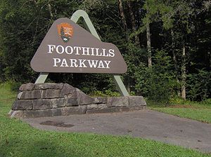
Foothills Parkway
Encyclopedia
National parkway
National Parkway is a designation for a protected area in the United States. The designation is given to a scenic roadway and a protected corridor of surrounding parkland. National Parkways often connect cultural or historic sites.-See also:...
which, if completed, will traverse the foothills of the northern Great Smoky Mountains
Great Smoky Mountains
The Great Smoky Mountains are a mountain range rising along the Tennessee–North Carolina border in the southeastern United States. They are a subrange of the Appalachian Mountains, and form part of the Blue Ridge Physiographic Province. The range is sometimes called the Smoky Mountains or the...
in East Tennessee
Tennessee
Tennessee is a U.S. state located in the Southeastern United States. It has a population of 6,346,105, making it the nation's 17th-largest state by population, and covers , making it the 36th-largest by total land area...
, located in the Southeastern United States. The 71-mile (114 km) parkway will ideally connect U.S. Route 129
U.S. Route 129
U.S. Route 129 is an offshoot route of U.S. Route 29, which it intersects near Athens, Georgia. US 129 currently runs for 582 miles from Knoxville, Tennessee, to Chiefland, Florida, at U.S. Route 19 and U.S. Route 98. It passes through the states of Tennessee, North Carolina, Georgia and Florida...
along the Little Tennessee River
Little Tennessee River
The Little Tennessee River is a tributary of the Tennessee River, approximately 135 miles long, in the Appalachian Mountains in the southeastern United States.-Geography:...
in the west with Interstate 40
Interstate 40
Interstate 40 is the third-longest major east–west Interstate Highway in the United States, after I-90 and I-80. Its western end is at Interstate 15 in Barstow, California; its eastern end is at a concurrency of U.S. Route 117 and North Carolina Highway 132 in Wilmington, North Carolina...
along the Pigeon River
Pigeon River (Tennessee - North Carolina)
The Pigeon River of western North Carolina and east Tennessee rises above Canton, North Carolina. Below this, it flows roughly parallel to Interstate 40 for many miles and is impounded by a dam -- Walters Dam -- belonging to Progress Energy before entering Tennessee, where it flows into the French...
in the east, passing through parts of Blount County
Blount County, Tennessee
Blount County is a U.S. county located in the U.S. state of Tennessee. Its population was 123,010 at the United States Census, 2010. The county seat is at Maryville, which is also the county's largest city....
, Sevier County
Sevier County, Tennessee
Sevier County is a county of the state of Tennessee, United States. Its population was 71,170 at the 2000 United States Census. It is included in the Sevierville, Tennessee, Micropolitan Statistical Area, which is included in the Knoxville-Sevierville-La Follette, TN Combined Statistical Area. The...
, and Cocke County. Large sections of the parkway will cross a series of high ridges running roughly parallel to the Tennessee boundary of the Great Smoky Mountains National Park
Great Smoky Mountains National Park
Great Smoky Mountains National Park is a United States National Park and UNESCO World Heritage Site that straddles the ridgeline of the Great Smoky Mountains, part of the Blue Ridge Mountains, which are a division of the larger Appalachian Mountain chain. The border between Tennessee and North...
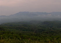
, and will offer unobstructed views of the Great Smokies to the south and the Tennessee Valley
Tennessee Valley
The Tennessee Valley is the drainage basin of the Tennessee River and is largely within the U.S. state of Tennessee. It stretches from southwest Kentucky to northwest Georgia and from northeast Mississippi to the mountains of Virginia and North Carolina...
to the north.
The oldest unfinished highway project in Tennessee, the Foothills Parkway project has been continuously stalled by funding difficulties since Congress authorized its construction in 1944. As of 2010, only 1/3 of the parkway had been completed and opened to vehicular traffic. The longest open section consists of a 16.5 miles (26.6 km) leg traversing the western flank of Chilhowee Mountain
Chilhowee Mountain
Chilhowee Mountain is a low ridge at the outer edge of the Great Smoky Mountains that stretches between the Little Tennessee River to the west and the Little Pigeon River watershed to the east...
in Blount County, connecting US-129 along the Chilhowee Lake impoundment
Chilhowee Dam
Chilhowee Dam is a hydroelectric dam located in Blount and Monroe counties, Tennessee, between river mile 33 and 34 on the Little Tennessee River. Construction began in 1955 and was completed in 1957. The dam's reservoir covers approximately at normal full pool and has a drainage area of . The...
of the Little Tennessee River with U.S. Route 321
U.S. Route 321
U.S. Route 321 is a spur of U.S. Route 21. It runs for 526 miles from South Carolina to Tennessee. The northern terminus of U.S. 321 is between Lenoir City and Oak Ridge, Tennessee, at Interstate 40 exit 364, which is about 4 miles west of Interstate 40's junction with Interstate 75...
in the town of Walland
Walland, Tennessee
Walland is an unincorporated community in Blount County, Tennessee, in the Southeastern United States. Walland is the site of a post office and is the place name associated with zip code 37886, which covers an area beyond the Walland community...
. The other open section is a 6 miles (9.7 km) stretch traversing Green Mountain in Cocke County, connecting US-321 in Cosby
Cosby, Tennessee
Cosby is an unincorporated community in Cocke County, Tennessee, United States. Although it is not a census-designated place, the ZIP Code Tabulation Area for the ZIP Code that serves Cosby had a population of 5,201 as of the 2000 U.S. Census...
with Interstate 40 in the Pigeon River valley. The Gatlinburg Bypass, which traverses the eastern flank of Cove Mountain between Pigeon Forge
Pigeon Forge, Tennessee
Pigeon Forge is a mountain resort city in Sevier County, Tennessee, located in the southeastern United States. As of the 2010 census, the city had a total population of 5,875....
and the national park, is also considered part of the parkway.
The parkway is managed by the National Park Service
National Park Service
The National Park Service is the U.S. federal agency that manages all national parks, many national monuments, and other conservation and historical properties with various title designations...
as part of Great Smoky Mountains National Park, and is not a separate unit of the national park system.
The Foothills of the Great Smoky Mountains
Tennessee River
The Tennessee River is the largest tributary of the Ohio River. It is approximately 652 miles long and is located in the southeastern United States in the Tennessee Valley. The river was once popularly known as the Cherokee River, among other names...
and French Broad River
French Broad River
The French Broad River flows from near the village of Rosman in Transylvania County, North Carolina, into the state of Tennessee. Its confluence with the Holston River at Knoxville is the beginning of the Tennessee River....
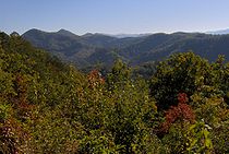
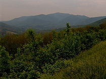
valleys to the north. The most prominent of the Foothills are characterized by long-but-narrow ridges, running parallel to the crest of the Smokies, similar to a circuit wall surrounding a medieval castle.
Although the average elevation of the Foothills is relatively low, a high topographic prominence
Topographic prominence
In topography, prominence, also known as autonomous height, relative height, shoulder drop , or prime factor , categorizes the height of the mountain's or hill's summit by the elevation between it and the lowest contour line encircling it and no higher summit...
is not uncommon among these ridges, due to their detachment from the main crest of the Smokies. English Mountain (3,629 ft), one of the highest of the Foothills, is the fifth most prominent mountain in Tennessee, and dominates the view south of Interstate 40 for a considerable stretch between Sevierville
Sevierville, Tennessee
Sevierville is a city in Sevier County, Tennessee, located in the Southeastern United States. Its population was 11,757 at the 2000 United States Census; in 2004 the estimated population was 14,101. Sevierville is the county seat of Sevier County, Tennessee....
and Newport
Newport, Tennessee
Newport is a city in Cocke County, Tennessee, United States. The population was 7,242 at the 2000 census. It is the county seat of Cocke County.-Geography:...
. Chilhowee Mountain, located mostly in Blount County, is the first major geological structure visible when approaching the mountains via Lamar Alexander Parkway (US-321), and its eastern flank, known as "The Three Sisters," is visible from almost anywhere in Maryville
Maryville, Tennessee
Maryville is the county seat of Blount County, Tennessee, in the Southeastern United States. The city is located south of Knoxville. Maryville's population was 27,258 at the 2010 census. It is included in the Knoxville Metropolitan Area. Maryville has received a number of accolades for its...
.
Geologically, the Foothills largely consist of Cambrian
Cambrian
The Cambrian is the first geological period of the Paleozoic Era, lasting from Mya ; it is succeeded by the Ordovician. Its subdivisions, and indeed its base, are somewhat in flux. The period was established by Adam Sedgwick, who named it after Cambria, the Latin name for Wales, where Britain's...
Class III rocks of the Paleozoic
Paleozoic
The Paleozoic era is the earliest of three geologic eras of the Phanerozoic eon, spanning from roughly...
period, a type known specifically as the Chilhowee Group. Chilhowee Group rocks, which are mostly sandstones, siltstones, and shales, range in age from about 300 million to 500 million years old. Thus, the rocks of the Foothills are much younger than the billion-year old Precambrian
Precambrian
The Precambrian is the name which describes the large span of time in Earth's history before the current Phanerozoic Eon, and is a Supereon divided into several eons of the geologic time scale...
Ocoee Supergroup rocks that form the crest and higher ridges of the Great Smokies range.
The most prominent of the Foothills include:
Little Pigeon River (Tennessee)
The Little Pigeon River is a river located entirely within Sevier County, Tennessee.It rises from a series of streams which flow together on the dividing ridge between the states of Tennessee and North Carolina inside the boundary of the Great Smoky Mountains National Park. The river is subdivided...
valley to the east. While the mountain is 35 miles (56.3 km) long, it rarely reaches a width of more than 3 or 4 miles (6.4 km). Little River
Little River (Tennessee)
Little River is a scenic river in Tennessee which drains a area containing some of the most spectacular scenery in the southeastern United States. The first of the river are all located within the borders of the Great Smoky Mountains National Park...
cuts a large gap in the middle of the mountain (near Walland
Walland, Tennessee
Walland is an unincorporated community in Blount County, Tennessee, in the Southeastern United States. Walland is the site of a post office and is the place name associated with zip code 37886, which covers an area beyond the Walland community...
), dividing it into eastern and western sections. The highest point on eastern section is 2,843 feet (866m) and the highest point on the western section is 2,650 feet (807m) at a knob known as Look Rock. 35.73047°N 83.81993°W
Bates Mountain — a low, bulky ridge between Miller Cove
Walland, Tennessee
Walland is an unincorporated community in Blount County, Tennessee, in the Southeastern United States. Walland is the site of a post office and is the place name associated with zip code 37886, which covers an area beyond the Walland community...
and Tuckaleechee Cove. Bates' highest point is just over 1700 feet (518.2 m). Although Bates lacks the dramatic "backbone" formation of Chilhowee, a rocky gorge on its south flank cut by Carr Creek has presented numerous construction challenges for the parkway project. 35.7227°N 83.75161°W
Cove Mountain — a large ridge situated between Wears Valley
Wears Valley, Tennessee
Wears Valley is an unincorporated area in Sevier County, Tennessee, treated by the U.S. Census Bureau as a census county division. As of the 2000 Census, the population of Wears Valley was 6,486....
to the west, Gatlinburg
Gatlinburg, Tennessee
Gatlinburg is a mountain resort city in Sevier County, Tennessee, United States. As of the 2000 U.S. Census, Gatlinburg had a population of 3,828. The city is a popular vacation resort, as it rests on the border of the Great Smoky Mountains National Park along U.S...
to the east, and Pigeon Forge
Pigeon Forge, Tennessee
Pigeon Forge is a mountain resort city in Sevier County, Tennessee, located in the southeastern United States. As of the 2010 census, the city had a total population of 5,875....
to the north. The national park boundary traverses part of the crest of Cove Mountain. The mountain's elevation reaches 4,077 feet (1,243m) at its summit. 35.72396°N 83.55905°W
Webb Mountain — a long, narrow ridge stretching roughly from the Middle Prong of the Little Pigeon River in the west to the Cosby
Cosby, Tennessee
Cosby is an unincorporated community in Cocke County, Tennessee, United States. Although it is not a census-designated place, the ZIP Code Tabulation Area for the ZIP Code that serves Cosby had a population of 5,201 as of the 2000 U.S. Census...
area in the east, a distance of roughly 10 miles (14 km). Webb Mountain dominates the view north of US-321 between Pittman Center
Pittman Center, Tennessee
Pittman Center is a town in Sevier County, Tennessee, United States. The population was 477 at the 2000 census.Pittman Center is situated in Emert's Cove, a broad valley along the Middle Fork of the Little Pigeon River...
and Cosby. Its summit, near the middle of the ridge, is 3,100 feet (945m) above sea level. 35.78565°N 83.35071°W
Green Mountain — a small mountain stretching between Cosby to the west and the Pigeon River
Pigeon River (Tennessee - North Carolina)
The Pigeon River of western North Carolina and east Tennessee rises above Canton, North Carolina. Below this, it flows roughly parallel to Interstate 40 for many miles and is impounded by a dam -- Walters Dam -- belonging to Progress Energy before entering Tennessee, where it flows into the French...
valley to the east. Its highest point is 2,785 feet (849m) above sea level. 35.8123°N 83.2014°W
English Mountain, the highest of the Foothills at 3,629 feet (1,112m), stretches for nearly 15 miles (24.1 km) between the East Fork of the Little Pigeon and Newport, paralleling the shores of Douglas Lake
Douglas Dam
Douglas Dam is a hydroelectric dam on the French Broad River in Sevier County, Tennessee, in the southeastern United States. The dam is operated by the Tennessee Valley Authority , which built the dam in record time in the early 1940s to meet emergency energy demands at the height of World War II...
. Hall Top (Stone Mountain) rises prominently opposite Green Mountain above the Pigeon River valley. The parkway will not cross any part of English Mountain or Hall Top, however.
The history of the parkway
Just before the Civil War, author Sidney Lanier
Sidney Lanier
Sidney Lanier was an American musician and poet.-Biography:Sidney Lanier was born February 3, 1842, in Macon, Georgia, to parents Robert Sampson Lanier and Mary Jane Anderson; he was mostly of English ancestry. His distant French Huguenot ancestors immigrated to England in the 16th century...
spent several summers at Montvale Springs. The Chilhowee Mountain area would be a major influence on the setting for his first novel, Tiger Lilies. In 1885, Mary Noailles Murfree, one of the first authors to popularize the natural wonders of the Smokies, wrote:
"... Chilhowee Mountain, rising up, massive and splendid, against the west. The shadows of the clouds flecked the pure and perfect blue of the sunny slopes with a dusky motling of purple."
The original plan for the Great Smoky Mountains National Park included much of the Foothills within the proposed park boundaries, although by the time the park opened in 1934, the boundary had been moved south of Townsend and Wears Valley.
The parkway project
Blue Ridge Parkway
The Blue Ridge Parkway is a National Parkway and All-American Road in the United States, noted for its scenic beauty. It runs for 469 miles , mostly along the famous Blue Ridge, a major mountain chain that is part of the Appalachian Mountains...
in the 1930s, it was decided that no part of the parkway would pass through Tennessee (the goal of the parkway was to connect the Great Smoky Mountains National Park with Shenandoah National Park
Shenandoah National Park
Shenandoah National Park encompasses part of the Blue Ridge Mountains in the U.S. state of Virginia. This national park is long and narrow, with the broad Shenandoah River and valley on the west side, and the rolling hills of the Virginia Piedmont on the east...
). Disappointed, Frank Maloney, who was vice-president of the Great Smoky Mountains Conservation Association, began lobbying for a parkway to connect the recreational areas on the Tennessee side of the Great Smokies.
B. Carroll Reece
Brazilla Carroll Reece was a U.S. Representative from Tennessee.-Early life and career:Reece was born on a farm near Butler, Tennessee, one of thirteen children of John Isaac and Sarah Maples Reece...
, Congress authorized construction of a 71 miles (114.3 km) road connecting US-129 at Chilhowee Lake and I-40 along the Pigeon River. In 1945, the Tennessee state legislature authorized the Tennessee Highway Department
Tennessee Department of Transportation
The Tennessee Department of Transportation is a multimodal agency with statewide responsibilities in aviation, public transit, waterways and railroads...
to buy rights-of-way for the road, and a second bill in 1947 authorized the transfer of rights-of-way to the National Park Service.
While the early bureaucratic hurdles had been cleared, the Tennessee Highway Department moved slowly in purchasing the road's rights-of-way. In 1956, park superintendent Edward Hummel managed to get the Foothills Parkway project included in the National Park Service's Mission 66 program, assuring early construction funds. Shortly thereafter, Governor Frank G. Clement
Frank G. Clement
Frank Goad Clement served as Governor of Tennessee from 1953 to 1959, and again from 1963 to 1967.-Early life:...
authorized the THD to begin buying rights-of-way. Construction finally began in 1960.
The original plan for Foothills Parkway called for eight sections:
- Section 8A — connecting I-40 and Cosby via the crest of Green Mountain. This section was completed in the late 1960s. 5.6 miles (9 km).
- Section 8B — connecting Cosby to Pittman Center via the crest of Webb Mountain. 14.1 miles (22.7 km).
- Section 8C — connecting Pittman Center to U.S. Route 441U.S. Route 441U.S. Route 441 is a spur route of U.S. Route 41. It currently runs for 939 miles from U.S. Route 41 in Miami, Florida to U.S. Route 25W in Lake City, Tennessee. Between its termini, US 441 passes through the states of Florida, Georgia, North Carolina, and Tennessee...
via the low hills south of the Middle Creek area. 9.6 miles (15.4 km). - Section 8D — connecting US-441 to Wears Valley via the northern flank of Cove Mountain. 9.8 miles (15.8 km).
- Section 8E — connecting Wears Valley to Carr Creek (at the base of Bates Mountain). 9.7 miles (15.6 km). An unfinished 1.6 miles (2.6 km) stretch of this section, known as "The Missing Link," has come to symbolize the parkway's financial and engineering struggles.
- Section 8F — connecting Carr Creek to Walland via the crest of Bates Mountain. Most of this section has been completed, but is not currently open to vehicular traffic. 6.1 miles (9.8 km).
- Section 8G — connecting Walland to Look Rock via the south flank of Chilhowee Mountain. 10.1 miles (16.3 km). This section was completed and opened to traffic in 1966.
- Section 8H — connecting Look Rock to Chilhowee Lake. 6.9 miles (11.1 km). This section was completed and opened to traffic in 1966.
In recent years, the Foothills Parkway project has become controversial due to the already-high volume of vehicular traffic that passes through the Smokies each year. Some argue that the parkway will add to the congestion, while others say it will help relieve congestion by drawing off some of the park's traffic. Furthermore, because parkways always seem to rank low in budgetary priorities, it will likely take several decades to complete the entire parkway. The major influence for Foothills Parkway— the Blue Ridge Parkway— took several decades to complete; likewise, construction on the Natchez Trace Parkway
Natchez Trace Parkway
The Natchez Trace Parkway is a National Park Service unit in the southeastern United States that commemorates the historic Old Natchez Trace and preserves sections of the original trail....
— which began in 1939— was not completed until 2005.
Current progress
Construction on Foothills Parkway has continued into the 21st century, although progress has been slow. A particularly difficult section of the Walland-Wears Valley corridor, now known as the "Missing Link," will require a series of 10 bridges over a 1.6 miles (2.6 km) section straddling the Sevier County-Blount County line. Two of these were completed in 2001. In late May 2005, the Federal Highway AdministrationFederal Highway Administration
The Federal Highway Administration is a division of the United States Department of Transportation that specializes in highway transportation. The agency's major activities are grouped into two "programs," the Federal-aid Highway Program and the Federal Lands Highway Program...
awarded a contract to build Bridge Number 8, the third of these bridges. This new bridge will be 220 feet (67 m) in length, and is slated for completion in late 2007. When the other seven bridges are eventually constructed, the "missing link" will open up a stretch of road 16.1 miles (25.9 km) long.
Although no funding has been set aside for the remaining sections of the parkway between Wears Valley and Cosby, the government still owns the rights-of-way, and their completion has not been ruled out. In early 2007, the National Park Service began conducting an environmental impact assessment and collecting public input regarding Section 8B (Pittman Center to Cosby).
Foothills Parkway today
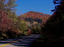
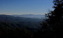
The Chilhowee section of the parkway, which has been open since 1966, has 8 overlooks on its south side, looking into the Smokies, and 4 overlooks on its north side, looking into the Tennessee Valley. An observation tower has been placed atop Look Rock, allowing for a 360-degree view of the Western Smokies and Blount County. A half-mile trail connects the tower to a parking area along the parkway.

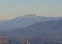
Clingmans Dome
Clingmans Dome is a mountain in the Great Smoky Mountains of Tennessee and North Carolina, in the southeastern United States. At an elevation of , it is the highest mountain in the Smokies, the highest point in the state of Tennessee, and the highest point along the Appalachian Trail...
and Thunderhead Mountain
Thunderhead Mountain
Thunderhead Mountain is a mountain in the west-central part of the Great Smoky Mountains, located in the Southeastern United States. Rising along the border between Tennessee and North Carolina, the mountain dominates the Western Smokies. The Appalachian Trail crosses its summit, making it a...
are visible to the south, and Mount Le Conte
Mount Le Conte
Mount Le Conte is a mountain in Sevier County, Tennessee located within the Great Smoky Mountains National Park. At it is the third highest peak in the national park, behind Clingmans Dome and Mount Guyot...
is visible to the southeast. On a clear day, the high peaks of the Eastern Smokies— Mount Guyot
Mount Guyot (Great Smoky Mountains)
Mount Guyot is a mountain in the eastern Great Smoky Mountains, located inthe southeastern United States. At above sea level, Guyot is the fourth-highestsummit in the eastern U.S., and the second-highest in the Great Smoky Mountains National Park...
, Mount Chapman
Mount Chapman
Mount Chapman is a mountain in the Great Smoky Mountains, located in the Southeastern United States. It has an elevation of 6,417 feet above sea level. While the mountain is located deep within the Great Smokies, the Appalachian Trail crosses its eastern slope, coming to within of the summit...
, and Old Black
Old Black (Great Smoky Mountains)
Old Black is a mountain in the Great Smoky Mountains, located in the Southeastern United States. While often overshadowed by Mount Guyot, its higher neighbor to the south, Old Black is the 4th-highest mountain in...
— are visible toward the east. The Rich Mountain/Cades Cove Mountain massif
Massif
In geology, a massif is a section of a planet's crust that is demarcated by faults or flexures. In the movement of the crust, a massif tends to retain its internal structure while being displaced as a whole...
dominates the view immediately to the south and southeast. Gregory Bald
Gregory Bald
Gregory Bald is a mountain on the western fringe of the Great Smoky Mountains. It has an elevation of 4,949 feet above sea level. The mountain's majestic summit makes it a popular hiking destination....
rises like a giant dome to the southwest. To the west, the Yellow Creek section of the Unicoi Mountains
Unicoi Range
The Unicoi Mountains are a mountain range rising along the border between Tennessee and North Carolina in the southeastern United States. They are part of the Blue Ridge Mountain Province of the Southern Appalachian Mountains. The Unicois are located immediately south of the Great Smoky Mountains...
is visible, along with a dramatic view of Chilhowee's crest.
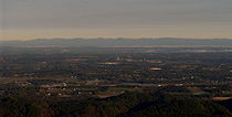
Looking north from Look Rock, most of Blount County and parts of Loudon County and Monroe County are visible. McGhee-Tyson Airport presents as a long greenish strip to the north, and the lights of South Knoxville begin to appear around sunset. The Cumberland Plateau
Cumberland Plateau
The Cumberland Plateau is the southern part of the Appalachian Plateau. It includes much of eastern Kentucky and western West Virginia, part of Tennessee, and a small portion of northern Alabama and northwest Georgia . The terms "Allegheny Plateau" and the "Cumberland Plateau" both refer to the...
dominates much of the northern horizon.
Foothills Parkway crosses Green Mountain in diagonal fashion, traversing the southwest and northeastern flanks of the mountain. From the southwest section, Mount Cammerer
Mount Cammerer
Mount Cammerer is a mountain on the northeastern fringe of the Great Smoky Mountains, in the Southeastern United States. The mountain is situated on the state line between Cocke County, Tennessee and Haywood County, North Carolina...
and the Eastern Smokies dominate the view. From the northeast section, English Mountain presents as a large ridge to the northwest, and Hall Top rises in peak-like fashion to the east. The lights of Newport are visible early in the morning and later in the evening.