
Unicoi Range
Encyclopedia
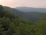
The Unicoi Mountains are a mountain range rising along the border between Tennessee
and North Carolina
in the southeastern United States. They are part of the Blue Ridge Mountain Province
of the Southern Appalachian Mountains
. The Unicois are located immediately south of the Great Smoky Mountains
and immediately west of the Cheoah Mountains. Most of the range is protected as a national forest
, namely the Cherokee National Forest
on the Tennessee side and the Nantahala National Forest
on the North Carolina side— although some parts have been designated as wilderness areas and are thus more strictly regulated.
The Unicoi Mountains remain one of the most primitive, undeveloped areas in the eastern United States. Human habitation in the range's river valleys and deep hollows was never more than sparse, and while logging occurred, logging operations in the Unicoi area were not as extensive as in other forested areas in the region. The Joyce Kilmer Memorial Forest, located in the northeastern Unicois, is home to one of the last remaining old growth cove
hardwood forests in the eastern United States. Grassy balds and heath balds
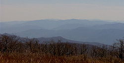
are not an uncommon occurrence atop summits in the Unicoi Mountains, the highest of which rise to elevations of over 5,000 feet. The Cherohala Skyway
— a national scenic byway completed in 1996— traverses the crest of the Unicoi Mountains connecting Tellico Plains, Tennessee
with Robbinsville, North Carolina
.
The name "Unicoi" comes from the Cherokee
word unega, which means "white." It refers to the low-lying clouds and fog that often drape the Southern Appalachian mountains in the early morning or on humid or moist days. The name "Unaka"— which historically refers to the mountains along the Tennessee-North Carolina border— has the same root as "Unicoi."
 The Unicoi Mountains stretch for roughly 37 miles (59.5 km) between the Little Tennessee River
in the north and the Hiwassee River
to the south, and for approximately 60 miles (96.6 km) from its foothills along the Tennessee River
at the range's western extreme to the Cheoah River
at its eastern extreme. The range covers just over 1000 square miles (2,590 km²).
The sources of several rivers and major streams are located high in the Unicoi Mountains. The Tellico River
rises on the slopes of McDaniel Bald in the southeastern corner of the Unicois and flows northwestward across the entire range before emptying into the Little Tennessee River
near Vonore, Tennessee
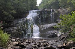
. Another tributary of the Little Tennessee, Citico Creek, is formed by the convergence of two streams which rise in a densely-forested area of the northwestern Unicois known as Jeffrey Hell. The Bald River rises on the slopes of Beaverdam Bald in the southern Unicois and winds its way northward through a scenic gorge before plunging over an oft-photographed 90 feet (27.4 m) waterfall en route to its mouth along the Tellico River. Santeetlah Creek rises on the western slope of Huckleberry Knob and flows down around the base of the mountain en route to the Santeetlah Lake impoundment of the Cheoah River to the east. Its tributary, Little Santeetlah Creek, drains the Joyce Kilmer Memorial Forest.
, a cross-country hiking trail that traverses the Southern Appalachian Mountains, passes over several summits in the Unicois.
 The Unicoi Mountains consist chiefly of Precambrian
metasedimentary rocks of a type known as the Ocoee Supergroup, formed over a billion years ago from ancient ocean deposits. Quaternary Period
rocks are sometimes found in alluvial areas along streambeds. The Unicoi Mountains were formed roughly 250 million years ago during the Alleghenian orogeny, when a continental collision thrust the rocks upward.
The Unicoi Mountains are coated by a primarily second-growth mixed hardwood and pine forest. Cove hardwood forests are typically found at the lower elevations along rivers and streams, and chiefly consist of yellow poplar, white oak, red oak, hemlock, and multiple other species. A mixed hardwood-pine forest covers the mountain slopes, and chiefly consists of white oak, red oak, hickory, table mountain pine
, pitch pine
, and shortleaf pine
.
While the vast majority of trees in the Unicoi Mountains are second-growth, the range is home to one of the few remaining stands of old growth forest in the eastern United States. The Joyce Kilmer Memorial Forest along Little Santeetlah Creek is home to a substantial stand of virgin cove hardwood forest, and contains some of the oldest and tallest trees in the Unicoi Range. The largest trees in Joyce Kilmer are over 150 feet (45.7 m) tall and have circumferences of just over 20 feet (6.1 m). The oldest trees in the forest are over 400 years old. Other stands of old growth forest include a 187 acre (0.75676282 km²) patch around Falls Branch Falls and a remote section of the Citico Creek Wilderness near Glenn Gap.
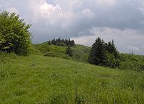
The understories of the mountain slopes and ridgecrests are often covered by dense thickets of rhododendron
and mountain laurel. These thickets are often called "hells" due to their general impassability. The most outstanding example of rhododendron-laurel thicket is Jeffrey Hell, located in the Citico Creek Wilderness. Grassy balds—a type of highland meadow consisting of fields of thick grass and sparse tree coverage—are not uncommon in the higher elevations. The summit of the highest mountain in the range—Huckleberry Knob—is a grassy bald. Other grassy balds include Oak Knob (a subpeak of Huckleberry), Hooper Bald, and Bob Bald (a subpeak of Stratton).
used a footpath in the southern Unicoi Mountains to travel from one side of the southern Appalachian range to the other. Known as the Wachesa Trail (after a later Cherokee who lived at its eastern terminus), the path stretched from modern Murphy, North Carolina
to a halfway point near Beaverdam Creek and descended through Unicoi Gap to Coker Creek. Present-day Joe Brown Highway roughly follows the ancient trail.
By the time Euro-American explorers arrived in the region in the late 17th century and early 18th century, the Cherokee had established numerous villages in the outlying areas of the Unicoi Mountains. The Middle towns— located in the Robbinsville vicinity— included Tassetchee, Elijay, and Nequassee
. The Overhill towns
included Tallassee
, Chilhowee
, Citico
, and numerous other villages in the Little Tennessee Valley at the range's northern extremes, Great Tellico
along the Tellico River in modern Tellico Plains, and Great Hiwassee
along the Hiwassee River at the western base of Starr Mountain. Excavations conducted at Citico (at the mouth of Citico Creek) revealed that it is a multiphase site, with periods of occupation stretching back thousands of years.
 16th-century Spanish explorers were the first Europeans to see the Unicoi Mountains. In 1540, the Hernando de Soto
expedition passed just west of the mountains en route from the Chiaha
villages in East Tennessee to the Coosa chiefdom
in northern Georgia. In 1567, the Juan Pardo
expedition visited the villages of "Chalahume" and "Satapo" (later Chilhowee and Citico) in the Little Tennessee Valley while attempting to find a route between Spanish settlements on the Atlantic coasts and Spanish settlements in Mexico.
While English explorers and traders were probably using the Wachesa Trail as early as the 1690s, the first documented crossing was that of Colonel George Chicken in 1725. Chicken, a South Carolina emissary travelling to the Overhill towns in hopes of obtaining their support in the colony's ongoing struggles with the Creek tribe, left Little Tellico in the Middle towns at 10am on July 24, 1725 and proceeded approximately 25 miles (40.2 km) across the southern Unicois to a campsite "about five Miles Short of a place called the Beaver Dam." Chicken's party departed at 5am the following morning and arrived at the village of Great Tellico at 3pm, having travelled another 25 miles (40.2 km).
In 1730, Sir Alexander Cuming, a flamboyant English emissary, travelled from Charleston, South Carolina
to the Overhill town of Tanasi
in the lower Little Tennessee Valley in hopes of gaining the allegiance of the Cherokee for England (although Cuming's trip was part of an attempt to scam the people of Charleston). Cuming followed the same trail Chicken had taken five years earlier, departing from Tassetchee in the Middle towns and proceeding to a campsite "3 miles from Beaver Dam Creek." The following day, Cuming's party passed over "Ooneekawy Mountain" and proceeded another 12 miles (19.3 km) to Great Tellico.
 Although the Unicoi Turnpike— which closely followed the old Wachesa Trail— was completed in 1816, the Unicoi Mountains remained largely devoid of all but a few mountain families. The family of John Stratton (1799–1862) settled in the area now known as Stratton Meadows (atop the main crest near where Cherohala Skyway crosses the state line) in the 1830s. John's father, Absolum, died while visiting his son in 1852 and is thus buried at Stratton Meadows. John's son, Robert "Bob" Stratton (1825–1864) eventually moved a few miles north of Stratton Meadows to the mountain that now bears his name, Stratton Bald. Stratton lived just west of the mountain's summit in a meadow now known as "Bob Bald" until 1864, when he was ambushed and killed by bushwhackers at the height of the U.S. Civil War.
Sometime after the Civil War, the family of John and Albertine Denton moved to Little Santeetlah Creek, where they built a log cabin. According to family lore, the Dentons lived in a hewed-out giant chestnut tree
log while they were building their cabin. The log had a diameter of over 6 feet (1.8 m) and housed the entire family of seven in two rooms. The Denton family remained in the area until around 1900. The cabin was dismantled by the Civilian Conservation Corps
in the 1930s, and today only a chimney fall remains.
 Around 1911, George Gordon Moore— an official for the Whiting Manufacturing Company— attempted to establish a boar
hunting reserve atop Hooper Bald in the southeastern Unicois. The reserve consisted of a 500 acres (2 km²) enclosed lot stocked with Russian blue boars imported from Europe. Most of the boars were able to escape from the lot, however, and fled to the remote slopes and stream bottoms. The introduced boars continue to thrive in the Appalachian environment to this day. The boars are considered a nuisance by forest officials due to the erosion damage they cause to the local watersheds.
In 1915, the Babcock Lumber Company began a massive logging operation in the northern Unicoi Mountains. The company logged nearly two-thirds of the Slickrock Creek watershed until 1922, when the construction of Calderwood Dam
along the Little Tennessee River threatened to flood the railroad tracks leading into the area and forcing an end to the company's logging operations in what is now the Joyce-Kilmer Slickrock Wilderness. That same year, however, Babcock began logging the Citico Creek watershed on the Tennessee side of the mountains. This operation continued until 1925, when a massive forest fire destroyed the company's logging tramways and wiped out nearly half the forest. The company continued low-scale logging in the Doublecamp area until 1929. The logging practices of Babcock and other logging companies proved extremely detrimental to the forest environment of the Unicoi Mountains, and the U.S. Forest Service began buying up the land in the 1930s. The forest service's policy of letting natural processes heal the forest has allowed the forest to recover to a great extent.
In 1958, Sam Williams— a resident of Tellico Plains— led a well-publicized covered wagon train across the Unicoi Mountains to Murphy, North Carolina, which became an annual event to promote the construction of a highway linking the Tennessee and North Carolina side of the Unicois. The original path of the highway would follow the ancient path of the Wachesa Trail and Unicoi Turnpike, although organizers chose a more feasible route over the Unicoi crest to Robbinsville. The highway— named "Cherohala Skyway" (a fusion of "Cherokee" and "Nantahala")— was completed in 1996.
 Along with the Cherokee National Forest and the Nantahala National Forest, several designated areas protect various parts of the Unicoi Mountains.
Tennessee
Tennessee is a U.S. state located in the Southeastern United States. It has a population of 6,346,105, making it the nation's 17th-largest state by population, and covers , making it the 36th-largest by total land area...
and North Carolina
North Carolina
North Carolina is a state located in the southeastern United States. The state borders South Carolina and Georgia to the south, Tennessee to the west and Virginia to the north. North Carolina contains 100 counties. Its capital is Raleigh, and its largest city is Charlotte...
in the southeastern United States. They are part of the Blue Ridge Mountain Province
Blue Ridge Mountains
The Blue Ridge Mountains are a physiographic province of the larger Appalachian Mountains range. This province consists of northern and southern physiographic regions, which divide near the Roanoke River gap. The mountain range is located in the eastern United States, starting at its southern-most...
of the Southern Appalachian Mountains
Appalachian Mountains
The Appalachian Mountains #Whether the stressed vowel is or ,#Whether the "ch" is pronounced as a fricative or an affricate , and#Whether the final vowel is the monophthong or the diphthong .), often called the Appalachians, are a system of mountains in eastern North America. The Appalachians...
. The Unicois are located immediately south of the Great Smoky Mountains
Great Smoky Mountains
The Great Smoky Mountains are a mountain range rising along the Tennessee–North Carolina border in the southeastern United States. They are a subrange of the Appalachian Mountains, and form part of the Blue Ridge Physiographic Province. The range is sometimes called the Smoky Mountains or the...
and immediately west of the Cheoah Mountains. Most of the range is protected as a national forest
United States National Forest
National Forest is a classification of federal lands in the United States.National Forests are largely forest and woodland areas owned by the federal government and managed by the United States Forest Service, part of the United States Department of Agriculture. Land management of these areas...
, namely the Cherokee National Forest
Cherokee National Forest
The Cherokee National Forest is a large National Forest created on July 19, 1936, by U.S. President Franklin Roosevelt, operated by the U.S. Forest Service and encompassing some 640,000 acres .-Location:...
on the Tennessee side and the Nantahala National Forest
Nantahala National Forest
The Nantahala National Forest, established in 1920, is a national forest located in the American state of North Carolina. The word "Nantahala" is a Cherokee word meaning "Land of the Noonday Sun." The name is appropriate as, in some spots, the sun only reaches the floors of the deep gorges of the...
on the North Carolina side— although some parts have been designated as wilderness areas and are thus more strictly regulated.
The Unicoi Mountains remain one of the most primitive, undeveloped areas in the eastern United States. Human habitation in the range's river valleys and deep hollows was never more than sparse, and while logging occurred, logging operations in the Unicoi area were not as extensive as in other forested areas in the region. The Joyce Kilmer Memorial Forest, located in the northeastern Unicois, is home to one of the last remaining old growth cove
Cove (Appalachian Mountains)
In the central and southern Appalachian Mountains of Eastern North America, a cove is a small valley between two ridge lines that is closed at one or both ends....
hardwood forests in the eastern United States. Grassy balds and heath balds
Appalachian balds
In the Appalachian Mountains of the eastern United States, balds are mountain summits or crests covered primarily by thick vegetation of native grasses or shrubs occurring in areas where heavy forest growth would be expected....
are not an uncommon occurrence atop summits in the Unicoi Mountains, the highest of which rise to elevations of over 5,000 feet. The Cherohala Skyway
Cherohala Skyway
The Cherohala Skyway is a National Scenic Byway that connects Tellico Plains, Tennessee, to Robbinsville, North Carolina in the southeastern United States. Its name is a portmanteau of Cherokee and Nantahala, the two national forests through which it passes...
— a national scenic byway completed in 1996— traverses the crest of the Unicoi Mountains connecting Tellico Plains, Tennessee
Tellico Plains, Tennessee
Tellico Plains is a town in Monroe County, Tennessee, United States. The population was 859 at the 2000 census.-Geography:Tellico Plains is located at ....
with Robbinsville, North Carolina
Robbinsville, North Carolina
Robbinsville is a town in Graham County, North Carolina, United States. The population was 747 at the 2000 census. It is the county seat of Graham County. Robbinsville High School is the only high school in Graham County...
.
The name "Unicoi" comes from the Cherokee
Cherokee
The Cherokee are a Native American people historically settled in the Southeastern United States . Linguistically, they are part of the Iroquoian language family...
word unega, which means "white." It refers to the low-lying clouds and fog that often drape the Southern Appalachian mountains in the early morning or on humid or moist days. The name "Unaka"— which historically refers to the mountains along the Tennessee-North Carolina border— has the same root as "Unicoi."
Geography
Little Tennessee River
The Little Tennessee River is a tributary of the Tennessee River, approximately 135 miles long, in the Appalachian Mountains in the southeastern United States.-Geography:...
in the north and the Hiwassee River
Hiwassee River
The Hiwassee River has its headwaters on the north slope of Rocky Mountain in Towns County in northern Georgia and flows northward into North Carolina before turning westward into Tennessee, flowing into the Tennessee River a few miles west of State Route 58 in Meigs County, Tennessee...
to the south, and for approximately 60 miles (96.6 km) from its foothills along the Tennessee River
Tennessee River
The Tennessee River is the largest tributary of the Ohio River. It is approximately 652 miles long and is located in the southeastern United States in the Tennessee Valley. The river was once popularly known as the Cherokee River, among other names...
at the range's western extreme to the Cheoah River
Cheoah River
The Cheoah River is a tributary of the Little Tennessee River in North Carolina in the United States.It is located in Graham County in far western North Carolina, near Robbinsville, and is approximately 20 miles in length...
at its eastern extreme. The range covers just over 1000 square miles (2,590 km²).
The sources of several rivers and major streams are located high in the Unicoi Mountains. The Tellico River
Tellico River
The Tellico River rises in the westernmost mountains of North Carolina, but it flows mainly through Monroe County, Tennessee. It is a major tributary of the Little Tennessee River and the namesake of Tellico Reservoir, a reservoir created by Tellico Dam, which impounds the lower reaches of the...
rises on the slopes of McDaniel Bald in the southeastern corner of the Unicois and flows northwestward across the entire range before emptying into the Little Tennessee River
Little Tennessee River
The Little Tennessee River is a tributary of the Tennessee River, approximately 135 miles long, in the Appalachian Mountains in the southeastern United States.-Geography:...
near Vonore, Tennessee
Vonore, Tennessee
Vonore is a town in Blount and Monroe counties in the U.S. state of Tennessee. The population was 1,162 as of the 2000 census.-Geography:Vonore is located at ....
. Another tributary of the Little Tennessee, Citico Creek, is formed by the convergence of two streams which rise in a densely-forested area of the northwestern Unicois known as Jeffrey Hell. The Bald River rises on the slopes of Beaverdam Bald in the southern Unicois and winds its way northward through a scenic gorge before plunging over an oft-photographed 90 feet (27.4 m) waterfall en route to its mouth along the Tellico River. Santeetlah Creek rises on the western slope of Huckleberry Knob and flows down around the base of the mountain en route to the Santeetlah Lake impoundment of the Cheoah River to the east. Its tributary, Little Santeetlah Creek, drains the Joyce Kilmer Memorial Forest.
Major peaks
The highest summits in the Unicoi Range rise above 5,000 feet (1,500 meters), although most fall between 4,000 and 5,000 feet along the two crests and between 3,000 and 4,000 feet beyond the crest to the east and west. Huckleberry Knob— the highest mountain in the Unicoi Range at 5560 feet (1,694.7 m)— has 3400 feet (1,036.3 m) of topographical prominence. Other summits with 1,000+ feet of prominence include Stratton Bald along the southern boundary of the Joyce Kilmer-Slickrock Wilderness and Beaverdam Bald in the southern part of the range. The Benton MacKaye TrailBenton MacKaye Trail
The Benton MacKaye Trail or BMT is a footpath nearly in length in the Appalachian Mountains in the southeastern United States and is blazed by a white diamond, 5" across by 7" tall...
, a cross-country hiking trail that traverses the Southern Appalachian Mountains, passes over several summits in the Unicois.
| Mountain | Elevation | General area | Coordinates | Access |
|---|---|---|---|---|
| Huckleberry Knob | 5,560 ft/1,695 m | Central Unicois | 35.3221, -83.9939 | Huckleberry Trail |
| Big Junction | 5480 ft/1670 m | Central Unicois | 35.30526, -84.013994 | Cherohala Skyway |
| Haw Knob | 5,472 ft/1,668 m | Central Unicois | 35.309621, -84.026652 | Benton MacKaye Trail |
| Hooper Bald | 5,429 ft/1,655 m | Central Unicois | 35.305365, -83.994513 | Hooper Bald Trail |
| Stratton Bald | 5,360 ft/1,634 m | Joyce Kilmer-Slickrock Wilderness | 35.373403, -83.992979 | Stratton Bald Trail (#54) |
| Bob Bald | 5,282 ft/1,610 m | Joyce Kilmer-Slickrock Wilderness | 35.37093, -84.00069 | Stratton Bald Trail (#54) |
| Haoe | 5,249 ft/1,600 m | Joyce Kilmer-Slickrock Wilderness | 35.385954, -83.969372 | Trail #53 |
| Johns Knob | 4,908 ft/1,496 m | Central Unicois | 35.330974, -84.030215 | Benton MacKaye Trail |
| McDaniel Bald | 4,640 ft/1,414 m | Southeastern Unicois | 35.3144444, -83.9927778 | |
| Rockstack | 4,420 ft/1,347 m | CCW/JKSW boundary | 35.397674, -84.013865 | Benton MacKaye Trail |
| Big Fodderstack | 4,346 ft/1325 m | CCW/JKSW boundary | 35.412352, -84.027499 | Benton MacKaye Trail |
| Beaverdam Bald | 4,259 ft/1,298 m | Southern Unicois | 35.249941, -84.125076 | Benton MacKaye Trail |
| Hemlock Knob | 4,019 ft/1,225 m | Citico Creek Wilderness | 35.359615, -84.103051 | Cherohala Skyway |
| Cedar Top | 4,008 ft/1,222 m | Eastern Unicois | 35.32586, -83.92692 | |
| Ikes Peak | 3,820 ft/1,164 m | Citico Creek Wilderness | 35.38496, -84.05371 | |
| Salt Spring Mountain | 3,155 ft/962 m | Citico Creek Wilderness | 35.46476, -84.05253 | |
| Starr Mountain | 2,340 ft/713 m | Etowah, Tennessee Etowah, Tennessee Etowah is a city in McMinn County, Tennessee, United States. The population was 3,663 at the 2000 census.-History:Etowah was founded in 1906, primarily as a location for a depot on the Louisville & Nashville Railroad line as part of a more direct route between Atlanta, Georgia and Cincinnati, Ohio... |
35.273962, -84.508912 |
Natural information
Precambrian
The Precambrian is the name which describes the large span of time in Earth's history before the current Phanerozoic Eon, and is a Supereon divided into several eons of the geologic time scale...
metasedimentary rocks of a type known as the Ocoee Supergroup, formed over a billion years ago from ancient ocean deposits. Quaternary Period
Quaternary
The Quaternary Period is the most recent of the three periods of the Cenozoic Era in the geologic time scale of the ICS. It follows the Neogene Period, spanning 2.588 ± 0.005 million years ago to the present...
rocks are sometimes found in alluvial areas along streambeds. The Unicoi Mountains were formed roughly 250 million years ago during the Alleghenian orogeny, when a continental collision thrust the rocks upward.
The Unicoi Mountains are coated by a primarily second-growth mixed hardwood and pine forest. Cove hardwood forests are typically found at the lower elevations along rivers and streams, and chiefly consist of yellow poplar, white oak, red oak, hemlock, and multiple other species. A mixed hardwood-pine forest covers the mountain slopes, and chiefly consists of white oak, red oak, hickory, table mountain pine
Table Mountain Pine
Pinus pungens, the Table Mountain Pine, is a small pine native to the Appalachian Mountains in the United States. Table Mountain Pine, Pinus pungens, is also called Hickory Pine or Mountain Pine, though the latter name usually refers to the European species Mountain Pine - Pinus...
, pitch pine
Pitch Pine
The Pitch Pine, Pinus rigida, is a small-to-medium sized pine, native to eastern North America. This species occasionally hybridizes with other pine species such as Loblolly Pine , Shortleaf Pine , and Pond Pine The Pitch Pine, Pinus rigida, is a small-to-medium sized (6-30 meters or 20-100 feet)...
, and shortleaf pine
Shortleaf Pine
Pinus echinata is a species of pine native to the eastern United States from southern New York south to northern Florida, west to the extreme southeast of Kansas, and southwest to eastern Texas. The tree is variable in form, sometimes straight, sometimes crooked, with an irregular crown...
.
While the vast majority of trees in the Unicoi Mountains are second-growth, the range is home to one of the few remaining stands of old growth forest in the eastern United States. The Joyce Kilmer Memorial Forest along Little Santeetlah Creek is home to a substantial stand of virgin cove hardwood forest, and contains some of the oldest and tallest trees in the Unicoi Range. The largest trees in Joyce Kilmer are over 150 feet (45.7 m) tall and have circumferences of just over 20 feet (6.1 m). The oldest trees in the forest are over 400 years old. Other stands of old growth forest include a 187 acre (0.75676282 km²) patch around Falls Branch Falls and a remote section of the Citico Creek Wilderness near Glenn Gap.
The understories of the mountain slopes and ridgecrests are often covered by dense thickets of rhododendron
Rhododendron
Rhododendron is a genus of over 1 000 species of woody plants in the heath family, most with showy flowers...
and mountain laurel. These thickets are often called "hells" due to their general impassability. The most outstanding example of rhododendron-laurel thicket is Jeffrey Hell, located in the Citico Creek Wilderness. Grassy balds—a type of highland meadow consisting of fields of thick grass and sparse tree coverage—are not uncommon in the higher elevations. The summit of the highest mountain in the range—Huckleberry Knob—is a grassy bald. Other grassy balds include Oak Knob (a subpeak of Huckleberry), Hooper Bald, and Bob Bald (a subpeak of Stratton).
History
For centuries, Native AmericansNative Americans in the United States
Native Americans in the United States are the indigenous peoples in North America within the boundaries of the present-day continental United States, parts of Alaska, and the island state of Hawaii. They are composed of numerous, distinct tribes, states, and ethnic groups, many of which survive as...
used a footpath in the southern Unicoi Mountains to travel from one side of the southern Appalachian range to the other. Known as the Wachesa Trail (after a later Cherokee who lived at its eastern terminus), the path stretched from modern Murphy, North Carolina
Murphy, North Carolina
-Household Income:The median income for a household in the town was $24,952, and the median income for a family was $35,234. Males had a median income of $30,395 versus $16,908 for females. The per capita income for the town was $16,926...
to a halfway point near Beaverdam Creek and descended through Unicoi Gap to Coker Creek. Present-day Joe Brown Highway roughly follows the ancient trail.
By the time Euro-American explorers arrived in the region in the late 17th century and early 18th century, the Cherokee had established numerous villages in the outlying areas of the Unicoi Mountains. The Middle towns— located in the Robbinsville vicinity— included Tassetchee, Elijay, and Nequassee
Nikwasi
Nikwasi was an important Cherokee town located on the Little Tennessee River at the site of present-day Franklin, North Carolina....
. The Overhill towns
Overhill Cherokee
The term Overhill Cherokee refers to the former Cherokee settlements located in what is now Tennessee in the southeastern United States. The name was given by 18th century European traders and explorers who had to cross the Appalachian Mountains to reach these settlements when traveling from...
included Tallassee
Tallassee (Cherokee town)
Tallassee is a prehistoric and historic Native American site in Blount County and Monroe County, Tennessee, in the southeastern United States. Tallassee was the southernmost of a string of Overhill Cherokee villages that spanned the lower Little Tennessee River in the 18th century...
, Chilhowee
Chilhowee (Cherokee town)
Chilhowee was a prehistoric and historic Native American site in Blount County and Monroe County, Tennessee, in the southeastern United States...
, Citico
Citico (Tellico archaeological site)
Citico is a prehistoric and historic Native American site in Monroe County, Tennessee, in the southeastern United States. The site's namesake Cherokee village was the largest of the Overhill towns, housing an estimated population of 1,000 by the mid-18th century...
, and numerous other villages in the Little Tennessee Valley at the range's northern extremes, Great Tellico
Great Tellico
Great Tellico was a Cherokee town at the site of present-day Tellico Plains, Tennessee, where the Tellico River emerges from the Appalachian Mountains. Great Tellico was one of the largest Cherokee towns in the region, and had a sister town nearby named Chatuga. Its name in Cherokee is more...
along the Tellico River in modern Tellico Plains, and Great Hiwassee
Great Hiwassee
Great Hiwassee was an important Overhill Cherokee town from the late 17th through the early 19th centuries. It was located on the Hiwassee River in present-day Polk County, Tennessee, on the north bank of the river where modern U.S. Route 411 crosses the river...
along the Hiwassee River at the western base of Starr Mountain. Excavations conducted at Citico (at the mouth of Citico Creek) revealed that it is a multiphase site, with periods of occupation stretching back thousands of years.
Early Euro-American history
Hernando de Soto (explorer)
Hernando de Soto was a Spanish explorer and conquistador who, while leading the first European expedition deep into the territory of the modern-day United States, was the first European documented to have crossed the Mississippi River....
expedition passed just west of the mountains en route from the Chiaha
Chiaha
Chiaha was a horticultural Native American chiefdom located in the lower French Broad River valley in modern East Tennessee, in the southeastern United States. They lived in raised structures within boundaries of several stable villages. These overlooked the fields of maize, beans, squash, and...
villages in East Tennessee to the Coosa chiefdom
Coosa chiefdom
The Coosa chiefdom was a powerful Native American paramount chiefdom near what are now Gordon and Murray counties in Georgia, in the United States. It was inhabited from about 1400 until about 1600, and dominated several smaller chiefdoms...
in northern Georgia. In 1567, the Juan Pardo
Juan Pardo (explorer)
Juan Pardo was a Spanish explorer and conquistador who was active in the later half of the sixteenth century. He led a Spanish expedition through what is now North and South Carolina and into eastern Tennessee. He established Fort San Felipe, South Carolina , and the village of Santa Elena on...
expedition visited the villages of "Chalahume" and "Satapo" (later Chilhowee and Citico) in the Little Tennessee Valley while attempting to find a route between Spanish settlements on the Atlantic coasts and Spanish settlements in Mexico.
While English explorers and traders were probably using the Wachesa Trail as early as the 1690s, the first documented crossing was that of Colonel George Chicken in 1725. Chicken, a South Carolina emissary travelling to the Overhill towns in hopes of obtaining their support in the colony's ongoing struggles with the Creek tribe, left Little Tellico in the Middle towns at 10am on July 24, 1725 and proceeded approximately 25 miles (40.2 km) across the southern Unicois to a campsite "about five Miles Short of a place called the Beaver Dam." Chicken's party departed at 5am the following morning and arrived at the village of Great Tellico at 3pm, having travelled another 25 miles (40.2 km).
In 1730, Sir Alexander Cuming, a flamboyant English emissary, travelled from Charleston, South Carolina
Charleston, South Carolina
Charleston is the second largest city in the U.S. state of South Carolina. It was made the county seat of Charleston County in 1901 when Charleston County was founded. The city's original name was Charles Towne in 1670, and it moved to its present location from a location on the west bank of the...
to the Overhill town of Tanasi
Tanasi
Tanasi is a historic Overhill Cherokee village site in Monroe County, Tennessee, in the southeastern United States. The village is best known as the namesake for the state of Tennessee...
in the lower Little Tennessee Valley in hopes of gaining the allegiance of the Cherokee for England (although Cuming's trip was part of an attempt to scam the people of Charleston). Cuming followed the same trail Chicken had taken five years earlier, departing from Tassetchee in the Middle towns and proceeding to a campsite "3 miles from Beaver Dam Creek." The following day, Cuming's party passed over "Ooneekawy Mountain" and proceeded another 12 miles (19.3 km) to Great Tellico.
The 19th century
Sometime after the Civil War, the family of John and Albertine Denton moved to Little Santeetlah Creek, where they built a log cabin. According to family lore, the Dentons lived in a hewed-out giant chestnut tree
American Chestnut
The American Chestnut is a large, deciduous tree of the beech family native to eastern North America. Before the species was devastated by the chestnut blight, a fungal disease, it was one of the most important forest trees throughout its range...
log while they were building their cabin. The log had a diameter of over 6 feet (1.8 m) and housed the entire family of seven in two rooms. The Denton family remained in the area until around 1900. The cabin was dismantled by the Civilian Conservation Corps
Civilian Conservation Corps
The Civilian Conservation Corps was a public work relief program that operated from 1933 to 1942 in the United States for unemployed, unmarried men from relief families, ages 18–25. A part of the New Deal of President Franklin D...
in the 1930s, and today only a chimney fall remains.
The early 20th century
Boar
Wild boar, also wild pig, is a species of the pig genus Sus, part of the biological family Suidae. The species includes many subspecies. It is the wild ancestor of the domestic pig, an animal with which it freely hybridises...
hunting reserve atop Hooper Bald in the southeastern Unicois. The reserve consisted of a 500 acres (2 km²) enclosed lot stocked with Russian blue boars imported from Europe. Most of the boars were able to escape from the lot, however, and fled to the remote slopes and stream bottoms. The introduced boars continue to thrive in the Appalachian environment to this day. The boars are considered a nuisance by forest officials due to the erosion damage they cause to the local watersheds.
In 1915, the Babcock Lumber Company began a massive logging operation in the northern Unicoi Mountains. The company logged nearly two-thirds of the Slickrock Creek watershed until 1922, when the construction of Calderwood Dam
Calderwood Dam
Calderwood Dam is a hydroelectric dam located along the Little Tennessee River in Blount and Monroe counties, Tennessee. Completed in 1930, the dam is owned and maintained by Tapoco, a subsidiary of the Aluminum Company of America , although the Tennessee Valley Authority controls the dam's...
along the Little Tennessee River threatened to flood the railroad tracks leading into the area and forcing an end to the company's logging operations in what is now the Joyce-Kilmer Slickrock Wilderness. That same year, however, Babcock began logging the Citico Creek watershed on the Tennessee side of the mountains. This operation continued until 1925, when a massive forest fire destroyed the company's logging tramways and wiped out nearly half the forest. The company continued low-scale logging in the Doublecamp area until 1929. The logging practices of Babcock and other logging companies proved extremely detrimental to the forest environment of the Unicoi Mountains, and the U.S. Forest Service began buying up the land in the 1930s. The forest service's policy of letting natural processes heal the forest has allowed the forest to recover to a great extent.
In 1958, Sam Williams— a resident of Tellico Plains— led a well-publicized covered wagon train across the Unicoi Mountains to Murphy, North Carolina, which became an annual event to promote the construction of a highway linking the Tennessee and North Carolina side of the Unicois. The original path of the highway would follow the ancient path of the Wachesa Trail and Unicoi Turnpike, although organizers chose a more feasible route over the Unicoi crest to Robbinsville. The highway— named "Cherohala Skyway" (a fusion of "Cherokee" and "Nantahala")— was completed in 1996.
Protected areas within the Unicoi Mountains
- The Joyce Kilmer-Slickrock WildernessJoyce Kilmer-Slickrock WildernessJoyce Kilmer-Slickrock Wilderness, created in 1975, covers in the Nantahala National Forest in western North Carolina and the Cherokee National Forest in eastern Tennessee, in the watersheds of the Slickrock and Little Santeetlah Creeks...
, designated as a wilderness area in 1975. It consists of 17394 acres (70.4 km²), 13,562 of which are located in North Carolina, with the rest lying just across the border in Tennessee. The Joyce Kilmer Memorial Forest consists of roughly 3800 acres (15.4 km²) of old growth hardwood forest along the Santeetlah Creek watershed. The forest's namesake, Joyce Kilmer, was a poet and journalist killed in World War IWorld War IWorld War I , which was predominantly called the World War or the Great War from its occurrence until 1939, and the First World War or World War I thereafter, was a major war centred in Europe that began on 28 July 1914 and lasted until 11 November 1918...
.
- The Citico Creek WildernessCitico Creek WildernessCitico Creek Wilderness is a wilderness area within the Cherokee National Forest in the U.S. state of Tennessee. The wilderness contains the entire upper drainage of Citico Creek, which consists of the north and south forks and at least eight tributaries...
, designated as a wilderness area in 1984, protects the upper watershed of Citico Creek and consists of 16226 acres (65.7 km²).
- The Bald River Gorge Wilderness, designated as a wilderness area in 1984, consists of 3721 acres (15.1 km²). It protects the Bald River and its immediate watershed.
- The Gee Creek Wilderness, designated as a wilderness area in 1975, consists of 2493 acres (10.1 km²). It protects the Gee Creek watershed on the eastern slopes of Starr Mountain.
- The Upper Tellico Off-Road Vehicle Area, purchased in 1980. The upper watershed of the Tellico River in the southeastern Unicois is criss-crossed by multiple old logging roads and paths popular with 4x4 enthusiasts. In 2009, the U.S. Forest Service announced a decision to permanently close the Tellico Off-Road Vehicle Area when studies showed that erosion along the trails was damaging valuable brook trout waters along the river.
Resources
- [ USGS GNIS - Unicoi Mountains]
- Duncan, Barbara R. and Riggs, Brett H. Cherokee Heritage Trails Guidebook. University of North Carolina Press: Chapel Hill (2003). ISBN 0-8078-5457-3