

Wears Valley, Tennessee
Encyclopedia
Wears Valley is an unincorporated area
in Sevier County
, Tennessee
, treated by the U.S. Census Bureau as a census county division
. As of the 2000 Census, the population of Wears Valley was 6,486.
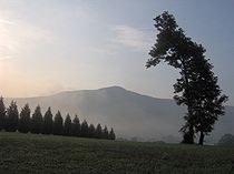
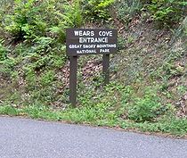
Wears Valley is situated in a valley known as Wear Cove
, which runs parallel to the Great Smoky Mountains National Park
. Like other park border communities, the history and economy of the valley are intertwined with that of the Smokies.
Both are named after Samuel Wear (1753–1817), a Revolutionary War
veteran who erected a fort near the entrance to Wear Cove in what is now Pigeon Forge.
Of the 2,585 households, 30.0% had children under the age of 18 living with them, 66.6% were married couples
living together, 7.3% had a female householder with no husband present, and 24.4% were non-families. 20.3% of all households were made up of individuals and 7.4% had someone living alone who was 65 years of age or older. The average household size was 2.51 and the average family size was 2.89.
77.8% of the population was 18 years of age or older with 12.3% being 65 years of age or older. The median age was 40.2 years. The population was 49.9% male and 50.1% female.
The median income for a household in the area was $34,479, and the median income for a family was $39,901. The per capita income
was $17,422. About 9.1% of families and 15.0% of the population were below the poverty line.
 Wears Valley is centered at 35°42′50"N 83°39′11"W (35.7139, -83.6531).http://www.topozone.com/map.asp?lat=35.71393&lon=-83.65315&size=m&u=4&datum=nad27&layer=DRG The community covers most of Wear Cove, with the national park boundary comprising the town's entire southern border and the Blount
/Sevier county line providing its western border.
U.S. Route 321
/ Tennessee Highway 73 is the community's main road, connecting Townsend
in the west with Pigeon Forge
in east, where it merges with U.S. 441. This section of 321/73 is known as "Wears Valley Road". Lyon Springs Road connects Wears Valley Road with Little River Road
inside the national park, crossing the gap between Cove Mountain and Roundtop and emerging at the Metcalf Bottoms picnic area.
When completed, a section of the Foothills Parkway
will connect Wears Valley to Walland
to the west-northwest. Most of this is finished or nearly so, but the "missing link" section northeast of Townsend must be completed with a series of bridges before this section can open. The section east of Wears Valley (at 321/73) is completely unconstructed, and will not occur in the foreseeable future.
 Wears Valley is named after Samuel Wear (1753–1817), a Revolutionary War
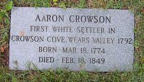
veteran who erected a fort near the entrance to the valley in what is now Pigeon Forge. The original name of the valley was "Crowson Cove," after its first settler, Aaron Crowson (1774–1849). While no one is sure why its name changed, the valley was using its current name by 1900.
Crowson arrived in Wears Valley from North Carolina in 1792 along with his friend, Peter Percefield. This was a period of elevated strife between the Cherokee
and the fast-encroaching Euro-American settlers. Wear's Fort was attacked in 1793, with Wear leading a punitive march against the Cherokee village of Tallassee
shortly thereafter. In May of 1794, Percefield was killed in a Cherokee attack. Crowson rode to Wear's Fort to get help, but the Cherokee had fled by the time he returned. Several settlers marched onward to Great Tellico
to the west, where they murdered four Cherokee while they slept. Percefield was buried on a hill in the eastern half of Wear Cove in what is now Crowson Cemetery. Later that year, Crowson received a land grant for this plot of land.
 Along with Crowson, other early settlers in Wears Valley included a Revolutionary War veteran named William Headrick (1744–1839), who arrived in 1821, and John Ogle (1788–1841), a War of 1812
veteran and son of the first settlers in Gatlinburg
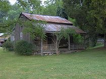
. Another War of 1812 veteran, Peter Brickey (1769–1856), arrived in 1808. Brickey operated a large farm and distillery in the valley until his death in 1856. The log house he built shortly after his arrival still stands in Smith Hollow (between Wears Valley and Townsend) and is listed on the National Register of Historic Places
.
Like many other farms in Wears Valley, the Brickey farm was ravaged by the U.S. Civil War. Isaac Trotter, who operated the iron forge at Pigeon Forge
reported a Cherokee raid in Wear Cove in 1864. Earlier in the war, a Union
army passed through the valley en route to dislodge the troops of Will Thomas
who were entrenched in Gatlinburg. William C. Pickens, a resident of Wears Valley, was one of the so-called bridge-burners
, a band of pro-Union guerillas who attempted to destroy several railroad bridges across East Tennessee in November 1861. Pickens led the failed attack on the Strawberry Plains
bridge, and was badly wounded in the attack. Pro-Union newspaper editor William "Parson" Brownlow
, wanted by Confederate authorities for complicity in the bridge burnings, hid out in Wears Valley at the home of Valentine Mattox in November 1861.
Sometime after the war, Alfred Line (1831–1897) established a farm at the base of Roundtop Mountain, near the southern half of Wear Cove. Line Spring, a clear mountain spring which flows down from the slopes of Roundtop, gave its name to a small recreational area that developed in this part of the cove. In the 1880s and 1890s, mineral-rich mountain springs were thought to have health-restoring qualities, and provided an early form of tourism for the mountain regions. In 1910, D.B. Lawson, the son of a circuit rider
who had purchased the Line farm, constructed the Line Spring Hotel. The hotel boosted the valley's economy by providing a market for local farmers.
 Around 1800, Crowson and several other settlers erected a crude log church known as the Bethlehem Church. The church was used by both Methodists and Baptists throughout the 19th century, with Baptist services being conducted by an elected pastor and Methodist services being conducted by circuit riders. On occasion, both congregations would meet in a mini-revival known as a "union meeting." In 1886, both Baptists and Methodists constructed separate structures, although union meetings were still fairly common.
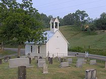
For most of the 19th century, funerals in Wears Valley were held at Headrick Cemetery, near the valley's western entrance. A large oak tree provided shelter for funeral-goers, although cold weather and rain often made apparent the need for a building in which to conduct indoor services. In 1902, according to local lore, the oak tree was destroyed by lightning, and in response, the residents erected Headrick Chapel on the cemetery's grounds. The chapel was shared by four Baptist and Methodist congregations, with funeral services having priority. The chapel's bell would ring once for every year of the deceased's life, a tradition still observed by the inhabitants of Wears Valley. In 2001, Headrick Chapel was placed on the National Register of Historic Places.
 In 1934, the Great Smoky Mountains National Park
was established. The park's border paralleled Wears Valley to the south, following the crest of Roundtop and Cove Mountain. With improvements to US-321 in the 1950s, tourist outlets began to trickle into Wears Valley. Cabin rentals and outdoor supply stores are among the more common tourism-oriented venues in the valley today.
In 2005, a group of developers led by Ron Ogle and Jerry Miller sought to build 400 houses on the slopes of Cove Mountain. This raised concern among many Wears Valley residents over the impact such development might have on Cove Mountain's scenic value. In 2007, Friends of Wears Valley— a group opposed to the development— unsuccessfully petitioned the Sevier County Regional Planning Commission to block the housing expansion on Cove Mountain. The group has posted "Save Our Mountains" signs throughout the valley, although the developers insist their plans will not harm the mountain's natural qualities.
Unincorporated area
In law, an unincorporated area is a region of land that is not a part of any municipality.To "incorporate" in this context means to form a municipal corporation, a city, town, or village with its own government. An unincorporated community is usually not subject to or taxed by a municipal government...
in Sevier County
Sevier County, Tennessee
Sevier County is a county of the state of Tennessee, United States. Its population was 71,170 at the 2000 United States Census. It is included in the Sevierville, Tennessee, Micropolitan Statistical Area, which is included in the Knoxville-Sevierville-La Follette, TN Combined Statistical Area. The...
, Tennessee
Tennessee
Tennessee is a U.S. state located in the Southeastern United States. It has a population of 6,346,105, making it the nation's 17th-largest state by population, and covers , making it the 36th-largest by total land area...
, treated by the U.S. Census Bureau as a census county division
Census County Division
A Census County Division is a subdivision of a county used by the United States Census Bureau for the purpose of presenting statistical data. A CCD is a relatively permanent statistical area delineated cooperatively by the Census Bureau and state and local government authorities...
. As of the 2000 Census, the population of Wears Valley was 6,486.
Wears Valley is situated in a valley known as Wear Cove
Wear Cove
Wear Cove is a valley in southwestern Sevier County, Tennessee. It runs parallel to the Great Smoky Mountains National Park just to its south. Like other park border regions, the history and economy of the valley are intertwined with that of the Smokies...
, which runs parallel to the Great Smoky Mountains National Park
Great Smoky Mountains National Park
Great Smoky Mountains National Park is a United States National Park and UNESCO World Heritage Site that straddles the ridgeline of the Great Smoky Mountains, part of the Blue Ridge Mountains, which are a division of the larger Appalachian Mountain chain. The border between Tennessee and North...
. Like other park border communities, the history and economy of the valley are intertwined with that of the Smokies.
Both are named after Samuel Wear (1753–1817), a Revolutionary War
American Revolutionary War
The American Revolutionary War , the American War of Independence, or simply the Revolutionary War, began as a war between the Kingdom of Great Britain and thirteen British colonies in North America, and ended in a global war between several European great powers.The war was the result of the...
veteran who erected a fort near the entrance to Wear Cove in what is now Pigeon Forge.
Demographics
As of the census of 2000, there were 6,486 people, 2,585 households, and 1,955 families residing in Wears Valley. The racial makeup of this area was 97.7% White, 0.4% Native American, 0.5% Asian, and 0.5% African American. Hispanics and Latinos comprise 1.8% of the population.Of the 2,585 households, 30.0% had children under the age of 18 living with them, 66.6% were married couples
Marriage
Marriage is a social union or legal contract between people that creates kinship. It is an institution in which interpersonal relationships, usually intimate and sexual, are acknowledged in a variety of ways, depending on the culture or subculture in which it is found...
living together, 7.3% had a female householder with no husband present, and 24.4% were non-families. 20.3% of all households were made up of individuals and 7.4% had someone living alone who was 65 years of age or older. The average household size was 2.51 and the average family size was 2.89.
77.8% of the population was 18 years of age or older with 12.3% being 65 years of age or older. The median age was 40.2 years. The population was 49.9% male and 50.1% female.
The median income for a household in the area was $34,479, and the median income for a family was $39,901. The per capita income
Per capita income
Per capita income or income per person is a measure of mean income within an economic aggregate, such as a country or city. It is calculated by taking a measure of all sources of income in the aggregate and dividing it by the total population...
was $17,422. About 9.1% of families and 15.0% of the population were below the poverty line.
Geography
Blount County, Tennessee
Blount County is a U.S. county located in the U.S. state of Tennessee. Its population was 123,010 at the United States Census, 2010. The county seat is at Maryville, which is also the county's largest city....
/Sevier county line providing its western border.
U.S. Route 321
U.S. Route 321
U.S. Route 321 is a spur of U.S. Route 21. It runs for 526 miles from South Carolina to Tennessee. The northern terminus of U.S. 321 is between Lenoir City and Oak Ridge, Tennessee, at Interstate 40 exit 364, which is about 4 miles west of Interstate 40's junction with Interstate 75...
/ Tennessee Highway 73 is the community's main road, connecting Townsend
Townsend, Tennessee
Townsend is a city in Blount County, Tennessee, in the southeastern United States. The population was 244 at the 2000 census. Townsend is one of three "gateways" to the Great Smoky Mountains National Park and the home of several museums and attractions relating to both the natural and human...
in the west with Pigeon Forge
Pigeon Forge, Tennessee
Pigeon Forge is a mountain resort city in Sevier County, Tennessee, located in the southeastern United States. As of the 2010 census, the city had a total population of 5,875....
in east, where it merges with U.S. 441. This section of 321/73 is known as "Wears Valley Road". Lyon Springs Road connects Wears Valley Road with Little River Road
Little River Road
The Little River Road is a section of State Route 73 from Townsend to Gatlinburg, Tennessee. The road, entirely within the Great Smoky Mountains National Park follows the former roadbed of the Little River Railroad along the Little River from the Townsend entrance to the Park to...
inside the national park, crossing the gap between Cove Mountain and Roundtop and emerging at the Metcalf Bottoms picnic area.
When completed, a section of the Foothills Parkway
Foothills Parkway
The Foothills Parkway is a national parkway which, if completed, will traverse the foothills of the northern Great Smoky Mountains in East Tennessee, located in the Southeastern United States. The 71-mile parkway will ideally connect U.S...
will connect Wears Valley to Walland
Walland, Tennessee
Walland is an unincorporated community in Blount County, Tennessee, in the Southeastern United States. Walland is the site of a post office and is the place name associated with zip code 37886, which covers an area beyond the Walland community...
to the west-northwest. Most of this is finished or nearly so, but the "missing link" section northeast of Townsend must be completed with a series of bridges before this section can open. The section east of Wears Valley (at 321/73) is completely unconstructed, and will not occur in the foreseeable future.
Early settlement
American Revolutionary War
The American Revolutionary War , the American War of Independence, or simply the Revolutionary War, began as a war between the Kingdom of Great Britain and thirteen British colonies in North America, and ended in a global war between several European great powers.The war was the result of the...
veteran who erected a fort near the entrance to the valley in what is now Pigeon Forge. The original name of the valley was "Crowson Cove," after its first settler, Aaron Crowson (1774–1849). While no one is sure why its name changed, the valley was using its current name by 1900.
Crowson arrived in Wears Valley from North Carolina in 1792 along with his friend, Peter Percefield. This was a period of elevated strife between the Cherokee
Cherokee
The Cherokee are a Native American people historically settled in the Southeastern United States . Linguistically, they are part of the Iroquoian language family...
and the fast-encroaching Euro-American settlers. Wear's Fort was attacked in 1793, with Wear leading a punitive march against the Cherokee village of Tallassee
Tallassee (Cherokee town)
Tallassee is a prehistoric and historic Native American site in Blount County and Monroe County, Tennessee, in the southeastern United States. Tallassee was the southernmost of a string of Overhill Cherokee villages that spanned the lower Little Tennessee River in the 18th century...
shortly thereafter. In May of 1794, Percefield was killed in a Cherokee attack. Crowson rode to Wear's Fort to get help, but the Cherokee had fled by the time he returned. Several settlers marched onward to Great Tellico
Great Tellico
Great Tellico was a Cherokee town at the site of present-day Tellico Plains, Tennessee, where the Tellico River emerges from the Appalachian Mountains. Great Tellico was one of the largest Cherokee towns in the region, and had a sister town nearby named Chatuga. Its name in Cherokee is more...
to the west, where they murdered four Cherokee while they slept. Percefield was buried on a hill in the eastern half of Wear Cove in what is now Crowson Cemetery. Later that year, Crowson received a land grant for this plot of land.
War of 1812
The War of 1812 was a military conflict fought between the forces of the United States of America and those of the British Empire. The Americans declared war in 1812 for several reasons, including trade restrictions because of Britain's ongoing war with France, impressment of American merchant...
veteran and son of the first settlers in Gatlinburg
Gatlinburg, Tennessee
Gatlinburg is a mountain resort city in Sevier County, Tennessee, United States. As of the 2000 U.S. Census, Gatlinburg had a population of 3,828. The city is a popular vacation resort, as it rests on the border of the Great Smoky Mountains National Park along U.S...
. Another War of 1812 veteran, Peter Brickey (1769–1856), arrived in 1808. Brickey operated a large farm and distillery in the valley until his death in 1856. The log house he built shortly after his arrival still stands in Smith Hollow (between Wears Valley and Townsend) and is listed on the National Register of Historic Places
National Register of Historic Places
The National Register of Historic Places is the United States government's official list of districts, sites, buildings, structures, and objects deemed worthy of preservation...
.
Like many other farms in Wears Valley, the Brickey farm was ravaged by the U.S. Civil War. Isaac Trotter, who operated the iron forge at Pigeon Forge
Pigeon Forge, Tennessee
Pigeon Forge is a mountain resort city in Sevier County, Tennessee, located in the southeastern United States. As of the 2010 census, the city had a total population of 5,875....
reported a Cherokee raid in Wear Cove in 1864. Earlier in the war, a Union
Union (American Civil War)
During the American Civil War, the Union was a name used to refer to the federal government of the United States, which was supported by the twenty free states and five border slave states. It was opposed by 11 southern slave states that had declared a secession to join together to form the...
army passed through the valley en route to dislodge the troops of Will Thomas
William Holland Thomas
William Holland Thomas was Principal Chief of the Eastern Band of Cherokee Indians and an officer in the Confederate States Army during the American Civil War....
who were entrenched in Gatlinburg. William C. Pickens, a resident of Wears Valley, was one of the so-called bridge-burners
East Tennessee bridge-burning conspiracy
The East Tennessee bridge-burning conspiracy was a Civil War-era guerrilla warfare operation carried out by Union sympathizers in Confederate-occupied East Tennessee in 1861. The operation, which was planned by Carter County minister William B...
, a band of pro-Union guerillas who attempted to destroy several railroad bridges across East Tennessee in November 1861. Pickens led the failed attack on the Strawberry Plains
Strawberry Plains, Tennessee
Strawberry Plains is an unincorporated community straddling the boundary between Jefferson and Sevier and Knox counties in the U.S. state of Tennessee. The United States Geographic Names System classifies Strawberry Plains as a populated place....
bridge, and was badly wounded in the attack. Pro-Union newspaper editor William "Parson" Brownlow
William Gannaway Brownlow
William Gannaway "Parson" Brownlow was an American newspaper editor, minister, and politician who served as Governor of the state of Tennessee from 1865 to 1869 and as a United States Senator from Tennessee from 1869 to 1875...
, wanted by Confederate authorities for complicity in the bridge burnings, hid out in Wears Valley at the home of Valentine Mattox in November 1861.
Sometime after the war, Alfred Line (1831–1897) established a farm at the base of Roundtop Mountain, near the southern half of Wear Cove. Line Spring, a clear mountain spring which flows down from the slopes of Roundtop, gave its name to a small recreational area that developed in this part of the cove. In the 1880s and 1890s, mineral-rich mountain springs were thought to have health-restoring qualities, and provided an early form of tourism for the mountain regions. In 1910, D.B. Lawson, the son of a circuit rider
Circuit rider (Religious)
Circuit rider is a popular term referring to clergy in the earliest years of the United States who were assigned to travel around specific geographic territories to minister to settlers and organize congregations...
who had purchased the Line farm, constructed the Line Spring Hotel. The hotel boosted the valley's economy by providing a market for local farmers.
Religion
For most of the 19th century, funerals in Wears Valley were held at Headrick Cemetery, near the valley's western entrance. A large oak tree provided shelter for funeral-goers, although cold weather and rain often made apparent the need for a building in which to conduct indoor services. In 1902, according to local lore, the oak tree was destroyed by lightning, and in response, the residents erected Headrick Chapel on the cemetery's grounds. The chapel was shared by four Baptist and Methodist congregations, with funeral services having priority. The chapel's bell would ring once for every year of the deceased's life, a tradition still observed by the inhabitants of Wears Valley. In 2001, Headrick Chapel was placed on the National Register of Historic Places.
The national park
Great Smoky Mountains National Park
Great Smoky Mountains National Park is a United States National Park and UNESCO World Heritage Site that straddles the ridgeline of the Great Smoky Mountains, part of the Blue Ridge Mountains, which are a division of the larger Appalachian Mountain chain. The border between Tennessee and North...
was established. The park's border paralleled Wears Valley to the south, following the crest of Roundtop and Cove Mountain. With improvements to US-321 in the 1950s, tourist outlets began to trickle into Wears Valley. Cabin rentals and outdoor supply stores are among the more common tourism-oriented venues in the valley today.
In 2005, a group of developers led by Ron Ogle and Jerry Miller sought to build 400 houses on the slopes of Cove Mountain. This raised concern among many Wears Valley residents over the impact such development might have on Cove Mountain's scenic value. In 2007, Friends of Wears Valley— a group opposed to the development— unsuccessfully petitioned the Sevier County Regional Planning Commission to block the housing expansion on Cove Mountain. The group has posted "Save Our Mountains" signs throughout the valley, although the developers insist their plans will not harm the mountain's natural qualities.
External links
- Sevier County, Tennessee - Official website
- Crowson's Cove Plat Maps Project - A genealogical project dedicated to mapping the original settlement layout of Wears Valley
- Headrick Chapel Preservation Site
- Friends of Wears Valley