

Sevierville, Tennessee
Encyclopedia
Sevierville is a city in Sevier County, Tennessee
, located in the Southeastern United States. Its population
was 11,757 at the 2000 United States Census
; in 2004 the estimated population was 14,101. Sevierville is the county seat
of Sevier County, Tennessee
.
is formed by the confluence of its East Fork and Middle Fork, both of which flow down from their sources high in the Great Smoky Mountains
. Five miles (8 km) downstream to the west, the Little Pigeon absorbs its West Fork before turning north and flowing for another five miles (8 km) to its mouth along the French Broad River
. Sevierville is centered around the stretch of land between these two junctions of the East and Middle Fork and the West Fork, known traditionally as Forks-of-the-Pigeon or Forks-of-the-River.
 Situated in an area where the Foothills of the Great Smokies give way to the Tennessee Valley
, Sevierville has long acted as a nexus between Knoxville
to the north and the Appalachia
n towns in the mountains to the south. The Great Smoky Mountains National Park
is located approximately ten miles south of Sevierville.
Due to its hilly terrain and the relatively poor roads of 19th-century Sevier County, a number of smaller communities developed independently along the outskirts of Sevierville. These include Harrisburg and Fair Garden to the east and Catlettsburg and Boyd's Creek to the north. In addition, the United States Postal Service
associates the name "Sevierville" with ZIP codes for much of Sevier County, including the town of Pittman Center and other geographically extensive areas located outside Sevierville's city limits.
Several major state and federal highways intersect in Sevierville. U.S. Route 441
, commonly called "The Parkway," connects Sevierville with Knoxville to the north and the national park and Cherokee, North Carolina
to the south. The Sevierville section of US-441 has been named "Forks-of-the-River Parkway." State Route 66
, also called Winfield Dunn Parkway, connects Sevierville with Interstate 40
to the north. U.S. Route 411
traverses Sevierville from east to west, connecting Sevierville with Blount County
and Cocke County. State Route 416 connects Sevierville with Pittman Center and U.S. Route 321
at the park boundary to the southeast.
According to the United States Census Bureau
, the city has a total area of 20 square miles (51.8 km²), of which, 19.9 square miles (51.5 km²) of it is land and 0.1 square mile (0.258998811 km²) of it (0.50%) is water.
 As of the census
of 2000, there were 11,757 people, 5,002 households, and 3,206 families residing in the city. The population density
was 591.1 people per square mile (228.2/km²). There were 5,787 housing units at an average density of 291.0 per square mile (112.3/km²). The racial makeup of the city was 95.64% White, 1.17% African American, 0.37% Native American, 0.93% Asian, 0.02% Pacific Islander, 0.73% from other races
, and 1.16% from two or more races. Hispanic or Latino of any race were 1.62% of the population.
There were 5,002 households out of which 28.5% had children under the age of 18 living with them, 47.3% were married couples
living together, 13.2% had a female householder with no husband present, and 35.9% were non-families. 30.4% of all households were made up of individuals and 12.2% had someone living alone who was 65 years of age or older. The average household size was 2.27 and the average family size was 2.82.
In the city the population was spread out with 22.1% under the age of 18, 9.8% from 18 to 24, 28.9% from 25 to 44, 23.2% from 45 to 64, and 16.0% who were 65 years of age or older. The median age was 37 years. For every 100 females there were 89.0 males. For every 100 females age 18 and over, there were 84.2 males.
The median income for a household in the city was $30,623, and the median income for a family was $37,972. Males had a median income of $27,247 versus $19,401 for females. The per capita income
for the city was $18,576. About 14.5% of families and 16.9% of the population were below the poverty line, including 24.1% of those under age 18 and 17.2% of those age 65 or over.
Sevierville is the principal city of the Sevierville, Tennessee Micropolitan Statistical Area which includes all of Sevier County and is a component of the Knoxville-Sevierville-La Follette
Combined Statistical Area
.
 Native Americans of the Woodland period
were among the first human inhabitants of what is now Sevierville, arriving sometime around 200 A.D. and living in villages scattered around the Forks-of-the-River area.
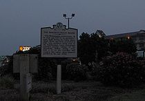
Between 1200 and 1500 A.D., during the Dallas Phase
of the Mississippian period
, a group of Native Americans established a relatively large village centered around a temple mound
just above the confluence of the West Fork and the Little Pigeon River. This mound was approximately 16 feet (5 m) high and 240 feet (73.2 m) across and was surrounded by a palisade
. An excavation in 1881 unearthed burials, arrow-points, a marble pipe, glass beads, pottery, and engraved objects. At the time of this first excavation, the mound was located on a farm owned by the McMahan family, and was thus given the name "McMahan Indian Mound".
By the early 18th century, the Cherokee
controlled much of the Tennessee side of the Smokies, establishing a series of settlements along the Little Tennessee River
. A section of the Great Indian Warpath
forked at the mouth of Boyd's Creek, just north of Sevierville. The main branch crossed the French Broad and continued along Dumplin Creek to the Nolichucky
basin in northeastern Tennessee. The other branch, known as the Tuckaleechee and Southeastern Trail, turned south along the West Fork of the Little Pigeon River. This second branch forked again at modern-day Pigeon Forge, with the main trail turning east en route to Little River
and the other branch, known as the Indian Gap Trail, crossing the crest of the Smokies to the south and descending into the Oconaluftee
area of North Carolina. The various Cherokee trails criss-crossing Sevier Co. brought the first Euro-American traders and settlers to the area.
 European long hunters
and traders arrived in the Sevierville area in the mid-18th century. Isaac Thomas (1735?-1818), the most notable of these early traders, was well respected by the Cherokee, and may have lived at the Overhill
town of Chota
at one time. Europeans like Thomas were mainly in search of animal furs, for which they exchanged manufactured goods.
As settlers began to trickle into East Tennessee, relations with the Cherokee began to turn hostile. During the Revolutionary War
, the Cherokee, who had aligned themselves with the British, launched sporadic attacks against the sparse settlements in the Tennessee Valley. In December 1780, Col. John Sevier
, fresh off a victory over the British at King's Mountain, launched a punitive expedition
against the Cherokee. Sevier routed the Cherokee at the Battle of Boyd's Creek and proceeded to destroy several Cherokee settlements along the Little Tennessee.
A temporary truce secured by James White
in 1783 led to an influx of Euro-American settlers in the French Broad valley. Hugh Henry (1756–1838) erected a small fort near the mouth of Dumplin Creek in 1782 known as Henry's Station. He was joined the following year by Samuel Newell (1754–1841), who established Newell's Station along Boyd's Creek, and Joshua Gist, who settled near the creek's mouth. Other early forts in the area included Willson's Station at the confluence of the East and Middle Fork of the Little Pigeon and Wear's Fort at the junction of the Southeastern and Tuckaleechee Trail and Indian Gap Trail. The Cherokee signed away all rights to what is now Sevier County in the 1785 Treaty of Dumplin, which was negotiated at Henry's Station.
In 1783, Isaac Thomas established a farm, trading post, and tavern at the confluence of the West Fork and the Little Pigeon River. He was joined shortly thereafter by Spencer Clack (1740–1832) and James McMahan, and a community known as "Forks of the Little Pigeon" developed around them. In 1789, Reverend Richard Wood (1756–1831) established Forks-of-the-River Baptist Church, which reported a congregation of 22 in 1790. By 1795, the congregation had 94 members.
 Sevier County was created in 1794 and named after John Sevier. At a meeting at Thomas's house the following year, the Forks-of-the-Little-Pigeon area was chosen as the county seat, and renamed "Sevierville." James McMahan donated a 25 acres (101,171.5 m²) tract upon which to erect a townsquare. This tract was parceled out into lots of 0.5 acres (2,023.4 m²) upon which the purchaser was required to build a brick, framed, or stone
structure.
The first Sevier County Courthouse was built in 1796. Before its construction, according to local legend, court was held in a flea-infested abandoned stable. Irritated lawyers were said to have paid an unknown person "a bottle of whiskey" to burn down the stable, forcing the new county to build an actual courthouse.
As the county grew, several large farms were established in the fertile Boyd's Creek area. In 1792, Andrew Evans purchased a tract of land near the mouth of Boyd's Creek and built a ferry near the site of the old ford. In 1798, Evans sold the farm to John Brabson, and it was henceforth known as the Brabson's Ferry Plantation
. In the early 1790s, Thomas Buckingham established a large farm between Boyd's Creek and Sevierville. Buckingham went on to become the county's first sheriff. In the early 19th century, Timothy Chandler and his son John Chandler (1786–1875) established the Wheatlands
plantation in Boyds Creek.
As towns situated along the French Broad are connected via waterway to New Orleans, a flatboat
trade flourished along the river in the early 19th century. In 1793, James Hubbert, who lived along Dumplin Creek, established Hubbert's Flat Landing to trade with flatboats moving up and down the river.
In the early 19th century, Knoxville and Asheville were connected via Route 17, a crude road which followed the banks of the French Broad. This new road gave Tennessee's cattle drovers greater access to markets along the east coast. In 1820, a stagecoach road connected Sevierville with Maryville to the west. Sevierville's situation as a county seat along these early roads helped it to grow. By 1833, the town had a population of 150, including two doctors, two carpenters, a tanner, two tailors, a shoemaker, three stores, a hatter, two taverns, and two mills. Distilleries were popular means of supplemental income. By 1850, John Chandler's distillery was producing 6,000 gallons of whiskey per year.
A notable late arrival in Sevierville was Dr. Robert Hodsden (1806–1864), who had been an attending physician for Cherokee Removal (Trail of Tears
). In 1846, Hodsden began construction on a plantation near Fair Garden, just outside of Sevierville to the east. This plantation, known as Rose Glen
, was worth $28,000 in 1860, one of the most valuable in the county.
In 1856, a fire swept through Sevierville, burning a recently-constructed new courthouse, 41 houses, and several shops in the downtown area. Perhaps more importantly, the county lost nearly all of the vital records of its early settlers.
In late 1861, a pro-secession speech delivered by Henry Foote met with an angry response in Sevierville, and was followed by a series of explosive anti-secession speeches. The following year, pro-Union Knoxville newspaper editor Parson Brownlow gave a rousing anti-secession speech in Sevierville en route to a hide out in Wears Valley
. Brownlow's audience remained gathered throughout the night after a (false) rumor spread that Confederate forces were approaching. Union
supporters in Sevier County were harassed and threatened throughout the war, even after Union forces under Ambrose Burnside
occupied Knoxville in September 1863.
Sevierville, situated at a major crossroads south of Knoxville, suffered consistent harassment, looting, and confiscation of property by both Union and Confederate
forces moving through the town in 1863 and 1864. Vance Newman, a Union recruiting officer living in Sevierville at the time, later recalled:
After Confederate General James Longstreet
failed to retake Knoxville in the Battle of Fort Sanders
, Union and Confederate forces quickly initiated a series of maneuvers to gain control of the strategic fords along the French Broad, culminating in an engagement near Hodsden's farm at Fair Garden in January 1864. Although the Union forces were victorious, they were later forced to retreat for lack of supplies. A state of general anarchy ensued, continuing until the end of the war. On October 30, 1864, Sevierville resident Terressa McCown wrote in her diary:
At the war's end, the county's few remaining Confederate sympathizers, most notably members of the Brabson family, were forced to flee.
 Sevierville recovered quickly from the war, with a number of new houses and businesses being built in the 1870s. Two members of the town's African-American community — house builder Lewis Buckner
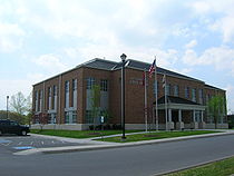
(1856–1924) and brickmason Isaac Dockery (1832–1910) — would play a prominent role in Sevierville's post-war construction boom. Buckner designed a number of houses in the Sevierville area over a 40-year period, 15 of which still stand. Dockery's greatest contributions include the New Salem Baptist Church in 1886 and the Sevier County Courthouse in 1896, both of which still stand.
By the 1880s, Sevierville was growing rapidly as the population of Sevier County swelled. In 1887, the town had four general stores, two groceries, a jeweler, a sawmill, and two hotels. It was also home to the Sevierville Lumber Company, which had recently been established to harvest trees in the area. Tourists also started to trickle into Sevier County, drawn by the health-restoring qualities of mountain springs. Resorts sprang up throughout the county, with Seaton Springs and Henderson Springs located just south of Sevierville.
In 1892, a vigilante group known as the "Whitecaps" was formed to rid Sevier County of vice. The group wore white hoods to conceal their identities and used Ku Klux Klan
-like tactics, although they weren't considered a racist entity. While the Whitecaps initially threatened women accused of prostitution, the group quickly spiraled out of control, launching nightly attacks in the mid-1890s. In 1893, Sevierville physician J.A. Henderson took over an anti-Whitecap group, which he renamed the "Blue Bills." The two vigilante groups clashed at Henderson Springs in 1894, with deaths on both sides. In 1896, the Whitecaps' murder of a young Sevierville couple led to widespread outrage, and in 1898, the Tennessee State Legislature banned "extra-legal conspiracies" and vigilante groups. Due to this measure and the efforts of Sevier County Deputy Sheriff Thomas Davis, the Whitecaps had largely vanished by the end of the century.
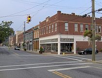 After a fire destroyed much of the downtown area in 1900, businesses shifted from the old town square at Main Street to the new Sevierville Commercial District, viz. Court Avenue and Bruce Street, which was centered around the new courthouse. The town incorporated in 1901.
In 1910, Indiana entrepreneur William J. Oliver finished work on the Knoxville, Sevierville and Eastern Railroad, which was Sevier County's first standard gauge
rail line. Known as the Smoky Mountain Railroad
, this line offered passenger service between Knoxville and Sevierville until 1962.
With the opening of the Great Smoky Mountains National Park in 1934, tens of thousands of tourists began passing through Sevierville, which was situated about halfway between the park and Knoxville. US-441, initially known as the Smoky Mountain Highway, was completed to Sevierville in 1934, and later extended to North Carolina.
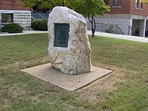
Entertainer Dolly Parton
was born in Sevierville in 1946. The Parton family migrated to Greenbrier
sometime around 1850, and later moved to Locust Ridge (near Pittman Center) after establishment of the national park. Parton has been honored with the Dolly Parton Parkway being named for her and with a statue on the lawn of the Sevierville courthouse.
and motel
rooms in the city today, generating more than $500,000(USD) in hotel-motel tax revenues each year.
East Tennessee Radio Group owns and operates the Sevierville area's primary local radio stations, WPFT
-FM "106.3 THE MOUNTAIN" (Classic hits of the 1960s and 1970s, now sports talk) and FM 105.5 (adult contemporary music, known as "Mix 105.5"). Also, WWST
-FM "Star" 102.1, a Top 40 music station serving the Knoxville market, is licensed by the Federal Communications Commission
(FCC) to Sevierville.
Sevierville is also home to the following private institutions:
In addition to the preceding institutions, Sevierville is home to the Sevier County satellite campus of Walters State Community College
, based in Morristown, Tennessee
. King College
, based in Bristol, Tennessee
also operates a satellite campus in Sevierville at the Walters State Community College location.
Sevier County, Tennessee
Sevier County is a county of the state of Tennessee, United States. Its population was 71,170 at the 2000 United States Census. It is included in the Sevierville, Tennessee, Micropolitan Statistical Area, which is included in the Knoxville-Sevierville-La Follette, TN Combined Statistical Area. The...
, located in the Southeastern United States. Its population
Population
A population is all the organisms that both belong to the same group or species and live in the same geographical area. The area that is used to define a sexual population is such that inter-breeding is possible between any pair within the area and more probable than cross-breeding with individuals...
was 11,757 at the 2000 United States Census
United States Census, 2000
The Twenty-second United States Census, known as Census 2000 and conducted by the Census Bureau, determined the resident population of the United States on April 1, 2000, to be 281,421,906, an increase of 13.2% over the 248,709,873 persons enumerated during the 1990 Census...
; in 2004 the estimated population was 14,101. Sevierville is the county seat
County seat
A county seat is an administrative center, or seat of government, for a county or civil parish. The term is primarily used in the United States....
of Sevier County, Tennessee
Sevier County, Tennessee
Sevier County is a county of the state of Tennessee, United States. Its population was 71,170 at the 2000 United States Census. It is included in the Sevierville, Tennessee, Micropolitan Statistical Area, which is included in the Knoxville-Sevierville-La Follette, TN Combined Statistical Area. The...
.
Geography
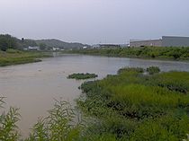
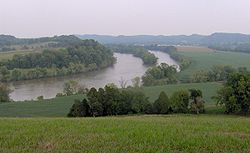
Sevierville is located at 35°52′39"N 83°34′12"W (35.877560, -83.569927). In the town's eastern section, the Little Pigeon RiverLittle Pigeon River (Tennessee)
The Little Pigeon River is a river located entirely within Sevier County, Tennessee.It rises from a series of streams which flow together on the dividing ridge between the states of Tennessee and North Carolina inside the boundary of the Great Smoky Mountains National Park. The river is subdivided...
is formed by the confluence of its East Fork and Middle Fork, both of which flow down from their sources high in the Great Smoky Mountains
Great Smoky Mountains
The Great Smoky Mountains are a mountain range rising along the Tennessee–North Carolina border in the southeastern United States. They are a subrange of the Appalachian Mountains, and form part of the Blue Ridge Physiographic Province. The range is sometimes called the Smoky Mountains or the...
. Five miles (8 km) downstream to the west, the Little Pigeon absorbs its West Fork before turning north and flowing for another five miles (8 km) to its mouth along the French Broad River
French Broad River
The French Broad River flows from near the village of Rosman in Transylvania County, North Carolina, into the state of Tennessee. Its confluence with the Holston River at Knoxville is the beginning of the Tennessee River....
. Sevierville is centered around the stretch of land between these two junctions of the East and Middle Fork and the West Fork, known traditionally as Forks-of-the-Pigeon or Forks-of-the-River.
Tennessee Valley
The Tennessee Valley is the drainage basin of the Tennessee River and is largely within the U.S. state of Tennessee. It stretches from southwest Kentucky to northwest Georgia and from northeast Mississippi to the mountains of Virginia and North Carolina...
, Sevierville has long acted as a nexus between Knoxville
Knoxville, Tennessee
Founded in 1786, Knoxville is the third-largest city in the U.S. state of Tennessee, U.S.A., behind Memphis and Nashville, and is the county seat of Knox County. It is the largest city in East Tennessee, and the second-largest city in the Appalachia region...
to the north and the Appalachia
Appalachia
Appalachia is a term used to describe a cultural region in the eastern United States that stretches from the Southern Tier of New York state to northern Alabama, Mississippi, and Georgia. While the Appalachian Mountains stretch from Belle Isle in Canada to Cheaha Mountain in the U.S...
n towns in the mountains to the south. The Great Smoky Mountains National Park
Great Smoky Mountains National Park
Great Smoky Mountains National Park is a United States National Park and UNESCO World Heritage Site that straddles the ridgeline of the Great Smoky Mountains, part of the Blue Ridge Mountains, which are a division of the larger Appalachian Mountain chain. The border between Tennessee and North...
is located approximately ten miles south of Sevierville.
Due to its hilly terrain and the relatively poor roads of 19th-century Sevier County, a number of smaller communities developed independently along the outskirts of Sevierville. These include Harrisburg and Fair Garden to the east and Catlettsburg and Boyd's Creek to the north. In addition, the United States Postal Service
United States Postal Service
The United States Postal Service is an independent agency of the United States government responsible for providing postal service in the United States...
associates the name "Sevierville" with ZIP codes for much of Sevier County, including the town of Pittman Center and other geographically extensive areas located outside Sevierville's city limits.
Several major state and federal highways intersect in Sevierville. U.S. Route 441
U.S. Route 441
U.S. Route 441 is a spur route of U.S. Route 41. It currently runs for 939 miles from U.S. Route 41 in Miami, Florida to U.S. Route 25W in Lake City, Tennessee. Between its termini, US 441 passes through the states of Florida, Georgia, North Carolina, and Tennessee...
, commonly called "The Parkway," connects Sevierville with Knoxville to the north and the national park and Cherokee, North Carolina
Cherokee, North Carolina
Cherokee is a town in Swain County, North Carolina, USA, within the Qualla Boundary land trust. It is located in the Oconaluftee River Valley, near the intersection of U.S. Route 19 and U.S...
to the south. The Sevierville section of US-441 has been named "Forks-of-the-River Parkway." State Route 66
Tennessee State Route 66
State Route 66 is a state-maintained highway in eastern Tennessee, including a four-lane divided highway segment in Sevier County and a two-lane segment through mountainous terrain to the northeast.- Route description :...
, also called Winfield Dunn Parkway, connects Sevierville with Interstate 40
Interstate 40
Interstate 40 is the third-longest major east–west Interstate Highway in the United States, after I-90 and I-80. Its western end is at Interstate 15 in Barstow, California; its eastern end is at a concurrency of U.S. Route 117 and North Carolina Highway 132 in Wilmington, North Carolina...
to the north. U.S. Route 411
U.S. Route 411
U.S. Highway 411 is an alternate parallel-highway associated with U.S. Highway 11. U.S. 411 extends for about 313 miles from U.S. Route 78 in Leeds, Jefferson County, Alabama, to U.S. Highway 25 in Newport, Cocke County, Tennessee. U.S. 411 passes through the northeastern State of Alabama, the...
traverses Sevierville from east to west, connecting Sevierville with Blount County
Blount County, Tennessee
Blount County is a U.S. county located in the U.S. state of Tennessee. Its population was 123,010 at the United States Census, 2010. The county seat is at Maryville, which is also the county's largest city....
and Cocke County. State Route 416 connects Sevierville with Pittman Center and U.S. Route 321
U.S. Route 321
U.S. Route 321 is a spur of U.S. Route 21. It runs for 526 miles from South Carolina to Tennessee. The northern terminus of U.S. 321 is between Lenoir City and Oak Ridge, Tennessee, at Interstate 40 exit 364, which is about 4 miles west of Interstate 40's junction with Interstate 75...
at the park boundary to the southeast.
According to the United States Census Bureau
United States Census Bureau
The United States Census Bureau is the government agency that is responsible for the United States Census. It also gathers other national demographic and economic data...
, the city has a total area of 20 square miles (51.8 km²), of which, 19.9 square miles (51.5 km²) of it is land and 0.1 square mile (0.258998811 km²) of it (0.50%) is water.
Demographics
Census
A census is the procedure of systematically acquiring and recording information about the members of a given population. It is a regularly occurring and official count of a particular population. The term is used mostly in connection with national population and housing censuses; other common...
of 2000, there were 11,757 people, 5,002 households, and 3,206 families residing in the city. The population density
Population density
Population density is a measurement of population per unit area or unit volume. It is frequently applied to living organisms, and particularly to humans...
was 591.1 people per square mile (228.2/km²). There were 5,787 housing units at an average density of 291.0 per square mile (112.3/km²). The racial makeup of the city was 95.64% White, 1.17% African American, 0.37% Native American, 0.93% Asian, 0.02% Pacific Islander, 0.73% from other races
Race (United States Census)
Race and ethnicity in the United States Census, as defined by the Federal Office of Management and Budget and the United States Census Bureau, are self-identification data items in which residents choose the race or races with which they most closely identify, and indicate whether or not they are...
, and 1.16% from two or more races. Hispanic or Latino of any race were 1.62% of the population.
There were 5,002 households out of which 28.5% had children under the age of 18 living with them, 47.3% were married couples
Marriage
Marriage is a social union or legal contract between people that creates kinship. It is an institution in which interpersonal relationships, usually intimate and sexual, are acknowledged in a variety of ways, depending on the culture or subculture in which it is found...
living together, 13.2% had a female householder with no husband present, and 35.9% were non-families. 30.4% of all households were made up of individuals and 12.2% had someone living alone who was 65 years of age or older. The average household size was 2.27 and the average family size was 2.82.
In the city the population was spread out with 22.1% under the age of 18, 9.8% from 18 to 24, 28.9% from 25 to 44, 23.2% from 45 to 64, and 16.0% who were 65 years of age or older. The median age was 37 years. For every 100 females there were 89.0 males. For every 100 females age 18 and over, there were 84.2 males.
The median income for a household in the city was $30,623, and the median income for a family was $37,972. Males had a median income of $27,247 versus $19,401 for females. The per capita income
Per capita income
Per capita income or income per person is a measure of mean income within an economic aggregate, such as a country or city. It is calculated by taking a measure of all sources of income in the aggregate and dividing it by the total population...
for the city was $18,576. About 14.5% of families and 16.9% of the population were below the poverty line, including 24.1% of those under age 18 and 17.2% of those age 65 or over.
Sevierville is the principal city of the Sevierville, Tennessee Micropolitan Statistical Area which includes all of Sevier County and is a component of the Knoxville-Sevierville-La Follette
Knoxville Metropolitan Area
Knoxville Metropolitan Area is the third largest Metropolitan Statistical Area in Tennessee. It consists of Knoxville, Tennessee as its central city and the following counties:*Anderson*Blount*Knox*Loudon*Union...
Combined Statistical Area
Combined Statistical Area
The United States Office of Management and Budget defines micropolitan and metropolitan statistical areas. Metropolitan and micropolitan statistical areas consist of one or more counties...
.
History
Woodland period
The Woodland period of North American pre-Columbian cultures was from roughly 1000 BCE to 1000 CE in the eastern part of North America. The term "Woodland Period" was introduced in the 1930s as a generic header for prehistoric sites falling between the Archaic hunter-gatherers and the...
were among the first human inhabitants of what is now Sevierville, arriving sometime around 200 A.D. and living in villages scattered around the Forks-of-the-River area.
Between 1200 and 1500 A.D., during the Dallas Phase
Dallas Phase
Dallas Phase is an archaeological phase, within the Mississippian III period, in the South Appalachian Geologic province.-Geography:Dallas peoples moved into southwest Virginia from northeastern Tennessee in the early 13th century...
of the Mississippian period
Mississippian culture
The Mississippian culture was a mound-building Native American culture that flourished in what is now the Midwestern, Eastern, and Southeastern United States from approximately 800 CE to 1500 CE, varying regionally....
, a group of Native Americans established a relatively large village centered around a temple mound
Platform mound
A platform mound is any earthwork or mound intended to support a structure or activity.-Eastern North America:The indigenous peoples of North America built substructure mounds for well over a thousand years starting in the Archaic period and continuing through the Woodland period...
just above the confluence of the West Fork and the Little Pigeon River. This mound was approximately 16 feet (5 m) high and 240 feet (73.2 m) across and was surrounded by a palisade
Palisade
A palisade is a steel or wooden fence or wall of variable height, usually used as a defensive structure.- Typical construction :Typical construction consisted of small or mid sized tree trunks aligned vertically, with no spacing in between. The trunks were sharpened or pointed at the top, and were...
. An excavation in 1881 unearthed burials, arrow-points, a marble pipe, glass beads, pottery, and engraved objects. At the time of this first excavation, the mound was located on a farm owned by the McMahan family, and was thus given the name "McMahan Indian Mound".
By the early 18th century, the Cherokee
Cherokee
The Cherokee are a Native American people historically settled in the Southeastern United States . Linguistically, they are part of the Iroquoian language family...
controlled much of the Tennessee side of the Smokies, establishing a series of settlements along the Little Tennessee River
Little Tennessee River
The Little Tennessee River is a tributary of the Tennessee River, approximately 135 miles long, in the Appalachian Mountains in the southeastern United States.-Geography:...
. A section of the Great Indian Warpath
Great Indian Warpath
The Great Indian Warpath — also known as the Great Indian War and Trading Path, or the Seneca Trail — was that part of the network of trails in eastern North America developed and used by Native Americans which ran through the Great Appalachian Valley...
forked at the mouth of Boyd's Creek, just north of Sevierville. The main branch crossed the French Broad and continued along Dumplin Creek to the Nolichucky
Nolichucky River
The Nolichucky River is a major stream draining the Blue Ridge Mountains of western North Carolina and east Tennessee. The river is long.-Hydrography:...
basin in northeastern Tennessee. The other branch, known as the Tuckaleechee and Southeastern Trail, turned south along the West Fork of the Little Pigeon River. This second branch forked again at modern-day Pigeon Forge, with the main trail turning east en route to Little River
Little River (Tennessee)
Little River is a scenic river in Tennessee which drains a area containing some of the most spectacular scenery in the southeastern United States. The first of the river are all located within the borders of the Great Smoky Mountains National Park...
and the other branch, known as the Indian Gap Trail, crossing the crest of the Smokies to the south and descending into the Oconaluftee
Oconaluftee (Great Smoky Mountains)
Oconaluftee is the name of a river valley in the Great Smoky Mountains of North Carolina, located in the Southeastern United States. Formerly the site of a Cherokee village and Appalachian community, the valley's bottomland is now home to the main entrance to the North Carolina section of the...
area of North Carolina. The various Cherokee trails criss-crossing Sevier Co. brought the first Euro-American traders and settlers to the area.
Early Euro-American settlement
Longhunter
A Longhunter was an 18th-century explorer and hunter who made expeditions into the American frontier wilderness for as much as six months at a time...
and traders arrived in the Sevierville area in the mid-18th century. Isaac Thomas (1735?-1818), the most notable of these early traders, was well respected by the Cherokee, and may have lived at the Overhill
Overhill Cherokee
The term Overhill Cherokee refers to the former Cherokee settlements located in what is now Tennessee in the southeastern United States. The name was given by 18th century European traders and explorers who had to cross the Appalachian Mountains to reach these settlements when traveling from...
town of Chota
Chota (Cherokee town)
Chota is a historic Overhill Cherokee site in Monroe County, Tennessee, in the southeastern United States. For much of its history, Chota was the most important of the Overhill towns, serving as the de facto capital of the Cherokee people from the late 1740s until 1788...
at one time. Europeans like Thomas were mainly in search of animal furs, for which they exchanged manufactured goods.
As settlers began to trickle into East Tennessee, relations with the Cherokee began to turn hostile. During the Revolutionary War
American Revolutionary War
The American Revolutionary War , the American War of Independence, or simply the Revolutionary War, began as a war between the Kingdom of Great Britain and thirteen British colonies in North America, and ended in a global war between several European great powers.The war was the result of the...
, the Cherokee, who had aligned themselves with the British, launched sporadic attacks against the sparse settlements in the Tennessee Valley. In December 1780, Col. John Sevier
John Sevier
John Sevier served four years as the only governor of the State of Franklin and twelve years as Governor of Tennessee. As a U.S. Representative from Tennessee from 1811 until his death...
, fresh off a victory over the British at King's Mountain, launched a punitive expedition
Punitive expedition
A punitive expedition is a military journey undertaken to punish a state or any group of persons outside the borders of the punishing state. It is usually undertaken in response to perceived disobedient or morally wrong behavior, but may be also be a covered revenge...
against the Cherokee. Sevier routed the Cherokee at the Battle of Boyd's Creek and proceeded to destroy several Cherokee settlements along the Little Tennessee.
A temporary truce secured by James White
James White (general)
James White was an American pioneer and soldier who founded Knoxville, Tennessee, in the early 1790s. Born in Rowan County, North Carolina, White served as a captain in the county's militia during the American Revolutionary War...
in 1783 led to an influx of Euro-American settlers in the French Broad valley. Hugh Henry (1756–1838) erected a small fort near the mouth of Dumplin Creek in 1782 known as Henry's Station. He was joined the following year by Samuel Newell (1754–1841), who established Newell's Station along Boyd's Creek, and Joshua Gist, who settled near the creek's mouth. Other early forts in the area included Willson's Station at the confluence of the East and Middle Fork of the Little Pigeon and Wear's Fort at the junction of the Southeastern and Tuckaleechee Trail and Indian Gap Trail. The Cherokee signed away all rights to what is now Sevier County in the 1785 Treaty of Dumplin, which was negotiated at Henry's Station.
In 1783, Isaac Thomas established a farm, trading post, and tavern at the confluence of the West Fork and the Little Pigeon River. He was joined shortly thereafter by Spencer Clack (1740–1832) and James McMahan, and a community known as "Forks of the Little Pigeon" developed around them. In 1789, Reverend Richard Wood (1756–1831) established Forks-of-the-River Baptist Church, which reported a congregation of 22 in 1790. By 1795, the congregation had 94 members.
Antebellum Sevierville
structure.
The first Sevier County Courthouse was built in 1796. Before its construction, according to local legend, court was held in a flea-infested abandoned stable. Irritated lawyers were said to have paid an unknown person "a bottle of whiskey" to burn down the stable, forcing the new county to build an actual courthouse.
As the county grew, several large farms were established in the fertile Boyd's Creek area. In 1792, Andrew Evans purchased a tract of land near the mouth of Boyd's Creek and built a ferry near the site of the old ford. In 1798, Evans sold the farm to John Brabson, and it was henceforth known as the Brabson's Ferry Plantation
Brabson's Ferry Plantation
Brabson's Ferry Plantation is a Pioneer Century farm and former antebellum plantation near the U.S. city of Sevierville, Tennessee. Located at what was once a strategic crossing of the French Broad River, by 1860 the plantation had become one of the largest in East Tennessee, and one of the few in...
. In the early 1790s, Thomas Buckingham established a large farm between Boyd's Creek and Sevierville. Buckingham went on to become the county's first sheriff. In the early 19th century, Timothy Chandler and his son John Chandler (1786–1875) established the Wheatlands
Wheatlands (Sevierville, Tennessee)
Wheatlands was an antebellum plantation in Sevier County, in the U.S. state of Tennessee. The plantation's surviving structures— which include the plantation house, a storage shed, and smokehouse— have been placed on the National Register of Historic Places...
plantation in Boyds Creek.
As towns situated along the French Broad are connected via waterway to New Orleans, a flatboat
Flatboat
Fil1800flatboat.jpgA flatboat is a rectangular flat-bottomed boat with Fil1800flatboat.jpgA flatboat is a rectangular flat-bottomed boat with Fil1800flatboat.jpgA flatboat is a rectangular flat-bottomed boat with (mostlyNOTE: "(parenthesized)" wordings in the quote below are notes added to...
trade flourished along the river in the early 19th century. In 1793, James Hubbert, who lived along Dumplin Creek, established Hubbert's Flat Landing to trade with flatboats moving up and down the river.
In the early 19th century, Knoxville and Asheville were connected via Route 17, a crude road which followed the banks of the French Broad. This new road gave Tennessee's cattle drovers greater access to markets along the east coast. In 1820, a stagecoach road connected Sevierville with Maryville to the west. Sevierville's situation as a county seat along these early roads helped it to grow. By 1833, the town had a population of 150, including two doctors, two carpenters, a tanner, two tailors, a shoemaker, three stores, a hatter, two taverns, and two mills. Distilleries were popular means of supplemental income. By 1850, John Chandler's distillery was producing 6,000 gallons of whiskey per year.
A notable late arrival in Sevierville was Dr. Robert Hodsden (1806–1864), who had been an attending physician for Cherokee Removal (Trail of Tears
Trail of Tears
The Trail of Tears is a name given to the forced relocation and movement of Native American nations from southeastern parts of the United States following the Indian Removal Act of 1830...
). In 1846, Hodsden began construction on a plantation near Fair Garden, just outside of Sevierville to the east. This plantation, known as Rose Glen
Rose Glen (Sevierville, Tennessee)
Rose Glen was an antebellum plantation in Sevier County, in the U.S. state of Tennessee. At its height, Rose Glen was one of the largest and most lucrative farms in Sevier County, and one of the most productive in East Tennessee...
, was worth $28,000 in 1860, one of the most valuable in the county.
In 1856, a fire swept through Sevierville, burning a recently-constructed new courthouse, 41 houses, and several shops in the downtown area. Perhaps more importantly, the county lost nearly all of the vital records of its early settlers.
The Civil War
Slavery wasn't common in Sevier County, although it did occur, especially at the large plantations along the French Broad River. Even before the war, Sevierville, a hotbed of abolitionist activity, was home to a relatively large community of free African-Americans. In 1861, only 3.8% of Sevier Countians voted in favor of secession from the Union.In late 1861, a pro-secession speech delivered by Henry Foote met with an angry response in Sevierville, and was followed by a series of explosive anti-secession speeches. The following year, pro-Union Knoxville newspaper editor Parson Brownlow gave a rousing anti-secession speech in Sevierville en route to a hide out in Wears Valley
Wears Valley, Tennessee
Wears Valley is an unincorporated area in Sevier County, Tennessee, treated by the U.S. Census Bureau as a census county division. As of the 2000 Census, the population of Wears Valley was 6,486....
. Brownlow's audience remained gathered throughout the night after a (false) rumor spread that Confederate forces were approaching. Union
Union (American Civil War)
During the American Civil War, the Union was a name used to refer to the federal government of the United States, which was supported by the twenty free states and five border slave states. It was opposed by 11 southern slave states that had declared a secession to join together to form the...
supporters in Sevier County were harassed and threatened throughout the war, even after Union forces under Ambrose Burnside
Ambrose Burnside
Ambrose Everett Burnside was an American soldier, railroad executive, inventor, industrialist, and politician from Rhode Island, serving as governor and a U.S. Senator...
occupied Knoxville in September 1863.
Sevierville, situated at a major crossroads south of Knoxville, suffered consistent harassment, looting, and confiscation of property by both Union and Confederate
Confederate States of America
The Confederate States of America was a government set up from 1861 to 1865 by 11 Southern slave states of the United States of America that had declared their secession from the U.S...
forces moving through the town in 1863 and 1864. Vance Newman, a Union recruiting officer living in Sevierville at the time, later recalled:
A guard of rebel soldiers in 1864 threatened to burn my house, and the rebel soldiers so often threatened to take my life that I cannot particularize. They were always after me because of my Union sentiments.
After Confederate General James Longstreet
James Longstreet
James Longstreet was one of the foremost Confederate generals of the American Civil War and the principal subordinate to General Robert E. Lee, who called him his "Old War Horse." He served under Lee as a corps commander for many of the famous battles fought by the Army of Northern Virginia in the...
failed to retake Knoxville in the Battle of Fort Sanders
Battle of Fort Sanders
The Battle of Fort Sanders was the decisive engagement of the Knoxville Campaign of the American Civil War, fought in Knoxville, Tennessee, on November 29, 1863. Assaults by Confederate Lt. Gen. James Longstreet failed to break through the defensive lines of Union Maj. Gen...
, Union and Confederate forces quickly initiated a series of maneuvers to gain control of the strategic fords along the French Broad, culminating in an engagement near Hodsden's farm at Fair Garden in January 1864. Although the Union forces were victorious, they were later forced to retreat for lack of supplies. A state of general anarchy ensued, continuing until the end of the war. On October 30, 1864, Sevierville resident Terressa McCown wrote in her diary:
The robbers have come at last, they robbed my husband of his pocketbook, money and papers and pocket knife. Times get worse everyday. We know not what will come next. I feel this morning like nothing but destruction awaits us.
At the war's end, the county's few remaining Confederate sympathizers, most notably members of the Brabson family, were forced to flee.
1880-present
Lewis Buckner
Lewis Buckner was an American house builder and carpenter. Born and raised a slave, Buckner went on to become one of several successful African-American construction entrepreneurs in late-19th century Sevier County, Tennessee...
(1856–1924) and brickmason Isaac Dockery (1832–1910) — would play a prominent role in Sevierville's post-war construction boom. Buckner designed a number of houses in the Sevierville area over a 40-year period, 15 of which still stand. Dockery's greatest contributions include the New Salem Baptist Church in 1886 and the Sevier County Courthouse in 1896, both of which still stand.
By the 1880s, Sevierville was growing rapidly as the population of Sevier County swelled. In 1887, the town had four general stores, two groceries, a jeweler, a sawmill, and two hotels. It was also home to the Sevierville Lumber Company, which had recently been established to harvest trees in the area. Tourists also started to trickle into Sevier County, drawn by the health-restoring qualities of mountain springs. Resorts sprang up throughout the county, with Seaton Springs and Henderson Springs located just south of Sevierville.
In 1892, a vigilante group known as the "Whitecaps" was formed to rid Sevier County of vice. The group wore white hoods to conceal their identities and used Ku Klux Klan
Ku Klux Klan
Ku Klux Klan, often abbreviated KKK and informally known as the Klan, is the name of three distinct past and present far-right organizations in the United States, which have advocated extremist reactionary currents such as white supremacy, white nationalism, and anti-immigration, historically...
-like tactics, although they weren't considered a racist entity. While the Whitecaps initially threatened women accused of prostitution, the group quickly spiraled out of control, launching nightly attacks in the mid-1890s. In 1893, Sevierville physician J.A. Henderson took over an anti-Whitecap group, which he renamed the "Blue Bills." The two vigilante groups clashed at Henderson Springs in 1894, with deaths on both sides. In 1896, the Whitecaps' murder of a young Sevierville couple led to widespread outrage, and in 1898, the Tennessee State Legislature banned "extra-legal conspiracies" and vigilante groups. Due to this measure and the efforts of Sevier County Deputy Sheriff Thomas Davis, the Whitecaps had largely vanished by the end of the century.
In 1910, Indiana entrepreneur William J. Oliver finished work on the Knoxville, Sevierville and Eastern Railroad, which was Sevier County's first standard gauge
Standard gauge
The standard gauge is a widely-used track gauge . Approximately 60% of the world's existing railway lines are built to this gauge...
rail line. Known as the Smoky Mountain Railroad
Smoky Mountain Railroad
The Smoky Mountain Railroad was a short standard gauge rail line that ran from Knoxville, Tennessee to Sevierville, Tennessee from 1910 until 1962....
, this line offered passenger service between Knoxville and Sevierville until 1962.
With the opening of the Great Smoky Mountains National Park in 1934, tens of thousands of tourists began passing through Sevierville, which was situated about halfway between the park and Knoxville. US-441, initially known as the Smoky Mountain Highway, was completed to Sevierville in 1934, and later extended to North Carolina.
Entertainer Dolly Parton
Dolly Parton
Dolly Rebecca Parton is an American singer-songwriter, author, multi-instrumentalist, actress and philanthropist, best known for her work in country music. Dolly Parton has appeared in movies like 9 to 5, The Best Little Whorehouse in Texas, Steel Magnolias and Straight Talk...
was born in Sevierville in 1946. The Parton family migrated to Greenbrier
Greenbrier (Great Smoky Mountains)
Greenbrier is a valley in the northern Great Smoky Mountains of Tennessee, located in the Southeastern United States. Now a recreational area, Greenbrier was once home to a string of Appalachian communities....
sometime around 1850, and later moved to Locust Ridge (near Pittman Center) after establishment of the national park. Parton has been honored with the Dolly Parton Parkway being named for her and with a statue on the lawn of the Sevierville courthouse.
Economy
Like other towns situated along the Parkway in Sevier County, Sevierville has reaped the benefits of the burgeoning tourism industry brought on by the development of the Great Smoky Mountains National Park. As of 2004, nearly fifty percent of businesses based in Sevierville were linked to tourism. For example, there are over 2,000 hotelHotel
A hotel is an establishment that provides paid lodging on a short-term basis. The provision of basic accommodation, in times past, consisting only of a room with a bed, a cupboard, a small table and a washstand has largely been replaced by rooms with modern facilities, including en-suite bathrooms...
and motel
Motel
A motor hotel, or motel for short, is a hotel designed for motorists, and usually has a parking area for motor vehicles...
rooms in the city today, generating more than $500,000(USD) in hotel-motel tax revenues each year.
East Tennessee Radio Group owns and operates the Sevierville area's primary local radio stations, WPFT
WPFT
WPFT is a sports talk radio station licensed to Pigeon Forge, Tennessee. Owned by East Tennessee Radio Group, L.P., WPFT serves the Knoxville, Tennessee area. WPFT is an affiliate of the Atlanta Braves....
-FM "106.3 THE MOUNTAIN" (Classic hits of the 1960s and 1970s, now sports talk) and FM 105.5 (adult contemporary music, known as "Mix 105.5"). Also, WWST
WWST
WWST is a radio station licensed to Sevierville, Tennessee, and serving the Knoxville market. It is owned by the Journal Broadcast Group...
-FM "Star" 102.1, a Top 40 music station serving the Knoxville market, is licensed by the Federal Communications Commission
Federal Communications Commission
The Federal Communications Commission is an independent agency of the United States government, created, Congressional statute , and with the majority of its commissioners appointed by the current President. The FCC works towards six goals in the areas of broadband, competition, the spectrum, the...
(FCC) to Sevierville.
Education
Sevierville is served by the Sevier County public school system. The educational system in Sevierville consists of the following public institutions:- Elementary-Grammar level:
- Sevierville Primary School - Grades: Kindergarten-Second, Enrollment: 737
- Sevierville Intermediate School - Grades: Third-Fifth, Enrollment: 699
- T. Lawson Early Childhood - Grades: Pre-Kindergarten—Kindergarten, Enrollment: 21
- Elementary-Grammar/Junior High level:
- Catons Chapel Elementary School - Grades: Kindergarten-Eighth, Enrollment: 397
- New Center Elementary School - Grades: Kindergarten-Eighth, Enrollment: 748
- Wearwood Elementary School - Grades: Kindergarten-Eighth, Enrollment: 226
- Junior High level:
- Sevierville Middle School - Grades: Sixth-Eighth, Enrollment: 722
- Junior High/Secondary level:
- Hardin Alternative Learning Center - Grades: Seventh-Twelfth, Enrollment: 36
- Parkway Academy - Grades: Sixth-Twelfth, Enrollment: 41
- Secondary level:
- Sevier County High School - Grades: Ninth-Twelfth
Sevierville is also home to the following private institutions:
- Elementary-Grammar level:
- Riverside Academy - Grades: Pre-Kindergarten—Fourth, Enrollment: 35
- Elementary-Grammar/Junior High/Secondary level:
- Covenant Christian Academy - Grades: Pre-Kindergarten—Twelfth, Enrollment: 450
- St. Andrew's SchoolSt. Andrew's School (Sevierville, Tennessee)St. Andrew's School in Sevierville, Tennessee is a co-educational, private Christian boarding school which enrolls fewer than thirty students in kindergarten through grade twelve....
- Grades: Third-Twelfth, Enrollment: 26
- Ungraded:
- New Center Christian School - Enrollment: 11
In addition to the preceding institutions, Sevierville is home to the Sevier County satellite campus of Walters State Community College
Walters State Community College
Walters State Community College is a state-supported community college operated by the Tennessee Board of Regents. It was established in 1970 in located Morristown, Tennessee and was named in honor of former United States Senator Herbert S...
, based in Morristown, Tennessee
Morristown, Tennessee
Morristown is a city in, and the county seat of, Hamblen County, Tennessee, United States. The population was 29,137 at the 2010 United States Census. It is the principal city of the Morristown, Tennessee Metropolitan Statistical Area, which encompasses all of Grainger, Hamblen and Jefferson counties...
. King College
King College
King College is a private, comprehensive college located in Bristol, Tennessee. Founded in 1867, King is independently governed with covenant affiliations to the Presbyterian Church and the Evangelical Presbyterian Church ....
, based in Bristol, Tennessee
Bristol, Tennessee
Bristol is a city in Sullivan County, Tennessee, United States. The population was 26,702 at the 2010 census. It is the twin city of Bristol, Virginia, which lies directly across the state line between Tennessee and Virginia. The boundaries of both cities run parallel to each other along State...
also operates a satellite campus in Sevierville at the Walters State Community College location.
Points of interest
- Burchfield Grove Memorial Arboretum
- Tennessee Museum of Aviation
Registered historic sites
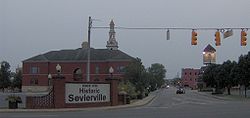
- The Sevier County Courthouse, completed in 1896. Sevier County's fifth courthouse. The building was designed by the McDonald Brothers of LouisvilleLouisville, KentuckyLouisville is the largest city in the U.S. state of Kentucky, and the county seat of Jefferson County. Since 2003, the city's borders have been coterminous with those of the county because of a city-county merger. The city's population at the 2010 census was 741,096...
and constructed by C.W. Brown of Lenoir CityLenoir City, TennesseeLenoir City is a city in Loudon County, Tennessee, United States. Its population was 8,642 at the 2010 census. It is included in the Knoxville Metropolitan Area....
. The brickwork was completed by Isaac Dockery. Added to the National Register of Historic PlacesNational Register of Historic PlacesThe National Register of Historic Places is the United States government's official list of districts, sites, buildings, structures, and objects deemed worthy of preservation...
in 1971.
- The Sevierville Commercial District, which includes Court Avenue, Bruce Street, and Commerce Street, all in the vicinity of the courthouse. Sevierville's commercial district shifted to this part of town when the old commercial district burned in the early 20th century. Added to the National Register of Historic Places in 1986.
- Buckingham House between Sevierville and Boyd's Creek, built late 18th century by Thomas Buckingham. Added to the National Register of Historic Places in 1971.
- Brabson's Ferry Plantation, near Boyd's Creek; established by Andrew Evans in early 1790s and purchased by John Brabson in 1798. The site includes a plank house from the late 18th century. Added to the National Register of Historic Places in 1975.
- Wheatlands, near Boyd's Creek. This house was built in the early 19th century by John Chandler, who owned a large plantation and distillery. Added to the National Register of Historic Places in 1975.
- Rose Glen, near Fair Garden. This house was built in the 1840s by Dr. Robert Hodsden. Added to the National Register of Historic Places in 1975.
- New Salem Baptist Church, built in the 1880s by the local African-American community, including brickwork by Isaac Dockery. Added to the National Register of Historic Places in 2003.
- The Harrisburg Covered Bridge, built in the late 1880s. Added to the National Register of Historic Places in 1975.