

Florida Scenic Highways
Encyclopedia
Federally designated scenic byways
| Name | Image | From | To | Highways | Notes |
|---|---|---|---|---|---|
| A1A Scenic and Historic Coastal Byway | 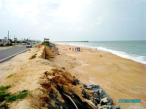 |
Marineland Marineland, Florida Marineland is a town in both Flagler and St. Johns counties, in Florida, United States. The population was six at the 2000 census. As of 2004, the population recorded by the U.S. Census Bureau is ten . Marineland is located south of St... |
Ponte Vedra Beach Ponte Vedra Beach, Florida Ponte Vedra Beach is an unincorporated seaside community in St. Johns County, Florida, United States. Located eighteen miles southeast of downtown Jacksonville and north of St. Augustine, it is part of the Jacksonville Beaches area. It is an upmarket tourist resort area best known for its... |
A1A Florida State Road A1A State Road A1A is a Florida State Road that runs mostly along the Atlantic Ocean, with sections from Key West at the southern tip of Florida, to Callahan, just south of Georgia. It is the main road through most oceanfront towns. SR A1A is designated the A1A Scenic and Historic Coastal Highway, a... |
Follows Atlantic coast Atlantic Coast The Atlantic Coast is any coast fronting the Atlantic Ocean. The term differentiates the coasts of countries or continents with coastlines on more than one body of water, such as North America, South America, Africa and Europe.-See also:*Indian Ocean... barrier island Barrier island Barrier islands, a coastal landform and a type of barrier system, are relatively narrow strips of sand that parallel the mainland coast. They usually occur in chains, consisting of anything from a few islands to more than a dozen... s |
| Indian River Lagoon Scenic Highway Indian River Lagoon Scenic Highway The Indian River Lagoon Scenic Highway is a long scenic byway located in Florida. Basically, the Highway is actually a collection of several roads, mostly running north and south along either side of the Indian River Lagoon, connected by other roads running over the Lagoon... |
Wabasso Wabasso, Florida Wabasso is a census-designated place in Indian River County, Florida, United States. The population was 918 at the 2000 census. It is located on the intersections of CR 605, U.S... |
Titusville Titusville, Florida Titusville is a city in Brevard County, Florida in the United States. It is the county seat of Brevard County. Nicknamed Space City, USA, Titusville is on the Indian River, west of Merritt Island and the Kennedy Space Center and south-southwest of the Canaveral National Seashore... |
A1A Florida State Road A1A State Road A1A is a Florida State Road that runs mostly along the Atlantic Ocean, with sections from Key West at the southern tip of Florida, to Callahan, just south of Georgia. It is the main road through most oceanfront towns. SR A1A is designated the A1A Scenic and Historic Coastal Highway, a... /SR 528/U.S. 1 U.S. Route 1 in Florida U.S. Route 1 in Florida runs along the state's east coast from Key West to its crossing of the St. Marys River into Georgia north of Boulogne, and south of Folkston. US 1 was designated through Florida when the U.S. Highway System was established in 1926.US 1 runs in the state of Florida, and... /CR 402 |
Diverse estuary Estuary An estuary is a partly enclosed coastal body of water with one or more rivers or streams flowing into it, and with a free connection to the open sea.... near Kennedy Space Center Kennedy Space Center The John F. Kennedy Space Center is the NASA installation that has been the launch site for every United States human space flight since 1968. Although such flights are currently on hiatus, KSC continues to manage and operate unmanned rocket launch facilities for America's civilian space program... |
|
| Overseas Highway Overseas Highway The Overseas Highway is a highway carrying U.S. Route 1 through the Florida Keys. Large parts of it were built on the former right-of-way of the Overseas Railroad, the Key West Extension of the Florida East Coast Railway. Completed in 1912, the Overseas Railroad was heavily damaged and partially... |
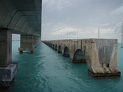 |
Key West Key West, Florida Key West is a city in Monroe County, Florida, United States. The city encompasses the island of Key West, the part of Stock Island north of U.S. 1 , Sigsbee Park , Fleming Key , and Sunset Key... |
Key Largo Key Largo, Florida Key Largo is a census-designated place in Monroe County, Florida, United States, located on the island of Key Largo in the upper Florida Keys. The population was 11,886 at the 2000 census. The name comes from the Spanish Cayo Largo, or "long key"... |
U.S. 1 U.S. Route 1 in Florida U.S. Route 1 in Florida runs along the state's east coast from Key West to its crossing of the St. Marys River into Georgia north of Boulogne, and south of Folkston. US 1 was designated through Florida when the U.S. Highway System was established in 1926.US 1 runs in the state of Florida, and... |
All-American Road |
| Tamiami Trail Scenic Highway | 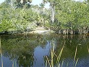 |
Sarasota Sarasota County, Florida Sarasota County is a county located in the U.S. state of Florida. The U.S. Census Bureau 2008 estimate for the county was 372,057. Its county seat is Sarasota, Florida.... /Charlotte Charlotte County, Florida Charlotte County is a county located in the U.S. state of Florida. As of 2000, the population was 141,627. In 2005, the population of the MSA was 154,030.The U.S. Census Bureau 2007 estimate for the county was 152,814... county line |
Hillsborough Hillsborough County, Florida As of the census of 2000, there were 998,948 people, 391,357 households, and 255,164 families residing in the county. The population density was 951 people per square mile . There were 425,962 housing units at an average density of 405 per square mile... /Manatee Manatee County, Florida Manatee County is a county in the state of Florida. According to the 2010 census by the U.S. Census Bureau there are 322,833 people living in Manatee Country.Manatee County is part of the North Port-Bradenton-Sarasota Metropolitan Statistical Area... county line |
U.S. 41 | Traverses the Florida Everglades |
| Big Bend Scenic Byway | Tallahassee Tallahassee, Florida Tallahassee is the capital of the U.S. state of Florida. It is the county seat and only incorporated municipality in Leon County, and is the 128th largest city in the United States. Tallahassee became the capital of Florida, then the Florida Territory, in 1824. In 2010, the population recorded by... |
Apalachicola Apalachicola, Florida Apalachicola is a city in Franklin County, Florida, on US 98 about southwest of Tallahassee. The population was 2,334 at the 2000 census. The 2005 census estimated the city's population at 2,340... |
U.S. 98 U.S. Route 98 in Florida U.S. Route 98 is an east-west United States highway that runs from western Mississippi to southern Florida. It was established in 1933 as a route between Pensacola, Florida and Apalachicola, Florida, and has since been extended eastward across the Florida Peninsula and westward into Mississippi... /S.R. 300/C.R. 59/S.R. 65/S.R. 267/C.R. 375 |
220 miles that travel through Leon County, Wakulla County, and Franklin County |
State designated scenic byways
| Name | Image | From | To | Highways | Notes |
|---|---|---|---|---|---|
| Bradenton Beach Scenic Highway | SR 789 Florida State Road 789 A 19-mile-long road along the Florida’s Gulf Coast, State Road 789 spans Bird Key, St. Armands Key, and Lido Key, in Sarasota; Longboat Key ; and Anna Maria Island... |
||||
| Broward County A1A Scenic Highway | |||||
| Courtney Campbell Scenic Highway |  |
SR 60 | |||
| Florida Black Bear Scenic Byway | SR 40/SR 19 Florida State Road 19 State Road 19 is a Florida State Road in Putnam, Marion, and Lake counties. It runs from Groveland to Palatka. It provides access to areas in Ocala National Forest, like Pittman.-Groveland to Tavares:... |
||||
| Florida Keys Scenic Highway | U.S. 1 U.S. Route 1 in Florida U.S. Route 1 in Florida runs along the state's east coast from Key West to its crossing of the St. Marys River into Georgia north of Boulogne, and south of Folkston. US 1 was designated through Florida when the U.S. Highway System was established in 1926.US 1 runs in the state of Florida, and... |
||||
| Green Mountain Scenic Byway | Lake CR 455/Old Lake CR 50/SR 438 Florida State Road 438 State Road 438 is a state highway in Orange and Lake counties. It is one of the 3 roads that goes through Killarney, the other 2 are SR 50 and Florida's Turnpike. In Oakland, it is the 2nd closest to Lake Apopka than any other Florida State Road, after SR 91.... |
||||
| Heritage Crossroads: Miles of History Heritage Highway | |||||
| Indian River Lagoon-Treasure Coast Scenic Highway | SR A1A Florida State Road A1A State Road A1A is a Florida State Road that runs mostly along the Atlantic Ocean, with sections from Key West at the southern tip of Florida, to Callahan, just south of Georgia. It is the main road through most oceanfront towns. SR A1A is designated the A1A Scenic and Historic Coastal Highway, a... /St. Lucie CR 707 |
||||
| J.C. Penney Memorial Scenic Highway | SR 16 | ||||
| Lemon Bay/Myakka Trail | |||||
| Old Florida Heritage Highway | U.S. 441 U.S. Route 441 in Florida U.S. Route 441 in Florida is a north–south United States Highway. It runs from Miami in South Florida northwest to the Georgia border north of the Lake City area.... |
||||
| Ormond Scenic Loop and Trail Ormond Scenic Loop and Trail The Ormond Scenic Loop and Trail is a series of scenic state and county highways in Volusia County, Florida.CR 2002 is the northern leg of the trail. CR 4011 is the western leg, with a spur onto Pine Tree Drive. SR 40 is the southern leg of the trail... |
-0947.jpg) |
||||
| Palma Sola Scenic Highway | SR 64 Florida State Road 64 State Road 64 extends from State Road 789 approximately two blocks from the Gulf of Mexico in Holmes Beach in Manatee County to US 27/US 98 in Avon Park in Highlands County. State Road 64 travels from west to east through the counties of Manatee, Hardee and Highlands. It is a mostly rural 2-lane... |
||||
| Pensacola Scenic Bluffs Highway | |||||
| River of Lakes Heritage Corridor Scenic Highway | US 17 U.S. Route 17 in Florida U.S. Route 17 in Florida is a north–south United States Highway. It runs from the Punta Gorda, Florida Metropolitan Statistical Area northeast to the Greater Jacksonville Metropolitan Area.... , CR 3, and SR 11 |
||||
| Scenic Highway 30A | Sandestin Sandestin, Florida Sandestin Golf and Beach Resort is a destination resort in Miramar Beach, Florida, United States, on Northwest Florida’s Gulf Coast. The resort is located between the Gulf of Mexico and the Choctawhatchee Bay, in Walton County... |
Inlet Beach Inlet Beach, Florida Inlet Beach is located in south Walton County, Florida. Inlet Beach is the most eastern South Walton County beach and is named after Phillips Inlet at the border of South Walton and Bay counties.... |
SR 30A | ||
| Suncoast Scenic Parkway | The Cheval Cheval, Florida Cheval is an unincorporated census-designated place in Hillsborough County, Florida, United States. The population was 10,702 at the 2010 census.-Geography:Cheval is located at .... |
Northern Hernando County | Toll SR 589 | ||
| The Ridge Scenic Highway | SR 17 Florida State Road 17 State Road 17 , also formerly known as Alternate U.S. 27, is a north–south state road in the U.S. state of Florida. It is split into two sections... |
||||
| William Bartram Scenic & Historic Trail | Old Bull Bay Bridge | St. Johns CR 210 | SR 13 | ||