

Effect of Hurricane Katrina on Mississippi
Encyclopedia

Hurricane Katrina's winds and storm surge reached the Mississippi
Mississippi
Mississippi is a U.S. state located in the Southern United States. Jackson is the state capital and largest city. The name of the state derives from the Mississippi River, which flows along its western boundary, whose name comes from the Ojibwe word misi-ziibi...
coastline on the afternoon of August 28, 2005,
beginning a two-day path of destruction through central Mississippi; by 10 a.m. CDT on August 29, 2005, the eye of Katrina began travelling up the entire state, only slowing from hurricane-force winds at Meridian
Meridian, Mississippi
Meridian is the county seat of Lauderdale County, Mississippi. It is the sixth largest city in the state and the principal city of the Meridian, Mississippi Micropolitan Statistical Area...
near 7 p.m. and entering Tennessee
Tennessee
Tennessee is a U.S. state located in the Southeastern United States. It has a population of 6,346,105, making it the nation's 17th-largest state by population, and covers , making it the 36th-largest by total land area...
as a tropical storm.
Many coastal towns of Mississippi (and Louisiana) had already been obliterated, in a single night.
Hurricane-force winds reached coastal Mississippi by 2 a.m. and lasted over 17 hours, spawning 11 tornado
Tornado
A tornado is a violent, dangerous, rotating column of air that is in contact with both the surface of the earth and a cumulonimbus cloud or, in rare cases, the base of a cumulus cloud. They are often referred to as a twister or a cyclone, although the word cyclone is used in meteorology in a wider...
es (51 in other states) and a 28-foot (9 m) storm surge flooding 6–12 miles (10–19 km) inland. Many, unable to evacuate,
survived by climbing to attics or rooftops, or swimming to higher buildings and trees. The worst property damage from Katrina occurred in coastal Mississippi, where all towns flooded over 90% in hours, and waves destroyed many historic buildings, with others gutted to the 3rd story. Afterward, over 235 people died in Mississippi, and all counties in Mississippi were declared disaster areas, 49 for full federal assistance.
Regulations were changed later for emergency centers and casinos. The emergency command centers were moved higher because all 3 coastal centers flooded at 30 ft (9 m) above sea level. Casinos were allowed on land rather than limited to floating casino barges as in 2005.
More than one million people in Mississippi were affected, and almost 6 months later, the extent of the devastation in Mississippi was still described as "staggering" in USA Today
USA Today
USA Today is a national American daily newspaper published by the Gannett Company. It was founded by Al Neuharth. The newspaper vies with The Wall Street Journal for the position of having the widest circulation of any newspaper in the United States, something it previously held since 2003...
on February 16, 2006:
"The Mississippi Gulf Coast has been devastated. The extent of the devastation in Mississippi is also staggering. Since Katrina hit, more than half a million people in Mississippi have applied for assistance from FEMA
Federal Emergency Management Agency
The Federal Emergency Management Agency is an agency of the United States Department of Homeland Security, initially created by Presidential Reorganization Plan No. 1 of 1978 and implemented by two Executive Orders...
. In a state of just 2.9 million residents, that means more than one in six Mississippi
Mississippi
Mississippi is a U.S. state located in the Southern United States. Jackson is the state capital and largest city. The name of the state derives from the Mississippi River, which flows along its western boundary, whose name comes from the Ojibwe word misi-ziibi...
ans have sought help. More than 97,000 people are still living in FEMA trailers and mobile homes. Another 5,000 to 6,000 are still waiting for FEMA trailers. Almost six months later, many neighborhoods are still piled high with storm debris" (reported February 2006).
Scattered damage
General: The effects of a hurricane can be scattered across a large area, because hurricanes are large, complex storms which spawn smaller thunderstorms, tornadoes, storm surges, and sea waves. Wind speeds east of the eyewall can be 40-50 mph (64–80 km/h) higher than winds west of the eye. Wind gusts can be scattered, just as boats or debris can ram one house but not another. One building can seem untouched, while others nearby are flattened; also trees can be partially weakened: tree limbs can fall months later, crashing onto a roof, automobile, fence, etc.Specific: Because Hurricane Katrina became a massive storm,
over 450 miles (720 km) wide, not only the eyewall-path, and 28-foot (9 m) storm surge, but also the outer bands of the hurricane arms caused scattered damage hundreds of miles away from the center. Eleven (11) spawned tornadoes were recorded in Mississippi (51 elsewhere).
It is possible that scattered damage to northern Mississippi occurred, by spin-off storms, around the time Katrina made landfall in eastern Greater New Orleans (Louisiana's "boot toe") and then, again, near Bay St. Louis, Mississippi
Bay St. Louis, Mississippi
Bay Saint Louis is a city located in Hancock County, Mississippi. It is part of the Gulfport–Biloxi, Mississippi Metropolitan Statistical Area. As of the 2000 census, the city had a total population of 8,209. It is the county seat of Hancock County...
, heading north-northeast into central Mississippi, at 10 a.m. on August 29. Note that "landfall" occurred over towns submerged under 20 feet (6 m
M
M is the thirteenth letter of the basic modern Latin alphabet.-History:The letter M is derived from the Phoenician Mem, via the Greek Mu . Semitic Mem probably originally pictured water...
) of water. As buildings collapsed, water-tight appliances floated, sending refrigerators and dishwashers to ram other buildings and block streets. Millions of homes and buildings were affected, along with ships, boats, and more than 40 offshore oil rigs.
Impact synopsis

Mississippi
Mississippi is a U.S. state located in the Southern United States. Jackson is the state capital and largest city. The name of the state derives from the Mississippi River, which flows along its western boundary, whose name comes from the Ojibwe word misi-ziibi...
suffered near total devastation
from Hurricane Katrina on August 28–29, with hurricane winds, 28-foot (9 m) storm surge, and 55-foot (17 m) sea waves
pushing casino barges, boats and debris into towns, and leaving 236 people dead, 67 missing, and an estimated US$125 billion in damages.
Since Katrina made landfall below central Mississippi, 30 miles (48 km) east of New Orleans
New Orleans, Louisiana
New Orleans is a major United States port and the largest city and metropolitan area in the state of Louisiana. The New Orleans metropolitan area has a population of 1,235,650 as of 2009, the 46th largest in the USA. The New Orleans – Metairie – Bogalusa combined statistical area has a population...
at 6:10 a.m., the storm's powerful, right, front quadrant covered coastal Mississippi
Mississippi
Mississippi is a U.S. state located in the Southern United States. Jackson is the state capital and largest city. The name of the state derives from the Mississippi River, which flows along its western boundary, whose name comes from the Ojibwe word misi-ziibi...
and southern Alabama
Alabama
Alabama is a state located in the southeastern region of the United States. It is bordered by Tennessee to the north, Georgia to the east, Florida and the Gulf of Mexico to the south, and Mississippi to the west. Alabama ranks 30th in total land area and ranks second in the size of its inland...
, increasing wind and flood damage. After making initial landfall in Louisiana
Louisiana
Louisiana is a state located in the southern region of the United States of America. Its capital is Baton Rouge and largest city is New Orleans. Louisiana is the only state in the U.S. with political subdivisions termed parishes, which are local governments equivalent to counties...
, four hours later Katrina made another landfall north at the state line (near the mouth of the Pearl River
Pearl River (Mississippi-Louisiana)
The Pearl River is a river in the U.S. states of Mississippi and Louisiana. It forms in Neshoba County, Mississippi from the confluence of Nanih Waiya and Tallahaga creeks. It is long. The Yockanookany and Strong rivers are tributaries. Northeast of Jackson, the Ross Barnett Reservoir is formed by...
) and passed over submerged towns around Bay St. Louis
Bay St. Louis, Mississippi
Bay Saint Louis is a city located in Hancock County, Mississippi. It is part of the Gulfport–Biloxi, Mississippi Metropolitan Statistical Area. As of the 2000 census, the city had a total population of 8,209. It is the county seat of Hancock County...
as a Category 3
Saffir-Simpson Hurricane Scale
The Saffir–Simpson Hurricane Scale , or the Saffir–Simpson Hurricane Wind Scale , classifies hurricanes — Western Hemisphere tropical cyclones that exceed the intensities of tropical depressions and tropical storms — into five categories distinguished by the intensities of their sustained winds...
hurricane with winds over 120 mph (192 km/h) and 28-foot (9 m) surge. Battered by wind, rain and storm surges, some beachfront neighborhoods were leveled entirely, with flooding 6–12 miles (10–19 km) inland, crossing Interstate-10
Interstate 10
Interstate 10 is the fourth-longest Interstate Highway in the United States, after I-90, I-80, and I-40. It is the southernmost east–west, coast-to-coast Interstate Highway, although I-4 and I-8 are further south. It stretches from the Pacific Ocean at State Route 1 in Santa Monica,...
(I-10) in some places.
Winds reached hurricane-force in Hancock
Hancock County, Mississippi
-Demographics:As of the census of 2000, there were 42,967 people, 16,897 households, and 11,827 families residing in the county. The population density was 90 people per square mile . There were 21,072 housing units at an average density of 44 per square mile...
and Harrison County
Harrison County, Mississippi
-National protected areas:* De Soto National Forest * Gulf Islands National Seashore - Demographics :As of the census of 2000, there were 189,601 people, 71,538 households, and 48,574 families residing in the county. The population density was 326 people per square mile . There were 79,636 housing...
by 2 a.m.,
and winds intensified. As Katrina passed 30 miles (48 km) east of central New Orleans, with 57 mph (91 km/h) winds, by 10 a.m., landfall in Mississippi increased hurricane-force winds in an area of 600,000 Mississippi residents, covering several counties (see Figure KW10: Katrina Wind Speed map): Hancock
Hancock County, Mississippi
-Demographics:As of the census of 2000, there were 42,967 people, 16,897 households, and 11,827 families residing in the county. The population density was 90 people per square mile . There were 21,072 housing units at an average density of 44 per square mile...
, Harrison
Harrison County, Mississippi
-National protected areas:* De Soto National Forest * Gulf Islands National Seashore - Demographics :As of the census of 2000, there were 189,601 people, 71,538 households, and 48,574 families residing in the county. The population density was 326 people per square mile . There were 79,636 housing...
, Jackson County
Jackson County, Mississippi
There were 47,676 households out of which 37.00% had children under the age of 18 living with them, 55.70% were married couples living together, 14.50% had a female householder with no husband present, and 25.10% were non-families. 20.80% of all households were made up of individuals and 7.10% had...
, Pearl River County
Pearl River County, Mississippi
-National protected areas:*Bogue Chitto National Wildlife Refuge *De Soto National Forest -Demographics:The census estimates of 2006 place the county population over 57,000 and place it among the 10 fastest growing counties in the U.S. As of the census of 2000, there were 48,621 people, 18,078...
, Stone
Stone County, Mississippi
As of the census of 2000, there were 13,622 people, 4,747 households, and 3,626 families residing in the county. The population density was 31 people per square mile . There were 5,343 housing units at an average density of 12 per square mile...
, Walthall
Walthall County, Mississippi
-Demographics:As of the census of 2000, there were 15,156 people, 5,571 households, and 4,111 families residing in the county. The population density was 38 people per square mile . There were 6,418 housing units at an average density of 16 per square mile...
, Marion
Marion County, Mississippi
-Demographics:As of the census of 2000, there were 25,595 people, 9,336 households, and 6,880 families residing in the county. The population density was 47 people per square mile . There were 10,395 housing units at an average density of 19 per square mile...
, Lamar County
Lamar County, Mississippi
-Demographics:As of the census of 2000, there were 39,070 people, 14,396 households, and 10,725 families residing in the county. The population density was 79 people per square mile . There were 15,433 housing units at an average density of 31 per square mile...
, Forrest County
Forrest County, Mississippi
The median income for a household in the county was $27,420, and the median income for a family was $35,791. Males had a median income of $28,742 versus $20,500 for females. The per capita income for the county was $15,160...
, and Perry County
Perry County, Mississippi
-Demographics:As of the census of 2000, there were 12,138 people, 4,420 households, and 3,332 families residing in the county. The population density was 19 people per square mile . There were 5,107 housing units at an average density of 8 per square mile...
(see Map of Counties). Other counties to see a strong hurricane force impact of Katrina were Covington County
Covington County, Mississippi
-2010 Census:As of the most recent census, 2010, the population of Covington County is 19,568, only a slight increase from 2000. Racially, the population was distributed with 62.7% being White, 34.7% Black/African American, 1.9% Hispanic/Latino, 0.2% Asian, 0.1% American Indian/Alaskan Native, and...
, Jefferson Davis County
Jefferson Davis County, Mississippi
-Demographics:As of the census of 2000, there were 13,962 people, 5,177 households, and 3,768 families residing in the county. The population density was 34 people per square mile . There were 5,891 housing units at an average density of 14 per square mile...
, Simpson County
Simpson County, Mississippi
-Demographics:As of the census of 2000, there were 27,639 people, 10,076 households, and 7,385 families residing in the county. The population density was 47 people per square mile . There were 11,307 housing units at an average density of 19 per square mile...
, Smith County
Smith County, Mississippi
-Demographics:As of the census of 2000, there were 16,182 people, 6,046 households, and 4,558 families residing in the county. The population density was 25 people per square mile . There were 7,005 housing units at an average density of 11 per square mile...
, Hinds County
Hinds County, Mississippi
As of the census of 2000, there were 250,800 people, 91,030 households, and 62,355 families residing in the county. The population density was 288 people per square mile . There were 100,287 housing units at an average density of 115 per square mile...
, Rankin County
Rankin County, Mississippi
-Demographics:As of the census of 2000, there were 115,327 people, 42,089 households, and 31,145 families residing in the county. The population density was 149 people per square mile . There were 45,070 housing units at an average density of 58 per square mile...
, and Scott County
Scott County, Mississippi
-Demographics:As of the census of 2000, there were 28,423 people, 10,183 households, and 7,535 families residing in the county. The population density was 47 people per square mile . There were 11,116 housing units at an average density of 18 per square mile...
. Katrina maintained a high wind capacity of 80–85 mph in cities like Mendenhall, Magee, Jackson, Brandon, and Forest in Mississippi. Those cities contained much tree damage, roof and patio damage, power line damage, and much thrown debris. In Jackson
Jackson, Mississippi
Jackson is the capital and the most populous city of the US state of Mississippi. It is one of two county seats of Hinds County ,. The population of the city declined from 184,256 at the 2000 census to 173,514 at the 2010 census...
, streets were cleared off due to the intense strong winds and rains that carried throughout the entire day. During this 10 a.m. timeframe, hurricane-force winds continued over the barrier islands and Louisiana peninsula nearby; however, for the remainder of Louisiana, the winds were subsiding into gale-force winds after 10 a.m. when Katrina was becoming primarily a Mississippi hurricane.

MSNBC
MSNBC is a cable news channel based in the United States available in the US, Germany , South Africa, the Middle East and Canada...
, a 28-foot (9 m) storm surge came ashore wiping out 90% of the buildings along the Biloxi
Biloxi, Mississippi
Biloxi is a city in Harrison County, Mississippi, in the United States. The 2010 census recorded the population as 44,054. Along with Gulfport, Biloxi is a county seat of Harrison County....
-Gulfport
Gulfport, Mississippi
Gulfport is the second largest city in Mississippi after the state capital Jackson. It is the larger of the two principal cities of the Gulfport-Biloxi, Mississippi Metropolitan Statistical Area, which is included in the Gulfport-Biloxi-Pascagoula, Mississippi Combined Statistical Area. As of the...
coastline. A number of streets and bridges were washed away, including the bridge sections of U.S. Highway 90. In particular, the roadway portion of the U.S. Highway 90 bridge between Bay St. Louis
Bay St. Louis, Mississippi
Bay Saint Louis is a city located in Hancock County, Mississippi. It is part of the Gulfport–Biloxi, Mississippi Metropolitan Statistical Area. As of the 2000 census, the city had a total population of 8,209. It is the county seat of Hancock County...
and Pass Christian
Pass Christian, Mississippi
Pass Christian , nicknamed The Pass, is a city in Harrison County, Mississippi, United States, along the Gulf of Mexico. It is part of the Gulfport–Biloxi, Mississippi Metropolitan Statistical Area...
was completely destroyed by the storm; only the support structure was left.
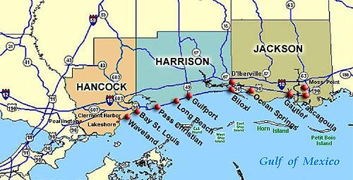
The three counties most affected by the storm were Hancock County
Hancock County, Mississippi
-Demographics:As of the census of 2000, there were 42,967 people, 16,897 households, and 11,827 families residing in the county. The population density was 90 people per square mile . There were 21,072 housing units at an average density of 44 per square mile...
, Harrison County
Harrison County, Mississippi
-National protected areas:* De Soto National Forest * Gulf Islands National Seashore - Demographics :As of the census of 2000, there were 189,601 people, 71,538 households, and 48,574 families residing in the county. The population density was 326 people per square mile . There were 79,636 housing...
, and Jackson County
Jackson County, Mississippi
There were 47,676 households out of which 37.00% had children under the age of 18 living with them, 55.70% were married couples living together, 14.50% had a female householder with no husband present, and 25.10% were non-families. 20.80% of all households were made up of individuals and 7.10% had...
, although almost all counties had damage, and 47 counties were declared full disaster areas. Mississippi Emergency Management Agency
(MEMA) officials also recorded deaths in Hinds
Hinds County, Mississippi
As of the census of 2000, there were 250,800 people, 91,030 households, and 62,355 families residing in the county. The population density was 288 people per square mile . There were 100,287 housing units at an average density of 115 per square mile...
, Warren
Warren County, Mississippi
-National protected areas:* Theodore Roosevelt National Wildlife Refuge * Vicksburg National Military Park -Demographics:As of the census of 2000, there were 49,644 people, 18,756 households, and 13,222 families residing in the county. The population density was 85 people per square mile...
, and Leake
Leake County, Mississippi
-Demographics:As of the census of 2000, there were 20,940 people, 7,611 households, and 5,563 families residing in the county. The population density was 36 people per square mile . There were 8,585 housing units at an average density of 15 per square mile...
counties. About 800,000 people through the state experienced power outages, which is almost a third of the population.
The three coastal counties of Mississippi, populated by about 400,000 people (almost the population of central New Orleans), had been mostly evacuated before Katrina flooded the 100 miles (160.9 km) region. Katrina's storm surge was the most extensive, as well as the highest, in the documented history of the United States; large portions of Hancock County, Harrison County, and Jackson County were inundated by the storm surge, affecting most of the populated areas.
Surge covered almost the entire lower half of Hancock County, destroying the coastal communities of Clermont Harbor
Clermont Harbor, Mississippi
Clermont Harbor is an unincorporated village on the western end of Hancock County on the Gulf Coast of the U.S. state of Mississippi. It is part of the Gulfport–Biloxi, Mississippi Metropolitan Statistical Area....
and Waveland
Waveland, Mississippi
Waveland is a city located in Hancock County, Mississippi, on the Gulf of Mexico. It is part of the Gulfport–Biloxi, Mississippi Metropolitan Statistical Area. The City of Waveland was incorporated in 1972. As of the 2000 census, the city had a total population of 6,674...
, and much of Bay St. Louis
Bay St. Louis, Mississippi
Bay Saint Louis is a city located in Hancock County, Mississippi. It is part of the Gulfport–Biloxi, Mississippi Metropolitan Statistical Area. As of the 2000 census, the city had a total population of 8,209. It is the county seat of Hancock County...
, and flowed up the Jourdan River, flooding Kiln
Kiln, Mississippi
Kiln is a census-designated place in Hancock County, Mississippi, United States. It is part of the Gulfport–Biloxi, Mississippi Metropolitan Statistical Area...
. In Harrison County, Pass Christian was completely inundated, along with a narrow strip of land to the east along the coast, which includes the cities of Long Beach
Long Beach, Mississippi
Long Beach is a city located in Harrison County, Mississippi, USA. It is part of the Gulfport–Biloxi, Mississippi Metropolitan Statistical Area...
and Gulfport
Gulfport, Mississippi
Gulfport is the second largest city in Mississippi after the state capital Jackson. It is the larger of the two principal cities of the Gulfport-Biloxi, Mississippi Metropolitan Statistical Area, which is included in the Gulfport-Biloxi-Pascagoula, Mississippi Combined Statistical Area. As of the...
; the flooding was more extensive in communities such as D'Iberville, which borders Back Bay. Biloxi, on a peninsula between the Back Bay and the coast, was particularly hard hit, especially the low-lying Point Cadet area.
In Jackson County, storm surge flowed up the wide river estuary
Estuary
An estuary is a partly enclosed coastal body of water with one or more rivers or streams flowing into it, and with a free connection to the open sea....
, with the combined surge and freshwater floods cutting the county in half. Over 90% of Pascagoula
Pascagoula, Mississippi
Pascagoula is a city in Jackson County, Mississippi, United States. It is the principal city of the Pascagoula, Mississippi Metropolitan Statistical Area, as a part of the Gulfport–Biloxi–Pascagoula, Mississippi Combined Statistical Area. The population was 26,200 at the 2000 census...
, the easternmost coastal city in Mississippi, was flooded from surge. Other Jackson County communities such as Porteaux Bay and Gulf Shores were destroyed, and St. Martin
St. Martin, Mississippi
St. Martin is a census-designated place in Jackson County, Mississippi, United States. It is part of the Pascagoula, Mississippi Metropolitan Statistical Area. The population was 6,676 at the 2000 census.St...
was hard hit, along with Ocean Springs
Ocean Springs, Mississippi
Ocean Springs is a city in Jackson County, Mississippi, United States, about east of Biloxi. It is part of the Pascagoula, Mississippi Metropolitan Statistical Area. The population was 17,225 at the 2000 census...
, Moss Point
Moss Point, Mississippi
Moss Point is a city, north of Pascagoula, in Jackson County, Mississippi, United States. The population was 17,653 at the 2000 census.On August 29, 2005, Moss Point was hit by the strong east side of Hurricane Katrina, and much of Moss Point was flooded or destroyed .-Geography:Moss Point is...
, Gautier
Gautier, Mississippi
Gautier is a city in Jackson County, Mississippi, United States, along the Gulf of Mexico west of Pascagoula. It is part of the Pascagoula, Mississippi Metropolitan Statistical Area. The population was 11,681 at the 2000 census. In 2002, Gautier annexed land nearly doubling its population to...
, and Escatawpa.
Two destroyer
Destroyer
In naval terminology, a destroyer is a fast and maneuverable yet long-endurance warship intended to escort larger vessels in a fleet, convoy or battle group and defend them against smaller, powerful, short-range attackers. Destroyers, originally called torpedo-boat destroyers in 1892, evolved from...
s that were under construction at Litton-Ingalls Shipbuilding in Pascagoula
Pascagoula, Mississippi
Pascagoula is a city in Jackson County, Mississippi, United States. It is the principal city of the Pascagoula, Mississippi Metropolitan Statistical Area, as a part of the Gulfport–Biloxi–Pascagoula, Mississippi Combined Statistical Area. The population was 26,200 at the 2000 census...
were damaged, as well as the Amphibious assault ship
Amphibious assault ship
An amphibious assault ship is a type of amphibious warfare ship employed to land and support ground forces on enemy territory by an amphibious assault...
USS Makin Island
USS Makin Island (LHD-8)
USS Makin Island , a Wasp-class amphibious assault ship, is the second ship of the United States Navy to be named for Makin Island, target of the Marine Raiders' Makin Island raid early on in the United States' involvement in World War II....
.
Surveying the damage the day after Katrina's passing, Mississippi governor Haley Barbour
Haley Barbour
Haley Reeves Barbour is an American Republican politician currently serving as the 63rd Governor of Mississippi. He gained a national spotlight in August 2005 after Mississippi was hit by Hurricane Katrina. Barbour won re-election as Governor in 2007...
called the scene indescribable, saying "I can only imagine that this is what Hiroshima
Hiroshima
is the capital of Hiroshima Prefecture, and the largest city in the Chūgoku region of western Honshu, the largest island of Japan. It became best known as the first city in history to be destroyed by a nuclear weapon when the United States Army Air Forces dropped an atomic bomb on it at 8:15 A.M...
looked like 60 years ago."
The mayor of Biloxi, A.J. Holloway, told the Biloxi Sun Herald, "This is our tsunami."
Relief and rebuilding efforts initially focused on restoring power and clearing communities of debris up to eight feet (2.4 m) in depth.
Many historic buildings were destroyed in Mississippi, including the cottages and second-story porches around the Beauvoir
Beauvoir
Beauvoir can refer to any of the following:Buildings*Beauvoir , post-American Civil War home of Confederate States of America President Jefferson DavisPeople*Jean Beauvoir, American musician....
mansion, home of Jefferson Davis
Jefferson Davis
Jefferson Finis Davis , also known as Jeff Davis, was an American statesman and leader of the Confederacy during the American Civil War, serving as President for its entire history. He was born in Kentucky to Samuel and Jane Davis...
. Hundreds of irreplaceable Civil War-era artifacts from the Jefferson Davis home and museum were either lost or destroyed.
The lower three floors of many high-rise casinos and hotels were gutted. (See details below).
Along with countless others affected by the hurricane, US Senator Trent Lott
Trent Lott
Chester Trent Lott, Sr. , is a former United States Senator from Mississippi and has served in numerous leadership positions in the House of Representatives and the Senate....
lost his Pascagoula home, and the boyhood home of Green Bay Packers
Green Bay Packers
The Green Bay Packers are an American football team based in Green Bay, Wisconsin. They are members of the North Division of the National Football Conference in the National Football League . The Packers are the current NFL champions...
quarterback Brett Favre
Brett Favre
Brett Lorenzo Favre is a former American football quarterback who spent the majority of his career with the Green Bay Packers of the National Football League . He was a 20-year veteran of the NFL, having played quarterback for the Atlanta Falcons , Green Bay Packers , New York Jets and Minnesota...
was also totally destroyed.
Psychological Impact
Both the Mississippi residents who survived the hurricanes as well as the disaster relief workers who supported them are at high risk of developing Post-Traumatic Stress Disorder, or PTSD, a mental health disorder that can develop after exposure to an extreme situation such as warfare, a natural disaster or abuse.Path of Hurricane Katrina
Although Hurricane KatrinaHurricane Katrina
Hurricane Katrina of the 2005 Atlantic hurricane season was a powerful Atlantic hurricane. It is the costliest natural disaster, as well as one of the five deadliest hurricanes, in the history of the United States. Among recorded Atlantic hurricanes, it was the sixth strongest overall...
later travelled mainly through Mississippi
Mississippi
Mississippi is a U.S. state located in the Southern United States. Jackson is the state capital and largest city. The name of the state derives from the Mississippi River, which flows along its western boundary, whose name comes from the Ojibwe word misi-ziibi...
,
it began as a Category 1 hurricane on August 25, crossing the southern tip
of Florida (raining 14 inches (355.6 mm) [36 cm]
"Tropical Cyclone Report, Hurricane Katrina,"
(post-analysis) National Hurricane Center,
revised August 10, 2006.)
into the Gulf
Gulf of Mexico
The Gulf of Mexico is a partially landlocked ocean basin largely surrounded by the North American continent and the island of Cuba. It is bounded on the northeast, north and northwest by the Gulf Coast of the United States, on the southwest and south by Mexico, and on the southeast by Cuba. In...
, where it weakened, then strengthened
into a massive Category 5 with 175 mph (280 km/h) sustained winds. Slowly turning north along the eastern coast of Louisiana, at 4 a.m. August 29, sustained winds were 132 mph (211 km/h), 90 miles (114 km) SSE
SSE
-Computing:*Server-sent events, a technology to push content to web clients*Simple Sharing Extensions, a specification that extends RSS from unidirectional to bidirectional information flows*SPARQL Syntax Expressions*Microsoft SQL Server Express Edition...
of New Orleans.
As Katrina came ashore near Buras, LA at 6:10 CDT, with
reported 125 mi/h winds (Category 3), it passed 40 miles (64.4 km) east of New Orleans and headed to the Mississippi state line (mouth of Pearl River
Pearl River (Mississippi-Louisiana)
The Pearl River is a river in the U.S. states of Mississippi and Louisiana. It forms in Neshoba County, Mississippi from the confluence of Nanih Waiya and Tallahaga creeks. It is long. The Yockanookany and Strong rivers are tributaries. Northeast of Jackson, the Ross Barnett Reservoir is formed by...
, 10 a.m. CDT),
with hurricane-force winds travelling up central Mississippi until weakening at Meridian
Meridian, Mississippi
Meridian is the county seat of Lauderdale County, Mississippi. It is the sixth largest city in the state and the principal city of the Meridian, Mississippi Micropolitan Statistical Area...
,
and entering Tennessee
Tennessee
Tennessee is a U.S. state located in the Southeastern United States. It has a population of 6,346,105, making it the nation's 17th-largest state by population, and covers , making it the 36th-largest by total land area...
as a tropical storm. Despite the hurricane force centered on Mississippi, neighboring areas were also affected: when New Orleans began slowly flooding with high east/north winds, a 28-foot (9 m) storm surge eastward from Bay St. Louis
Bay St. Louis, Mississippi
Bay Saint Louis is a city located in Hancock County, Mississippi. It is part of the Gulfport–Biloxi, Mississippi Metropolitan Statistical Area. As of the 2000 census, the city had a total population of 8,209. It is the county seat of Hancock County...
devastated coastal areas with 30–55 foot (17 m) sea waves, flooding 12 miles (19 km) inland. The waves pushed barges, oil rigs, ships, and debris into submerged towns to flatten many coastal buildings across to Pascagoula
Pascagoula, Mississippi
Pascagoula is a city in Jackson County, Mississippi, United States. It is the principal city of the Pascagoula, Mississippi Metropolitan Statistical Area, as a part of the Gulfport–Biloxi–Pascagoula, Mississippi Combined Statistical Area. The population was 26,200 at the 2000 census...
with 20-foot (6 m) surge, and into Alabama
Alabama
Alabama is a state located in the southeastern region of the United States. It is bordered by Tennessee to the north, Georgia to the east, Florida and the Gulf of Mexico to the south, and Mississippi to the west. Alabama ranks 30th in total land area and ranks second in the size of its inland...
with 15-foot (5 m) surge and 24-foot (7 m) waves battering beach houses inside Mobile Bay
Mobile Bay
Mobile Bay is an inlet of the Gulf of Mexico, lying within the state of Alabama in the United States. Its mouth is formed by the Fort Morgan Peninsula on the eastern side and Dauphin Island, a barrier island on the western side. The Mobile River and Tensaw River empty into the northern end of the...
and tilting the battleship USS Alabama
USS Alabama (BB-60)
USS Alabama , a South Dakota-class battleship, was the sixth completed ship of the United States Navy named for the U.S. state of Alabama, however she was only the third commissioned ship with that name. Alabama was commissioned in 1942 and served in World War II in the Atlantic and Pacific...
. (See extensive details below).
Mississippi evacuation
By 4:30 a.m. CDT, on August 29, 2005, just hours before Hurricane Katrina landfall, many shelters in Mississippi were full to capacity, including many Red Cross shelters, the JacksonJackson, Mississippi
Jackson is the capital and the most populous city of the US state of Mississippi. It is one of two county seats of Hinds County ,. The population of the city declined from 184,256 at the 2000 census to 173,514 at the 2010 census...
Coliseum (which allowed pets), and five special-needs shelters. The shelters had filled within 24 hours of opening.
Days earlier, on August 25, when Hurricane Katrina crossed the southern tip of Florida
Florida
Florida is a state in the southeastern United States, located on the nation's Atlantic and Gulf coasts. It is bordered to the west by the Gulf of Mexico, to the north by Alabama and Georgia and to the east by the Atlantic Ocean. With a population of 18,801,310 as measured by the 2010 census, it...
, government offices in Mississippi had already discussed emergency evacuation plans for days. On August 26, the Mississippi National Guard
Mississippi National Guard
The Mississippi National Guard is Mississippi's component of the United States National Guard.The Constitution of the United States specifically charges the National Guard with dual federal and state missions. In fact, the National Guard is the only United States military force empowered to...
was activated, raising the level of concern, and on August 27, the state government activated its Emergency Operations Center, and local governments began issuing evacuation orders: the Mississippi Emergency Management Agency (MEMA) advised not opening shelters in coastal counties. However, on August 28, the Red Cross also opened shelters in coastal counties, and by 7:00 p.m., 11 counties and eleven cities issued evacuation orders, a number which increased to 41 counties and 61 cities before the following morning, when Katrina came ashore. Moreover, 57 emergency shelters were established on coastal communities, with 31 additional shelters available to open if needed....
Since the evacuation was not total, many people survived the 30-foot (9 m) storm tide by climbing into the second-floor attic, or knocking out walls and ceiling boards to climb onto the roof or nearby trees. Tree trunks remained standing, even near the beaches, where many houses were leveled. Other people had swum to taller buildings or trees.
Over 100 people were rescued from roof tops and trees in Mississippi.
Although the population of the three (3) coastal counties had been nearly 400,000, and the storm tide was 20–30 feet (9 m) with coastal winds 75-120 mph (120–192 km/h), fewer than 350 people died in Mississippi during Hurricane Katrina.
Federal buildings/projects
Because of federal intent to rebuild or recover projects of the US Federal Government, the damage assessment to federal buildings in Mississippi covers actual costs: the amount needed to resume operations at market costs. The following federal projects are described in terms of damage, along with the cost to resume operations:- $1.987 billion: as requested by President George W. BushGeorge W. BushGeorge Walker Bush is an American politician who served as the 43rd President of the United States, from 2001 to 2009. Before that, he was the 46th Governor of Texas, having served from 1995 to 2000....
, for Navy Shipbuilding and Conversion; these funds will assist Northrop GrummanNorthrop GrummanNorthrop Grumman Corporation is an American global aerospace and defense technology company formed by the 1994 purchase of Grumman by Northrop. The company was the fourth-largest defense contractor in the world as of 2010, and the largest builder of naval vessels. Northrop Grumman employs over...
to "replace destroyed or damaged equipment, prepare and recover naval vessels under contract; and provide for cost adjustments." Ships were damaged in PascagoulaPascagoula, MississippiPascagoula is a city in Jackson County, Mississippi, United States. It is the principal city of the Pascagoula, Mississippi Metropolitan Statistical Area, as a part of the Gulfport–Biloxi–Pascagoula, Mississippi Combined Statistical Area. The population was 26,200 at the 2000 census...
. - (unknown): as increased funding for USDAUnited States Department of AgricultureThe United States Department of Agriculture is the United States federal executive department responsible for developing and executing U.S. federal government policy on farming, agriculture, and food...
housing programs which provide subsidized loans and housing repair funding. - $75 million: in wildlife habitat restoration, for the Corps of Engineers to enhance estuarine habitats in Mississippi: following the Governor’s proposal regarding oyster reef and coastal marsh restoration. The Mississippi Department of Marine Resources will assist the Corps as these projects develop.
- $75 million: for the Corps of Engineers on various coastal projects: to accelerate completion of authorized projects along the Mississippi Gulf Coast.
- $1.1 billion: to repair vital federal facilities in Mississippi, including:
-
- $292.5 million for the repair and renovation of the VAUnited States Department of Veterans AffairsThe United States Department of Veterans Affairs is a government-run military veteran benefit system with Cabinet-level status. It is the United States government’s second largest department, after the United States Department of Defense...
hospital in Biloxi. - $45 million for the Armed Forces Retirement Home in Gulfport.
- $277.2 million for the United States NavyUnited States NavyThe United States Navy is the naval warfare service branch of the United States Armed Forces and one of the seven uniformed services of the United States. The U.S. Navy is the largest in the world; its battle fleet tonnage is greater than that of the next 13 largest navies combined. The U.S...
to help rebuild the SeabeeSeabeeSeabees are members of the United States Navy construction battalions. The word Seabee is a proper noun that comes from the initials of Construction Battalion, of the United States Navy...
base in Gulfport, and the Stennis Space Center. - $43.4 million to help rebuild Keesler Air Force BaseKeesler Air Force BaseKeesler Air Force Base is a United States Air Force base located in Biloxi, a city in Harrison County, Mississippi, United States. The base is named in honor of aviator 2d Lt Samuel Reeves Keesler, Jr., a Mississippi native killed in France in First World War.-Units:The base is home of...
. - $45 million for the Keesler Medical Center.
- $82.8 million for new Navy housing in the Gulfport/Stennis region.
- $324.8 million for housing at Keesler Air Force BaseKeesler Air Force BaseKeesler Air Force Base is a United States Air Force base located in Biloxi, a city in Harrison County, Mississippi, United States. The base is named in honor of aviator 2d Lt Samuel Reeves Keesler, Jr., a Mississippi native killed in France in First World War.-Units:The base is home of...
. - $48.9 million for Navy housing at the Naval Air Station MeridianNaval Air Station MeridianNaval Air Station Meridian or NAS Meridian is a military airport located 11 miles northeast of Meridian, Mississippi in Lauderdale County and Kemper County, and is one of the Navy's two jet strike pilot training bases .-History:On July 16, 1957, the first shovel of earth was thrown, marking the...
and at the Seabee base in Gulfport.
- $292.5 million for the repair and renovation of the VA
The cost amounts were decided for work continuing in 2006. Note that repairs include modern renovation, since it is not feasible to assess damage in terms of restoring federal buildings to the year they were built. However, the costs provide a condensed measure of the construction damage, without counting the millions of lost roof tiles, thousands of broken windows, etc.
Hancock County
Hancock County, Mississippi
-Demographics:As of the census of 2000, there were 42,967 people, 16,897 households, and 11,827 families residing in the county. The population density was 90 people per square mile . There were 21,072 housing units at an average density of 44 per square mile...
was the scene of the final landfall of the eye of Hurricane Katrina
Hurricane Katrina
Hurricane Katrina of the 2005 Atlantic hurricane season was a powerful Atlantic hurricane. It is the costliest natural disaster, as well as one of the five deadliest hurricanes, in the history of the United States. Among recorded Atlantic hurricanes, it was the sixth strongest overall...
, causing total devastation in Waveland
Waveland, Mississippi
Waveland is a city located in Hancock County, Mississippi, on the Gulf of Mexico. It is part of the Gulfport–Biloxi, Mississippi Metropolitan Statistical Area. The City of Waveland was incorporated in 1972. As of the 2000 census, the city had a total population of 6,674...
, Bay St. Louis
Bay St. Louis, Mississippi
Bay Saint Louis is a city located in Hancock County, Mississippi. It is part of the Gulfport–Biloxi, Mississippi Metropolitan Statistical Area. As of the 2000 census, the city had a total population of 8,209. It is the county seat of Hancock County...
, Pearlington
Pearlington, Mississippi
Pearlington is a census-designated place in Hancock County, Mississippi, United States, on U.S. Route 90, along the Pearl River, at the Louisiana stateline. It is part of the Gulfport–Biloxi, Mississippi Metropolitan Statistical Area. The population was 1,684 at the 2000 census. On August...
, and Clermont Harbor
Clermont Harbor, Mississippi
Clermont Harbor is an unincorporated village on the western end of Hancock County on the Gulf Coast of the U.S. state of Mississippi. It is part of the Gulfport–Biloxi, Mississippi Metropolitan Statistical Area....
, as well as southern Diamondhead
Diamondhead, Mississippi
-Demographics:As of the census of 2010, there were 8,425 people, 3,586 households, and 2,507 families residing in the CDP. The population density was 745.6 people per square mile . There were 4,308 housing units at an average density of 381.2/sq mi...
. The bridge between Bay St. Louis and Pass Christian
Pass Christian, Mississippi
Pass Christian , nicknamed The Pass, is a city in Harrison County, Mississippi, United States, along the Gulf of Mexico. It is part of the Gulfport–Biloxi, Mississippi Metropolitan Statistical Area...
was destroyed.
Katrina's 28-foot (9 m) storm surge, and 55-foot (17 m) sea waves, practically obliterated Waveland, Mississippi, and state officials said that it took a harder hit from the wind and water than any other town along the coast. Katrina came ashore during the high tide of 8:01AM, raising the storm tide by 2 ft (0.6 m), to over 30 feet (9 m). The storm dragged away almost every structure within one half mile of the beach, leaving driveways and walkways that went to nowhere. The death toll was estimated at about 50.
In Bay St. Louis, Mississippi, a foot (30 cm) of water swamped the Emergency Operations Center at the Hancock County
Hancock County, Mississippi
-Demographics:As of the census of 2000, there were 42,967 people, 16,897 households, and 11,827 families residing in the county. The population density was 90 people per square mile . There were 21,072 housing units at an average density of 44 per square mile...
courthouse, which sits 30 feet (9 m) above sea level.
Katrina also destroyed the first floor and dormitories of Saint Stanislaus All Boys High School
Saint Stanislaus College
St. Stanislaus College is an all-male Roman Catholic boarding school in Bay Saint Louis, Mississippi. It is owned and operated by the Brothers of the Sacred Heart order....
.
The destruction brought forth by Katrina also caused about one-quarter of the labor force
Labor force
In economics, a labor force or labour force is a region's combined civilian workforce, including both the employed and unemployed.Normally, the labor force of a country consists of everyone of working age In economics, a labor force or labour force is a region's combined civilian workforce,...
to lose their jobs, with the unemployment rate reaching as high as 24.3%.
Harrison County


Harrison County, Mississippi
-National protected areas:* De Soto National Forest * Gulf Islands National Seashore - Demographics :As of the census of 2000, there were 189,601 people, 71,538 households, and 48,574 families residing in the county. The population density was 326 people per square mile . There were 79,636 housing...
was hit particularly hard by the hurricane and the storm surge. Its two largest coastal cities, Biloxi
Biloxi, Mississippi
Biloxi is a city in Harrison County, Mississippi, in the United States. The 2010 census recorded the population as 44,054. Along with Gulfport, Biloxi is a county seat of Harrison County....
and Gulfport
Gulfport, Mississippi
Gulfport is the second largest city in Mississippi after the state capital Jackson. It is the larger of the two principal cities of the Gulfport-Biloxi, Mississippi Metropolitan Statistical Area, which is included in the Gulfport-Biloxi-Pascagoula, Mississippi Combined Statistical Area. As of the...
, suffered severe damages and a number of casualties. By September 1, 126 people were already confirmed dead. Smaller coastal towns were also severely damaged. Much of Long Beach
Long Beach, Mississippi
Long Beach is a city located in Harrison County, Mississippi, USA. It is part of the Gulfport–Biloxi, Mississippi Metropolitan Statistical Area...
and most of Pass Christian
Pass Christian, Mississippi
Pass Christian , nicknamed The Pass, is a city in Harrison County, Mississippi, United States, along the Gulf of Mexico. It is part of the Gulfport–Biloxi, Mississippi Metropolitan Statistical Area...
, which bore the brunt of Category 5 Hurricane Camille
Hurricane Camille
Hurricane Camille was the third and strongest tropical cyclone and second hurricane during the 1969 Atlantic hurricane season. The second of three catastrophic Category 5 hurricanes to make landfall in the United States during the 20th century , which it did near the mouth of the Mississippi River...
in 1969, was leveled. Nearby Gulfshore Baptist Assembly, a camp owned and operated by the Mississippi Baptist Convention, has been permanently closed, and recommendations have been made to build a new facility elsewhere.
In the tourist town of Biloxi, widespread damage was reported as several of the city's attractions were destroyed. The lower 3 floors of many high-rise casino-hotels were gutted, as in the former Grand Casino
Grand Casino Gulfport
Grand Casino Gulfport was the name of a gambling establishment in Gulfport, Mississippi . It was owned and operated by Harrah's Entertainment. Prior to its destruction by Hurricane Katrina, the casino had two hotels with a total of 1,000 rooms, and a casino.-History:Prior to 2005, Grand Casino...
of Gulfport, or the Imperial Palace
IP Hotel and Casino
The IP Casino Resort & Spa is a resort located in Biloxi, Mississippi. It was founded by Minnesota businessman Ralph Engelstad.- History :The property officially opened for business on December 22, 1997 as the Imperial Palace Hotel and Casino Biloxi, the sister of the Imperial Palace in Las Vegas,...
(IP Hotel and Casino) or Beau Rivage in Biloxi
Biloxi, Mississippi
Biloxi is a city in Harrison County, Mississippi, in the United States. The 2010 census recorded the population as 44,054. Along with Gulfport, Biloxi is a county seat of Harrison County....
. Many restaurants were destroyed and several casino barges had been washed out of the water and onto land. Residents that survived Hurricane Camille
Hurricane Camille
Hurricane Camille was the third and strongest tropical cyclone and second hurricane during the 1969 Atlantic hurricane season. The second of three catastrophic Category 5 hurricanes to make landfall in the United States during the 20th century , which it did near the mouth of the Mississippi River...
stated that Katrina was "much worse," with a storm surge reportedly reaching further inland than the previous catastrophic storm. Katrina's wind estimates were lighter than Camille's, and the central air pressure was slightly higher, but Camille was also a much smaller storm so the greater impact of the storm surge may be due to the size. Keesler Air Force Base
Keesler Air Force Base
Keesler Air Force Base is a United States Air Force base located in Biloxi, a city in Harrison County, Mississippi, United States. The base is named in honor of aviator 2d Lt Samuel Reeves Keesler, Jr., a Mississippi native killed in France in First World War.-Units:The base is home of...
, also located in Biloxi, reported extensive damage to its facilities. Gulfport authorities reported to news station CNN that up to ten feet of water covered downtown streets. The Biloxi-Ocean Springs Bridge was also totally destroyed (see Figure BB), and US 90 had heavy debris and severe damage to the roadbed.
Thirty of the confirmed deaths in Harrison County were at the St. Charles apartment complex, said Kelly Jakubic with the county's Emergency Operations Center. The apartment complex was reported, by local news sources, to have collapsed with dozens of residents inside. FOX News also reported deaths at the Quiet Water Beach apartments.
Rebuilding in Harrison County
Harrison County, Mississippi
-National protected areas:* De Soto National Forest * Gulf Islands National Seashore - Demographics :As of the census of 2000, there were 189,601 people, 71,538 households, and 48,574 families residing in the county. The population density was 326 people per square mile . There were 79,636 housing...
proceeded at different paces in different towns. The town of Biloxi was greatly helped by the resurgence of the casino industry, while smaller towns such as Pass Christian did not have an economic base with which to start the reconstruction effort. By January 2007, almost a year and a half after the Hurricane, Pass Christian had still not yet begun rebuilding its city buildings, and volunteer labor was still involved in rebuilding private homes in the town.
The ECHL
ECHL
The ECHL is a mid-level professional ice hockey league based in Princeton, New Jersey with teams scattered across the United States...
Mississippi Sea Wolves
Mississippi Sea Wolves
The Mississippi Sea Wolves were a professional hockey team based in Biloxi, Mississippi and playing in the Mississippi Coast Coliseum. The Sea Wolves were members of the ECHL....
, which play in Biloxi, was forced to suspend operations for two years because of the aftermath of the hurricane causing damage to the Mississippi Coast Coliseum
Mississippi Coast Coliseum
The Mississippi Coast Coliseum is a 11,500 reserved seating, 15,000 festival seating, multi-purpose arena in Biloxi, Mississippi. It was built in 1977. It hosted WCW Beach Blast 1993 and the Sun Belt Conference men’s basketball tournament in 1992 and 1993...
. The team resumed play in 2007.
Jackson County

Jackson County, Mississippi
There were 47,676 households out of which 37.00% had children under the age of 18 living with them, 55.70% were married couples living together, 14.50% had a female householder with no husband present, and 25.10% were non-families. 20.80% of all households were made up of individuals and 7.10% had...
, the storm surge flowed up the wide river estuary
Estuary
An estuary is a partly enclosed coastal body of water with one or more rivers or streams flowing into it, and with a free connection to the open sea....
, with the combined surge and freshwater floods cutting the county in half. Over 90% of Pascagoula
Pascagoula, Mississippi
Pascagoula is a city in Jackson County, Mississippi, United States. It is the principal city of the Pascagoula, Mississippi Metropolitan Statistical Area, as a part of the Gulfport–Biloxi–Pascagoula, Mississippi Combined Statistical Area. The population was 26,200 at the 2000 census...
, the easternmost coastal city in
Mississippi, and 75 miles (120.7 km) east of Katrina's landfall, was flooded from surge. Other Jackson County communities such as Porteaux Bay and Gulf Shores were destroyed, and St. Martin
St. Martin, Mississippi
St. Martin is a census-designated place in Jackson County, Mississippi, United States. It is part of the Pascagoula, Mississippi Metropolitan Statistical Area. The population was 6,676 at the 2000 census.St...
was hard hit; Ocean Springs
Ocean Springs, Mississippi
Ocean Springs is a city in Jackson County, Mississippi, United States, about east of Biloxi. It is part of the Pascagoula, Mississippi Metropolitan Statistical Area. The population was 17,225 at the 2000 census...
, Moss Point
Moss Point, Mississippi
Moss Point is a city, north of Pascagoula, in Jackson County, Mississippi, United States. The population was 17,653 at the 2000 census.On August 29, 2005, Moss Point was hit by the strong east side of Hurricane Katrina, and much of Moss Point was flooded or destroyed .-Geography:Moss Point is...
, Gautier
Gautier, Mississippi
Gautier is a city in Jackson County, Mississippi, United States, along the Gulf of Mexico west of Pascagoula. It is part of the Pascagoula, Mississippi Metropolitan Statistical Area. The population was 11,681 at the 2000 census. In 2002, Gautier annexed land nearly doubling its population to...
, and Escatawpa also suffered major surge damage.
United States Navy
United States Navy
The United States Navy is the naval warfare service branch of the United States Armed Forces and one of the seven uniformed services of the United States. The U.S. Navy is the largest in the world; its battle fleet tonnage is greater than that of the next 13 largest navies combined. The U.S...
officials announced that two Arleigh Burke-class
Arleigh Burke class destroyer
The Arleigh Burke class of guided missile destroyers is the United States Navy's first class of destroyer built around the Aegis combat system and the SPY-1D multi-function phased array radar. The class is named for Admiral Arleigh "31-Knot" Burke, the most famous American destroyer officer of...
guided missile
Guided Missile
Guided Missile is a London based independent record label set up by Paul Kearney in 1994.Guided Missile has always focused on 'the underground', preferring to put out a steady flow of releases and developing the numerous GM events around London and beyond....
destroyer
Destroyer
In naval terminology, a destroyer is a fast and maneuverable yet long-endurance warship intended to escort larger vessels in a fleet, convoy or battle group and defend them against smaller, powerful, short-range attackers. Destroyers, originally called torpedo-boat destroyers in 1892, evolved from...
s that were under construction at Litton-Ingalls Shipbuilding in Pascagoula
Pascagoula, Mississippi
Pascagoula is a city in Jackson County, Mississippi, United States. It is the principal city of the Pascagoula, Mississippi Metropolitan Statistical Area, as a part of the Gulfport–Biloxi–Pascagoula, Mississippi Combined Statistical Area. The population was 26,200 at the 2000 census...
had been damaged by the storm, as well as the Amphibious assault ship
Amphibious assault ship
An amphibious assault ship is a type of amphibious warfare ship employed to land and support ground forces on enemy territory by an amphibious assault...
USS Makin Island
USS Makin Island (LHD-8)
USS Makin Island , a Wasp-class amphibious assault ship, is the second ship of the United States Navy to be named for Makin Island, target of the Marine Raiders' Makin Island raid early on in the United States' involvement in World War II....
.
County totals
- Adams CountyAdams County, MississippiAs of the census of 2000, there were 34,340 people, 13,677 households, and 9,409 families residing in the county. The population density was 75 people per square mile . There were 15,175 housing units at an average density of 33 per square mile...
: reported 2 deaths. - Forrest CountyForrest County, MississippiThe median income for a household in the county was $27,420, and the median income for a family was $35,791. Males had a median income of $28,742 versus $20,500 for females. The per capita income for the county was $15,160...
: reported 7 deaths. - Harrison CountyHarrison County, Mississippi-National protected areas:* De Soto National Forest * Gulf Islands National Seashore - Demographics :As of the census of 2000, there were 189,601 people, 71,538 households, and 48,574 families residing in the county. The population density was 326 people per square mile . There were 79,636 housing...
: reported 126 deaths. - Hancock CountyHancock County, Mississippi-Demographics:As of the census of 2000, there were 42,967 people, 16,897 households, and 11,827 families residing in the county. The population density was 90 people per square mile . There were 21,072 housing units at an average density of 44 per square mile...
: reported 51 deaths. - Hinds CountyHinds County, MississippiAs of the census of 2000, there were 250,800 people, 91,030 households, and 62,355 families residing in the county. The population density was 288 people per square mile . There were 100,287 housing units at an average density of 115 per square mile...
: reported 1 death. - Jackson CountyJackson County, MississippiThere were 47,676 households out of which 37.00% had children under the age of 18 living with them, 55.70% were married couples living together, 14.50% had a female householder with no husband present, and 25.10% were non-families. 20.80% of all households were made up of individuals and 7.10% had...
: reported 12 deaths, and 2 tornadoes. - Jasper CountyJasper County, Mississippi-History:Jasper County was formed in 1833 from the middle section of what been Jones County. It was named for Sgt. William Jasper who first distinguished himself in the defense of Fort Moultrie in 1776. When a shell from a British warship shot away the flagstaff, he recovered the flag, raised it on...
: reported 1 tornado. - Jones CountyJones County, Mississippi-History:Jones County, formed out parts of Covington and Wayne counties, was established on January 24, 1826 and was named for John Paul Jones. There are other counties named Jones, but it appears that this is the only one named for John Paul Jones...
: reported 12 deaths. - Kemper CountyKemper County, Mississippi-Demographics:As of the census of 2000, there were 10,453 people, 3,909 households, and 2,787 families residing in the county. The population density was 14 people per square mile . There were 4,533 housing units at an average density of 6 per square mile...
: reported 1 tornado. - Lamar CountyLamar County, Mississippi-Demographics:As of the census of 2000, there were 39,070 people, 14,396 households, and 10,725 families residing in the county. The population density was 79 people per square mile . There were 15,433 housing units at an average density of 31 per square mile...
: reported 1 tornado. - Lauderdale CountyLauderdale County, Mississippi-Demographics:As of the census of 2000, there were 78,161 people, 29,990 households, and 20,573 families residing in the county. The population density was 111 people per square mile . There were 33,418 housing units at an average density of 48 per square mile...
: reported 2 deaths, and 1 tornado. - Leake CountyLeake County, Mississippi-Demographics:As of the census of 2000, there were 20,940 people, 7,611 households, and 5,563 families residing in the county. The population density was 36 people per square mile . There were 8,585 housing units at an average density of 15 per square mile...
: reported 1 death, and 3 tornadoes. - Lowndes CountyLowndes County, MississippiAs of the census of 2000, there were 61,586 people, 22,849 households, and 16,405 families residing in the county. The population density was 123 people per square mile . There were 25,104 housing units at an average density of 50 per square mile...
: reported 1 tornado. - Neshoba CountyNeshoba County, Mississippi-Demographics:As of the census of 2000, there were 28,684 people, 10,694 households, and 7,742 families residing in the county. The population density was 50 people per square mile . There were 11,980 housing units at an average density of 21 per square mile...
: reported 2 tornadoes. - Oktibbeha CountyOktibbeha County, Mississippi-National protected areas:*Noxubee National Wildlife Refuge *Tombigbee National Forest -Demographics:As of the census of 2000, there were 42,902 people, 15,945 households, and 9,264 families residing in the county. The population density was 94 people per square mile . There were 17,344 housing...
: reported 1 tornado. - Pearl River CountyPearl River County, Mississippi-National protected areas:*Bogue Chitto National Wildlife Refuge *De Soto National Forest -Demographics:The census estimates of 2006 place the county population over 57,000 and place it among the 10 fastest growing counties in the U.S. As of the census of 2000, there were 48,621 people, 18,078...
: reported 17 deaths. - Simpson CountySimpson County, Mississippi-Demographics:As of the census of 2000, there were 27,639 people, 10,076 households, and 7,385 families residing in the county. The population density was 47 people per square mile . There were 11,307 housing units at an average density of 19 per square mile...
: reported 1 death. - Scott CountyScott County, Mississippi-Demographics:As of the census of 2000, there were 28,423 people, 10,183 households, and 7,535 families residing in the county. The population density was 47 people per square mile . There were 11,116 housing units at an average density of 18 per square mile...
: reported 1 tornado. - Stone CountyStone County, MississippiAs of the census of 2000, there were 13,622 people, 4,747 households, and 3,626 families residing in the county. The population density was 31 people per square mile . There were 5,343 housing units at an average density of 12 per square mile...
: reported 1 death. - Warren CountyWarren County, Mississippi-National protected areas:* Theodore Roosevelt National Wildlife Refuge * Vicksburg National Military Park -Demographics:As of the census of 2000, there were 49,644 people, 18,756 households, and 13,222 families residing in the county. The population density was 85 people per square mile...
: reported 1 death. - Winston CountyWinston County, Mississippi-Demographics:At the 2000 census, there were 20,160 people, 7,578 households and 5,471 families residing in the county. The population density was 33 per square mile . There were 8,472 housing units at an average density of 14 per square mile...
: reported 1 tornado.
The names of the 49 counties in Mississippi, declared disaster areas for full Federal assistance, are:
Adams, Amite, Attala, Claiborne, Choctaw, Clarke, Copiah, Covington, Franklin, Forrest, George, Greene, Hancock, Harrison, Hinds, Holmes, Humphreys, Jackson, Jasper, Jefferson, Jefferson Davis, Jones, Kemper, Lamar, Lauderdale, Lawrence, Leake, Lincoln, Lowndes, Madison, Marion, Neshoba, Newton, Noxubee, Oktibbeha, Pearl River, Perry, Pike, Rankin, Scott, Simpson, Smith, Stone, Walthall, Warren, Wayne, Wilkinson, Winston and Yazoo.
Taxpayers were eligible for automatic relief in the 49 Mississippi counties designated for individual assistance.
Other counties were affected as well.
In the region
Since Hurricane Katrina traveled up the entire state, Mississippi lies in the center of the disaster areas for the region. Outside the area of high winds and storm surge, other areas were affected by spin-off tornadoes and rainfall flooding. The map below shows the declared disaster areas in the region.
Florida
Florida is a state in the southeastern United States, located on the nation's Atlantic and Gulf coasts. It is bordered to the west by the Gulf of Mexico, to the north by Alabama and Georgia and to the east by the Atlantic Ocean. With a population of 18,801,310 as measured by the 2010 census, it...
includes damage when Hurricane Katrina originated in the Caribbean Sea
Caribbean Sea
The Caribbean Sea is a sea of the Atlantic Ocean located in the tropics of the Western hemisphere. It is bounded by Mexico and Central America to the west and southwest, to the north by the Greater Antilles, and to the east by the Lesser Antilles....
, dumping over 14 inches (355.6 mm) of rain in the area.
Long-term impact
Rebuilding of towns took years, and some areas were not restored. The bay bridges were rebuilt taller and stronger, as had been done around PensacolaPensacola
Pensacola is a city in the western part of the U.S. state of Florida.Pensacola may also refer to:* Pensacola people, a group of Native Americans* A number of places in the Florida:** Pensacola Bay** Pensacola Regional Airport...
in the years following Hurricane Ivan
Hurricane Ivan
Hurricane Ivan was a large, long-lived, Cape Verde-type hurricane that caused widespread damage in the Caribbean and United States. The cyclone was the ninth named storm, the sixth hurricane and the fourth major hurricane of the active 2004 Atlantic hurricane season...
(2004). Because all 3 Emergency Command Centers in the Mississippi coastal counties had been flooded over 30 feet (9 m) above sea level, the rules for command-center elevation were changed to relocate to even higher ground. The casino-gambling regulations were changed to allow casinos to be built on land in taller buildings, no longer forcing the use of massive floating casino barges near a city, which could again become battering rams along 2nd and 3rd-story levels of nearby hotels. Celebrities who had previously visited New Orleans came to understand the massive devastation that occurred along the Gulf Coast cities. The US Army Corps of Engineers developed plans to rebuild the protective barrier island
Barrier island
Barrier islands, a coastal landform and a type of barrier system, are relatively narrow strips of sand that parallel the mainland coast. They usually occur in chains, consisting of anything from a few islands to more than a dozen...
s that had been washed out to sea along the coastal areas. Detailed reports were written describing how people had survived by swimming to taller buildings or trees, and noting that those too old or unable to swim did not survive. Many residents moved away and never returned. Medical studies attempted to estimate the indirect deaths caused by people losing their homes or local medical support.
External links
- Katrina, One Year Later: Three Perspectives Photos of the Mississippi Gulf Coast by David Wharton, Bruce West and Todd Bertolaet.
- Aftermath of Katrina on the Mississippi Gulf Coast (Photo Essay)
- December 2005 issue of MS Economic Review and Outlook
- Interviews about Katrina with Mississippi community activists
- Healing Katrina: Volunteering in Post-Hurricane Mississippi