
Gautier, Mississippi
Encyclopedia
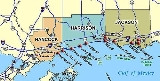
Gautier is a city in Jackson County, Mississippi
, United States
, along the Gulf of Mexico
west of Pascagoula
. It is part of the Pascagoula, Mississippi
Metropolitan Statistical Area
. The population was 11,681 at the 2000 census. In 2002, Gautier annexed land nearly doubling its population to 18,413, according to the [Gautier Comprehensive Plan 2030]. Locally, the name is pronounced as "GO-shay." Descendants of the Gautier family, for whom it was named, still live in the area.
Gautier is a bedroom resort community with two championship golf courses, stately homes, and historic properties surrounded by bayous and wetlands on three sides. The natural environment of Gautier offers many opportunities for recreation and eco-tourism. Due to an abundance of vacant land for development and recent growth trends along the coastal areas, the city's population is expected to increase at a steady rate during the coming years to an estimated 22,788 people by 2025. The Gulf Coast region, of which Gautier is a part, has been considered a relatively high growth area of the State; however, the loss of houses and jobs after Hurricane Katrina caused an outward migration in 2006.
of the Gulf of Mexico
, at the mouth of the West Pascagoula River
.
According to the United States Census Bureau
, the city has a total area of 12.9 square miles (33.4 km²), of which, 12.2 square miles (31.6 km²) of it is land and 0.7 square miles (1.8 km²) of it (5.19%) is water.
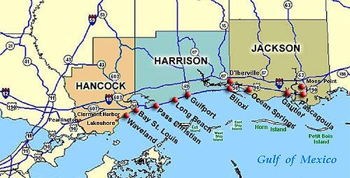 Gautier is located on the Mississippi Gulf Coast in Jackson County on the West Bank of the Pascagoula River, locally known as the "Singing River."
of 2000, there were 11,681 people, 4,260 households, and 3,233 families residing in the city. The population density
was 954.2 people per square mile (368.5/km²). There were 4,597 housing units at an average density of 375.5 per square mile (145.0/km²). The racial makeup of the city was 68.19% White, 27.65% African American, 0.51% Native American, 1.28% Asian, 0.04% Pacific Islander, 0.90% from other races
, and 1.42% from two or more races. Hispanic or Latino of any race were 3.19% of the population.
There were 4,260 households out of which 38.1% had children under the age of 18 living with them, 54.9% were married couples
living together, 17.1% had a female householder with no husband present, and 24.1% were non-families. 19.3% of all households were made up of individuals and 4.5% had someone living alone who was 65 years of age or older. The average household size was 2.73 and the average family size was 3.11.
In the city the population was spread out with 28.4% under the age of 18, 9.8% from 18 to 24, 30.2% from 25 to 44, 23.3% from 45 to 64, and 8.3% who were 65 years of age or older. The median age was 33 years. For every 100 females there were 97.9 males. For every 100 females age 18 and over, there were 94.9 males.
The median income for a household in the city was $41,244, and the median income for a family was $46,835. Males had a median income of $33,474 versus $21,622 for females. The per capita income
for the city was $17,525. About 15.1% of families and 17.3% of the population were below the poverty line, including 28.4% of those under age 18 and 13.6% of those age 65 or over.
that Fernando Upton Gautier (1822–1891) established in 1867, at the mouth of the Pascagoula River Basin still stands, a hallmark of the city that now bears his name. Fernando Upton Gautier established a lucrative sawmill business in the area, and the town grew up from it. Today the town is known for its stately homes nestled between centuries-old Live Oaks and two championship golf courses. The home known by locals as "The Old Place" is still owned by the descendants of Theresa Fayard Gautier (1828–1911) and Fernando Upton Gautier and is currently being used for private and public events. Other historic homes of Gautier include that of Josie Gautier and the current Portas homestead, both Gulf Coastal cottage style homes from the 1890s.
. The main secondary school in Gautier is Gautier High School.
The Jackson County Campus of Mississippi Gulf Coast Community College.
. Many of the coastal homes were either destroyed or flooded. Some of the houses along the coast were built on hills, leaving them with wind damage only. Homes built on the water were completely destroyed, occasionally leaving an intact slab. In a few cases the slabs were cracked in half. One home in particular was built on pylons 13 feet (4 m) above sea level and had the floor ripped out from underneath. Most of northern Gautier, above the railroad tracks, had some wind damage but largely remains intact. Despite the damages caused by Hurricane Katrina, the historic home of Fernando Upton Gautier remains intact and open for business.
Economic Development Post Katrina
The Gulf Opportunity Zone Act (Go-Zone), passed by Congress and signed into law in
December 2005, provided economic development incentives within the forty-nine most
damaged counties of Mississippi and other states affected by Hurricane Katrina, Rita and
Wilma. Incentives included $4.9 billion in tax-exempt private activity bonds, $106 million in
Low Income Housing Tax Credits (LIHTC) and a fifty percent (50%) bonus-depreciation for
property placed in service before the pre-determined deadline. Go Zone tax-exempt private
activity bonds encouraged both economic recovery and growth in South Mississippi. Some of
the largest employers on the Coast including Chevron, Northrop Grumman and PSL-North
America received recovery assistance through the increased bond allocation.
The Mississippi Department of Employment Security (MDES) was awarded a $95 million
National Emergency Grant (NEG) from the federal government to assist in temporary recovery
jobs and to help provide job training. MDES has continued to partner with organizations to
increase employment opportunities along the Coast using Workforce Investment Network, Job
Centers, partnerships and grants to community colleges and proprietary schools.
Jackson County, Mississippi
There were 47,676 households out of which 37.00% had children under the age of 18 living with them, 55.70% were married couples living together, 14.50% had a female householder with no husband present, and 25.10% were non-families. 20.80% of all households were made up of individuals and 7.10% had...
, United States
United States
The United States of America is a federal constitutional republic comprising fifty states and a federal district...
, along the Gulf of Mexico
Gulf of Mexico
The Gulf of Mexico is a partially landlocked ocean basin largely surrounded by the North American continent and the island of Cuba. It is bounded on the northeast, north and northwest by the Gulf Coast of the United States, on the southwest and south by Mexico, and on the southeast by Cuba. In...
west of Pascagoula
Pascagoula, Mississippi
Pascagoula is a city in Jackson County, Mississippi, United States. It is the principal city of the Pascagoula, Mississippi Metropolitan Statistical Area, as a part of the Gulfport–Biloxi–Pascagoula, Mississippi Combined Statistical Area. The population was 26,200 at the 2000 census...
. It is part of the Pascagoula, Mississippi
Pascagoula, Mississippi
Pascagoula is a city in Jackson County, Mississippi, United States. It is the principal city of the Pascagoula, Mississippi Metropolitan Statistical Area, as a part of the Gulfport–Biloxi–Pascagoula, Mississippi Combined Statistical Area. The population was 26,200 at the 2000 census...
Metropolitan Statistical Area
Pascagoula metropolitan area
The Pascagoula Metropolitan Statistical Area is a metropolitan area in the southeastern corner of Mississippi that covers two counties - Jackson and George. As of the 2000 census, the MSA had a population of 150,564. The area was significantly impacted by Hurricane Katrina in 2005. A July 1, 2009...
. The population was 11,681 at the 2000 census. In 2002, Gautier annexed land nearly doubling its population to 18,413, according to the [Gautier Comprehensive Plan 2030]. Locally, the name is pronounced as "GO-shay." Descendants of the Gautier family, for whom it was named, still live in the area.
Gautier is a bedroom resort community with two championship golf courses, stately homes, and historic properties surrounded by bayous and wetlands on three sides. The natural environment of Gautier offers many opportunities for recreation and eco-tourism. Due to an abundance of vacant land for development and recent growth trends along the coastal areas, the city's population is expected to increase at a steady rate during the coming years to an estimated 22,788 people by 2025. The Gulf Coast region, of which Gautier is a part, has been considered a relatively high growth area of the State; however, the loss of houses and jobs after Hurricane Katrina caused an outward migration in 2006.
Organizational structure
The governmental structure of the City of Gautier is relatively young but the area has deep connections to the history of the gulf coast region. The City Manager-Council organizational structure has governed since 1987. Although the 2005 natural disaster slowed growth momentarily, the population of Gautier is expected to grow at a steady rate during the coming decades. The socio-economic demographics of the city is similar to that of Jackson County in terms of income, age, gender and education, although Gautier has a higher rate of college-educated persons. The income and employment of residents benefits greatly from the proximity of strong employment centers in Jackson County.Geography
Gautier is located at 30°22′54"N 88°38′39"W (30.381536, -88.644169), along Mississippi SoundMississippi Sound
The Mississippi Sound is a sound along the Gulf Coast of the United States. It runs east-west along the southern coasts of Mississippi and Alabama, from Waveland, Mississippi, to the Dauphin Island Bridge, a distance of about 145 kilometers...
of the Gulf of Mexico
Gulf of Mexico
The Gulf of Mexico is a partially landlocked ocean basin largely surrounded by the North American continent and the island of Cuba. It is bounded on the northeast, north and northwest by the Gulf Coast of the United States, on the southwest and south by Mexico, and on the southeast by Cuba. In...
, at the mouth of the West Pascagoula River
Pascagoula River
The Pascagoula River is a river, about 80 mi long, in southeastern Mississippi in the United States. The river drains an area of about 8,800 sq mi and flows into Mississippi Sound of the Gulf of Mexico....
.
According to the United States Census Bureau
United States Census Bureau
The United States Census Bureau is the government agency that is responsible for the United States Census. It also gathers other national demographic and economic data...
, the city has a total area of 12.9 square miles (33.4 km²), of which, 12.2 square miles (31.6 km²) of it is land and 0.7 square miles (1.8 km²) of it (5.19%) is water.
Demographics
As of the censusCensus
A census is the procedure of systematically acquiring and recording information about the members of a given population. It is a regularly occurring and official count of a particular population. The term is used mostly in connection with national population and housing censuses; other common...
of 2000, there were 11,681 people, 4,260 households, and 3,233 families residing in the city. The population density
Population density
Population density is a measurement of population per unit area or unit volume. It is frequently applied to living organisms, and particularly to humans...
was 954.2 people per square mile (368.5/km²). There were 4,597 housing units at an average density of 375.5 per square mile (145.0/km²). The racial makeup of the city was 68.19% White, 27.65% African American, 0.51% Native American, 1.28% Asian, 0.04% Pacific Islander, 0.90% from other races
Race (United States Census)
Race and ethnicity in the United States Census, as defined by the Federal Office of Management and Budget and the United States Census Bureau, are self-identification data items in which residents choose the race or races with which they most closely identify, and indicate whether or not they are...
, and 1.42% from two or more races. Hispanic or Latino of any race were 3.19% of the population.
There were 4,260 households out of which 38.1% had children under the age of 18 living with them, 54.9% were married couples
Marriage
Marriage is a social union or legal contract between people that creates kinship. It is an institution in which interpersonal relationships, usually intimate and sexual, are acknowledged in a variety of ways, depending on the culture or subculture in which it is found...
living together, 17.1% had a female householder with no husband present, and 24.1% were non-families. 19.3% of all households were made up of individuals and 4.5% had someone living alone who was 65 years of age or older. The average household size was 2.73 and the average family size was 3.11.
In the city the population was spread out with 28.4% under the age of 18, 9.8% from 18 to 24, 30.2% from 25 to 44, 23.3% from 45 to 64, and 8.3% who were 65 years of age or older. The median age was 33 years. For every 100 females there were 97.9 males. For every 100 females age 18 and over, there were 94.9 males.
The median income for a household in the city was $41,244, and the median income for a family was $46,835. Males had a median income of $33,474 versus $21,622 for females. The per capita income
Per capita income
Per capita income or income per person is a measure of mean income within an economic aggregate, such as a country or city. It is calculated by taking a measure of all sources of income in the aggregate and dividing it by the total population...
for the city was $17,525. About 15.1% of families and 17.3% of the population were below the poverty line, including 28.4% of those under age 18 and 13.6% of those age 65 or over.
History
The gracious homesteadHomesteading
Broadly defined, homesteading is a lifestyle of simple self-sufficiency.-Current practice:The term may apply to anyone who follows the back-to-the-land movement by adopting a sustainable, self-sufficient lifestyle. While land is no longer freely available in most areas of the world, homesteading...
that Fernando Upton Gautier (1822–1891) established in 1867, at the mouth of the Pascagoula River Basin still stands, a hallmark of the city that now bears his name. Fernando Upton Gautier established a lucrative sawmill business in the area, and the town grew up from it. Today the town is known for its stately homes nestled between centuries-old Live Oaks and two championship golf courses. The home known by locals as "The Old Place" is still owned by the descendants of Theresa Fayard Gautier (1828–1911) and Fernando Upton Gautier and is currently being used for private and public events. Other historic homes of Gautier include that of Josie Gautier and the current Portas homestead, both Gulf Coastal cottage style homes from the 1890s.
Education
The City of Gautier is served by the Pascagoula School DistrictPascagoula School District
The Pascagoula School District is a public school district based in Pascagoula, Mississippi .In addition to Pascagoula, the district also serves the city of Gautier as well as the community of Hickory Hills.-High schools:...
. The main secondary school in Gautier is Gautier High School.
The Jackson County Campus of Mississippi Gulf Coast Community College.
Hurricane Katrina
On August 29, 2005 Gautier was one of many cities affected by Hurricane KatrinaHurricane Katrina
Hurricane Katrina of the 2005 Atlantic hurricane season was a powerful Atlantic hurricane. It is the costliest natural disaster, as well as one of the five deadliest hurricanes, in the history of the United States. Among recorded Atlantic hurricanes, it was the sixth strongest overall...
. Many of the coastal homes were either destroyed or flooded. Some of the houses along the coast were built on hills, leaving them with wind damage only. Homes built on the water were completely destroyed, occasionally leaving an intact slab. In a few cases the slabs were cracked in half. One home in particular was built on pylons 13 feet (4 m) above sea level and had the floor ripped out from underneath. Most of northern Gautier, above the railroad tracks, had some wind damage but largely remains intact. Despite the damages caused by Hurricane Katrina, the historic home of Fernando Upton Gautier remains intact and open for business.
Economic Development Post Katrina
The Gulf Opportunity Zone Act (Go-Zone), passed by Congress and signed into law in
December 2005, provided economic development incentives within the forty-nine most
damaged counties of Mississippi and other states affected by Hurricane Katrina, Rita and
Wilma. Incentives included $4.9 billion in tax-exempt private activity bonds, $106 million in
Low Income Housing Tax Credits (LIHTC) and a fifty percent (50%) bonus-depreciation for
property placed in service before the pre-determined deadline. Go Zone tax-exempt private
activity bonds encouraged both economic recovery and growth in South Mississippi. Some of
the largest employers on the Coast including Chevron, Northrop Grumman and PSL-North
America received recovery assistance through the increased bond allocation.
The Mississippi Department of Employment Security (MDES) was awarded a $95 million
National Emergency Grant (NEG) from the federal government to assist in temporary recovery
jobs and to help provide job training. MDES has continued to partner with organizations to
increase employment opportunities along the Coast using Workforce Investment Network, Job
Centers, partnerships and grants to community colleges and proprietary schools.