

Steeles Avenue
Encyclopedia
Steeles Avenue is an east-west street that forms the northern city limit of Toronto
and the southern limit of York Region, Ontario
, Canada. It stretches across the western Greater Toronto Area
from Milborough Townline in Halton Region east to the Scarborough-Pickering limit. It runs for 38.75 km (24.1 mi) within Toronto, between Albion Road and the border with Pickering. It is named after J. C. Steele, who owned a tavern on the street where it intersects with Yonge Street
.
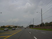
 Steeles Avenue is a two-lane rural road east of York Regional Road 69 (Ninth Line). It becomes a four lane suburban road with bicycle lanes on each side from Kennedy Road to Markham Road, six lanes from Kennedy to Victoria Park Avenue
, and eight lanes from Victoria Park to Highway 404. The area consists of parklands in the east end, a mix of commercial and residential in the middle, and industrial zonings near the west end. Like many other east-west arterial roads within Toronto and York Region, Steeles is divided into an east and west segment by Yonge Street.
East of the Toronto-Pickering
Town Line, it becomes Taunton Road.
West of Albion Road, Steeles Avenue continues into Peel Region, where it is also designated as Peel Regional Road 15. Like the section in Toronto, Steeles Avenue in Brampton has east-west segments, this time on either side of Hurontario Street (former Highway 10). It runs through Brampton and into the Halton Region town of Milton
. After breaking at Appleby Line atop the Niagara Escarpment
due to the presence of the Crawford Lake Conservation Area
, the road resumes just east of Guelph Line and continues until the Milborough Townline on the boundary between Milton and Hamilton
.
 The road is served predominantly by TTC
bus routes 53 Steeles East and 60 Steeles West. Both routes turn away from Steeles upon approaching Yonge Street
. There are several routes serving the portions of the road, including 7 Bathurst, 17 Birchmount, 25 Don Mills, 35A and 35C Jane as well as 35E Jane Express, 37 and 37D Islington, 41 and 41B Keele, 43 Kennedy, 51 Leslie, 57 Midland, 84A and 84D Sheppard West, 97, 97B and 97C Yonge, 98 Willowdale-Senlac, 105C Dufferin North, 117 Alness, 160A Bathurst North, 165, 165D and 165F Weston Road
North, and 191 Highway 27 Rocket. York Region Transit
routes that run along Steeles include 3 (York University
), 10, 88, 12, and 27 (Highway 27
).
Work is underway to extend the Yonge-University-Spadina Line through York University and into Vaughan, which would include a Steeles West station
. MoveOntario 2020
also includes plans to extend the Yonge Line north and add a station at Yonge and Steeles.
In Peel Region, Brampton Transit
and Mississauga Transit
operate several routes that travel along Steeles:
Brampton
Mississauga
Mississauga Transit routes and Brampton Transit routes (3, 4, 4A, 8, 11, 51, 52, 53A and 53B) connect to Shoppers World Terminal at Shoppers World Mall at the northwest corner of Main Street South and Steeles Avenue West. Steeles Avenue East will be made the third arterial for Brampton's Züm
bus rapid transit.
In Halton Region, Milton Transit
operates a single route on a short stretch of Steeles Avenue:
and Bayview Avenue
were resurfaced. The results of the 2009 survey listed Steeles as Ontario's worst road, for the second year in a row.
However in 2010, Steeles Avenue was resurfaced from Yonge Street to Markham Road, with the funds coming from the federal infrastructure stimulus program, and the CAA named it the "Best Road in Ontario".
Toronto
Toronto is the provincial capital of Ontario and the largest city in Canada. It is located in Southern Ontario on the northwestern shore of Lake Ontario. A relatively modern city, Toronto's history dates back to the late-18th century, when its land was first purchased by the British monarchy from...
and the southern limit of York Region, Ontario
Ontario
Ontario is a province of Canada, located in east-central Canada. It is Canada's most populous province and second largest in total area. It is home to the nation's most populous city, Toronto, and the nation's capital, Ottawa....
, Canada. It stretches across the western Greater Toronto Area
Greater Toronto Area
The Greater Toronto Area is the largest metropolitan area in Canada, with a 2006 census population of 5.5 million. The Greater Toronto Area is usually defined as the central city of Toronto, along with four regional municipalities surrounding it: Durham, Halton, Peel, and York...
from Milborough Townline in Halton Region east to the Scarborough-Pickering limit. It runs for 38.75 km (24.1 mi) within Toronto, between Albion Road and the border with Pickering. It is named after J. C. Steele, who owned a tavern on the street where it intersects with Yonge Street
Yonge Street
Yonge Street is a major arterial route connecting the shores of Lake Ontario in Toronto to Lake Simcoe, a gateway to the Upper Great Lakes. It was formerly listed in the Guinness Book of Records as the longest street in the world at , and the construction of Yonge Street is designated an "Event of...
.
Route description
Victoria Park Avenue
Victoria Park Avenue is a major north-south route in eastern Toronto, Ontario, Canada. It marks the border between the Old City of Toronto and Scarborough.-History:Victoria Park Avenue was originally a pioneer road for settlement of Scarborough...
, and eight lanes from Victoria Park to Highway 404. The area consists of parklands in the east end, a mix of commercial and residential in the middle, and industrial zonings near the west end. Like many other east-west arterial roads within Toronto and York Region, Steeles is divided into an east and west segment by Yonge Street.
East of the Toronto-Pickering
Pickering, Ontario
Pickering is a city located in Southern Ontario, Canada immediately east of Toronto in Durham Region. It is part of the Greater Toronto Area, the largest metropolitan area in Canada.- Early Period :...
Town Line, it becomes Taunton Road.
West of Albion Road, Steeles Avenue continues into Peel Region, where it is also designated as Peel Regional Road 15. Like the section in Toronto, Steeles Avenue in Brampton has east-west segments, this time on either side of Hurontario Street (former Highway 10). It runs through Brampton and into the Halton Region town of Milton
Milton, Ontario
Milton is a town in Southern Ontario, Canada, and part of the Halton Region in the Greater Toronto Area. Milton received a tremendous amount of awareness following the release of the results of the 2006 Census, which indicated that Milton is the fastest growing municipality in the Greater Golden...
. After breaking at Appleby Line atop the Niagara Escarpment
Niagara Escarpment
The Niagara Escarpment is a long escarpment, or cuesta, in the United States and Canada that runs westward from New York State, through Ontario, Michigan, Wisconsin and Illinois...
due to the presence of the Crawford Lake Conservation Area
Crawford Lake Conservation Area
Crawford Lake Conservation Area is a conservation area owned and operated by the Conservation Halton near the community of Campbellville in Milton, Regional Municipality of Halton, Ontario, Canada. It is a Regionally Environmentally Sensitive Area, an Ontario Area of Natural and Scientific...
, the road resumes just east of Guelph Line and continues until the Milborough Townline on the boundary between Milton and Hamilton
Hamilton, Ontario
Hamilton is a port city in the Canadian province of Ontario. Conceived by George Hamilton when he purchased the Durand farm shortly after the War of 1812, Hamilton has become the centre of a densely populated and industrialized region at the west end of Lake Ontario known as the Golden Horseshoe...
.
Public transit
Toronto Transit Commission
-Island Ferry:The ferry service to the Toronto Islands was operated by the TTC from 1927 until 1962, when it was transferred to the Metro Parks and Culture department. Since 1998, the ferry service is run by Toronto Parks and Recreation.-Gray Coach:...
bus routes 53 Steeles East and 60 Steeles West. Both routes turn away from Steeles upon approaching Yonge Street
Yonge Street
Yonge Street is a major arterial route connecting the shores of Lake Ontario in Toronto to Lake Simcoe, a gateway to the Upper Great Lakes. It was formerly listed in the Guinness Book of Records as the longest street in the world at , and the construction of Yonge Street is designated an "Event of...
. There are several routes serving the portions of the road, including 7 Bathurst, 17 Birchmount, 25 Don Mills, 35A and 35C Jane as well as 35E Jane Express, 37 and 37D Islington, 41 and 41B Keele, 43 Kennedy, 51 Leslie, 57 Midland, 84A and 84D Sheppard West, 97, 97B and 97C Yonge, 98 Willowdale-Senlac, 105C Dufferin North, 117 Alness, 160A Bathurst North, 165, 165D and 165F Weston Road
Weston Road
Weston Road is a north-south street in west end Toronto, Ontario, Canada. The route is named for the former Village of Weston, which was located near Weston Road and Lawrence Avenue West....
North, and 191 Highway 27 Rocket. York Region Transit
York Region Transit
York Region Transit is the public transit operator in York Region, Ontario, Canada. Its headquarters are in Richmond Hill, at 50 High Tech Road....
routes that run along Steeles include 3 (York University
York University
York University is a public research university in Toronto, Ontario, Canada. It is Canada's third-largest university, Ontario's second-largest graduate school, and Canada's leading interdisciplinary university....
), 10, 88, 12, and 27 (Highway 27
Ontario Highway 27
Highway 27, formerly known as King's Highway 27, was a provincially maintained highway in southern Ontario that is now cared for by the city of Toronto, York Region and Simcoe County. It is considered an undivided expressway in Toronto's municipal expressway network...
).
Work is underway to extend the Yonge-University-Spadina Line through York University and into Vaughan, which would include a Steeles West station
Steeles West (TTC)
Steeles West is a planned station of the Yonge–University–Spadina line of the subway system in Toronto, Ontario, Canada, to be built on its western branch, the Spadina line. If built, it would be a temporary terminus, until the line is extended further to Vaughan Corporate Centre...
. MoveOntario 2020
MoveOntario 2020
MoveOntario 2020 is a plan proposed by the Government of Ontario that would fund 52 rapid-transit projects throughout the Greater Toronto and Hamilton Area in Ontario, Canada.-History:...
also includes plans to extend the Yonge Line north and add a station at Yonge and Steeles.
In Peel Region, Brampton Transit
Brampton Transit
Brampton Transit is public transport bus operator for the City of Brampton in the Regional Municipality of Peel, and within the Greater Toronto Area in Ontario, Canada. Brampton Transit began operations in 1974....
and Mississauga Transit
Mississauga Transit
MiWay , is a public transport agency serving Mississauga, Ontario, Canada. The city's Transportation and Works department is in charge of its operation....
operate several routes that travel along Steeles:
Brampton
- 11 Steeles
- 40 Central Industrial (short section)
- 10 South Industrial (short section)
- 4/4A Chinguacousy
- 51 Steeles West
- 3 McLaughlin
- 8 Centre
- 52 McMurchy
- 53A/B James Potter
Mississauga
- 19 Hurontario
- 102 Intercity Express
- 202 Hurontario Express
Mississauga Transit routes and Brampton Transit routes (3, 4, 4A, 8, 11, 51, 52, 53A and 53B) connect to Shoppers World Terminal at Shoppers World Mall at the northwest corner of Main Street South and Steeles Avenue West. Steeles Avenue East will be made the third arterial for Brampton's Züm
Züm
Züm is a bus rapid transit system for the suburban city of Brampton, Ontario, Canada, northwest of Toronto owned and operated by Brampton Transit. The first phase calls for three corridors operating in mixed traffic, similar to York Region Transit's Viva network...
bus rapid transit.
In Halton Region, Milton Transit
Milton Transit
Milton Transit is the public transit system in the Town of Milton, Ontario, Canada. Milton is in Halton Regional Municipality, part of the Greater Toronto Area....
operates a single route on a short stretch of Steeles Avenue:
- 1 Woodward/Maple
Canadian Automobile Association rating
Steeles Avenue was listed by the CAA as the "worst road in October" for 2006, and as the fifth worst road in October 2007. In October 2008, it was again crowned the worst road in Ontario. Reasons include potholes and general quality of surface. Soon after the results of CAA's survey were made public, some parts of the road between Dufferin StreetDufferin Street
Dufferin Street is a major north-south street in Toronto, Ontario, Canada. It is a concession road, two concessions west of Yonge Street. The street starts at the foot of Lake Ontario, continues north to Toronto's northern boundary with some discontinuities and continues into York Region where it...
and Bayview Avenue
Bayview Avenue
Bayview Avenue is a major north-south route in the Greater Toronto Area of Ontario. North of Toronto, in York Region, Bayview is also designated as York Regional Road 34.-History:...
were resurfaced. The results of the 2009 survey listed Steeles as Ontario's worst road, for the second year in a row.
However in 2010, Steeles Avenue was resurfaced from Yonge Street to Markham Road, with the funds coming from the federal infrastructure stimulus program, and the CAA named it the "Best Road in Ontario".
Landmarks
Landmarks and notable sites along Steeles from west to east| Landmark | Cross street | Notes | Image |
|---|---|---|---|
| Crawford Lake Conservation Area Crawford Lake Conservation Area Crawford Lake Conservation Area is a conservation area owned and operated by the Conservation Halton near the community of Campbellville in Milton, Regional Municipality of Halton, Ontario, Canada. It is a Regionally Environmentally Sensitive Area, an Ontario Area of Natural and Scientific... |
Appleby Line | Interrupts Steeles between Appleby and Guelph Line | |
| Rattlesnake Point Rattlesnake Point (Canada) Rattlesnake Point is an eco-tourism area located in Milton, Ontario, Canada and is owned and operated by Conservation Halton. Spanning roughly one-hundred square kilometres across and near the Niagara Escarpment in Halton Region, the Rattlesnake Point area is home to many golf courses, country... |
Milton | 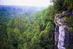 |
|
| Shoppers World Brampton | Hurontario | 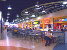 |
|
| Bramalea GO Station | Bramalea Rd | ||
| Wild Water Kingdom Wild Water Kingdom Wild Water Kingdom is located in Brampton, Ontario, and was Canada's largest water-based fun park until Calypso Park was built in 2010. Opened in 1986, the park is located next to the Clairville Reservoir, Clairville Conservation Area and the Humber River... |
Finch Ave | Canada's largest water-based fun park | |
| Dalziel Barn Dalziel barn The Dalziel Barn is an architecturally distinctive log barn built in 1809 and situated in Vaughan just north of Toronto's Black Creek Pioneer Village. Among its features, the barn had a large gable roof with a double slope on one side. Two gable roofed cupolas sat on the ridge... |
Jane St | Historic structure | |
| Black Creek Pioneer Village Black Creek Pioneer Village Black Creek Pioneer Village is a historic site in Toronto, Ontario, Canada, just west of York University and southeast of the Jane and Steeles intersection. It overlooks Black Creek, a tributary of the Humber River. The village is a recreation of life in 19th-century Ontario and gives an idea how... |
Jane St | 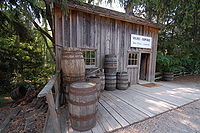 |
|
| York University York University York University is a public research university in Toronto, Ontario, Canada. It is Canada's third-largest university, Ontario's second-largest graduate school, and Canada's leading interdisciplinary university.... |
Keele St | Toronto's second largest university | .jpg) |
| York Stadium York Stadium York Stadium is an outdoor football and soccer stadium located at York University in Toronto, Ontario, Canada. It is the home of the York Lions.-History:... |
Keele St | ||
| Centerpoint Mall | Yonge St | ||
| Steeles VIVA station | Yonge St | 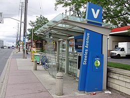 |
|
| Brebeuf College School Brebeuf College School Brebeuf College School is a Roman Catholic all-boys' high school in Toronto founded by the Jesuits in 1963 and associated with the Presentation Brothers since 1984... |
Bayview Ave |  |
|
| Esna-Steeles VIVA station | Esna | 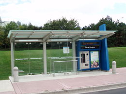 |
|
| Pacific Mall Pacific Mall Pacific Mall is an Asian shopping centre located in Markham, Ontario, Canada. It is located on the northeast side of Steeles Avenue and Kennedy Road, right across the municipal border from the City of Toronto, on the site formerly occupied by Cullen Country Barns. The two entrance roads of the mall... |
Kennedy | ||
| Market Village Market Village Market Village is a mall in Markham, Ontario and is one of the largest Chinese malls in Toronto and in North America. Located at the corner of Steeles Avenue and Kennedy Road, it dominates approximately 325,000 square feet of retail space and consists of over 170 stores.Built by Cedarland... |
Kennedy | 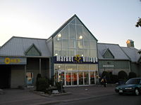 |
|
| Splendid China Tower Splendid China Tower Splendid China Mall is a Chinese-themed ethnic shopping centre located at the southeast corner of Redlea Avenue and Steeles Avenue in the former Toronto municipality of Scarborough, Ontario, Canada. Visar Realty Inc... |
Kennedy | 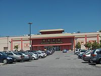 |
|
| Milliken GO Station | Kennedy | ||
| Cedar Brae Golf & Country Club Cedar Brae Golf & Country Club Cedar Brae Golf & Country Club is a private golf club north of Toronto, Ontario in the Town of Markham, Ontario. Situated in the scenic Rouge River Valley in the north-east section of Metropolitan Toronto, Cedar Brae is one of the finest, most picturesque golf clubs in Southern Ontario... |
Staines Rd |