

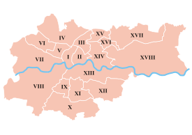
Districts of Kraków
Encyclopedia
Kraków
Kraków also Krakow, or Cracow , is the second largest and one of the oldest cities in Poland. Situated on the Vistula River in the Lesser Poland region, the city dates back to the 7th century. Kraków has traditionally been one of the leading centres of Polish academic, cultural, and artistic life...
is divided into 18 administrative districts, each with a degree of autonomy within the municipal government. The Polish name for such a district is dzielnica
Dzielnica
In the Polish system of local administration, a dzielnica is an administrative subdivision or quarter of a city or town. A dzielnica may have its own elected council , and those of Warsaw each have their own mayor...
.
The oldest neighborhoods of Kraków were incorporated into the city before the late 18th century. They include the Old Town (Stare Miasto), once contained within the city defensive walls
Florian Gate
St. Florian's Gate or Florian Gate in Kraków, Poland, is one of the best-known Polish Gothic towers, and a focal point of Kraków's Old Town. It was built about the 14th century as a rectangular Gothic tower of "wild stone", part of the city fortifications against Turkish attack.-History:The tower,...
and now encircled by the Planty
Planty Park
Planty is one of the largest city parks in Kraków, Poland. It encircles the Stare Miasto , where the Medieval city walls used to stand until the early 19th century. The historic Old Town is not to be confused with the Administrative District No. 1 Stare Miasto extending further east.The park has an...
park; the Wawel
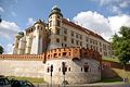
Wawel
Wawel is an architectural complex erected over many centuries atop a limestone outcrop on the left bank of the Vistula River in Kraków, Poland, at an altitude of 228 metres above the sea level. It is a place of great significance to the Polish people. The Royal Castle with an armoury and the...
, which is the site of the Royal Castle and the Cathedral
Wawel Cathedral
The Wawel Cathedral, also known as the Cathedral Basilica of Sts. Stanisław and Vaclav, is a church located on Wawel Hill in Kraków–Poland's national sanctuary. It has a 1,000-year history and was the traditional coronation site of Polish monarchs. It is the Cathedral of the Archdiocese of Kraków...
; Stradom and Kazimierz
Kazimierz
Kazimierz is a historical district of Kraków , best known for being home to a Jewish community from the 14th century until the Second World War.-Early history:...
, the latter originally divided into Christian and Jewish quarters; as well as the ancient town of Kleparz
Kleparz
Kleparz – a neighbourhood in Kraków situated to the north of the Old Town. It was a separate town between 1366 and 1792. It is now part of the Stare Miasto administrative district.-History:...
.
Major districts added in the 19th and 20th centuries include Podgórze
Podgórze
Podgórze is a district of Kraków, Poland, situated on the right bank of the Vistula River. Initially a village at the foot of Lasota Hill was granted city status by the Austrian Emperor Joseph II in 1784 and has become Royal Free City of Podgorze...
, which until 1915 was a separate town on the southern bank of the Vistula, and Nowa Huta
Nowa Huta
Nowa Huta - is the easternmost district of Kraków, Poland, . With more than 200,000 inhabitants it is one of the most populous areas of the city.- History :...
, east of the city centre, built after World War II
World War II
World War II, or the Second World War , was a global conflict lasting from 1939 to 1945, involving most of the world's nations—including all of the great powers—eventually forming two opposing military alliances: the Allies and the Axis...
and incorporated into the city in 1951. Between 1951 and 1973 the city was divided into six districts: Stare Miasto, Zwierzyniec, Kleparz, Grzegórzki, Podgórze and Nowa Huta. From 1973 until the introduction of the present division in 1991 there were four districts: Śródmieście ("City Centre"), Podgórze, Krowodrza and Nowa Huta.
The current division was introduced on 27 March 1991 and revised by Kraków City Council on 19 April 1995. The districts were assigned Roman numerals
Roman numerals
The numeral system of ancient Rome, or Roman numerals, uses combinations of letters from the Latin alphabet to signify values. The numbers 1 to 10 can be expressed in Roman numerals as:...
as well as names. The names and numbers of the 18 districts are now as follows: Stare Miasto (I), Grzegórzki (II), Prądnik Czerwony (III), Prądnik Biały (IV), Krowodrza (V), Bronowice (VI), Zwierzyniec (VII), Dębniki (VIII), Łagiewniki-Borek Fałęcki (IX), Swoszowice (X), Podgórze Duchackie (XI), Bieżanów-Prokocim (XII), Podgórze (XIII), Czyżyny (XIV), Mistrzejowice (XV), Bieńczyce (XVI), Wzgórza Krzesławickie (XVII), and Nowa Huta (XVIII).
Stare Miasto
Wawel
Wawel is an architectural complex erected over many centuries atop a limestone outcrop on the left bank of the Vistula River in Kraków, Poland, at an altitude of 228 metres above the sea level. It is a place of great significance to the Polish people. The Royal Castle with an armoury and the...
castle hill, the former largely Jewish quarter of Kazimierz
Kazimierz
Kazimierz is a historical district of Kraków , best known for being home to a Jewish community from the 14th century until the Second World War.-Early history:...
, and a number of other neighbourhoods surrounding the old town: Nowe Miasto ("New Town"), Nowy Świat ("New World"), Kleparz
Kleparz
Kleparz – a neighbourhood in Kraków situated to the north of the Old Town. It was a separate town between 1366 and 1792. It is now part of the Stare Miasto administrative district.-History:...
, Okół, Piasek, Stradom and Warszawskie (partly in Prądnik Czerwony). Kraków's historic centre, covering the Old Town, Wawel and Kazimierz, was entered on the UNESCO list of World Heritage Site
World Heritage Site
A UNESCO World Heritage Site is a place that is listed by the UNESCO as of special cultural or physical significance...
s in 1978.
Kraków has the most prominent example of an Old Town
Old Town
Old Town is the typical designation of a historic or original core of a city or town. Although the city may be larger in its present form, many cities have redesignated this part of the city to commemorate its origins after thorough renovations...
in the country, because for many centuries, Kraków was the royal capital of Poland, until Sigismund III Vasa
Sigismund III Vasa
Sigismund III Vasa was King of Poland and Grand Duke of Lithuania, a monarch of the united Polish–Lithuanian Commonwealth from 1587 to 1632, and King of Sweden from 1592 until he was deposed in 1599...
relocated the court to Warsaw
Warsaw
Warsaw is the capital and largest city of Poland. It is located on the Vistula River, roughly from the Baltic Sea and from the Carpathian Mountains. Its population in 2010 was estimated at 1,716,855 residents with a greater metropolitan area of 2,631,902 residents, making Warsaw the 10th most...
in 1596.
Medieval Krakow was surrounded by a 1.9 mile (3 km) defensive wall complete with 46 towers and seven main entrances leading through them. The fortifications around the Old Town were erected over the course of two centuries. The current architectural plan
Architectural plan
An architectural plan is a plan for architecture, and the documentation of written and graphic descriptions of the architectural elements of a building project including sketches, drawings and details.- Overview :...
of Stare Miasto—the 13th-century merchants' town—was drawn up following the Tatar invasions
Tatar invasions
The Mongol invasion of Europe from the east took place over the course of three centuries, from the Middle Ages to the early modern period.The terms Tatars or Tartars are applied to nomadic Turkic peoples who, themselves, were conquered by Mongols and incorporated into their horde...
of 1259 and 1287. It features the centrally located Rynek Główny, or Main Square, the largest medieval town square of any European city. There is a number of historic landmarks in its vicinity, such as St. Mary's Basilica
St. Mary's Basilica, Kraków
St. Mary's Basilica , is a Brick Gothic church re-built in the 14th century , adjacent to the Main Market Square in Kraków, Poland...
(Kościół Mariacki), Church of St. Wojciech
Church of St. Wojciech
The Church of St. Adalbert or Church of St. Wojciech , located to the side of the Main Market Square in Old Town, Kraków, is one of the oldest stone churches in Poland...
(St. Adalbert's), Church of St. Barbara, as well as other national treasures. At the center of the plaza, surrounded by kamienice
Kamienica (architecture)
Kamienica is a Polish term describing a type of residential building made of brick or stone, with at least 2 floors. The word is usually used to describe a building which is incorporated with other, similar buildings....
(row houses) and noble
Szlachta
The szlachta was a legally privileged noble class with origins in the Kingdom of Poland. It gained considerable institutional privileges during the 1333-1370 reign of Casimir the Great. In 1413, following a series of tentative personal unions between the Grand Duchy of Lithuania and the Kingdom of...
residences, stands the Renaissance
Renaissance
The Renaissance was a cultural movement that spanned roughly the 14th to the 17th century, beginning in Italy in the Late Middle Ages and later spreading to the rest of Europe. The term is also used more loosely to refer to the historical era, but since the changes of the Renaissance were not...
cloth hall Sukiennice
Sukiennice
The Renaissance Sukiennice in Kraków, Poland, is one of the city's most recognizable icons. It is the central feature of the Main Market Square in the Kraków Old Town . It was once a major centre of international trade. Traveling merchants met there to discuss business and to barter...
(currently housing gift shops, restaurants and merchant stalls) with the National Gallery of Art
National Museum, Kraków
The National Museum in Kraków , established in 1879, is the main branch of Poland's National Museum, which has many permanent collections around the country.-History:...
upstairs. It is flanked by the Town Hall Tower
Town Hall Tower, Kraków
Town Hall Tower in Kraków, Poland is one of the main focal points of the Main Market Square in the Old Town district of Kraków.The Tower is the only remaining part of the old Town Hall demolished in 1820 as part of the city plan to open up the Main Square...
(Wieża ratuszowa).
The whole district is bisected by the Royal Road
Royal Road, Kraków
The Royal Road or Royal Route in Kraków, Poland, begins at the northern end of the medieval Old Town and continues south through the centre of town towards Wawel Hill, where the old royal residence, Wawel Castle, is located...
, the coronation route traversed by the Kings of Poland. The Route begins at St. Florian's Church
St. Florian's Church
The Collegiate Church of St. Florian is a historic church in Kraków, Poland. It stands at the northern end of Matejko Square and the former centre of the mediaeval city of Kleparz, now a district of Kraków. The edifice marks the beginning of the Royal Road....
outside the northern flank of the old city walls in the medieval
Middle Ages
The Middle Ages is a periodization of European history from the 5th century to the 15th century. The Middle Ages follows the fall of the Western Roman Empire in 476 and precedes the Early Modern Era. It is the middle period of a three-period division of Western history: Classic, Medieval and Modern...
suburb of Kleparz; passes the Barbican of Kraków
Barbican of Kraków
The Kraków barbican is a barbican – a fortified outpost once connected to the city walls. It is a historic gateway leading into the Old Town of Kraków, Poland. The barbican is one of the few remaining relics of the complex network of fortifications and defensive barriers that once encircled the...
(Barbakan) built in 1499, and enters Stare Miasto through the Florian Gate
Florian Gate
St. Florian's Gate or Florian Gate in Kraków, Poland, is one of the best-known Polish Gothic towers, and a focal point of Kraków's Old Town. It was built about the 14th century as a rectangular Gothic tower of "wild stone", part of the city fortifications against Turkish attack.-History:The tower,...
. It leads down Floriańska Street through the Main Square, and up Grodzka to Wawel
Wawel
Wawel is an architectural complex erected over many centuries atop a limestone outcrop on the left bank of the Vistula River in Kraków, Poland, at an altitude of 228 metres above the sea level. It is a place of great significance to the Polish people. The Royal Castle with an armoury and the...
, the former seat of Polish royalty overlooking the Vistula river.
In the 19th century most of the Old Town fortifications were demolished. The moat encircling the walls was filled in and turned into a green belt known as Planty Park
Planty Park
Planty is one of the largest city parks in Kraków, Poland. It encircles the Stare Miasto , where the Medieval city walls used to stand until the early 19th century. The historic Old Town is not to be confused with the Administrative District No. 1 Stare Miasto extending further east.The park has an...
.
Grzegórzki
Grzegórzki is Kraków's Administrative District No. II. Until 1990 it was a part of District No. I (Stare Miasto). It borders the districts of Stare Miasto to the west, Prądnik Czerwony to the north, Czyżyny to the east, and Podgórze across the river to the south. It consists of neighbourhoods called Dąbie, Grzegórzki, Olsza (partly in Prądnik Czerwony), Osiedle Oficerskie and Wesoła.Prądnik Czerwony
Prądnik Czerwony ("Red Prądnik") is Kraków's Administrative District No. III. Until 1990 it was a part of District No. I (Stare Miasto). It borders Prądnik Biały to the north-west, Mistrzejowice and Czyżyny to the east, and Stare Miasto and Grzegórzki to the south. It consists of neighbourhoods called Prądnik Czerwony, Olsza (partly in Grzegórzki), RakowiceRakowice, Kraków
Rakowice, formerly a village – is an urban area in Kraków, Poland, part of both: District III Prądnik Czerwony and District XIV Czyżyny. Currently, the neighborhood is heavily urbanized, with a small amount of parks. The predominant structures are apartment buildings and detached houses...
, Śliczna, Ugorek
Rakowice, Kraków
Rakowice, formerly a village – is an urban area in Kraków, Poland, part of both: District III Prądnik Czerwony and District XIV Czyżyny. Currently, the neighborhood is heavily urbanized, with a small amount of parks. The predominant structures are apartment buildings and detached houses...
, Warszawskie (partly in Stare Miasto) and Wieczysta
Rakowice, Kraków
Rakowice, formerly a village – is an urban area in Kraków, Poland, part of both: District III Prądnik Czerwony and District XIV Czyżyny. Currently, the neighborhood is heavily urbanized, with a small amount of parks. The predominant structures are apartment buildings and detached houses...
.
Prądnik Biały
Prądnik Biały ("White Prądnik") is Kraków's Administrative District No. IV, the most northerly district in the city. Until 1990 it was a part of District No. V (Krowodrza). It borders Bronowice, Krowodrza, Stare Miasto and Grzegórzki. It consists of neighbourhoods called Prądnik Biały, Azory, Bronowice Wielkie, Górka Narodowa, Tonie, Witkowice, Żabiniec, Osiedle Krowodrza Górka and Osiedle Witkowice Nowe.Krowodrza
Krowodrza is Kraków's Administrative District No. V, until 24 May 2006 known as Łobzów. It borders Stare Miasto to the east, Zwierzyniec to the south, Bronowice to the west and Prądnik Biały to the north. It consists of the former villages of Czarna Wieś, Krowodrza, Łobzów and Nowa Wieś, the Cichy Kącik estate, and a quarter with housing for students of the AGH University of Science and TechnologyAGH University of Science and Technology
AGH University of Science and Technology is the second largest technical university in Poland, located in Kraków. The university was established in 1919, and was formerly known as the University of Mining and Metallurgy...
.
Bronowice
Bronowice is Kraków's Administrative District No. VI, split in 1990 from District No. V. It is bordered by Prądnik Biały to the north, Krowodrza to the east and Zwierzyniec to the south. It consists of the former villages of Bronowice, Bronowice Małe and Mydlniki, and estates called Osiedle Bronowice Nowe and Osiedle Widok Zarzecze.Zwierzyniec
Zwierzyniec is Kraków's Administrative District No. VII. It borders Bronowice and Krowodrza to the north, Stare Miasto to the east, and Dębniki to the south (across the VistulaVistula
The Vistula is the longest and the most important river in Poland, at 1,047 km in length. The watershed area of the Vistula is , of which lies within Poland ....
). It includes the neighbourhoods (former villages) of Bielany, Chełm, Olszanica, Półwsie Zwierzynieckie, Przegorzały
Przegorzały
Przegorzały – a district in Kraków , located west of the city centre. Originally a separate village, it was first mentioned in 1162 as the property of the Norbertine Sisters. Przegorzały was incorporated into the city of Kraków by the Nazi occupiers in 1941...
, Wola Justowska
Wola Justowska
Wola Justowska is an area belonging to Zwierzyniec District Nº. VII of Kraków, Poland. It was previously a village known as Wola Chełmska until the 16th century. It became part of metropolitan Kraków in 1941....
, Zakamycze and Zwierzyniec, and the Salwator estate. The district contains the Kościuszko Mound
Kosciuszko Mound
Kościuszko Mound in Kraków, Poland, erected by Cracovians in commemoration of the Polish national leader Tadeusz Kościuszko, is an artificial mound modeled after Kraków's prehistoric mounds of Krak and Wanda. A serpentine path leads to the top, approx. above sea level, with a panoramic view of...
and the Blessed Bronisława Chapel. In Bielany there is a Camaldolese
Camaldolese
The Camaldolese monks and nuns are part of the Benedictine family of monastic communities which follow the way of life outlined in the Rule of St. Benedict, written in the 6th century...
monstery, with a nature reserve on the slopes of the hill on which it stands. Bielany is also the site of Kraków's first municipal water supply plant, in use since 1901.
Dębniki
Dębniki is Kraków's Administrative District No. VIII, split in 1990 from Podgórze. It contains the former villages of Bodzów, Dębniki, Kapelanka, Kobierzyn, Koło Tynieckie, Kostrze, Ludwinów, Podgórki Tynieckie, Pychowice, Sidzina, Skotniki, TyniecTyniec
Tyniec is a historic village in Poland on the Vistula river, since 1973 a part of the city of Kraków . Tyniec is notable for its famous Benedictine abbey founded by king Casimir the Restorer in 1044.-See also:...
and Zakrzówek, the neighbourhoods of Kliny Zacisze and Mochnaniec, as well as a number of newly built estates.
Dębniki is a primarily residential area, with diverse architecture, ranging from 19th-century tenements in the area of Rynek Dębnicki (Dębniki Market) to plattenbau
Plattenbau
Plattenbau is the German word for a building whose structure is constructed of large, prefabricated concrete slabs. The word is a compound of Platte and Bau...
blocks of flats in the Podwawelskie and Ruczaj estates and suburban areas of detached houses in the outskirts. In Tyniec is a famous Benedictine
Benedictine
Benedictine refers to the spirituality and consecrated life in accordance with the Rule of St Benedict, written by Benedict of Nursia in the sixth century for the cenobitic communities he founded in central Italy. The most notable of these is Monte Cassino, the first monastery founded by Benedict...
abbey, founded in the 11th century.
The district contains many open spaces, Zakrzówek Nature Park being the most popular of them. A new complex of university buildings, called the Third Campus of the Jagiellonian University
Jagiellonian University
The Jagiellonian University was established in 1364 by Casimir III the Great in Kazimierz . It is the oldest university in Poland, the second oldest university in Central Europe and one of the oldest universities in the world....
, is being developed within the district.
Łagiewniki-Borek Fałęcki
Łagiewniki–Borek Fałęcki is Kraków's Administrative District No. IX, also known as District IX Łagiewniki. Until 1990 it was a part of Podgórze district. It consists of the neighbourhood of Łagiewniki to the north, and Borek Fałęcki to the south. In the north-west is the estate called Osiedle Cegielniana. The district borders Podgórze to the north, Podgórze Duchackie to the east, Swoszowice to the south and Dębniki to the west.Swoszowice
Swoszowice is Kraków's Administrative District No. X. Until 1990 it was a part of PodgórzePodgórze
Podgórze is a district of Kraków, Poland, situated on the right bank of the Vistula River. Initially a village at the foot of Lasota Hill was granted city status by the Austrian Emperor Joseph II in 1784 and has become Royal Free City of Podgorze...
district. It borders Dębniki to the west and Łagiewniki-Borek Fałęcki and Podgórze Duchackie to the north. It includes the Swoszowice spa
Spa
The term spa is associated with water treatment which is also known as balneotherapy. Spa towns or spa resorts typically offer various health treatments. The belief in the curative powers of mineral waters goes back to prehistoric times. Such practices have been popular worldwide, but are...
neighbourhood, as well as the neighbourhoods of Bania, Barycz, Jugowice, Kliny Borkowskie, Kosocice, Lusina, Łysa Góra ("Bald Mount"), Opatkowice, Rajsko, Siarczana Góra ("Sulphur Mount"), Soboniowice, Wróblowice and Zbydniowice.
Podgórze Duchackie
Podgórze Duchackie is Kraków's Administrative District No. XI. Until 24 May 2006 it was known as District XI Wola Duchacka. It was a part of PodgórzePodgórze
Podgórze is a district of Kraków, Poland, situated on the right bank of the Vistula River. Initially a village at the foot of Lasota Hill was granted city status by the Austrian Emperor Joseph II in 1784 and has become Royal Free City of Podgorze...
district until 1990. It borders Podgórze to the north, Bieżanów-Prokocim to the east, Swoszowice to the south and Łagiewniki-Borek Fałęcki to the west. The district contains the neighbourhoods of Bonarka, Kurdwanów, Kurdwanów Nowy ("New Kurdwanów"), Osiedle Piaski Nowe, Osiedle Podlesie, Piaski Wielkie and Wola Duchacka.
Bieżanów-Prokocim
Bieżanów-Prokocim is Kraków's Administrative District No. XII. Until 24 May 2006 it was known as District XII Prokocim-Bieżanów; it was a part of PodgórzePodgórze
Podgórze is a district of Kraków, Poland, situated on the right bank of the Vistula River. Initially a village at the foot of Lasota Hill was granted city status by the Austrian Emperor Joseph II in 1784 and has become Royal Free City of Podgorze...
district until 1990. It borders Podgórze to the north and Podgórze Duchackie to the west. The district takes its name from its constituent neighbourhoods of Bieżanów and Prokocim; it also contains the neighbourhoods of Bieżanów Kolonia, Kaim, Łazy and Rżąka, and a number of residential estates (osiedla
Osiedle
Osiedle is a term used in Poland to denote a designated subdivision of a city or town, or of a dzielnica, with its own council and executive. Like the dzielnica and sołectwo, an osiedle is an auxiliary unit of a gmina. These units are created by decision of the gmina council, and do not have...
): Bieżanów Nowy, Kolejowe, Medyków, Na Kozłówce, Nad Potokiem, Parkowe, Prokocim Nowy and Złocień.
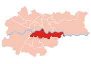
Podgórze
Vistula
The Vistula is the longest and the most important river in Poland, at 1,047 km in length. The watershed area of the Vistula is , of which lies within Poland ....
River. Initially a fishing village at the foot of Lasota Hill, it was granted city status by the Austrian Emperor Joseph II
Joseph II, Holy Roman Emperor
Joseph II was Holy Roman Emperor from 1765 to 1790 and ruler of the Habsburg lands from 1780 to 1790. He was the eldest son of Empress Maria Theresa and her husband, Francis I...
in 1784. From 1784 to 1915 it was an independent township; in 1910 Podgórze was the 13th largest town in Galicia. Formerly a residential and light-industry suburb of Kraków
Kraków
Kraków also Krakow, or Cracow , is the second largest and one of the oldest cities in Poland. Situated on the Vistula River in the Lesser Poland region, the city dates back to the 7th century. Kraków has traditionally been one of the leading centres of Polish academic, cultural, and artistic life...
, it is now a fully integrated part of the city, not a suburb. Historic Podgórze is also officially part of Kraków's old town or 'stare miasto'. Other neighborhoods include the old villages of Płaszów, Rybitwy and Przewóz. Podgórze's total population is listed at 31,599, within an area of 24.6 km2 (as of 31 December 2006).
The oldest man-made structure in Podgórze is the Krakus Mound
Krakus Mound
Krakus Mound is a tumulus located in the Podgórze district of Kraków, Poland; assumed to be the resting place of the legendary prince Krakus. It is located on Lasota Hill, approximately south of the city centre, at an altitude of , with the base diameter of and the height of .The age and the...
on Lasota Hill, believed to be the grave of the legendary prince Krakus
Krakus
Krakus, Krak or Grakch was a legendary Polish prince and founder of Kraków, the ruler of the tribe of Lechitians . Krakus is also credited with building Wawel Castle. The first recorded mention of Krakus, then spelled Grakch, is in the Chronica seu originale regum et principum Poloniae from 1190...
. Carl's Bridge, linking Podgórze with Krakow proper across the Vistula and located between today's Mostowa and Brodzińskiego streets, was built in 1802 and destroyed by a flood just 11 years later in 1813.
A new pedestrian-and-cyclists-only bridge was completed in the summer of 2010 on the site of the 19th century original.
Czyżyny
Czyżyny is Kraków's Administrative District No. XIV. It borders Grzegórzki, Prądnik Czerwony, Mistrzejowice, Bieńczyce, Nowa Huta, and (to the south, across the river) Podgórze. Until 1990 it was part of Nowa Huta district. It includes the former village of Czyżyny, as well as the neighbourhood of Łęg and a number of residential estates.Mistrzejowice
Mistrzejowice is Kraków's Administrative District No. XV. It borders Prądnik Czerwony, Czyżyny, Bieńczyce and Wzgórza Krzesławickie. It includes the neighbourhoods of Batowice, Dziekanowice and Mistrzejowice, and a number of residential estates.Bieńczyce
Bieńczyce is Kraków's Administrative District No. XVI. It borders Czyżyny to the south-west, Mistrzejowice to the north-west, Wzgórza Krzesławickie, to the north-east, and Nowa Huta to the south-east.Wzgórza Krzesławickie
Wzgórza Krzesławickie ("Krzesławice Heights") is Kraków's Administrative District No. XVII. Until 24 May 2006 it was known as District XVII Grębałów. It borders Mistrzejowice and Bieńczyce to the west, and Nowa Huta to the south. The district of Wzgórza Krzesławickie comprises the former villages of Dłubnia, Grębałów, Kantorowice, Krzesławice, LuboczaLubocza, Kraków
Lubocza, formerly a village on the outskirts of Kraków, Poland, is now a borough of District XVII . Lubocza village was first joined to the Nowa Huta District on January 1, 1951...
, Łuczanowice, Wadów, Węgrzynowice, and Zesławice.
Nowa Huta
Nowa Huta (literally "New Steel Mill") is the easternmost district of Kraków, numbered XVIII. With more than 200,000 inhabitants it is one of the most populous areas of the city.The historic area of present-day Nowa Huta is one of the few places in Poland settled continuously since neolithic
Neolithic
The Neolithic Age, Era, or Period, or New Stone Age, was a period in the development of human technology, beginning about 9500 BC in some parts of the Middle East, and later in other parts of the world. It is traditionally considered as the last part of the Stone Age...
. Archeological research has discovered a big Celt
Celt
The Celts were a diverse group of tribal societies in Iron Age and Roman-era Europe who spoke Celtic languages.The earliest archaeological culture commonly accepted as Celtic, or rather Proto-Celtic, was the central European Hallstatt culture , named for the rich grave finds in Hallstatt, Austria....
ic settlement and Poland's oldest Slavic
Slavic peoples
The Slavic people are an Indo-European panethnicity living in Eastern Europe, Southeast Europe, North Asia and Central Asia. The term Slavic represents a broad ethno-linguistic group of people, who speak languages belonging to the Slavic language family and share, to varying degrees, certain...
settlements there. A mound was erected by Vistulans
Vistulans
Vistulans were an early medieval West Slavic tribe inhabiting the land of modern Lesser Poland.From the 1st century and possibly earlier, the Vistulans , were part of the Carpian Tribe, which got its name from the area that they lived in, which was beside the Carpathian Mountain Range...
in the 8th century. According to legend, the Wanda Mound
Wanda Mound
Wanda Mound is a tumulus located in Mogiła in Kraków, Poland. The mound is assumed to be the resting place of the legendary princess Wanda. According to one version of the story, she committed suicide by drowning in the Vistula river to avoid unwanted marriage...
is a tomb of Wanda, daughter of Krak, a mythical founder of Kraków. In the 13th century a Cistercian monastery
Monastery
Monastery denotes the building, or complex of buildings, that houses a room reserved for prayer as well as the domestic quarters and workplace of monastics, whether monks or nuns, and whether living in community or alone .Monasteries may vary greatly in size – a small dwelling accommodating only...
in the village of Mogiła was built.
Nowa Huta was started in 1949 as a separate town near Kraków
Kraków
Kraków also Krakow, or Cracow , is the second largest and one of the oldest cities in Poland. Situated on the Vistula River in the Lesser Poland region, the city dates back to the 7th century. Kraków has traditionally been one of the leading centres of Polish academic, cultural, and artistic life...
on terrain resumed by the Communist Government from former villages of Mogiła, Pleszów and Krzesławice. It was planned as a huge centre of heavy industry. The town was to become an ideal town for the communist propaganda and populated mostly by industrial workers (see: Socialist realism in Poland
Socialist realism in Poland
Socialist realism in Poland was an official Communist doctrine used by the pro-Soviet government in the process of forcible Stalinization of the postwar People's Republic of Poland. The policy was introduced in 1949 by a decree of the Polish United Workers' Party Minister Włodzimierz Sokorski...
). In 1951 it was joined with Kraków as its new district and the following year tramway communication was started.
Since the fall of Communism the city district that was once a showpiece for Stalinism now boasts many tributes to ardent anti-Communism. Streets formerly named after Lenin and the Cuban Revolution
Cuban Revolution
The Cuban Revolution was an armed revolt by Fidel Castro's 26th of July Movement against the regime of Cuban dictator Fulgencio Batista between 1953 and 1959. Batista was finally ousted on 1 January 1959, and was replaced by a revolutionary government led by Castro...
have been renamed to honor Pope John Paul II and the Polish exile leader Władysław Anders. In 2004 Plac Centralny, Nowa Huta's central square which once was home to a giant statue of Lenin - on display at High Chaparral Museum in Hillerstorp
Hillerstorp
Hillerstorp is a locality situated in Gnosjö Municipality, Jönköping County, Sweden with 1,806 inhabitants in 2005. About 40% of the companies in Gnosjö municipality are located in Hillerstorp.Various small industries dominate the landscape...
Sweden, was renamed Ronald Reagan
Ronald Reagan
Ronald Wilson Reagan was the 40th President of the United States , the 33rd Governor of California and, prior to that, a radio, film and television actor....
Central Square (Plac Centralny im. Ronalda Reagana) in honor of the former U.S. President. However, this decision led to many protests, and the traditional name is still widely used.