

Cuyama Valley
Encyclopedia
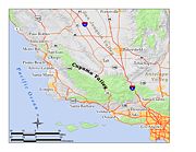
Cuyama River
The Cuyama River is a river in southern San Luis Obispo County, northern Santa Barbara County, and northern Ventura County, in the U.S. state of California. It joins the Sisquoc River forming the Santa Maria River...
in central California
California
California is a state located on the West Coast of the United States. It is by far the most populous U.S. state, and the third-largest by land area...
, in northern Santa Barbara
Santa Barbara County, California
Santa Barbara County is a county located in the southern portion of the U.S. state of California, on the Pacific coast. As of 2010 the county had a population of 423,895. The county seat is Santa Barbara and the largest city is Santa Maria.-History:...
, southern San Luis Obispo
San Luis Obispo County, California
San Luis Obispo County is a county located along the Pacific Ocean in the Central Coast of the U.S. state of California, between Los Angeles and the San Francisco Bay Area. As of the 2010 census its population was 269,637, up from 246,681 at the 2000 census...
, southwestern Kern
Kern County, California
Spreading across the southern end of the California Central Valley, Kern County is the fifth-largest county by population in California. Its economy is heavily linked to agriculture and to petroleum extraction, and there is a strong aviation and space presence. Politically, it has generally...
, and northwestern Ventura
Ventura County, California
Ventura County is a county in the southern part of the U.S. state of California. It is located on California's Pacific coast. It is often referred to as the Gold Coast, and has a reputation of being one of the safest populated places and one of the most affluent places in the country...
counties. It is a sparsely inhabited area containing two significant towns – Cuyama and New Cuyama – and is largely used for ranching, agriculture, and oil and gas production. California State Route 166
California State Route 166
State Route 166 is a state highway in the U.S. state of California. It connects the Central Coast to the southern San Joaquin Valley....
runs along most of the length of the valley, connecting the coastal communities of Santa Maria
Santa Maria, California
Santa Maria is a city in Santa Barbara County, on the Central Coast of California. The 2010 census population was 100,062, putting it ahead of Santa Barbara for the first time and making it the largest city in the county...
and Arroyo Grande
Arroyo Grande, California
Arroyo Grande is a city in San Luis Obispo County, California, United States. The population was 17,252 at the 2010 census.-Geography:Arroyo Grande is a small coastal town with historic, suburban, and rural elements located at...
with the San Joaquin Valley
San Joaquin Valley
The San Joaquin Valley is the area of the Central Valley of California that lies south of the Sacramento – San Joaquin River Delta in Stockton...
near Bakersfield.
Geography
The valley encompasses an area of approximately 300 square miles (777 km²). It is bounded on all sides by mountains, and the Cuyama River escapes west through a narrow canyon to the Pacific Ocean between the Sierra Madre MountainsSierra Madre Mountains (California)
The Sierra Madre Mountains are a mountain range in northern Santa Barbara County, California, USA. They are a portion of the Inner South Coast Ranges, representing the southernmost part, which are themselves part of the Pacific Coast Ranges of western North America. The Sierra Madre Mountains...
on the south and the La Panza Range
La Panza Range
The La Panza Range is a mountain range in the Central Coast of California region in San Luis Obispo County, east of the small town of Santa Margarita. It is one of the California Coast Ranges and in the Los Padres National Forest....
on the north. The headwaters of the Cuyama River are just north of Pine Mountain Summit on California State Route 33
California State Route 33
State Route 33 is a north–south state highway in the U.S. state of California. SR 33 replaced part of U.S. Route 399 in 1964 during the "great renumbering" of routes. In the unincorporated sections of Kern County it is known as the West Side Highway...
, and the valley widens from there to its maximum width near the junction of Route 166 and 33, near the corner of the four counties, and then it narrows again as the river exits to the ocean between the enclosing mountain ranges. The agricultural portions are in the center, near to the major highway intersection and the two towns, where the alluvium is rich and the valley is a wide floodplain.
North of the major portion of the valley is the mile-high Caliente Range
Caliente Range
The Caliente Range is a west-east trending zone of uplift mountains in the Pacific Coast Ranges, in central California. They are home to 5106 foot Caliente Mountain, the highest peak in San Luis Obispo County, California.-Geologic setting:...
, on the other side of which is the Carrizo Plain
Carrizo Plain
The Carrizo Plain is a large enclosed plain, approximately 50 miles long and up to 15 miles across, in southeastern San Luis Obispo County, California, about 100 miles northwest of Los Angeles, California...
. To the east-southeast is the high backcountry of Ventura County, which includes Mount Pinos
Mount Pinos
Mount Pinos is a mountain located in the Los Padres National Forest on the boundary between Ventura and Kern counties in California. The summit is the highest point in Ventura County.- Geography :...
, the highest summit in the region, and the northeastern extremity of the valley ends at the San Andreas Fault
San Andreas Fault
The San Andreas Fault is a continental strike-slip fault that runs a length of roughly through California in the United States. The fault's motion is right-lateral strike-slip...
, which forms a low jumble of hills over which passes Route 166; the southern San Joaquin Valley
San Joaquin Valley
The San Joaquin Valley is the area of the Central Valley of California that lies south of the Sacramento – San Joaquin River Delta in Stockton...
and Bakersfield
Bakersfield, California
Bakersfield is a city near the southern end of the San Joaquin Valley in Kern County, California. It is roughly equidistant between Fresno and Los Angeles, to the north and south respectively....
are on the other side. The Los Padres National Forest
Los Padres National Forest
Los Padres National Forest is a forest located in southern and central California, which includes most of the mountainous land along the California coast from Ventura to Monterey, extending inland...
is adjacent to the Cuyama Valley on the south, east, and northwest; much of the land to the north, including most of the Caliente Range, is owned by the Bureau of Land Management
Bureau of Land Management
The Bureau of Land Management is an agency within the United States Department of the Interior which administers America's public lands, totaling approximately , or one-eighth of the landmass of the country. The BLM also manages of subsurface mineral estate underlying federal, state and private...
(BLM).
Geologically, the valley is an alluvium
Alluvium
Alluvium is loose, unconsolidated soil or sediments, eroded, deposited, and reshaped by water in some form in a non-marine setting. Alluvium is typically made up of a variety of materials, including fine particles of silt and clay and larger particles of sand and gravel...
-filled synclinal
Syncline
In structural geology, a syncline is a fold, with younger layers closer to the center of the structure. A synclinorium is a large syncline with superimposed smaller folds. Synclines are typically a downward fold, termed a synformal syncline In structural geology, a syncline is a fold, with younger...
basin, at an elevation of approximately 2,000 to 2,500 feet (600 to 800 meters). Most of the rocks are sedimentary, and the Miocene
Miocene
The Miocene is a geological epoch of the Neogene Period and extends from about . The Miocene was named by Sir Charles Lyell. Its name comes from the Greek words and and means "less recent" because it has 18% fewer modern sea invertebrates than the Pliocene. The Miocene follows the Oligocene...
-age Monterey Formation
Monterey Formation
The Monterey Formation is an extensive Miocene oil-rich geological sedimentary formation in California, with massive outcroppings of the formation in areas of the California Coast Ranges, Peninsular Ranges, and on some of California's off-shore islands...
outcrops to the south, in the foothills of the Sierra Madre. Pliocene
Pliocene
The Pliocene Epoch is the period in the geologic timescale that extends from 5.332 million to 2.588 million years before present. It is the second and youngest epoch of the Neogene Period in the Cenozoic Era. The Pliocene follows the Miocene Epoch and is followed by the Pleistocene Epoch...
and Pleistocene
Pleistocene
The Pleistocene is the epoch from 2,588,000 to 11,700 years BP that spans the world's recent period of repeated glaciations. The name pleistocene is derived from the Greek and ....
sedimentary formations occur in the foothills along the south side of the valley as well. The large Morales Thrust Fault separates the abruptly-rising block of the Caliente Range from the valley itself on the north. Scenic badlands
Badlands
A badlands is a type of dry terrain where softer sedimentary rocks and clay-rich soils have been extensively eroded by wind and water. It can resemble malpaís, a terrain of volcanic rock. Canyons, ravines, gullies, hoodoos and other such geological forms are common in badlands. They are often...
occur in the upper reaches of the valley, north and northeast of Pine Mountain Summit; they are reachable from Route 33 via Lockwood Valley Road.
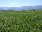
The climate of the valley is semi-arid with hot summers and cool winters. Almost all precipitation occurs in the winter in the form of rain, although snow has fallen on occasion; only five inches of rain falls annually on the valley floor, making it the driest place in coastal Central California. Since the valley is open to the sea, there is occasional marine influence. The principal native vegetation on the valley floor is grassland and scrub, with chaparral
Chaparral
Chaparral is a shrubland or heathland plant community found primarily in the U.S. state of California and in the northern portion of the Baja California peninsula, Mexico...
and oak woodland in the hills to the south.
History
In the early to middle 19th century, the first European settlers arrived, and near the end of the Mexican period of Alta California
Alta California
Alta California was a province and territory in the Viceroyalty of New Spain and later a territory and department in independent Mexico. The territory was created in 1769 out of the northern part of the former province of Las Californias, and consisted of the modern American states of California,...
the valley was split into two land grants along the Cuyama River
Cuyama River
The Cuyama River is a river in southern San Luis Obispo County, northern Santa Barbara County, and northern Ventura County, in the U.S. state of California. It joins the Sisquoc River forming the Santa Maria River...
, the 22,193-acre (89.81 km2) Rancho Cuyama (Rojo)
Rancho Cuyama (Rojo)
Rancho Cuyama was a Mexican land grant in present day eastern Santa Barbara County, California given in 1843 by Governor Manuel Micheltorena to José María Rojo. The grant extended along Cuyama River in the Cuyama Valley, near Cuyama and New Cuyama. There were two Mexican land grants made in the...
in 1843 and the 48,827-acre (197.60 km2) Rancho Cuyama (Lataillade)
Rancho Cuyama (Lataillade)
Rancho Cuyama was a Mexican land grant in present day eastern Santa Barbara County, California given in 1846 by Governor Pío Pico to Cesario Lataillade. The grant extended along Cuyama River in the Cuyama Valley, near Cuyama and New Cuyama. There were two Mexican land grants made in the lower...
in 1846. The main land use in the 19th century was cattle grazing, although some homesteading took place in the late part of the century, especially in the side canyons, where there was more water. In 1939, the first successful water wells using a pumping system were drilled – groundwater is deep in the Cuyama Valley – and the availability of irrigation transformed the valley into an agricultural area.
Little further economic development took place until the discovery of oil in 1948 at the Russell Ranch Oil Field
Russell Ranch Oil Field
The Russell Ranch Oil Field is an oil and gas field in the Cuyama Valley of northern Santa Barbara and southern San Luis Obispo Counties, California, in the United States...
, and more significantly, in 1949 at the much larger South Cuyama Oil Field
South Cuyama Oil Field
The South Cuyama Oil Field is a large oil and gas field in the Cuyama Valley and the adjacent northern foothills of the Sierra Madre Mountains in northeastern Santa Barbara County, California...
. Richfield Oil Company, later part of ARCO
ARCO
Atlantic Richfield Company is an oil company with operations in the United States as well as in Indonesia, the North Sea, and the South China Sea. It has more than 1,300 gas stations in the western part of the United States. ARCO was originally formed by the merger of East Coast-based Atlantic...
, built the town of New Cuyama to house the oil workers and their associated services; they moved the oil pumped from these two fields by pipeline to a refinery near Long Beach. For a brief time in the early 1950s, the Cuyama Valley was the fourth-most productive oil region of California.
As oil production declined – only about two percent of the South Cuyama Field's oil is estimated to remain – the main economic activity in the valley again became agriculture, although with the sharp rise in the price of oil in 2007 and 2008, petroleum exploration has again been of interest. Recently E&B Natural Resources purchased the rights to develop the South Cuyama Oil Field from Hallador Petroleum.
See also
- Ranchos of CaliforniaRanchos of CaliforniaThe Spanish, and later the Méxican government encouraged settlement of territory now known as California by the establishment of large land grants called ranchos, from which the English ranch is derived. Devoted to raising cattle and sheep, the owners of the ranchos attempted to pattern themselves...
- List of Ranchos of California
- Scheideck, CaliforniaScheideck, CaliforniaScheideck, California is an unincorporated community in Ventura County in Southern California within the Cuyama Valley about due north of Ojaiand from Frazier Park in Kern County....