
Caliente Range
Encyclopedia
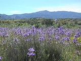
The Caliente Range is a west-east trending zone of uplift mountains in the Pacific Coast Ranges
, in central California
. They are home to 5106 foot (1556 meter) Caliente Mountain
, the highest peak in San Luis Obispo County, California
.
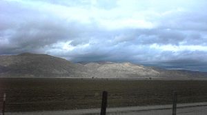
. The Cuyama Valley
separates the Caliente Range from the Sierra Madre Mountains
in neighboring Santa Barbara County to the south. To the northeast, the range is bounded by the Carrizo Plain
. To the northwest, the range is abutted by the La Panza and Santa Lucia Ranges, two northwest-southeast trending units of the Pacific Coast Ranges.
The rocks of the Caliente range are dominated by marine and terrestrial sedimentary deposits laid down over the last 30 million years. Within them are some volcanic units, prominent particularly in the foothills beginning at the Carrizo Plain. These volcanic rocks are of Tertiary
age, and are mostly basalt
.
. Portions are privately owned, and some of the foothills in the northeast are within the protection of the Carrizo Plain National Monument.
The peak is accessible to non-motorized traffic via a gated road. The skeleton of an old cabin remains on the peak. This cabin was a lookout point during the Second World War, as an observer on this prominent peak would have been able to see and report Japanese airplanes coming inland to bomb the important oil fields in Kern County. Dips and rises along the ridgeline road leading to the lookout point equal about 2700 feet (823 m) in elevation gain in the course of the 17 miles (27.4 km) round-trip journey from the locked gate to the peak and back.
of passing storms. Some snow falls on the highest parts of the range.
Pacific Coast Ranges
The Pacific Coast Ranges and the Pacific Mountain System are the series of mountain ranges that stretch along the West Coast of North America from Alaska south to Northern and Central Mexico...
, in central California
California
California is a state located on the West Coast of the United States. It is by far the most populous U.S. state, and the third-largest by land area...
. They are home to 5106 foot (1556 meter) Caliente Mountain
Caliente Mountain
Caliente Mountain is a mountain located in the Southern Coast Ranges of California. The summit, at , is the highest point in San Luis Obispo County and the Caliente Range. The mountain receives a little snowfall during the winter mounths....
, the highest peak in San Luis Obispo County, California
San Luis Obispo County, California
San Luis Obispo County is a county located along the Pacific Ocean in the Central Coast of the U.S. state of California, between Los Angeles and the San Francisco Bay Area. As of the 2010 census its population was 269,637, up from 246,681 at the 2000 census...
.
Geologic setting
The range is an anticlinal structure with a sharp southern boundary defined by the Morales Thrust Fault, along which runs the Cuyama RiverCuyama River
The Cuyama River is a river in southern San Luis Obispo County, northern Santa Barbara County, and northern Ventura County, in the U.S. state of California. It joins the Sisquoc River forming the Santa Maria River...
. The Cuyama Valley
Cuyama Valley
The Cuyama Valley is a valley along the Cuyama River in central California, in northern Santa Barbara, southern San Luis Obispo, southwestern Kern, and northwestern Ventura counties. It is a sparsely inhabited area containing two significant towns – Cuyama and New Cuyama – and is largely used for...
separates the Caliente Range from the Sierra Madre Mountains
Sierra Madre Mountains (California)
The Sierra Madre Mountains are a mountain range in northern Santa Barbara County, California, USA. They are a portion of the Inner South Coast Ranges, representing the southernmost part, which are themselves part of the Pacific Coast Ranges of western North America. The Sierra Madre Mountains...
in neighboring Santa Barbara County to the south. To the northeast, the range is bounded by the Carrizo Plain
Carrizo Plain
The Carrizo Plain is a large enclosed plain, approximately 50 miles long and up to 15 miles across, in southeastern San Luis Obispo County, California, about 100 miles northwest of Los Angeles, California...
. To the northwest, the range is abutted by the La Panza and Santa Lucia Ranges, two northwest-southeast trending units of the Pacific Coast Ranges.
The rocks of the Caliente range are dominated by marine and terrestrial sedimentary deposits laid down over the last 30 million years. Within them are some volcanic units, prominent particularly in the foothills beginning at the Carrizo Plain. These volcanic rocks are of Tertiary
Tertiary
The Tertiary is a deprecated term for a geologic period 65 million to 2.6 million years ago. The Tertiary covered the time span between the superseded Secondary period and the Quaternary...
age, and are mostly basalt
Basalt
Basalt is a common extrusive volcanic rock. It is usually grey to black and fine-grained due to rapid cooling of lava at the surface of a planet. It may be porphyritic containing larger crystals in a fine matrix, or vesicular, or frothy scoria. Unweathered basalt is black or grey...
.
Land use and accessibility
Most of the Caliente Range is public land, owned and managed by the Bureau of Land ManagementBureau of Land Management
The Bureau of Land Management is an agency within the United States Department of the Interior which administers America's public lands, totaling approximately , or one-eighth of the landmass of the country. The BLM also manages of subsurface mineral estate underlying federal, state and private...
. Portions are privately owned, and some of the foothills in the northeast are within the protection of the Carrizo Plain National Monument.
The peak is accessible to non-motorized traffic via a gated road. The skeleton of an old cabin remains on the peak. This cabin was a lookout point during the Second World War, as an observer on this prominent peak would have been able to see and report Japanese airplanes coming inland to bomb the important oil fields in Kern County. Dips and rises along the ridgeline road leading to the lookout point equal about 2700 feet (823 m) in elevation gain in the course of the 17 miles (27.4 km) round-trip journey from the locked gate to the peak and back.
Climate
The higher peaks of the range get more precipitation than the lowlands due to orographic liftOrographic lift
Orographic lift occurs when an air mass is forced from a low elevation to a higher elevation as it moves over rising terrain. As the air mass gains altitude it quickly cools down adiabatically, which can raise the relative humidity to 100% and create clouds and, under the right conditions,...
of passing storms. Some snow falls on the highest parts of the range.