
California State Route 166
Encyclopedia
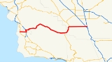
State Route 166 is a state highway
in the U.S. state
of California
. It connects the Central Coast
to the southern San Joaquin Valley
.
This route is part of the California Freeway and Expressway System
and is eligible for the State Scenic Highway System
.
in northwestern Santa Barbara County
and heads east towards the largest city on its eastern journey: Santa Maria
. It then joins with
U.S. Route 101 for the last few miles in Santa Barbara County before crossing the Santa Maria River and splitting off in San Luis Obispo County
. For the next 75 miles (120.7 km), SR 166 crosses the Santa Barbara/San Luis Obispo county line a total of five times. This stretch follows the Cuyama River
through a canyon separating the Sierra Madre Mountains from mountains in San Luis Obispo County, and then opens out into the Cuyama Valley
, passing cattle ranches, going through the Russell Ranch Oil Field
, and passing Aliso Canyon Road, the turnoff to the South Cuyama Oil Field
. On the north during this stretch is the mile-high Caliente Range
, which contains Caliente Mountain
, the highest peak in San Luis Obispo County.
After going through the towns of New Cuyama
and Cuyama
, the highway meets SR 33
north of Ventucopa
. SR 33 and SR 166 merge until reaching Maricopa
, where SR 166 heads due east for its last 20 miles (32.2 km), intersecting with I-5 9 miles (14.5 km) north of the Grapevine
. SR 166 ends at SR 99
in Mettler
, and it is the last exit for both I-5 and SR 99 southbound before they merge near Wheeler Ridge
.
 Before 1964, the portion of SR 166 merged with SR 33 was part of US 399.
In Kern County, Highway 166 is known as the Maricopa Highway. West of Maricopa, where it skirts Santa Barbara and San Luis Obispo counties, it is called the Cuyama Highway. In the cities of Santa Maria and Guadalupe, it is known as Main Street.
From US 101 to the junction of SR 33, 166 is signed as the "CHP Officers Irvine and Stovall Memorial Highway". In February 1998 a large storm swelled the Cuyama River and caused it to wash out a section of the highway. Officers Britt Irvine and Rick Stovall were responding to an early morning call about a truck accident when their CHP cruiser drove off the washed out section, overturned and was buried in mud.http://www.chp.ca.gov/memorial/memorial90.html#1998
{| class=wikitable
!County
!Location
!Postmile
!Exit
!Destinations
!Notes
|-
|rowspan=7|Santa Barbara
SB 0.00-90.99Indicates that the postmile represents the distance along US 101 rather than SR 166.
|rowspan=2|Guadalupe
|0.00
|
|West Main Street
|Continuation beyond SR 1
|-
|0.00
|
|
|
|-
|rowspan=5|Santa Maria
|7.87
|
|
|
|-bgcolor=#ddffdd
|8.93
88.60
|
|
|Interchange; west end of US 101 overlap
|-
|colspan=4 align=center|West end of freeway on US 101
|-
|89.69
|172
|Donovan Road
|
|-
|90.75
|173
|
|
|-
|rowspan=2|San Luis Obispo
SLO 0.00-22.89
|colspan=5 align=center|East end of freeway on US 101
|-
|
|bgcolor=#ddffdd|0.81
13.51
|bgcolor=#ddffdd|
|bgcolor=#ddffdd|
|bgcolor=#ddffdd|Interchange; east end of US 101 overlap
|-
|Santa Barbara
SB 22.89-R34.99
|colspan=5 align=center|No junctions
|-
|San Luis Obispo
SLO R34.99-R51.09
|colspan=5 align=center|No junctions
|-
|Santa Barbara
SLO R51.09-R70.14
|colspan=5 align=center|No junctions
|-
|San Luis Obispo
SLO R70.14-4.95Indicates that the postmile represents the distance along SR 33
rather than SR 166.
|
|bgcolor=#ddffdd|74.72
2.80
|bgcolor=#ddffdd|
|bgcolor=#ddffdd|
|bgcolor=#ddffdd|West end of SR 33 overlap; former US 399 south
|-
|rowspan=7|Kern
KER 0.00-24.62
|
|
|
|Cerro Noroeste Road – Mount Abel Recreation Area
|
|-
|
|
|
|Soda Lake Road – Soda Lake
, California Valley
|Serves Carrizo Plain National Monument
|-
|Maricopa
|bgcolor=#ddffdd|R11.56
0.01
|bgcolor=#ddffdd|
|bgcolor=#ddffdd| – Central District
, Taft
|bgcolor=#ddffdd|East end of SR 33 overlap; former US 399 north
|-
|
|14.86
|
|Old River Road – Old River
|
|-
|
|22.80
|
|
|Interchange
|-
|rowspan=2|Mettler
|24.62
|
|Mettler Frontage Road West – Mettler
|
|-
|24.62
|
|
|Interchange; former US 99
State highway
State highway, state road or state route can refer to one of three related concepts, two of them related to a state or provincial government in a country that is divided into states or provinces :#A...
in the U.S. state
U.S. state
A U.S. state is any one of the 50 federated states of the United States of America that share sovereignty with the federal government. Because of this shared sovereignty, an American is a citizen both of the federal entity and of his or her state of domicile. Four states use the official title of...
of California
California
California is a state located on the West Coast of the United States. It is by far the most populous U.S. state, and the third-largest by land area...
. It connects the Central Coast
Central Coast of California
The Central Coast is an area of California, United States, roughly spanning the area between the Monterey Bay and Point Conception. It extends through Santa Cruz County, San Benito County, Monterey County, San Luis Obispo County, and Santa Barbara County...
to the southern San Joaquin Valley
San Joaquin Valley
The San Joaquin Valley is the area of the Central Valley of California that lies south of the Sacramento – San Joaquin River Delta in Stockton...
.
This route is part of the California Freeway and Expressway System
California Freeway and Expressway System
The California Freeway and Expressway System is a system of existing or planned freeways and expressways in the U.S. state of California. It is defined by the Streets and Highways Code.-List of roads in the system:*State Route 1 *State Route 2...
and is eligible for the State Scenic Highway System
State Scenic Highway System (California)
The State Scenic Highway System is a list of highways, mainly state highways, that have been designated by the California Department of Transportation as scenic highways. The California State Legislature, primarily through Section 263 of the Streets and Highways Code, makes highways eligible for...
.
Route description
Route 166 starts off in GuadalupeGuadalupe, California
Guadalupe is a small city located in Santa Barbara County, California. According to the U.S. Census of 2010, the city has a population of 7,080. It was incorporated as a city on May 19, 1946...
in northwestern Santa Barbara County
Santa Barbara County, California
Santa Barbara County is a county located in the southern portion of the U.S. state of California, on the Pacific coast. As of 2010 the county had a population of 423,895. The county seat is Santa Barbara and the largest city is Santa Maria.-History:...
and heads east towards the largest city on its eastern journey: Santa Maria
Santa Maria, California
Santa Maria is a city in Santa Barbara County, on the Central Coast of California. The 2010 census population was 100,062, putting it ahead of Santa Barbara for the first time and making it the largest city in the county...
. It then joins with
Concurrency (road)
A concurrency, overlap, or coincidence in a road network is an instance of one physical road bearing two or more different highway, motorway, or other route numbers...
U.S. Route 101 for the last few miles in Santa Barbara County before crossing the Santa Maria River and splitting off in San Luis Obispo County
San Luis Obispo County, California
San Luis Obispo County is a county located along the Pacific Ocean in the Central Coast of the U.S. state of California, between Los Angeles and the San Francisco Bay Area. As of the 2010 census its population was 269,637, up from 246,681 at the 2000 census...
. For the next 75 miles (120.7 km), SR 166 crosses the Santa Barbara/San Luis Obispo county line a total of five times. This stretch follows the Cuyama River
Cuyama River
The Cuyama River is a river in southern San Luis Obispo County, northern Santa Barbara County, and northern Ventura County, in the U.S. state of California. It joins the Sisquoc River forming the Santa Maria River...
through a canyon separating the Sierra Madre Mountains from mountains in San Luis Obispo County, and then opens out into the Cuyama Valley
Cuyama Valley
The Cuyama Valley is a valley along the Cuyama River in central California, in northern Santa Barbara, southern San Luis Obispo, southwestern Kern, and northwestern Ventura counties. It is a sparsely inhabited area containing two significant towns – Cuyama and New Cuyama – and is largely used for...
, passing cattle ranches, going through the Russell Ranch Oil Field
Russell Ranch Oil Field
The Russell Ranch Oil Field is an oil and gas field in the Cuyama Valley of northern Santa Barbara and southern San Luis Obispo Counties, California, in the United States...
, and passing Aliso Canyon Road, the turnoff to the South Cuyama Oil Field
South Cuyama Oil Field
The South Cuyama Oil Field is a large oil and gas field in the Cuyama Valley and the adjacent northern foothills of the Sierra Madre Mountains in northeastern Santa Barbara County, California...
. On the north during this stretch is the mile-high Caliente Range
Caliente Range
The Caliente Range is a west-east trending zone of uplift mountains in the Pacific Coast Ranges, in central California. They are home to 5106 foot Caliente Mountain, the highest peak in San Luis Obispo County, California.-Geologic setting:...
, which contains Caliente Mountain
Caliente Mountain
Caliente Mountain is a mountain located in the Southern Coast Ranges of California. The summit, at , is the highest point in San Luis Obispo County and the Caliente Range. The mountain receives a little snowfall during the winter mounths....
, the highest peak in San Luis Obispo County.
After going through the towns of New Cuyama
New Cuyama, California
New Cuyama is a census-designated place in the Cuyama Valley, in Santa Barbara County, California, in the United States. It was named after the Chumash Indian word for "clams", most likely due to the millions of petrified prehistoric clamshell fossils that are found in the surrounding areas...
and Cuyama
Cuyama, California
Cuyama is a census-designated place in Santa Barbara County. California. It is located in the Cuyama Valley, near the Carrizo Plain. The Cuyama River runs adjacent to the town, flowing west towards the Pacific Ocean. Cuyama is surrounded by many apricot, peach, and plum orchards. The ZIP Code is...
, the highway meets SR 33
California State Route 33
State Route 33 is a north–south state highway in the U.S. state of California. SR 33 replaced part of U.S. Route 399 in 1964 during the "great renumbering" of routes. In the unincorporated sections of Kern County it is known as the West Side Highway...
north of Ventucopa
Ventucopa, California
Ventucopa is an unincorporated town in the upper Cuyama Valley of Santa Barbara County, California. It lies on State Route 33 near the eastern bank of the seasonally-dry Cuyama River, about southeast of Cuyama...
. SR 33 and SR 166 merge until reaching Maricopa
Maricopa, California
Maricopa is a city in Kern County, California, United States. Maricopa is located south-southeast of Taft, at an elevation of 883 feet . The population was 1,154 at the 2010 census, up from 1,111 at the 2000 census. Maricopa lies at the junction of Route 166 and Route 33...
, where SR 166 heads due east for its last 20 miles (32.2 km), intersecting with I-5 9 miles (14.5 km) north of the Grapevine
Grapevine, California
Grapevine is an unincorporated community in Kern County, California. At an elevation of 1499 feet , the community is located at the foot of a road grade known as The Grapevine through the Grapevine Canyon to Tejon Pass in the Tehachapi Mountains at the southern end of the San Joaquin Valley along...
. SR 166 ends at SR 99
California State Route 99
California State Route 99 , commonly known as Highway 99 or, simply, as 99 , is a north–south state highway in the U.S. state of California, stretching almost the entire length of the Central Valley...
in Mettler
Mettler, California
Mettler, or Mettler Station, is a heavily Hispanic, low-income unincorporated area and census-designated place in Kern County, California. The population was 136 at the 2010 census, down from 157 at the 2000 census...
, and it is the last exit for both I-5 and SR 99 southbound before they merge near Wheeler Ridge
Wheeler Ridge, California
Wheeler Ridge is an unincorporated community in Kern County, California. It is located south-southeast of Mettler, at an elevation of 955 feet .A post office operated at Wheeler Ridge from 1923 to 1972....
.
In Kern County, Highway 166 is known as the Maricopa Highway. West of Maricopa, where it skirts Santa Barbara and San Luis Obispo counties, it is called the Cuyama Highway. In the cities of Santa Maria and Guadalupe, it is known as Main Street.
From US 101 to the junction of SR 33, 166 is signed as the "CHP Officers Irvine and Stovall Memorial Highway". In February 1998 a large storm swelled the Cuyama River and caused it to wash out a section of the highway. Officers Britt Irvine and Rick Stovall were responding to an early morning call about a truck accident when their CHP cruiser drove off the washed out section, overturned and was buried in mud.http://www.chp.ca.gov/memorial/memorial90.html#1998
Major intersections
- Note: Except where prefixed with a letter, postmiles were measured in 1964, based on the alignment as it existed at that time, and do not necessarily reflect current mileage. The numbers reset at some county lines; the start and end postmiles in each county are given in the county column.
{| class=wikitable
!County
!Location
!Postmile
!Exit
Exit number
An exit number is a number assigned to a road junction, usually an exit from a freeway. It is usually marked on the same sign as the destinations of the exit, as well as a sign in the gore....
!Destinations
!Notes
|-
|rowspan=7|Santa Barbara
Santa Barbara County, California
Santa Barbara County is a county located in the southern portion of the U.S. state of California, on the Pacific coast. As of 2010 the county had a population of 423,895. The county seat is Santa Barbara and the largest city is Santa Maria.-History:...
SB 0.00-90.99Indicates that the postmile represents the distance along US 101 rather than SR 166.
|rowspan=2|Guadalupe
Guadalupe, California
Guadalupe is a small city located in Santa Barbara County, California. According to the U.S. Census of 2010, the city has a population of 7,080. It was incorporated as a city on May 19, 1946...
|0.00
|
|West Main Street
|Continuation beyond SR 1
|-
|0.00
|
|
|
|-
|rowspan=5|Santa Maria
Santa Maria, California
Santa Maria is a city in Santa Barbara County, on the Central Coast of California. The 2010 census population was 100,062, putting it ahead of Santa Barbara for the first time and making it the largest city in the county...
|7.87
|
|
|
|-bgcolor=#ddffdd
|8.93
88.60
|
|
|Interchange; west end of US 101 overlap
|-
|colspan=4 align=center|West end of freeway on US 101
|-
|89.69
|172
|Donovan Road
|
|-
|90.75
|173
|
|
|-
|rowspan=2|San Luis Obispo
San Luis Obispo County, California
San Luis Obispo County is a county located along the Pacific Ocean in the Central Coast of the U.S. state of California, between Los Angeles and the San Francisco Bay Area. As of the 2010 census its population was 269,637, up from 246,681 at the 2000 census...
SLO 0.00-22.89
|colspan=5 align=center|East end of freeway on US 101
|-
|
|bgcolor=#ddffdd|0.81
13.51
|bgcolor=#ddffdd|
|bgcolor=#ddffdd|
|bgcolor=#ddffdd|Interchange; east end of US 101 overlap
|-
|Santa Barbara
Santa Barbara County, California
Santa Barbara County is a county located in the southern portion of the U.S. state of California, on the Pacific coast. As of 2010 the county had a population of 423,895. The county seat is Santa Barbara and the largest city is Santa Maria.-History:...
SB 22.89-R34.99
|colspan=5 align=center|No junctions
|-
|San Luis Obispo
San Luis Obispo County, California
San Luis Obispo County is a county located along the Pacific Ocean in the Central Coast of the U.S. state of California, between Los Angeles and the San Francisco Bay Area. As of the 2010 census its population was 269,637, up from 246,681 at the 2000 census...
SLO R34.99-R51.09
|colspan=5 align=center|No junctions
|-
|Santa Barbara
Santa Barbara County, California
Santa Barbara County is a county located in the southern portion of the U.S. state of California, on the Pacific coast. As of 2010 the county had a population of 423,895. The county seat is Santa Barbara and the largest city is Santa Maria.-History:...
SLO R51.09-R70.14
|colspan=5 align=center|No junctions
|-
|San Luis Obispo
San Luis Obispo County, California
San Luis Obispo County is a county located along the Pacific Ocean in the Central Coast of the U.S. state of California, between Los Angeles and the San Francisco Bay Area. As of the 2010 census its population was 269,637, up from 246,681 at the 2000 census...
SLO R70.14-4.95Indicates that the postmile represents the distance along SR 33
California State Route 33
State Route 33 is a north–south state highway in the U.S. state of California. SR 33 replaced part of U.S. Route 399 in 1964 during the "great renumbering" of routes. In the unincorporated sections of Kern County it is known as the West Side Highway...
rather than SR 166.
|
|bgcolor=#ddffdd|74.72
2.80
|bgcolor=#ddffdd|
|bgcolor=#ddffdd|
|bgcolor=#ddffdd|West end of SR 33 overlap; former US 399 south
|-
|rowspan=7|Kern
Kern County, California
Spreading across the southern end of the California Central Valley, Kern County is the fifth-largest county by population in California. Its economy is heavily linked to agriculture and to petroleum extraction, and there is a strong aviation and space presence. Politically, it has generally...
KER 0.00-24.62
|
|
|
|Cerro Noroeste Road – Mount Abel Recreation Area
|
|-
|
|
|
|Soda Lake Road – Soda Lake
Soda Lake (San Luis Obispo County)
Soda Lake is a shallow, ephemeral, alkali endorheic lake in the Carrizo Plain in southeastern San Luis Obispo County, California. The lake is located on the southwest side of the northern Carrizo Plain, 103 km east of San Luis Obispo. It can be reached by Soda Lake Road, which runs...
, California Valley
California Valley, California
California Valley is an unincorporated community located in the eastern part of San Luis Obispo County, California, in the northern portion of the Carrizo Plain.Located...
|Serves Carrizo Plain National Monument
|-
|Maricopa
Maricopa, California
Maricopa is a city in Kern County, California, United States. Maricopa is located south-southeast of Taft, at an elevation of 883 feet . The population was 1,154 at the 2010 census, up from 1,111 at the 2000 census. Maricopa lies at the junction of Route 166 and Route 33...
|bgcolor=#ddffdd|R11.56
0.01
|bgcolor=#ddffdd|
|bgcolor=#ddffdd| – Central District
Maricopa, California
Maricopa is a city in Kern County, California, United States. Maricopa is located south-southeast of Taft, at an elevation of 883 feet . The population was 1,154 at the 2010 census, up from 1,111 at the 2000 census. Maricopa lies at the junction of Route 166 and Route 33...
, Taft
Taft, California
Taft is a city in the foothills at the extreme southwestern edge of the San Joaquin Valley, in Kern County, California. Taft is located west-southwest of Bakersfield, at an elevation of 955 feet . The population was 9,327 at the 2010 census...
|bgcolor=#ddffdd|East end of SR 33 overlap; former US 399 north
|-
|
|14.86
|
|Old River Road – Old River
Old River, California
Old River is an unincorporated community in Kern County, California. It is located southwest of Bakersfield, at an elevation of 344 feet .The settlement was founded in the 1870s and named from the old Kern River bed....
|
|-
|
|22.80
|
|
|Interchange
|-
|rowspan=2|Mettler
Mettler, California
Mettler, or Mettler Station, is a heavily Hispanic, low-income unincorporated area and census-designated place in Kern County, California. The population was 136 at the 2010 census, down from 157 at the 2000 census...
|24.62
|
|Mettler Frontage Road West – Mettler
Mettler, California
Mettler, or Mettler Station, is a heavily Hispanic, low-income unincorporated area and census-designated place in Kern County, California. The population was 136 at the 2010 census, down from 157 at the 2000 census...
|
|-
|24.62
|
|
|Interchange; former US 99