
Cumberland Mountain State Park
Encyclopedia
Cumberland Mountain State Park is a state park
in Cumberland County, Tennessee, in the southeastern United States. The park consists of 1720 acres (7 km²) situated around Byrd Lake, a man-made lake created by the impoundment of Byrd Creek in the 1930s. The park is set amidst an environmental microcosm of the Cumberland Plateau
and provides numerous recreational activities, including an 18-hole Bear Trace golf course.
Cumberland Mountain State Park began as part of the greater Cumberland Homesteads
Project, a New Deal
-era initiative by the Resettlement Administration
that helped relocate poverty-stricken families on the Cumberland Plateau to small farms centered around what is now the Cumberland Homestead community. The families of Homestead built the park with help from the Civilian Conservation Corps
and the Works Progress Administration
.
The park was deeded to the state of Tennessee
in 1938. Alvin C. York served as the park's superintendent until 1940, when he resigned to advise on the filming of Sergeant York
.
 Cumberland Mountain State Park is situated atop the Cumberland Plateau approximately halfway between the plateau's Walden Ridge
escarpment to the east and the plateau's western escarpment to the west. The southern fringe of the Crab Orchard Mountains
rise just over 5 miles (8 km) to the east, and the northern tip of the Sequatchie Valley
is located roughly 10 miles (16.1 km) to the south. The city of Crossville
is located immediately north of the park.
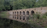
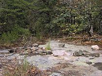
Byrd Creek, the park's major drainage, flows eastward from the hills to the west for approximately 5 miles (8 km) before veering north at its confluence with Coon Hollow Branch. The Byrd Creek Dam, which is located immediately north of this confluence, retains a reservoir that covers approximately 50 acre (0.202343 km²). Beyond the dam, Byrd Creek absorbs Threemile Creek, which flows from the west, and continues eastward for another 10 miles (16.1 km) before emptying into Daddys Creek (a tributary of the Obed River
) near Crab Orchard
. Cumberland Mountain State Park forms a semicircle around Byrd Creek and Threemile Creek, with Byrd Lake being the eastern or "closed" half of the circle.
The park's main entrance is located along Tennessee State Route 419 (Pigeon Ridge Road) just west of Homestead. U.S. Route 127
, which intersects TN-419 at Homestead, connects the area with Crossville and Interstate 40
to the north and the Sequatchie Valley to the south. Tennessee State Route 68, which also intersects US-127 at Homestead, connects the area to Spring City
in the Tennessee Valley to the east.
, the U.S. government established the Subsistence Homesteads Project to aide poverty-stricken families by relocating them to small farms. The government essentially provided low-interest loans that helped families acquire and clear land, build houses and outbuildings, and plant crops. Shortly after the project was established, several businessmen and political leaders from across Tennessee convened and drafted a proposal to have a homesteads project established in the Cumberland Plateau region, which had been particularly hard hit by the Depression when dozens of coal mines in the region were forced to close. The Division of Subsistence Homesteads accepted the proposal in January 1934, and established Cumberland Homesteads, Inc. to oversee the project. The new firm chose a 27000 acres (109.3 km²) tract south of Crossville for the location of the project's farms and communal structures. The Civil Works Administration
hired several hundred Crossvillians to clear and prepare the land for the homesteads, helping to ease the Depression in Cumberland County. In 1935, 250 families were selected for the project from over 1,500 applicants. Each family was given a plot of up to 50 acre (0.202343 km²) upon which to establish a small farm.
Part of the Cumberland Homesteads Project called for the construction of a recreational area near the center of the homesteads. Two New Deal agencies, the Works Progress Administration
and the Civilian Conservation Corps
, arrived in the area in 1934 to build the recreational area's facilities. Company 3464 of the CCC, under the direction of the National Park Service
, began the construction of Byrd Creek Dam in 1935 and completed it in 1938, effectively creating the 50 acre (0.202343 km²) Byrd Lake. The dam, like many of the Homestead structures, is constructed of a native sandstone
commonly called Crab Orchard Stone. At a height of 28 feet (8.5 m) and length of 319 feet (97.2 m), the dam is the largest masonry project ever completed by the CCC. CCC Company 3464, assisted by Company 1471, continued to work at the park until 1941, building trails, picnic areas, cabins, a boathouse, a bathhouse, and other structures.
The Mill House Lodge, located near the dam, was originally built to house a gristmill
that would serve the Cumberland Homesteaders. A group of local Quakers
were brought in to construct the mill, although opposition from local mills— who considered a federally-subsidized mill unfair competition— forced Cumberland Homesteads to nix the project. The mill house had been completed, but the waterwheel and grinding mechanisms were never installed.
The State of Tennessee acquired the park in 1938, and the park officially opened in 1940. Numerous new facilities were constructed at the park between 1948 and 1962, and a new visitor center and swimming pool were built in the 1980s. An 18-hole "Bear Trace" golf course— one of five Bear Traces designed for the State of Tennessee by golfer Jack Nicklaus
— opened at Cumberland Mountain State Park in 1998. In 1988, many of the park's original buildings were listed on the National Register of Historic Places
as part of the Cumberland Homesteads Historic District.
 Cumberland Mountain State Park currently maintains 37 rustic cabins, each of which can accommodate 4 to 10 people, depending on size. The Mill House Lodge can accommodate 16 people. There are a total of 147 campsites at the park's campgrounds, and one backcountry campsite located along the Cumberland Overnight Trail.
Recreational facilities include an olympic-sized swimming pool, picnic pavilions, playgrounds, four tennis courts, horseshoe pits, and shuffleboard, basketball, badminton, and volleyball courts. The Bear Trace golf course is a 6900 yards (6,309.4 m), par 72 course open year-round. Byrd Lake provides fishing and paddleboating opportunities.
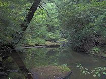
Several miles of hiking trails meander through the park, mostly following Byrd Creek and adjacent hills. The 5 miles (8 km) Pioneer Trail loops through the hemlock
forest along the shores of Byrd Lake and Byrd Lake's headwaters. The 1 miles (1.6 km) Cumberland Plateau Trail is a self-guided interpretive trail that loops through a diverse forest stand downstream from the dam. The Byrd Creek Trail is a 2.1 miles (3.4 km) extension of the Cumberland Plateau Trail that loops around the banks of Byrd Creek. The Cumberland Overnight Trail is a 6 miles (9.7 km) extension of the Byrd Creek Trail that winds through the hills flanking Threemile Creek. The backcountry campsite is located in a cedar flat near the overnight trail's halfway point.
Visitors can also tour an original homesteads house which has been furnished to appear as during the Depression.
State park
State parks are parks or other protected areas managed at the federated state level within those nations which use "state" as a political subdivision. State parks are typically established by a state to preserve a location on account of its natural beauty, historic interest, or recreational...
in Cumberland County, Tennessee, in the southeastern United States. The park consists of 1720 acres (7 km²) situated around Byrd Lake, a man-made lake created by the impoundment of Byrd Creek in the 1930s. The park is set amidst an environmental microcosm of the Cumberland Plateau
Cumberland Plateau
The Cumberland Plateau is the southern part of the Appalachian Plateau. It includes much of eastern Kentucky and western West Virginia, part of Tennessee, and a small portion of northern Alabama and northwest Georgia . The terms "Allegheny Plateau" and the "Cumberland Plateau" both refer to the...
and provides numerous recreational activities, including an 18-hole Bear Trace golf course.
Cumberland Mountain State Park began as part of the greater Cumberland Homesteads
Cumberland Homesteads
Cumberland Homesteads is a community located in Cumberland County, Tennessee, USA. Established by the New Deal-era Division of Subsistence Homesteads in 1934, the community was envisioned by federal planners as a model of cooperative living for the region's distressed farmers, coal miners, and...
Project, a New Deal
New Deal
The New Deal was a series of economic programs implemented in the United States between 1933 and 1936. They were passed by the U.S. Congress during the first term of President Franklin D. Roosevelt. The programs were Roosevelt's responses to the Great Depression, and focused on what historians call...
-era initiative by the Resettlement Administration
Resettlement Administration
The Resettlement Administration was a U.S. federal agency that, between April 1935 and December 1936, relocated struggling urban and rural families to communities planned by the federal government....
that helped relocate poverty-stricken families on the Cumberland Plateau to small farms centered around what is now the Cumberland Homestead community. The families of Homestead built the park with help from the Civilian Conservation Corps
Civilian Conservation Corps
The Civilian Conservation Corps was a public work relief program that operated from 1933 to 1942 in the United States for unemployed, unmarried men from relief families, ages 18–25. A part of the New Deal of President Franklin D...
and the Works Progress Administration
Works Progress Administration
The Works Progress Administration was the largest and most ambitious New Deal agency, employing millions of unskilled workers to carry out public works projects, including the construction of public buildings and roads, and operated large arts, drama, media, and literacy projects...
.
The park was deeded to the state of Tennessee
Tennessee
Tennessee is a U.S. state located in the Southeastern United States. It has a population of 6,346,105, making it the nation's 17th-largest state by population, and covers , making it the 36th-largest by total land area...
in 1938. Alvin C. York served as the park's superintendent until 1940, when he resigned to advise on the filming of Sergeant York
Sergeant York
Sergeant York is a 1941 biographical film about the life of Alvin York, the most-decorated American soldier of World War I. It was directed by Howard Hawks and was the highest-grossing film of the year....
.
Geographical setting
Walden Ridge
Walden Ridge is a mountain ridge and escarpment located in Tennessee, in the United States. It marks the eastern edge of the Cumberland Plateau and is generally considered part of it. Walden Ridge is about long, running generally north-south...
escarpment to the east and the plateau's western escarpment to the west. The southern fringe of the Crab Orchard Mountains
Crab Orchard Mountains
The Crab Orchard Mountains are a rugged, detached range of the southern Cumberland Mountains. They are situated in East Tennessee atop the Cumberland Plateau just west of the plateau's eastern escarpment, and comprise parts of Morgan, Anderson, and Cumberland counties. The Crab Orchard Mountains...
rise just over 5 miles (8 km) to the east, and the northern tip of the Sequatchie Valley
Sequatchie Valley
Sequatchie Valley is a relatively long and narrow valley in the U.S. state of Tennessee and, in some definitions, Alabama. It is generally considered to be part of the Cumberland Plateau region of the Appalachian Mountains; it was probably formed by erosion of a compression anticline, rather than...
is located roughly 10 miles (16.1 km) to the south. The city of Crossville
Crossville, Tennessee
Crossville is a city in and the county seat of Cumberland County, Tennessee, United States. The population was 10,795 at the 2010 Census.-Geography:Crossville is located at...
is located immediately north of the park.
Byrd Creek, the park's major drainage, flows eastward from the hills to the west for approximately 5 miles (8 km) before veering north at its confluence with Coon Hollow Branch. The Byrd Creek Dam, which is located immediately north of this confluence, retains a reservoir that covers approximately 50 acre (0.202343 km²). Beyond the dam, Byrd Creek absorbs Threemile Creek, which flows from the west, and continues eastward for another 10 miles (16.1 km) before emptying into Daddys Creek (a tributary of the Obed River
Obed River
Obed River is a stream draining a part of the Cumberland Plateau in Tennessee. It, and particularly its tributaries, are important streams for whitewater enthusiasts....
) near Crab Orchard
Crab Orchard, Tennessee
Crab Orchard is a city in Cumberland County, Tennessee, United States. The population was 838 at the 2000 census.-Geography:Crab Orchard is located at . The town is situated atop the Cumberland Plateau in a gap amidst the Crab Orchard Mountains, a sub-range of the Cumberland Mountains...
. Cumberland Mountain State Park forms a semicircle around Byrd Creek and Threemile Creek, with Byrd Lake being the eastern or "closed" half of the circle.
The park's main entrance is located along Tennessee State Route 419 (Pigeon Ridge Road) just west of Homestead. U.S. Route 127
U.S. Route 127
U.S. Route 127 is a long north–south United States highway in the eastern half of the United States. The southern terminus of the route is at U.S. Route 27 in Chattanooga, Tennessee. The northern terminus is at Interstate 75 near Grayling, Michigan...
, which intersects TN-419 at Homestead, connects the area with Crossville and Interstate 40
Interstate 40
Interstate 40 is the third-longest major east–west Interstate Highway in the United States, after I-90 and I-80. Its western end is at Interstate 15 in Barstow, California; its eastern end is at a concurrency of U.S. Route 117 and North Carolina Highway 132 in Wilmington, North Carolina...
to the north and the Sequatchie Valley to the south. Tennessee State Route 68, which also intersects US-127 at Homestead, connects the area to Spring City
Spring City, Tennessee
Spring City is a town in Rhea County, Tennessee, United States. The population was 2,025 at the 2000 census.-Geography:Spring City is located at ....
in the Tennessee Valley to the east.
History
In 1933, at the height of the Great DepressionGreat Depression
The Great Depression was a severe worldwide economic depression in the decade preceding World War II. The timing of the Great Depression varied across nations, but in most countries it started in about 1929 and lasted until the late 1930s or early 1940s...
, the U.S. government established the Subsistence Homesteads Project to aide poverty-stricken families by relocating them to small farms. The government essentially provided low-interest loans that helped families acquire and clear land, build houses and outbuildings, and plant crops. Shortly after the project was established, several businessmen and political leaders from across Tennessee convened and drafted a proposal to have a homesteads project established in the Cumberland Plateau region, which had been particularly hard hit by the Depression when dozens of coal mines in the region were forced to close. The Division of Subsistence Homesteads accepted the proposal in January 1934, and established Cumberland Homesteads, Inc. to oversee the project. The new firm chose a 27000 acres (109.3 km²) tract south of Crossville for the location of the project's farms and communal structures. The Civil Works Administration
Civil Works Administration
The Civil Works Administration was established by the New Deal during the Great Depression to create manual labor jobs for millions of unemployed. The jobs were merely temporary, for the duration of the hard winter. Harry L. Hopkins was put in charge of the organization. President Franklin D...
hired several hundred Crossvillians to clear and prepare the land for the homesteads, helping to ease the Depression in Cumberland County. In 1935, 250 families were selected for the project from over 1,500 applicants. Each family was given a plot of up to 50 acre (0.202343 km²) upon which to establish a small farm.
Part of the Cumberland Homesteads Project called for the construction of a recreational area near the center of the homesteads. Two New Deal agencies, the Works Progress Administration
Works Progress Administration
The Works Progress Administration was the largest and most ambitious New Deal agency, employing millions of unskilled workers to carry out public works projects, including the construction of public buildings and roads, and operated large arts, drama, media, and literacy projects...
and the Civilian Conservation Corps
Civilian Conservation Corps
The Civilian Conservation Corps was a public work relief program that operated from 1933 to 1942 in the United States for unemployed, unmarried men from relief families, ages 18–25. A part of the New Deal of President Franklin D...
, arrived in the area in 1934 to build the recreational area's facilities. Company 3464 of the CCC, under the direction of the National Park Service
National Park Service
The National Park Service is the U.S. federal agency that manages all national parks, many national monuments, and other conservation and historical properties with various title designations...
, began the construction of Byrd Creek Dam in 1935 and completed it in 1938, effectively creating the 50 acre (0.202343 km²) Byrd Lake. The dam, like many of the Homestead structures, is constructed of a native sandstone
Sandstone
Sandstone is a sedimentary rock composed mainly of sand-sized minerals or rock grains.Most sandstone is composed of quartz and/or feldspar because these are the most common minerals in the Earth's crust. Like sand, sandstone may be any colour, but the most common colours are tan, brown, yellow,...
commonly called Crab Orchard Stone. At a height of 28 feet (8.5 m) and length of 319 feet (97.2 m), the dam is the largest masonry project ever completed by the CCC. CCC Company 3464, assisted by Company 1471, continued to work at the park until 1941, building trails, picnic areas, cabins, a boathouse, a bathhouse, and other structures.
The Mill House Lodge, located near the dam, was originally built to house a gristmill
Gristmill
The terms gristmill or grist mill can refer either to a building in which grain is ground into flour, or to the grinding mechanism itself.- Early history :...
that would serve the Cumberland Homesteaders. A group of local Quakers
Religious Society of Friends
The Religious Society of Friends, or Friends Church, is a Christian movement which stresses the doctrine of the priesthood of all believers. Members are known as Friends, or popularly as Quakers. It is made of independent organisations, which have split from one another due to doctrinal differences...
were brought in to construct the mill, although opposition from local mills— who considered a federally-subsidized mill unfair competition— forced Cumberland Homesteads to nix the project. The mill house had been completed, but the waterwheel and grinding mechanisms were never installed.
The State of Tennessee acquired the park in 1938, and the park officially opened in 1940. Numerous new facilities were constructed at the park between 1948 and 1962, and a new visitor center and swimming pool were built in the 1980s. An 18-hole "Bear Trace" golf course— one of five Bear Traces designed for the State of Tennessee by golfer Jack Nicklaus
Jack Nicklaus
Jack William Nicklaus , nicknamed "The Golden Bear", is an American professional golfer. He won 18 career major championships on the PGA Tour over a span of 25 years and is widely regarded as one of the greatest professional golfers of all time. In addition to his 18 Majors, he was runner-up a...
— opened at Cumberland Mountain State Park in 1998. In 1988, many of the park's original buildings were listed on the National Register of Historic Places
National Register of Historic Places
The National Register of Historic Places is the United States government's official list of districts, sites, buildings, structures, and objects deemed worthy of preservation...
as part of the Cumberland Homesteads Historic District.
The park today
Recreational facilities include an olympic-sized swimming pool, picnic pavilions, playgrounds, four tennis courts, horseshoe pits, and shuffleboard, basketball, badminton, and volleyball courts. The Bear Trace golf course is a 6900 yards (6,309.4 m), par 72 course open year-round. Byrd Lake provides fishing and paddleboating opportunities.
Several miles of hiking trails meander through the park, mostly following Byrd Creek and adjacent hills. The 5 miles (8 km) Pioneer Trail loops through the hemlock
Tsuga
Tsuga is a genus of conifers in the family Pinaceae. The common name hemlock is derived from a perceived similarity in the smell of its crushed foliage to that of the unrelated plant poison hemlock....
forest along the shores of Byrd Lake and Byrd Lake's headwaters. The 1 miles (1.6 km) Cumberland Plateau Trail is a self-guided interpretive trail that loops through a diverse forest stand downstream from the dam. The Byrd Creek Trail is a 2.1 miles (3.4 km) extension of the Cumberland Plateau Trail that loops around the banks of Byrd Creek. The Cumberland Overnight Trail is a 6 miles (9.7 km) extension of the Byrd Creek Trail that winds through the hills flanking Threemile Creek. The backcountry campsite is located in a cedar flat near the overnight trail's halfway point.
Cumberland Homesteads Tower Museum
The Cumberland Homesteads Tower Museum, located 1 miles (1.6 km) from the park, recalls the development of the Cumberland Homestead Community of the 1930s. The octagonal Cumberlands Tower was originally constructed by the CCC between 1937-1938 using Crab Orchard Stone to house the Cumberland Homesteads offices. The tower features a water tank and a 97-step stairway to the lookout platform at the top with views of the park. The base features a museum at its base with exhibits about the history of the homesteads project and its residents, and period displays.Visitors can also tour an original homesteads house which has been furnished to appear as during the Depression.
External links
- Cumberland Mountain State Park — official site
- Friends of Cumberland Mountain State Park
- Cumberlands Homesteads Tower Museum - official site
- Cumberland Homesteads Museum - Tennessee History for Kids article
- History of the Cumberlands Homesteads