
Obed River
Encyclopedia

Stream
A stream is a body of water with a current, confined within a bed and stream banks. Depending on its locale or certain characteristics, a stream may be referred to as a branch, brook, beck, burn, creek, "crick", gill , kill, lick, rill, river, syke, bayou, rivulet, streamage, wash, run or...
draining a part of the Cumberland Plateau
Cumberland Plateau
The Cumberland Plateau is the southern part of the Appalachian Plateau. It includes much of eastern Kentucky and western West Virginia, part of Tennessee, and a small portion of northern Alabama and northwest Georgia . The terms "Allegheny Plateau" and the "Cumberland Plateau" both refer to the...
in Tennessee
Tennessee
Tennessee is a U.S. state located in the Southeastern United States. It has a population of 6,346,105, making it the nation's 17th-largest state by population, and covers , making it the 36th-largest by total land area...
. It, and particularly its tributaries, are important streams for whitewater
Whitewater
Whitewater is formed in a rapid, when a river's gradient increases enough to disturb its laminar flow and create turbulence, i.e. form a bubbly, or aerated and unstable current; the frothy water appears white...
enthusiasts.
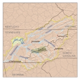
The Obed River rises in Cumberland County, Tennessee, just south of Crossville
Crossville, Tennessee
Crossville is a city in and the county seat of Cumberland County, Tennessee, United States. The population was 10,795 at the 2010 Census.-Geography:Crossville is located at...
. It is bridged by U.S. Highway 70 between downtown Crossville and the municipal airport
Airport
An airport is a location where aircraft such as fixed-wing aircraft, helicopters, and blimps take off and land. Aircraft may be stored or maintained at an airport...
, and meets its confluence with the Little Obed River
Little Obed River
The Little Obed River is a ten mile long stream in the Cumberland Plateau in Cumberland County, Tennessee.The Little Obed rises east of Crossville and from near its source flows in a deep gorge that it has cut into the rocks capping the plateau, primarily sandstones of the Pennsylvanian Period...
near a bridge on U.S. Highway 70N and an abandoned railroad bridge which was formerly part of the rail system linking Nashville
Nashville, Tennessee
Nashville is the capital of the U.S. state of Tennessee and the county seat of Davidson County. It is located on the Cumberland River in Davidson County, in the north-central part of the state. The city is a center for the health care, publishing, banking and transportation industries, and is home...
and Knoxville
Knoxville, Tennessee
Founded in 1786, Knoxville is the third-largest city in the U.S. state of Tennessee, U.S.A., behind Memphis and Nashville, and is the county seat of Knox County. It is the largest city in East Tennessee, and the second-largest city in the Appalachia region...
. Shortly thereafter, it is bridged by U.S. Highway 127 and Interstate 40
Interstate 40
Interstate 40 is the third-longest major east–west Interstate Highway in the United States, after I-90 and I-80. Its western end is at Interstate 15 in Barstow, California; its eastern end is at a concurrency of U.S. Route 117 and North Carolina Highway 132 in Wilmington, North Carolina...
. Except during periods of very high flow, the stream is scarcely visible from these bridges because of the depth of its gorge.
From there the stream enters a rather remote area. After several miles it is bridged by State Route 298 (Genesis Road). From this point to its mouth it is designated as a "National Wild and Scenic River" along with Clear Creek and Daddys Creek.
The direction of flow changes gradually from largely south to north to largely west to east. Shortly after crossing into Morgan County it receives the flow of Daddys Creek, which is a good whitewater rafting stream. Downstream from this is the mouth of Clear Creek. This stream is also part of the Obed River "Wild and Scenic" designation; like Daddys Creek, it too is a premiere whitewater stream during periods of high flow.
Several miles below the mouth of Clear Creek is the confluence with the Emory River
Emory River
The Emory River is a stream draining a portion of Tennessee's Cumberland Plateau.-Hydrography:The Emory River rises on the slopes of Frozen Head and Bird Mountain, prominent peaks in that part of the Cumberland Plateau in Morgan County, Tennessee. Frozen Head is the focus of a Tennessee state park...
. Although the Obed River is the larger of the two, the river takes the name of the Emory River below the confluence.