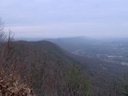
Walden Ridge
Encyclopedia

Mountain
Image:Himalaya_annotated.jpg|thumb|right|The Himalayan mountain range with Mount Everestrect 58 14 160 49 Chomo Lonzorect 200 28 335 52 Makalurect 378 24 566 45 Mount Everestrect 188 581 920 656 Tibetan Plateaurect 250 406 340 427 Rong River...
ridge
Ridge
A ridge is a geological feature consisting of a chain of mountains or hills that form a continuous elevated crest for some distance. Ridges are usually termed hills or mountains as well, depending on size. There are several main types of ridges:...
and escarpment
Escarpment
An escarpment is a steep slope or long cliff that occurs from erosion or faulting and separates two relatively level areas of differing elevations.-Description and variants:...
located in Tennessee
Tennessee
Tennessee is a U.S. state located in the Southeastern United States. It has a population of 6,346,105, making it the nation's 17th-largest state by population, and covers , making it the 36th-largest by total land area...
, in the United States
United States
The United States of America is a federal constitutional republic comprising fifty states and a federal district...
. It marks the eastern edge of the Cumberland Plateau
Cumberland Plateau
The Cumberland Plateau is the southern part of the Appalachian Plateau. It includes much of eastern Kentucky and western West Virginia, part of Tennessee, and a small portion of northern Alabama and northwest Georgia . The terms "Allegheny Plateau" and the "Cumberland Plateau" both refer to the...
and is generally considered part of it. Walden Ridge is about 74 miles (119.1 km) long, running generally north-south. Its highest point is at Hinch Mountain (near Crossville
Crossville, Tennessee
Crossville is a city in and the county seat of Cumberland County, Tennessee, United States. The population was 10,795 at the 2010 Census.-Geography:Crossville is located at...
), which reaches 3048 feet (929 m) above sea level.
Sequatchie Valley
Sequatchie Valley
Sequatchie Valley is a relatively long and narrow valley in the U.S. state of Tennessee and, in some definitions, Alabama. It is generally considered to be part of the Cumberland Plateau region of the Appalachian Mountains; it was probably formed by erosion of a compression anticline, rather than...
, a long valley in the Cumberland Plateau, is located just west of the southern part of Walden Ridge. The Sequatchie River
Sequatchie River
The Sequatchie River is a waterway that drains the Sequatchie Valley, a large valley in the Cumberland Plateau in Middle Tennessee.-Hydrography:The Sequatchie River's source is a massive spring which flows out of Head of Sequatchie Spring...
runs through the valley. To the east of Walden Ridge are the Ridge-and-valley Appalachians
Ridge-and-valley Appalachians
The Ridge-and-Valley Appalachians, also called the Ridge and Valley Province or the Valley and Ridge Appalachians, are a physiographic province of the larger Appalachian division and are also a belt within the Appalachian Mountains extending from southeastern New York through northwestern New...
and the Tennessee River
Tennessee River
The Tennessee River is the largest tributary of the Ohio River. It is approximately 652 miles long and is located in the southeastern United States in the Tennessee Valley. The river was once popularly known as the Cherokee River, among other names...
. Walden Ridge is significantly higher than the Cumberland Plateau, and its eastern slope, descending over 1000 feet (304.8 m) from the plateau to the Tennessee Valley
Tennessee Valley
The Tennessee Valley is the drainage basin of the Tennessee River and is largely within the U.S. state of Tennessee. It stretches from southwest Kentucky to northwest Georgia and from northeast Mississippi to the mountains of Virginia and North Carolina...
, is steep and escarpment-like. Sometimes Walden Ridge is called the "Cumberland Escarpment". Geologically, Walden Ridge continues south in Georgia
Georgia (U.S. state)
Georgia is a state located in the southeastern United States. It was established in 1732, the last of the original Thirteen Colonies. The state is named after King George II of Great Britain. Georgia was the fourth state to ratify the United States Constitution, on January 2, 1788...
and Alabama
Alabama
Alabama is a state located in the southeastern region of the United States. It is bordered by Tennessee to the north, Georgia to the east, Florida and the Gulf of Mexico to the south, and Mississippi to the west. Alabama ranks 30th in total land area and ranks second in the size of its inland...
as Sand Mountain
Sand Mountain (Alabama)
Sand Mountain is a sandstone plateau in northeastern Alabama and northwestern Georgia. It is part of the southern tip of the Appalachian mountain chain. Geologically a continuation of Walden Ridge, Sand Mountain is part of the Cumberland Plateau, separated from the main portion of the plateau by...
.
The section of Walden Ridge that is visible from the Chattanooga area is often colloquially referred to as "Signal Mountain" due to the presence of the small town of Signal Mountain, Tennessee
Signal Mountain, Tennessee
Signal Mountain is a town in Hamilton County, Tennessee, United States. The town is a suburb of Chattanooga and is located on Walden Ridge, a land mass often mistakenly referred to as "Signal Mountain" itself...
nearby, the proliferation of broadcasting towers on its eastern edge, and the area's use by early nineteenth century Native Americans (and later Civil War Soldiers) as a signal point toward Lookout Mountain south across the Tennessee River.
Being part of the Cumberland Plateau, Walden Ridge is also part of the Appalachian Plateau
Appalachian Plateau
The Appalachian Plateau is the western part of the Appalachian mountains, stretching from New York and Alabama. The plateau is a second level United States physiographic region....
physiographic province.
According to the USGS, variant names of Walden Ridge include Waldens Ridge, Walldenns Ridge, Wallens Ridge, Walden's Ridge, and Walden Ridge Plateau.

