

Sequatchie Valley
Encyclopedia
United States
The United States of America is a federal constitutional republic comprising fifty states and a federal district...
state of Tennessee
Tennessee
Tennessee is a U.S. state located in the Southeastern United States. It has a population of 6,346,105, making it the nation's 17th-largest state by population, and covers , making it the 36th-largest by total land area...
and, in some definitions, Alabama
Alabama
Alabama is a state located in the southeastern region of the United States. It is bordered by Tennessee to the north, Georgia to the east, Florida and the Gulf of Mexico to the south, and Mississippi to the west. Alabama ranks 30th in total land area and ranks second in the size of its inland...
. It is generally considered to be part of the Cumberland Plateau
Cumberland Plateau
The Cumberland Plateau is the southern part of the Appalachian Plateau. It includes much of eastern Kentucky and western West Virginia, part of Tennessee, and a small portion of northern Alabama and northwest Georgia . The terms "Allegheny Plateau" and the "Cumberland Plateau" both refer to the...
region of the Appalachian Mountains
Appalachian Mountains
The Appalachian Mountains #Whether the stressed vowel is or ,#Whether the "ch" is pronounced as a fricative or an affricate , and#Whether the final vowel is the monophthong or the diphthong .), often called the Appalachians, are a system of mountains in eastern North America. The Appalachians...
; it was probably formed by erosion of a compression anticline
Anticline
In structural geology, an anticline is a fold that is convex up and has its oldest beds at its core. The term is not to be confused with antiform, which is a purely descriptive term for any fold that is convex up. Therefore if age relationships In structural geology, an anticline is a fold that is...
, rather than rifting
Rift valley
A rift valley is a linear-shaped lowland between highlands or mountain ranges created by the action of a geologic rift or fault. This action is manifest as crustal extension, a spreading apart of the surface which is subsequently further deepened by the forces of erosion...
process as had been formerly theorized.
The Sequatchie River
Sequatchie River
The Sequatchie River is a waterway that drains the Sequatchie Valley, a large valley in the Cumberland Plateau in Middle Tennessee.-Hydrography:The Sequatchie River's source is a massive spring which flows out of Head of Sequatchie Spring...
drains the valley in Tennessee, flowing south to southwest from the southern part of Cumberland County, Tennessee to the Tennessee River
Tennessee River
The Tennessee River is the largest tributary of the Ohio River. It is approximately 652 miles long and is located in the southeastern United States in the Tennessee Valley. The river was once popularly known as the Cherokee River, among other names...
near the Alabama border.
Geologically, the Sequatchie Valley continues south of the Tennessee River into central Alabama. The Tennessee River flows through the Alabama portion of the valley to the vicinity of Guntersville, Alabama
Guntersville, Alabama
Guntersville is a city in Marshall County, Alabama, United States and is included in the Huntsville-Decatur Combined Statistical Area. At the 2010 census, the population of the city was 8,197. The city is the county seat of Marshall County. Guntersville is located in a HUBZone as identified by the...
. The valley continues south of Guntersville, where it is called Browns Valley, drained by Browns Creek (Thornbury 1965:148). Although this whole valley is geologically the same, the name Sequatchie is commonly used only for the Tennessee portion of the valley, through which the Sequatchie River flows.
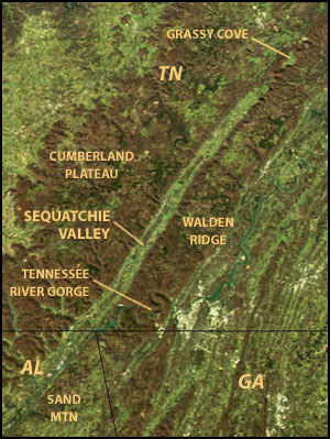
A distinctive feature of the Sequatchie Valley is its straightness. From its northern end to its geological southern end at Browns Valley, the valley is almost perfectly straight. It is over 150 miles (240 km) long in the geologic sense and about 65 miles (105 km) long as the valley of the Sequatchie River. Its width is about 3–5 miles (5–8 km).
The valley is bounded on either side by escarpments of the Cumberland Plateau. The portion of the plateau east of the valley is relatively narrow and known as Walden Ridge
Walden Ridge
Walden Ridge is a mountain ridge and escarpment located in Tennessee, in the United States. It marks the eastern edge of the Cumberland Plateau and is generally considered part of it. Walden Ridge is about long, running generally north-south...
in Tennessee. To the west the plateau is simply called the Cumberland Plateau. In Bledsoe County, Tennessee a section of the west side escarpment is called Little Mountain
Little Mountain (Tennessee)
Little Mountain is a summit in the U.S. state of Tennessee. Part of the Cumberland Plateau, Little Mountain is a section of the Cumberland Escarpment separating the Cumberland Plateau from the Sequatchie Valley....
, which also marks the Tennessee Valley Divide
Tennessee Valley Divide
The Tennessee Valley Divide is the eastern and southern boundary of the drainage basin of the Tennessee River and its tributaries.The Tennessee Valley Divide begins near the northeasternmost source of the Tennessee River, in the vicinity of Bluefield, West Virginia. From there, the divide...
. In Alabama the plateau to the east of the valley is called Sand Mountain
Sand Mountain (Alabama)
Sand Mountain is a sandstone plateau in northeastern Alabama and northwestern Georgia. It is part of the southern tip of the Appalachian mountain chain. Geologically a continuation of Walden Ridge, Sand Mountain is part of the Cumberland Plateau, separated from the main portion of the plateau by...
, while that to the west is Gunters Mountain
Gunters Mountain
Gunters Mountain is a plateau-type summit in the U.S. state of Alabama. Part of the Cumberland Plateau, Gunters Mountain separates the Cumberland Plateau from the valley of the Tennessee River....
.
At its northern end, the Sequatchie Valley is marked by a more mountainous portion of the Cumberland Plateau known as the Crab Orchard Mountains
Crab Orchard Mountains
The Crab Orchard Mountains are a rugged, detached range of the southern Cumberland Mountains. They are situated in East Tennessee atop the Cumberland Plateau just west of the plateau's eastern escarpment, and comprise parts of Morgan, Anderson, and Cumberland counties. The Crab Orchard Mountains...
. Between the main Crab Orchard Mountains and the Sequatchie Valley there is another valley, called Grassy Cove
Grassy Cove
Grassy Cove is an enclosed valley in Cumberland County, Tennessee, in the southeastern United States. The valley is notable for its karst formations, which have been designated a National Natural Landmark...
, located several miles north of Sequatchie Valley. Grassy Cove is a karst
KARST
Kilometer-square Area Radio Synthesis Telescope is a Chinese telescope project to which FAST is a forerunner. KARST is a set of large spherical reflectors on karst landforms, which are bowlshaped limestone sinkholes named after the Kras region in Slovenia and Northern Italy. It will consist of...
valley which, through underground erosion, should eventually become part of Sequatchie Valley (Thornbury 1965:149). Another, smaller karst valley, Bat Town Cove, is forming northeast of Grassy Cove, which may also grow and eventually become part of Sequatchie Valley.
The Tennessee section of Sequatchie Valley contains the towns of Pikeville
Pikeville, Tennessee
Pikeville is a city in Bledsoe County, Tennessee, United States. The population was 1,781 at the 2000 census. It is also the county seat of Bledsoe County.-Geography:...
, Dunlap
Dunlap, Tennessee
Dunlap is a city in Sequatchie County, Tennessee, United States. The population was 4,173 at the 2000 census. It is the county seat of Sequatchie County.Dunlap is part of the Chattanooga, TN–GA Metropolitan Statistical Area.-Geography:...
, Whitwell
Whitwell, Tennessee
Whitwell is a city in Marion County, Tennessee, United States. The population was 1,660 at the 2000 census. It is part of the Chattanooga, TN–GA Metropolitan Statistical Area.-History:...
, Jasper
Jasper, Tennessee
Jasper is a town in Marion County, Tennessee. The population was 3,214 at the 2000 census. It is the county seat of Marion County.Jasper is part of the Chattanooga, TN–GA Metropolitan Statistical Area.-History:...
, and, on the Tennessee River, South Pittsburg
South Pittsburg, Tennessee
South Pittsburg is a city in Marion County, Tennessee, United States. It is part of the Chattanooga, TN–GA Metropolitan Statistical Area. The population was 3,295 at the 2000 census. South Pittsburg is home to the National Cornbread Festival.-History:...
. Towns in the Alabama portion of the geologic valley include Bridgeport
Bridgeport, Alabama
Bridgeport is a small city in Jackson County, Alabama, United States. At the time of 2000 census the population was 2,728. Bridgeport is included in the Huntsville-Decatur Combined Statistical Area.-History:...
, Scottsboro
Scottsboro, Alabama
Scottsboro is a city in Jackson County, Alabama, United States. As of the 2010 census, the population of the city is 14,770. Named for its founder Robert Scott, the city is the county seat of Jackson County....
, Guntersville
Guntersville, Alabama
Guntersville is a city in Marshall County, Alabama, United States and is included in the Huntsville-Decatur Combined Statistical Area. At the 2010 census, the population of the city was 8,197. The city is the county seat of Marshall County. Guntersville is located in a HUBZone as identified by the...
, and, around the southern end, Blountsville
Blountsville, Alabama
Blountsville is a town in Blount County, Alabama, United States. Blount County was created by the Alabama Territorial legislature on 1818 Feb. 6, from land ceded to the Federal government by the Creek Nation on 1814 Aug. 9. It was named for Gov. Willie G. Blount of Tennessee, who provided...
.