
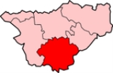
Crewe and Nantwich
Encyclopedia
Non-metropolitan district
Non-metropolitan districts, or colloquially shire districts, are a type of local government district in England. As created, they are sub-divisions of non-metropolitan counties in a so-called "two-tier" arrangement...
with borough status
Borough status in the United Kingdom
Borough status in the United Kingdom is granted by royal charter to local government districts in England, Wales and Northern Ireland. The status is purely honorary, and does not give any additional powers to the council or inhabitants of the district...
in Cheshire
Cheshire
Cheshire is a ceremonial county in North West England. Cheshire's county town is the city of Chester, although its largest town is Warrington. Other major towns include Widnes, Congleton, Crewe, Ellesmere Port, Runcorn, Macclesfield, Winsford, Northwich, and Wilmslow...
, England. It had a population (2001 census) of 111,007. It contained 69 civil parishes and one unparished area: the town of Crewe
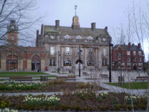
Crewe
Crewe is a railway town within the unitary authority area of Cheshire East and the ceremonial county of Cheshire, England. According to the 2001 census the urban area had a population of 67,683...
.
Creation
The Borough of Crewe and Nantwich was created on 1 April 1974 under the Local Government Act 1972Local Government Act 1972
The Local Government Act 1972 is an Act of Parliament in the United Kingdom that reformed local government in England and Wales on 1 April 1974....
by the merger of the borough of Crewe
Crewe
Crewe is a railway town within the unitary authority area of Cheshire East and the ceremonial county of Cheshire, England. According to the 2001 census the urban area had a population of 67,683...
(an industrial town), the urban district of Nantwich
Nantwich
Nantwich is a market town and civil parish in the Borough of Cheshire East and the ceremonial county of Cheshire, England. The town gives its name to the parliamentary constituency of Crewe and Nantwich...
(a much smaller market town), and Nantwich Rural District
Nantwich Rural District
Nantwich Rural District was a division of Cheshire until 1974, when it merged with the Nantwich and Crewe Urban districts to create the borough of Crewe and Nantwich....
.
Civil Parishes
The former Crewe Municipal BoroughCrewe
Crewe is a railway town within the unitary authority area of Cheshire East and the ceremonial county of Cheshire, England. According to the 2001 census the urban area had a population of 67,683...
was unparished, but the rest of the Crewe and Nantwich district included the following civil parishes;
- ActonActon, CheshireActon is a small village and civil parish lying immediately west of the town of Nantwich in the unitary authority of Cheshire East and the ceremonial county of...
- AlprahamAlprahamAlpraham is a village and civil parish in the unitary authority of Cheshire East and the ceremonial county of Cheshire, England. It is on the A51 road, between Nantwich and Chester, and is about seven miles north-west of Nantwich...
- Aston juxta MondrumAston juxta MondrumAston juxta Mondrum is a village and civil parish in the unitary authority of Cheshire East and the ceremonial county of Cheshire, England. It is about four miles north of Nantwich. The civil parish also includes part of Worleston village.-History:...
- AudlemAudlemAudlem is a large village and civil parish located in the unitary authority of Cheshire East and the ceremonial county of Cheshire in the north west of England, approximately south of Nantwich. Close to the border with the neighbouring county of Shropshire, the village is eight miles east of...
- Austerson
- BaddileyBaddileyBaddiley is a scattered settlement and civil parish in the unitary authority of Cheshire East and the ceremonial county of Cheshire, England. The civil parish also includes the north-western part of the village of Ravensmoor , as well as the small settlements of Baddiley Hulse, Batterley Hill, and...
- BaddingtonBaddingtonBaddington is a civil parish in the unitary authority of Cheshire East and the ceremonial county of Cheshire, England, which lies immediately to the south west of Nantwich and north of Audlem...
- BarthomleyBarthomleyBarthomley is a village and ancient parish, and is now a civil parish in the unitary authority of Cheshire East and the ceremonial county of Cheshire, England. According to the 2001 census the parish had a population of 202. The village is situated near junction 16 of the M6 motorway and by the...
- BasfordBasford, CheshireBasford is a civil parish in the unitary authority of Cheshire East and the ceremonial county of Cheshire, England, just south of Crewe. According to the 2001 census it had a population of 266.-Governance:...
- BathertonBathertonBatherton is a hamlet and civil parish in the unitary authority of Cheshire East and the ceremonial county of Cheshire, England. It is just south of Nantwich, and according to the 2001 census had a population of 36.-Governance:...
- BickertonBickerton, CheshireBickerton is a village and civil parish in the unitary authority of Cheshire East and the ceremonial county of Cheshire, England, about eight miles north of Whitchurch in Shropshire. The parish also includes the small settlement of Gallantry Bank, with a total population of over 200...
- BlakenhallBlakenhall, CheshireBlakenhall is a village and civil parish in the unitary authority of Cheshire East and the ceremonial county of Cheshire, England, about seven miles south-east of Nantwich...
- BridgemereBridgemereBridgemere is a village and civil parish in the unitary authority of Cheshire East and the ceremonial county of Cheshire, England. It is around south east of Nantwich and west of Stoke-on-Trent. The southern boundary of the parish is on the border with Shropshire...
- BrindleyBrindleyBrindley is a village and civil parish in the unitary authority of Cheshire East and the ceremonial county of Cheshire, England. The village lies 3¾ miles to the west of Nantwich. The parish also includes the settlements of Brindley Lea, Ryders Bank and part of Radmore Green, with a total...
- Broomhall
- BuertonBuerton, Crewe and NantwichBuerton is a village at and civil parish in the unitary authority of Cheshire East and the ceremonial county of Cheshire, England, about 7 miles south of the town of Nantwich and 1½ miles east of the village of Audlem, on the border with Shropshire...
- BulkeleyBulkeleyBulkeley is a village and civil parish in the unitary authority of Cheshire East and the ceremonial county of Cheshire, England. The village is situated at on the A534 about 9 miles west of Nantwich. The civil parish also includes the small settlement of Bulkelehay at , with a total population...
- BunburyBunbury, CheshireBunbury is a village and civil parish in the unitary authority of Cheshire East and the ceremonial county of Cheshire, England, south of Tarporley, north west of Nantwich, and on the Shropshire Union Canal...
- BurlandBurlandBurland is a village and civil parish in the unitary authority of Cheshire East and the ceremonial county of Cheshire, England, about 2½ miles west of Nantwich. The civil parish also includes the small settlements of Burland Lower Green, Burland Upper Green, Hollin Green and Stoneley Green, as well...
- CalveleyCalveleyCalveley is a village and civil parish in the unitary authority of Cheshire East and the ceremonial county of Cheshire, England. The village lies 5½ miles to the north west of Nantwich. The parish also includes parts of the settlements of Barrets Green and Wardle Bank. Nearby villages include...
- Checkley cum WrinehillCheckley cum WrinehillCheckley cum Wrinehill is a civil parish in the unitary authority of Cheshire East and the ceremonial county of Cheshire, England, which lies adjacent to the boundaries with Shropshire and Staffordshire. The hamlet of Checkley lies to the south east of Crewe and to the west of Newcastle-under-Lyme...
- CholmondeleyCholmondeley, CheshireCholmondeley is a civil parish in the unitary authority of Cheshire East and the ceremonial county of Cheshire, England, which lies to the north east of Malpas and to the west of Nantwich. It includes the small settlements of Croxton Green and Dowse Green , with a total population of a little...
- CholmondestonCholmondestonCholmondeston is a village and civil parish in the unitary authority of Cheshire East and the ceremonial county of Cheshire, England. The village lies 5 miles to the north west of Nantwich. Nearby villages include Aston juxta Mondrum, Barbridge, Calveley and Wettenhall...
- Chorley
- ChorltonChorlton, Crewe and NantwichChorlton is a village and civil parish in the unitary authority of Cheshire East and the ceremonial county of Cheshire, England. The village lies 4 miles to the south east of Crewe. Nearby villages include Betley, Hough, Shavington, Weston and Wybunbury...
- Church MinshullChurch MinshullChurch Minshull is a village and civil parish in the unitary authority of Cheshire East and the ceremonial county of Cheshire, England. The village is located approximately north west of Crewe and to the west of the River Weaver and the Shropshire Union Canal...
- Coole PilateCoole PilateCoole Pilate is a civil parish in the unitary authority of Cheshire East and the ceremonial county of Cheshire, England, which lies to the north of Audlem and to the south of Nantwich. The area is predominantly rural with scattered farms, and a total population of 60 people...
- Crewe GreenCrewe GreenCrewe Green is a small village and civil parish in the unitary authority of Cheshire East and the ceremonial county of Cheshire, England. The village lies 1½ miles to the east of the centre of Crewe...
- Dodcott cum WilkesleyDodcott cum WilkesleyDodcott cum Wilkesley is a civil parish in the unitary authority of Cheshire East and the ceremonial county of Cheshire, England. The hamlet of Wilkesley lies 2½ miles to the west of Audlem and 7 miles to the south west of Nantwich. The parish also includes the small settlements of Butterley...
- DoddingtonDoddington, CheshireDoddington is a civil parish in the unitary authority of Cheshire East and the ceremonial county of Cheshire, England, which lies to the north east of Audlem and to the south of Crewe. Nearby villages include Blakenhall, Bridgemere, Checkley, Hatherton, Walgherton and Wybunbury...
- EdlestonEdlestonEdleston is a civil parish in the unitary authority of Cheshire East and the ceremonial county of Cheshire, England, which lies immediately to the south west of Nantwich. For administrative purposes, it is combined with adjacent civil parishes of Acton and Henhull to form a total area of 765 hectares...
- EgertonEgerton, CheshireEgerton is a civil parish in the unitary authority of Cheshire East and the ceremonial county of Cheshire, England. A largely rural area, the parish includes the small settlement of Egerton Green , which lies 3¾ miles to the north east of Malpas and 8 miles to the west of Nantwich, as well as Fairy...
- FaddileyFaddileyFaddiley is a small village and civil parish in the unitary authority of Cheshire East and the ceremonial county of Cheshire, England. The village is located 4 miles to the west of Nantwich. The parish also includes the small settlements of Larden Green and Woodhey or Woodhey Green, with a total...
- HankelowHankelowHankelow is a village and civil parish in the unitary authority of Cheshire East and the ceremonial county of Cheshire, England. It used to be a township within the township of Audlem, one mile away on the Nantwich Road. According to the 2001 Census, the parish had a population of 272.Hankelow is...
- HaslingtonHaslingtonHaslington is a village and civil parish in the unitary authority of Cheshire East and the ceremonial county of Cheshire, England. It lies about 2 miles north-east of the much larger railway town of Crewe and approximately 4 miles south of Sandbach...
- HathertonHatherton, CheshireHatherton is a hamlet and civil parish in the unitary authority of Cheshire East and the ceremonial county of Cheshire, England. The hamlet is located 2¾ miles to the north east of Audlem and 3¾ miles to the south east of Nantwich. The parish also includes the small settlements of Birchall Moss,...
- HaughtonHaughton, CheshireHaughton is a village and civil parish which lies northwest of Nantwich in the unitary authority of Cheshire East and the ceremonial county of Cheshire, England...
- HenhullHenhullHenhull is a civil parish in the unitary authority of Cheshire East and the ceremonial county of Cheshire, England, which lies to the north west of Nantwich. For administrative purposes, it is combined with adjacent civil parishes of Acton and Edleston to form a total area of 765 hectares...
- HoughHough, CheshireHough is a village and civil parish in the unitary authority of Cheshire East and the ceremonial county of Cheshire, England. The village is located 3 miles to the south of Crewe and 4 miles to the east of Nantwich. The parish also includes part of the settlement of Goodalls Corner. The total...
- HunstersonHunstersonHunsterson is a hamlet and civil parish in the unitary authority of Cheshire East and the ceremonial county of Cheshire, England. The hamlet is located 2¾ miles to the north east of Audlem and 6 miles to the south of Crewe. The parish also includes the settlements of Brown Moss, Four Lane End,...
- HurlestonHurlestonHurleston is a civil parish in the unitary authority of Cheshire East and the ceremonial county of Cheshire, England, which lies to the north west of Nantwich. The parish is predominantly rural with scattered farms and buildings and no settlements...
- LeaLea, CheshireLea is a civil parish in the unitary authority of Cheshire East and the ceremonial county of Cheshire, England, which lies to the north east of Audlem and to the south of Crewe. The parish is predominantly rural, but it includes the hamlet of Lea Forge...
- LeightonLeighton, CheshireLeighton is a scattered settlement and civil parish in the unitary authority of Cheshire East and the ceremonial county of Cheshire, England, which lies immediately north west of Crewe. The parish also includes the village of Barrows Green , which lies on the northern outskirts of Crewe, 1½ miles...
- Marbury cum Quoisley
- Minshull VernonMinshull VernonMinshull Vernon is a hamlet and civil parish in the unitary authority of Cheshire East and the ceremonial county of Cheshire, England. The hamlet lies to the north west of Crewe, south east of Winsford and south west of Middlewich. The parish also includes the small settlements of Bradfield Green,...
- NantwichNantwichNantwich is a market town and civil parish in the Borough of Cheshire East and the ceremonial county of Cheshire, England. The town gives its name to the parliamentary constituency of Crewe and Nantwich...
(town) - NewhallNewhall, CheshireNewhall is a village and civil parish in the unitary authority of Cheshire East and the ceremonial county of Cheshire, England. The village lies 3½ miles to the west of Audlem and 5 miles to the south west of Nantwich...
- NorburyNorbury, CheshireNorbury is a civil parish in the unitary authority of Cheshire East and the ceremonial county of Cheshire. According to the 2001 census, the parish had a population of 190.-External links:...
- PeckfortonPeckfortonPeckforton is a scattered settlement and civil parish in the unitary authority of Cheshire East and the ceremonial county of Cheshire, England. The settlement is located to the north east of Malpas and miles to the west of Nantwich. The total population of the civil parish is somewhat over 100...
- PoolePoole, CheshirePoole is a civil parish in the unitary authority of Cheshire East and the ceremonial county of Cheshire, England, which lies to the north west of Nantwich and to the west of Crewe. The Shropshire Union Canal runs through the parish...
- RidleyRidley, CheshireRidley is a civil parish in the unitary authority of Cheshire East and the ceremonial county of Cheshire, England, which lies to the north east of Malpas and to the west of Nantwich. The parish is largely rural with scattered farms and buildings and no significant settlements. In 2001, the...
- RopeRope, CheshireRope is a scattered settlement and civil parish in the unitary authority of Cheshire East and the ceremonial county of Cheshire, England. It lies immediately to the south of Crewe, with the centre of the parish being around 2¼ miles from the centre of Crewe. Nearby villages include Shavington,...
- Shavington cum GrestyShavington cum GrestyShavington cum Gresty is a civil parish in the unitary authority of Cheshire East and the ceremonial county of Cheshire, England. It lies to the south of Crewe. It includes the large village of Shavington , which lies 2½ miles south of Crewe, as well as the smaller settlements of Dodds Bank, Park...
- SoundSound, CheshireSound is a hamlet and civil parish in the unitary authority of Cheshire East and the ceremonial county of Cheshire, England. The hamlet is located 3¼ miles to the south west of Nantwich. The parish also includes the small settlements of Newtown and Sound Heath...
- SpurstowSpurstowSpurstow is a village and civil parish in the unitary authority of Cheshire East and the ceremonial county of Cheshire, England, which is located 6½ miles to the north west of Nantwich. The parish also includes the settlement of Spurstow Sketh and part of Radmore Green. Nearby villages include...
- StapeleyStapeleyStapeley is a hamlet and civil parish in the unitary authority of Cheshire East and the ceremonial county of Cheshire, England. The hamlet lies 2¼ miles to the south east of Nantwich...
- StokeStoke, Crewe and NantwichStoke is a civil parish in the unitary authority of Cheshire East and the ceremonial county of Cheshire, England. The parish is predominantly rural with a total population of around 200. The largest settlement is Barbridge , which lies 3½ miles to the north west of Nantwich. The parish also...
- WalghertonWalghertonWalgherton is a village and civil parish in the unitary authority of Cheshire East and the ceremonial county of Cheshire, England. The village lies 3½ miles to the south east of Nantwich and 4½ miles to the south of Crewe. It also includes the settlement of Hussey's Nook. Nearby villages include...
- WardleWardle, CheshireWardle is a village and civil parish in the unitary authority of Cheshire East and the ceremonial county of Cheshire, England. The village lies 4 miles to the north west of Nantwich. Nearby villages include Barbridge, Calveley and Haughton. The Shropshire Union Canal and the A51 run side by side...
- WarminghamWarminghamWarmingham is a village and civil parish in the unitary authority of Cheshire East and the ceremonial county of Cheshire, England. The village lies 3¼ miles to the north of Crewe and 3¼ miles to the west of Sandbach. The parish also includes the settlement of Lane Ends. Nearby villages include...
- WestonWeston, CheshireWeston is a village and civil parish in the unitary authority of Cheshire East and the ceremonial county of Cheshire, England. The village lies 3 miles to the south east of Crewe. The parish also includes the small settlements of Carters Green, Gorsthill, Rose Hill, Snape, Stowford and part of...
- WettenhallWettenhallWettenhall is a village and civil parish in the unitary authority of Cheshire East and the ceremonial county of Cheshire, England. The village lies 3½ miles to the south west of Winsford and 6 miles to the north west of Crewe. The parish also includes the settlements of Chapel Green and Woodside...
- WillastonWillaston, Crewe and NantwichWillaston is a civil parish and village in the unitary authority of Cheshire East and the ceremonial county of Cheshire, in north-west England. It has a population of 2,277 people according to the 2001 census. It is approximately three miles west of Crewe town centre and two miles east of Nantwich...
- WirswallWirswallWirswall is a village and civil parish in the unitary authority of Cheshire East and the ceremonial county of Cheshire, England, located at SJ544441 near the Shropshire border, around 1½ miles north of Whitchurch. The historical township had an area of...
- WistastonWistastonWistaston is a civil parish and village in the unitary authority of Cheshire East and the ceremonial county of Cheshire, in north-west England. It is approximately west of Crewe town centre and east of Nantwich town centre...
- WoolstanwoodWoolstanwoodWoolstanwood is a village and civil parish in the unitary authority of Cheshire East and the ceremonial county of...
- WorlestonWorlestonWorleston is a village and civil parish in the unitary authority of Cheshire East and the ceremonial county of Cheshire, England. The village lies 2½ miles north of Nantwich and 3 miles west of Crewe...
- Wrenbury cum Frith
- WybunburyWybunburyWybunbury is a village and civil parish in the unitary authority of Cheshire East and the ceremonial county of Cheshire, England. The village lies 3¼ miles to the south east of Nantwich and 3¾ miles to the south of Crewe. The parish also includes the settlements of Clannor Heath, Daisy Hill, The...
Demographics
From the Census 2001United Kingdom Census 2001
A nationwide census, known as Census 2001, was conducted in the United Kingdom on Sunday, 29 April 2001. This was the 20th UK Census and recorded a resident population of 58,789,194....
:
- Average age: 39.1 (England and Wales: 38.6)
- Marital status:
- Never married: 26% (30.1%)
- Married or remarried: 55.2% (50.9%)
- Separated: 2.1% (2.4%)
- Divorced: 8.2% (8.2%)
- Widowed: 8.5% (8.4%).
- Ethnicity:
- White: 98.0% (90.9%)
- Mixed: 0.7% (1.3%)
- Asian/Asian British: 0.5% (4.6%)
- Black/Black British: 0.4% (2.1%)
- Chinese or other: 0.4% (0.9%)
- Religion:
- Christian: 80.2% (71.8%)
- Buddhist: 0.1% (0.3%)
- Hindu: 0.1% (1.1%)
- Jewish: 0.0% (0.5%)
- Muslim: 0.4% (3.0%)
- Sikh: 0.0% (0.6%)
- Other religion: 0.2% (0.3%)
- No religion: 11.9% (14.8%)
- No religion stated: 6.9% (7.7%).
- Economic activity:
- Employed: 62.2% (60.6%)
- Unemployed: 2.8% (3.4%)
- Economically active full-time student: 2.6% (2.6%)
- Retired: 15.0% (13.6%)
- Economically inactive student: 3.6% (4.7%)
- Looking after home/family: 6.1% (6.5%)
- Permanently sick or disabled: 5.1% (5.5%)
- Other economically inactive: 2.6% (3.1%).
- Crime levels (per 1000 population)
- Violence against the person: 5.7 (England and Wales: 11.4).
- Sexual offences: 0.2 (0.7).
- Robbery: 0.4 (1.8).
- Burglary from a dwelling: 7.2 (7.6).
- Theft of a motor vehicle: 2.4 (6.4).
- Theft from a motor vehicle: 7.8 (11.9).
According to 2003 figures, Crewe had the lowest crime rate and highest detection levels in Cheshire.
Elections and political control
On 4 May 2006 a referendum was held to decide whether the "Leader and Cabinet" form of local government would be replaced by an elected Mayor. The proposal was rejected by 18,768 (60.8%) votes to 11,808 (38.2%) on a 35.3% turnout.Abolition
In 2006 the Department for Communities and Local GovernmentDepartment for Communities and Local Government
The Department for Communities and Local Government is the UK Government department for communities and local government in England. It was established in May 2006 and is the successor to the Office of the Deputy Prime Minister, established in 2001...
considered reorganising Cheshire's administrative structure as part of the 2009 structural changes to local government in England
2009 structural changes to local government in England
Structural changes to local government in England were effected on 1 April 2009, whereby a number of new unitary authorities were created in parts of the country which previously operated a 'two-tier' system of counties and districts...
. The decision to merge the boroughs of Crewe and Nantwich, Congleton
Congleton (borough)
Congleton was, from 1974 to 2009, a local government district with borough status in Cheshire, England. It included the towns of Congleton, Alsager, Holmes Chapel, Middlewich and Sandbach...
and Macclesfield
Macclesfield (borough)
Macclesfield was, from 1974 to 2009, a local government district with borough status in Cheshire, England. It included the towns of Bollington, Knutsford, Macclesfield and Wilmslow and within its wider area the villages and hamlets of Adlington, Disley, Gawsworth, Kerridge, Pott Shrigley, Poynton,...
to create a single unitary authority was announced on 25 July 2007, following a consultation period in which a proposal to create a single Cheshire unitary authority was rejected.
The Borough of Crewe and Nantwich was abolished on 1 April 2009, when the new Cheshire East
Cheshire East
Cheshire East is a unitary authority area with borough status in the ceremonial county of Cheshire, England.The borough was established in April 2009 as part of the 2009 structural changes to local government in England, by virtue of an order under the Local Government and Public Involvement in...
unitary authority was formed.