

Wirswall
Encyclopedia
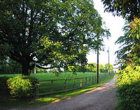
Wirswall is a village and civil parish in the unitary authority of Cheshire East
and the ceremonial county of Cheshire
, England
, located at SJ544441 near the Shropshire
border, around 1½ miles north of Whitchurch
. The historical township had an area of 973 acres (3.9 km²). The civil parish also includes the settlements of Bradeley Green
, Wicksted and part of Willey Moor.
According to the 2001 Census
, the parish had a population of 76.
Period.
The village appears in the Domesday Book
as Wiresuelle, an outlying estate of Marbury. Like much of the land in the Nantwich
hundred it was then held by William Malbank, having been earlier held by Earl Harold. The Domesday Book describes it as being 'waste', suggesting that any settlement might have been destroyed during the suppression of the rebellion of 1069–70. In 1288, it formed part of the barony of Wich Malbank. In 1656, Wirswall (then spelled Wyrsal) was held by the Hinton family.
The population was formerly 103 (1801), 83 (1851), 138 (1901) and 169 (1951).
at 156 m is located to the south east of the village at SJ549438. Nearby villages include Marbury and Wrenbury
.
The South Cheshire Way
(long-distance footpath) runs through the village, and Bishop Bennet Way
(bridleway) terminates there. The Llangollen branch of the Shropshire Union Canal
runs ¾ miles to its east.
lived in Wirswall between 1861 and 1867, while working at the Whitchurch branch of the Whitchurch & Ellesmere Bank, and many of his illustrations feature local landscapes.
Cheshire East
Cheshire East is a unitary authority area with borough status in the ceremonial county of Cheshire, England.The borough was established in April 2009 as part of the 2009 structural changes to local government in England, by virtue of an order under the Local Government and Public Involvement in...
and the ceremonial county of Cheshire
Cheshire
Cheshire is a ceremonial county in North West England. Cheshire's county town is the city of Chester, although its largest town is Warrington. Other major towns include Widnes, Congleton, Crewe, Ellesmere Port, Runcorn, Macclesfield, Winsford, Northwich, and Wilmslow...
, England
England
England is a country that is part of the United Kingdom. It shares land borders with Scotland to the north and Wales to the west; the Irish Sea is to the north west, the Celtic Sea to the south west, with the North Sea to the east and the English Channel to the south separating it from continental...
, located at SJ544441 near the Shropshire
Shropshire
Shropshire is a county in the West Midlands region of England. For Eurostat purposes, the county is a NUTS 3 region and is one of four counties or unitary districts that comprise the "Shropshire and Staffordshire" NUTS 2 region. It borders Wales to the west...
border, around 1½ miles north of Whitchurch
Whitchurch, Shropshire
Whitchurch is a market town in Shropshire, England on the border between England and Wales. It is the oldest continuously inhabited town in Shropshire. According to the 2001 Census, the population of the town is 8,673, with a more recent estimate putting the population of the town at 8,934...
. The historical township had an area of 973 acres (3.9 km²). The civil parish also includes the settlements of Bradeley Green
Bradeley Green
Bradeley Green is a village in Shropshire, England....
, Wicksted and part of Willey Moor.
According to the 2001 Census
United Kingdom Census 2001
A nationwide census, known as Census 2001, was conducted in the United Kingdom on Sunday, 29 April 2001. This was the 20th UK Census and recorded a resident population of 58,789,194....
, the parish had a population of 76.
History
A large perforated stone axe was found in the village, suggesting occupation during the NeolithicNeolithic
The Neolithic Age, Era, or Period, or New Stone Age, was a period in the development of human technology, beginning about 9500 BC in some parts of the Middle East, and later in other parts of the world. It is traditionally considered as the last part of the Stone Age...
Period.
The village appears in the Domesday Book
Domesday Book
Domesday Book , now held at The National Archives, Kew, Richmond upon Thames in South West London, is the record of the great survey of much of England and parts of Wales completed in 1086...
as Wiresuelle, an outlying estate of Marbury. Like much of the land in the Nantwich
Nantwich
Nantwich is a market town and civil parish in the Borough of Cheshire East and the ceremonial county of Cheshire, England. The town gives its name to the parliamentary constituency of Crewe and Nantwich...
hundred it was then held by William Malbank, having been earlier held by Earl Harold. The Domesday Book describes it as being 'waste', suggesting that any settlement might have been destroyed during the suppression of the rebellion of 1069–70. In 1288, it formed part of the barony of Wich Malbank. In 1656, Wirswall (then spelled Wyrsal) was held by the Hinton family.
The population was formerly 103 (1801), 83 (1851), 138 (1901) and 169 (1951).
Geography and transport
The village is surrounded by low hills, which form the highest land in the immediate area. A trig pointTrig point
A triangulation station, also known as a triangulation pillar, trigonometrical station, trigonometrical point, trig station, trig beacon or trig point, and sometimes informally as a trig, is a fixed surveying station, used in geodetic surveying and other surveying projects in its vicinity...
at 156 m is located to the south east of the village at SJ549438. Nearby villages include Marbury and Wrenbury
Wrenbury
Wrenbury is a village in the civil parish of Wrenbury cum Frith, the unitary authority of Cheshire East, and the ceremonial county of Cheshire, England...
.
The South Cheshire Way
South Cheshire Way
The South Cheshire Way is a long-distance footpath running east–west mainly through Cheshire, England, though parts lie in Shropshire and Staffordshire. The western section from Grindley Brook, near Whitchurch, runs through farmland; the eastern section from Mow Cop, near Biddulph, runs through...
(long-distance footpath) runs through the village, and Bishop Bennet Way
Bishop Bennet Way
The Bishop Bennet Way is a route for horse riding in south west Cheshire, England, which can also be used by walkers and cyclists. It is named after William Bennet , Bishop of Cork and Ross and subsequently Bishop of Cloyne , who carried out detailed surveys of roman roads including those...
(bridleway) terminates there. The Llangollen branch of the Shropshire Union Canal
Shropshire Union Canal
The Shropshire Union Canal is a navigable canal in England; the Llangollen and Montgomery canals are the modern names of branches of the Shropshire Union system and lie partially in Wales....
runs ¾ miles to its east.
Landmarks
Wicksted Hall is a brick and timbered building with a stone portal, dating from the late 19th century. Wirswall Hall has a grade-II-listed timber-framed barn dating from the 16th or 17th centuries. There are also two grade-II-listed farmhouses. Grange Farm has a two-storey, four-bay farmhouse with a projecting gabled bay. The building is dated 1636 and has a timber frame with brick infill. Wood Farm has a two-storey Gothic-style farmhouse in rendered brick which dates from the early 19th century. The slightly projecting central bay of the main building bears a shield and is flanked with two octagonal turrets capped with pinnacles.Notable people
The Victorian children's book illustrator Randolph CaldecottRandolph Caldecott
Randolph Caldecott was a British artist and illustrator, born in Chester. The Caldecott Medal was named in his honor. He exercised his art chiefly in book illustrations. His abilities as an artist were promptly and generously recognized by the Royal Academy. Caldecott greatly influenced...
lived in Wirswall between 1861 and 1867, while working at the Whitchurch branch of the Whitchurch & Ellesmere Bank, and many of his illustrations feature local landscapes.