

Buerton, Crewe and Nantwich
Encyclopedia

Cheshire East
Cheshire East is a unitary authority area with borough status in the ceremonial county of Cheshire, England.The borough was established in April 2009 as part of the 2009 structural changes to local government in England, by virtue of an order under the Local Government and Public Involvement in...
and the ceremonial county of Cheshire
Cheshire
Cheshire is a ceremonial county in North West England. Cheshire's county town is the city of Chester, although its largest town is Warrington. Other major towns include Widnes, Congleton, Crewe, Ellesmere Port, Runcorn, Macclesfield, Winsford, Northwich, and Wilmslow...
, England, about 7 miles south of the town of Nantwich
Nantwich
Nantwich is a market town and civil parish in the Borough of Cheshire East and the ceremonial county of Cheshire, England. The town gives its name to the parliamentary constituency of Crewe and Nantwich...
and 1½ miles east of the village of Audlem
Audlem
Audlem is a large village and civil parish located in the unitary authority of Cheshire East and the ceremonial county of Cheshire in the north west of England, approximately south of Nantwich. Close to the border with the neighbouring county of Shropshire, the village is eight miles east of...
, on the border with Shropshire
Shropshire
Shropshire is a county in the West Midlands region of England. For Eurostat purposes, the county is a NUTS 3 region and is one of four counties or unitary districts that comprise the "Shropshire and Staffordshire" NUTS 2 region. It borders Wales to the west...
. The parish also includes the small settlements of Hankins Heys, Moblake, Pinder's End and Three Wells, as well as parts of Chapel End, College Fields, Kinsey Heath, Longhill, Raven's Bank, Sandyford and Woolfall. In 2001, the total population was a little under 500. Nearby villages include Adderley
Adderley
Adderley is a village and civil parish in the English county of Shropshire, several kilometres north of Market Drayton. It is known as Eldredelei in the Domesday Book...
, Audlem, Bridgemere
Bridgemere
Bridgemere is a village and civil parish in the unitary authority of Cheshire East and the ceremonial county of Cheshire, England. It is around south east of Nantwich and west of Stoke-on-Trent. The southern boundary of the parish is on the border with Shropshire...
, Hankelow
Hankelow
Hankelow is a village and civil parish in the unitary authority of Cheshire East and the ceremonial county of Cheshire, England. It used to be a township within the township of Audlem, one mile away on the Nantwich Road. According to the 2001 Census, the parish had a population of 272.Hankelow is...
, Hatherton
Hatherton, Cheshire
Hatherton is a hamlet and civil parish in the unitary authority of Cheshire East and the ceremonial county of Cheshire, England. The hamlet is located 2¾ miles to the north east of Audlem and 3¾ miles to the south east of Nantwich. The parish also includes the small settlements of Birchall Moss,...
, Hunsterson
Hunsterson
Hunsterson is a hamlet and civil parish in the unitary authority of Cheshire East and the ceremonial county of Cheshire, England. The hamlet is located 2¾ miles to the north east of Audlem and 6 miles to the south of Crewe. The parish also includes the settlements of Brown Moss, Four Lane End,...
and Woore
Woore
Woore is a village and civil parish in the north of the English county of Shropshire. It had a population of 1,411 in the 2001 census. The name means "boundary" in ancient celtic and this fits nicely with the fact that it is on the boundary with both the counties of Cheshire and Staffordshire.The...
.
History
Buerton appears in the Domesday surveyDomesday Book
Domesday Book , now held at The National Archives, Kew, Richmond upon Thames in South West London, is the record of the great survey of much of England and parts of Wales completed in 1086...
as Burtune; it was then held by William Malbank, who held much of the land in the Nantwich hundred, and had a hawk's eyrie. In 1804, it formed part of the estate of the Earl of Grosvenor
Duke of Westminster
The title Duke of Westminster was created by Queen Victoria in 1874 and bestowed upon Hugh Grosvenor, 3rd Marquess of Westminster. The current holder of the title is Gerald Grosvenor, 6th Duke of Westminster....
. The village had a windmill in 1653; the surviving building just outside Buerton village dates from 1779 and was in use until 1880. A school was founded in Buerton village in 1871 by the British and Foreign School Society
British and Foreign School Society
The British and Foreign School Society offers charitable aid to educational projects in the UK and around the world by funding schools, other charities and educational bodies...
, and a Band of Hope
Hope UK
Hope UK is a national Christian charity located at 25 Copperfield Street, London, England which educates children and young people about drug and alcohol abuse.-Band of Hope:...
lecture hall was built in 1885.
Governance
Buerton is administered by the Buerton Parish Council. From 1974 the civil parish was served by Crewe and NantwichCrewe and Nantwich
Crewe and Nantwich was, from 1974 to 2009, a local government district with borough status in Cheshire, England. It had a population of 111,007...
Borough Council, which was succeeded on 1 April 2009 by the new unitary authority
Unitary authority
A unitary authority is a type of local authority that has a single tier and is responsible for all local government functions within its area or performs additional functions which elsewhere in the relevant country are usually performed by national government or a higher level of sub-national...
of Cheshire East
Cheshire East
Cheshire East is a unitary authority area with borough status in the ceremonial county of Cheshire, England.The borough was established in April 2009 as part of the 2009 structural changes to local government in England, by virtue of an order under the Local Government and Public Involvement in...
. Buerton falls in the parliamentary constituency of Eddisbury
Eddisbury (UK Parliament constituency)
Eddisbury is a county constituency represented in the House of Commons of the Parliament of the United Kingdom. It elects one Member of Parliament by the first-past-the-post system of election.- Boundaries :...
, and has been represented by Stephen O'Brien since 1999.
Geography, transport and economy
Shropshire
Shropshire is a county in the West Midlands region of England. For Eurostat purposes, the county is a NUTS 3 region and is one of four counties or unitary districts that comprise the "Shropshire and Staffordshire" NUTS 2 region. It borders Wales to the west...
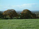
border, south of College Fields. The area is predominantly rural, with the major land use being agricultural. Cheese remains a product of the parish. Several small areas of woodland are located within the civil parish, including Brick-kiln Wood, Brook Plantation, Fox Covert, Long Wood and The Ox Leasow. Birchall Brook forms part of the north-eastern parish boundary; several unnamed brooks run through the parish and there are many scattered small meres and ponds.
The A525
A525 road
The A525 is major route from Rhyl in North Wales to Newcastle-under-Lyme in England. On the way, it passes near to Denbigh, through Ruthin, through Wrexham and near Whitchurch.It is dual carriageway just south of Rhyl...
(Woore Road) runs east–west through the parish from Audlem
Audlem
Audlem is a large village and civil parish located in the unitary authority of Cheshire East and the ceremonial county of Cheshire in the north west of England, approximately south of Nantwich. Close to the border with the neighbouring county of Shropshire, the village is eight miles east of...
to Woore
Woore
Woore is a village and civil parish in the north of the English county of Shropshire. It had a population of 1,411 in the 2001 census. The name means "boundary" in ancient celtic and this fits nicely with the fact that it is on the boundary with both the counties of Cheshire and Staffordshire.The...
in Shropshire. On or near the western boundary of the parish, Kettle Lane runs southwards from the A525 through Kinsey Heath, connecting with Paddock Lane and Bagley Lane within the parish of Audlem, while Longhill Lane runs northwards from the A525 through Moblake, Raven's Bank, Longhill and Woolfall towards Hankelow
Hankelow
Hankelow is a village and civil parish in the unitary authority of Cheshire East and the ceremonial county of Cheshire, England. It used to be a township within the township of Audlem, one mile away on the Nantwich Road. According to the 2001 Census, the parish had a population of 272.Hankelow is...
. Buerton village is centred on the junction of the A525 and Windmill Lane, which runs north-westwards to meet Longhill Lane at Longhill. Woodhouse Lane continues Kettle Lane, running broadly east–west through the south of the parish, becoming Bellaport Road in Shropshire. The National Cycle Network
National Cycle Network
The National Cycle Network is a network of cycle routes in the United Kingdom.The National Cycle Network was created by the charity Sustrans , and aided by a £42.5 million National Lottery grant. In 2005 it was used for over 230 million trips.Many routes hope to minimise contact with motor...
Regional Route 75 runs southwards from Audlem along the western parish boundary and then cuts broadly eastwards through the south of the parish, following Kettle and Woodhouse Lanes.
Demography
In 2006, the total population of the civil parish was estimated as 480. The 2001 census recorded a population of 492, in 189 households. The historical population figures were 405 (1801), 444 (1851), 408 (1901) and 405 (1951).Places of worship
A United Free Gospel Chapel in Buerton village dates from 1885. A former Wesleyan Methodist Chapel, also in Buerton village, dates from 1891; it closed in 1975.Other landmarks
Timber framing
Timber framing , or half-timbering, also called in North America "post-and-beam" construction, is the method of creating structures using heavy squared off and carefully fitted and joined timbers with joints secured by large wooden pegs . It is commonplace in large barns...
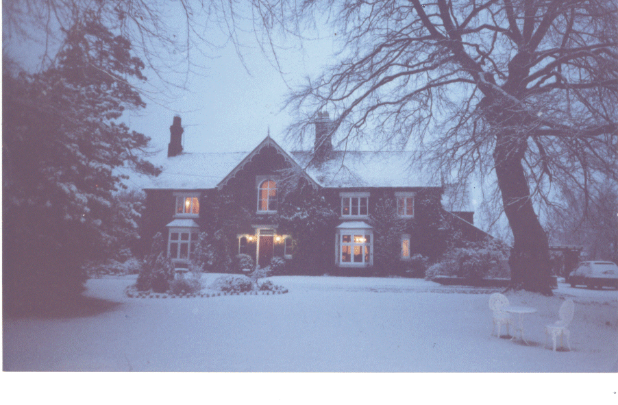
country house of Highfields
Highfields, Buerton
Highfields, Buerton is a small country house in the civil parish of Buerton, Cheshire, England. It has been designated by English Heritage as a Grade I listed building....
at dates from 1615 and was built for the Dodds family; it is listed at grade I. Woodhouse Farmhouse is a grade-II*-listed, red-brick farmhouse on Woodhouse Lane, dating from the late 17th or early 18th century; the garden wall and gatepiers of the farmhouse are also listed at grade II. Smithy House and Dairy House, both on Woore Road, are timber-framed former farmhouses with brick infill, dating originally from the 17th century with 19th century additions; both are listed at grade II. Buerton Old House in Buerton village dates from the 17th century. Buerton House was originally Tythe Barn Farm, and its Edwardian brickwork conceals a much older core. Kynsal Lodge, off Kettle Lane, is a red-brick country house dating from around 1850. Its stables block is of the same date; both are listed at grade II.
.jpg)
Hope UK
Hope UK is a national Christian charity located at 25 Copperfield Street, London, England which educates children and young people about drug and alcohol abuse.-Band of Hope:...
lecture hall. A war memorial is located on the front of the former school. Several farm buildings are listed at grade II. There are two timber-framed barns with brick infill; that at Woodhouse Farm dates from the 16th or 17th century, while that at Dairy House dates from the 17th century. An early 19th century red-brick farm building at Malt Kiln Farm on Woore Road is also listed.
Education
Buerton Primary School in Buerton village closed in 2006. The parish falls within the catchment areas of Audlem St James CE Primary School in AudlemAudlem
Audlem is a large village and civil parish located in the unitary authority of Cheshire East and the ceremonial county of Cheshire in the north west of England, approximately south of Nantwich. Close to the border with the neighbouring county of Shropshire, the village is eight miles east of...
and Brine Leas High School
Brine Leas High School
Brine Leas School is a comprehensive academy in Nantwich, Cheshire, UK. The school has 1287 students enrolled, and has Technologyand Language, status....
in Nantwich
Nantwich
Nantwich is a market town and civil parish in the Borough of Cheshire East and the ceremonial county of Cheshire, England. The town gives its name to the parliamentary constituency of Crewe and Nantwich...
.