

Bickerton, Cheshire
Encyclopedia
Cheshire East
Cheshire East is a unitary authority area with borough status in the ceremonial county of Cheshire, England.The borough was established in April 2009 as part of the 2009 structural changes to local government in England, by virtue of an order under the Local Government and Public Involvement in...
and the ceremonial county of Cheshire
Cheshire
Cheshire is a ceremonial county in North West England. Cheshire's county town is the city of Chester, although its largest town is Warrington. Other major towns include Widnes, Congleton, Crewe, Ellesmere Port, Runcorn, Macclesfield, Winsford, Northwich, and Wilmslow...
, England
England
England is a country that is part of the United Kingdom. It shares land borders with Scotland to the north and Wales to the west; the Irish Sea is to the north west, the Celtic Sea to the south west, with the North Sea to the east and the English Channel to the south separating it from continental...
, about eight miles (13 km) north of Whitchurch
Whitchurch, Shropshire
Whitchurch is a market town in Shropshire, England on the border between England and Wales. It is the oldest continuously inhabited town in Shropshire. According to the 2001 Census, the population of the town is 8,673, with a more recent estimate putting the population of the town at 8,934...
in Shropshire
Shropshire
Shropshire is a county in the West Midlands region of England. For Eurostat purposes, the county is a NUTS 3 region and is one of four counties or unitary districts that comprise the "Shropshire and Staffordshire" NUTS 2 region. It borders Wales to the west...
. The parish also includes the small settlement of Gallantry Bank, with a total population of over 200. The two Bickerton Hill
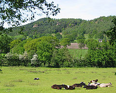
Bickerton Hill
Bickerton Hill refers to two low red sandstone hills that form the southern end of the Mid Cheshire Ridge in Cheshire, north-west England. The high point, Raw Head, lies on the northerly hill and has an elevation of 227 metres...
s also lie partly within the civil parish.
History
Bickerton appears in the Domesday surveyDomesday Book
Domesday Book , now held at The National Archives, Kew, Richmond upon Thames in South West London, is the record of the great survey of much of England and parts of Wales completed in 1086...
as Bicretone. It was owned by Drogo from Robert FitzHugh, baron of Malpas, and was found waste at the time of the survey. Woodland extending to half a league (about ¾ mile) was recorded. The name is Anglo-Saxon in origin, and relates to bees.
Geography

Bickerton Hill
Bickerton Hill refers to two low red sandstone hills that form the southern end of the Mid Cheshire Ridge in Cheshire, north-west England. The high point, Raw Head, lies on the northerly hill and has an elevation of 227 metres...
s falls within the civil parish, although the parts of the hills are in the Duckington
Duckington
Duckington is a small village and civil parish in the unitary authority of Cheshire West and Chester and the ceremonial county of Cheshire, England.-External links:...
, Larkton
Larkton
Larkton is a civil parish in the Borough of Cheshire West and Chester and ceremonial county of Cheshire in England. It has a population of 28.-External links:...
and Harthill
Harthill, Cheshire
Harthill is a village and civil parish in the unitary authority of Cheshire West and Chester and the ceremonial county of Cheshire, England.All Saints Church, Harthill is a Grade II* listed building.-External links:...
parishes. Raw Head lies north of the A534, while the southerly hill (212 m) lies south of the road, immediately northwest of Bickerton village. The area around Raw Head and much of the southerly hill are designated Sites of Special Scientific Interest
Site of Special Scientific Interest
A Site of Special Scientific Interest is a conservation designation denoting a protected area in the United Kingdom. SSSIs are the basic building block of site-based nature conservation legislation and most other legal nature/geological conservation designations in Great Britain are based upon...
. A wider area covering much of the north and west of the civil parish is also designated an Area of Special County Value. Around 300 acres (1.2 km²) of the southerly hill are managed by the National Trust
National Trust for Places of Historic Interest or Natural Beauty
The National Trust for Places of Historic Interest or Natural Beauty, usually known as the National Trust, is a conservation organisation in England, Wales and Northern Ireland...
.
Demography
Places of worship
The Church of the Holy TrinityHoly Trinity Church, Bickerton
Holy Trinity Church, Bickerton stands to the north of the village of Bickerton, Cheshire, England. The church has been designated by English Heritage as a Grade II listed building. It is an active Anglican parish church in the diocese of Chester, the archdeaconry of Chester, and the deanery...
in Bickerton village dates from 1839, and became a parish church in 1869. Built of red sandstone, with Edmund Sharpe
Edmund Sharpe
Edmund Sharpe was an English architect and engineer. He started his career as an architect, initially on his own, then in partnership with Edward Paley, designing mainly churches but also some secular buildings...
as the architect, it is listed at grade II. A war memorial
War memorial
A war memorial is a building, monument, statue or other edifice to celebrate a war or victory, or to commemorate those who died or were injured in war.-Historic usage:...
stands in the adjacent graveyard, overlooking the crossroads of Goldford Lane and Long Lane.
Other landmarks
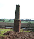
Copper
Copper is a chemical element with the symbol Cu and atomic number 29. It is a ductile metal with very high thermal and electrical conductivity. Pure copper is soft and malleable; an exposed surface has a reddish-orange tarnish...
mine chimney in red sandstone is located near Gallantry Bank, adjacent to the A534. Dating from the early 19th century, it is a rare remnant of the copper mining industry in this area. The copper mine was owned by the Egerton family of Oulton, and is thought to have been operational in 1697.
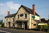
The Bickerton Poacher public house stands on the A534 by the junction with Stone House Lane.
Transport
The A534 runs east–west through the parish. Other major through routes include Long Lane running south from the A534 towards MalpasMalpas, Cheshire
Malpas is a large village which used to be a market town, and it is also a civil parish in the unitary authority of Cheshire West and Chester and the ceremonial county of Cheshire, England. The parish lies on the border with Shropshire and Wales...
, and a lane running southeast from Long Lane to Cholmondeley
Cholmondeley, Cheshire
Cholmondeley is a civil parish in the unitary authority of Cheshire East and the ceremonial county of Cheshire, England, which lies to the north east of Malpas and to the west of Nantwich. It includes the small settlements of Croxton Green and Dowse Green , with a total population of a little...
which connects with the A49
A49 road
The A49 is a major road in western England, which traverses the Welsh Marches region. It runs north from Ross-on-Wye in Herefordshire via Hereford, Leominster, Ludlow, Shrewsbury and Whitchurch, then continues through central Cheshire to Warrington and Wigan before terminating at its junction with...
. The Sandstone Trail
Sandstone Trail
The Sandstone Trail is a long-distance walkers' path, following sandstone ridges running north–south from Frodsham in central Cheshire to Whitchurch just over the Shropshire border. The path was created in 1974 and extended in the 1990s...
runs east from the summit of the southerly Bickerton Hill, crosses the A534, runs northwest to the summit of Raw Head and then turns south east to climb Bulkeley Hill
Bulkeley
Bulkeley is a village and civil parish in the unitary authority of Cheshire East and the ceremonial county of Cheshire, England. The village is situated at on the A534 about 9 miles west of Nantwich. The civil parish also includes the small settlement of Bulkelehay at , with a total population...
.
Education
Bickerton Holy Trinity CE Primary School stands on Long Lane. It serves Bickerton as well as the nearby civil parishes of BulkeleyBulkeley
Bulkeley is a village and civil parish in the unitary authority of Cheshire East and the ceremonial county of Cheshire, England. The village is situated at on the A534 about 9 miles west of Nantwich. The civil parish also includes the small settlement of Bulkelehay at , with a total population...
, Cholmondeley
Cholmondeley, Cheshire
Cholmondeley is a civil parish in the unitary authority of Cheshire East and the ceremonial county of Cheshire, England, which lies to the north east of Malpas and to the west of Nantwich. It includes the small settlements of Croxton Green and Dowse Green , with a total population of a little...
, Chorley
Chorley, Crewe and Nantwich
Chorley is a hamlet and civil parish in the unitary authority of Cheshire East and the ceremonial county of Cheshire, England. The hamlet lies 5 miles to the west of Nantwich and 6 miles to the north east of Malpas. Nearby villages include Faddiley, Norbury, Ravensmoor and Wrenbury...
, Egerton
Egerton, Cheshire
Egerton is a civil parish in the unitary authority of Cheshire East and the ceremonial county of Cheshire, England. A largely rural area, the parish includes the small settlement of Egerton Green , which lies 3¾ miles to the north east of Malpas and 8 miles to the west of Nantwich, as well as Fairy...
, Ridley
Ridley, Cheshire
Ridley is a civil parish in the unitary authority of Cheshire East and the ceremonial county of Cheshire, England, which lies to the north east of Malpas and to the west of Nantwich. The parish is largely rural with scattered farms and buildings and no significant settlements. In 2001, the...
and part of Duckington
Duckington
Duckington is a small village and civil parish in the unitary authority of Cheshire West and Chester and the ceremonial county of Cheshire, England.-External links:...
.
Bickerton civil parish falls within the catchment area of Bishop Heber High School
Bishop Heber High School
Bishop Heber High School is a comprehensive secondary school and specialist languages college in Malpas, Cheshire. The school itself is named after Reginald Heber who was an English bishop born in Malpas, Cheshire and is now remembered chiefly as a hymn-writer.-Notable alumni:*Ben Foden, Rugby...
in Malpas
Malpas, Cheshire
Malpas is a large village which used to be a market town, and it is also a civil parish in the unitary authority of Cheshire West and Chester and the ceremonial county of Cheshire, England. The parish lies on the border with Shropshire and Wales...
.