

Coole Pilate
Encyclopedia
Cheshire East
Cheshire East is a unitary authority area with borough status in the ceremonial county of Cheshire, England.The borough was established in April 2009 as part of the 2009 structural changes to local government in England, by virtue of an order under the Local Government and Public Involvement in...
and the ceremonial county of Cheshire
Cheshire
Cheshire is a ceremonial county in North West England. Cheshire's county town is the city of Chester, although its largest town is Warrington. Other major towns include Widnes, Congleton, Crewe, Ellesmere Port, Runcorn, Macclesfield, Winsford, Northwich, and Wilmslow...
, England
England
England is a country that is part of the United Kingdom. It shares land borders with Scotland to the north and Wales to the west; the Irish Sea is to the north west, the Celtic Sea to the south west, with the North Sea to the east and the English Channel to the south separating it from continental...
, which lies to the north of Audlem
Audlem
Audlem is a large village and civil parish located in the unitary authority of Cheshire East and the ceremonial county of Cheshire in the north west of England, approximately south of Nantwich. Close to the border with the neighbouring county of Shropshire, the village is eight miles east of...
and to the south of Nantwich
Nantwich
Nantwich is a market town and civil parish in the Borough of Cheshire East and the ceremonial county of Cheshire, England. The town gives its name to the parliamentary constituency of Crewe and Nantwich...
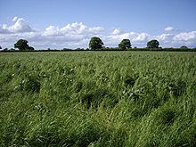
. The area is predominantly rural with scattered farms, and a total population of 60 people. Nearby villages include Broomhall Green
Broomhall Green
Broomhall Green or Broomhall is a village and civil parish in the unitary authority of Cheshire East and the ceremonial county of Cheshire, England. It includes part of the settlement of Sandford. According to the 2001 Census the parish had a population of 206. The village is about 3½ miles...
, Hankelow
Hankelow
Hankelow is a village and civil parish in the unitary authority of Cheshire East and the ceremonial county of Cheshire, England. It used to be a township within the township of Audlem, one mile away on the Nantwich Road. According to the 2001 Census, the parish had a population of 272.Hankelow is...
, Hatherton
Hatherton, Cheshire
Hatherton is a hamlet and civil parish in the unitary authority of Cheshire East and the ceremonial county of Cheshire, England. The hamlet is located 2¾ miles to the north east of Audlem and 3¾ miles to the south east of Nantwich. The parish also includes the small settlements of Birchall Moss,...
and Newhall
Newhall, Cheshire
Newhall is a village and civil parish in the unitary authority of Cheshire East and the ceremonial county of Cheshire, England. The village lies 3½ miles to the west of Audlem and 5 miles to the south west of Nantwich...
.
History
Croft (land)
A croft is a fenced or enclosed area of land, usually small and arable with a crofter's dwelling thereon. A crofter is one who has tenure and use of the land, typically as a tenant farmer.- Etymology :...
growing pill oats. A brine
Brine
Brine is water, saturated or nearly saturated with salt .Brine is used to preserve vegetables, fruit, fish, and meat, in a process known as brining . Brine is also commonly used to age Halloumi and Feta cheeses, or for pickling foodstuffs, as a means of preserving them...
spring is shown on an 1831 map of the area, and is presumably the source of local place names such as "Brine Pit".
Little is known of the early history of the area. A square perforated stone hoe believed to date from the Bronze Age
Bronze Age
The Bronze Age is a period characterized by the use of copper and its alloy bronze as the chief hard materials in the manufacture of some implements and weapons. Chronologically, it stands between the Stone Age and Iron Age...
was found in a field to the west of Old Hall in 1936, suggesting possible settlement during that period. Coole Pilate is not mentioned by name in the Domesday survey
Domesday Book
Domesday Book , now held at The National Archives, Kew, Richmond upon Thames in South West London, is the record of the great survey of much of England and parts of Wales completed in 1086...
. Most of the area of the modern civil parish fell within the ancient parish
Ancient parishes of Cheshire
The Ancient Parishes of Cheshire refers to the group of parishes that existed in Cheshire, roughly within the period of 1200–1800. Initially, the ancient parishes had only an ecclesiastical function, but reforms initiated by King Henry VIII, developed by Queen Elizabeth I and expanded by...
of Acton
Acton, Cheshire (ancient parish)
Acton was an ancient parish in the Nantwich Hundred of Cheshire, England.At one time it included the townships of Acton, Aston juxta Mondrum, Austerson, Baddington, Brindley, Burland, Cholmondeston, Edleston, Faddiley, Henhull, Hurleston, Poole, Stoke, Worleston, most of Coole Pilate, parts of...
in the Nantwich Hundred
Hundreds of Cheshire
The Hundreds of Cheshire, as with other Hundreds in England were the geographic divisions of Cheshire for administrative, military and judicial purposes. They were introduced in Cheshire some time before the Norman conquest...
; it was served by St Mary's Church, Acton
St Mary's Church, Acton
St Mary's Church, Acton is an active Anglican church in Acton, a village to the west of Nantwich, Cheshire, England. It has been designated by English Heritage as a Grade I listed building. A church has been present on this site since before the time of the Domesday Survey. The tower is the...
. A loom
Loom
A loom is a device used to weave cloth. The basic purpose of any loom is to hold the warp threads under tension to facilitate the interweaving of the weft threads...
weight was found in the area, suggesting that weaving
Weaving
Weaving is a method of fabric production in which two distinct sets of yarns or threads are interlaced at right angles to form a fabric or cloth. The other methods are knitting, lace making and felting. The longitudinal threads are called the warp and the lateral threads are the weft or filling...
was carried out locally around the 16th century. There is evidence of a local brickworks
Brickworks
A brickworks also known as a brick factory, is a factory for the manufacturing of bricks, from clay or shale. Usually a brickworks is located on a clay bedrock often with a quarry for clay on site....
and pottery
Pottery
Pottery is the material from which the potteryware is made, of which major types include earthenware, stoneware and porcelain. The place where such wares are made is also called a pottery . Pottery also refers to the art or craft of the potter or the manufacture of pottery...
around the 18th–19th centuries.
In around 1836, landowners in the parish included the Earl of Kilmorey
Earl of Kilmorey
Earl of Kilmorey is a title in the Peerage of Ireland. It was created in 1822 for Francis Needham, 12th Viscount Kilmorey, a General in the British Army and former Member of Parliament for Newry. He was made Viscount Newry and Mourne, in the County of Down, at the same time, also in the Peerage of...
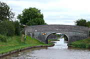
, a major landowner locally, as well as Charles Wicksted, Richard Johnson and the Reverend Jeremiah Smith. The Birmingham and Liverpool Junction Canal
Birmingham and Liverpool Junction Canal
The Birmingham and Liverpool Junction Canal was a canal in England which ran from Nantwich, where it joined the Chester Canal, to Autherley, where it joined the Staffordshire and Worcestershire Canal...
, now part of the Shropshire Union
Shropshire Union Canal
The Shropshire Union Canal is a navigable canal in England; the Llangollen and Montgomery canals are the modern names of branches of the Shropshire Union system and lie partially in Wales....
, was completed in 1835. The Nantwich and Market Drayton Railway, constructed in 1863, ran north–south through the parish; a halt at Coole Pilate was opened in 1935. The halt closed in 1963 and the line was subsequently dismantled, although the supports of the former railway bridge over the Shropshire Union Canal
Shropshire Union Canal
The Shropshire Union Canal is a navigable canal in England; the Llangollen and Montgomery canals are the modern names of branches of the Shropshire Union system and lie partially in Wales....
still remain near Austin's Bridge.
The parish had a platoon in the Home Guard during the Second World War
World War II
World War II, or the Second World War , was a global conflict lasting from 1939 to 1945, involving most of the world's nations—including all of the great powers—eventually forming two opposing military alliances: the Allies and the Axis...
, which guarded the canal bridges and reinforced the RAF
Royal Air Force
The Royal Air Force is the aerial warfare service branch of the British Armed Forces. Formed on 1 April 1918, it is the oldest independent air force in the world...
at the nearby Hack Green Radar Station
Hack Green Secret Nuclear Bunker
The Hack Green Secret Nuclear Bunker is a former government-owned nuclear bunker located at Hack Green, Cheshire, England.- History :The first military use of the area was in World War II, when a Starfish site was established at Hack Green...
.
Governance
Coole Pilate has been administered since 1950 by Sound and District Parish Council. From 1974 the civil parish was served by Crewe and NantwichCrewe and Nantwich
Crewe and Nantwich was, from 1974 to 2009, a local government district with borough status in Cheshire, England. It had a population of 111,007...
Borough Council, which was succeeded on 1 April 2009 by the new unitary authority
Unitary authority
A unitary authority is a type of local authority that has a single tier and is responsible for all local government functions within its area or performs additional functions which elsewhere in the relevant country are usually performed by national government or a higher level of sub-national...
of Cheshire East
Cheshire East
Cheshire East is a unitary authority area with borough status in the ceremonial county of Cheshire, England.The borough was established in April 2009 as part of the 2009 structural changes to local government in England, by virtue of an order under the Local Government and Public Involvement in...
. Coole Pilate falls in the parliamentary constituency of Crewe and Nantwich
Crewe and Nantwich (UK Parliament constituency)
Crewe and Nantwich is a county constituency represented in the House of Commons of the Parliament of the United Kingdom. It elects one Member of Parliament by the first-past-the-post system of election. For 25 years since its creation in 1983, the constituency had elected the Labour MP Gwyneth...
, which has been represented by Edward Timpson
Edward Timpson
Anthony Edward Timpson is a British Conservative Party politician. He became a Member of Parliament in 2008 after winning a by-election in the constituency of Crewe and Nantwich.-Biography:Timpson was born in Knutsford, Cheshire, in 1973...
since a by-election in 2008.
Geography, transport and economy
Shropshire Union Canal
The Shropshire Union Canal is a navigable canal in England; the Llangollen and Montgomery canals are the modern names of branches of the Shropshire Union system and lie partially in Wales....
runs north–south through the parish; it is crossed by the Cool Lane roadbridge and the Austin's and Hall's footbridges. The River Weaver
River Weaver
The River Weaver is a river, navigable in its lower reaches, running in a curving route anti-clockwise across west Cheshire, northern England. Improvements to the river to make it navigable were authorised in 1720 and the work, which included eleven locks, was completed in 1732...
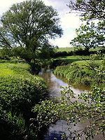
runs along the eastern border, and Finnaker brook runs north–south in the west of the parish. Several small meres and ponds are scattered across the farmland, and there are also a few small areas of woodland.
Coole Lane, which connects Nantwich
Nantwich
Nantwich is a market town and civil parish in the Borough of Cheshire East and the ceremonial county of Cheshire, England. The town gives its name to the parliamentary constituency of Crewe and Nantwich...
with the A525
A525 road
The A525 is major route from Rhyl in North Wales to Newcastle-under-Lyme in England. On the way, it passes near to Denbigh, through Ruthin, through Wrexham and near Whitchurch.It is dual carriageway just south of Rhyl...
near Audlem
Audlem
Audlem is a large village and civil parish located in the unitary authority of Cheshire East and the ceremonial county of Cheshire in the north west of England, approximately south of Nantwich. Close to the border with the neighbouring county of Shropshire, the village is eight miles east of...
, runs north–south through the parish and is the major road. Brine Pits Lane runs from Coole Lane to Brinepits Farm. The A529
A529 road
The A529 is a non-primary road in England that runs from the A41 at Hinstock in Shropshire to the A530 in Nantwich, Cheshire. ....
lies to the east of the parish. The South Cheshire Way
South Cheshire Way
The South Cheshire Way is a long-distance footpath running east–west mainly through Cheshire, England, though parts lie in Shropshire and Staffordshire. The western section from Grindley Brook, near Whitchurch, runs through farmland; the eastern section from Mow Cop, near Biddulph, runs through...
long-distance footpath runs east–west through the parish.
Demography
In 2006, the total population of the civil parish was estimated as 50. The 2001 census recorded a population of 60. Historical population figures were 39 (1801), 43 (1851), 53 (1901) and 70 (1951).Landmarks
Coole Pilate Chapel on Coole Lane at was built in 1850 by the Wesleyan Methodist Association. Other landmarks include the large farms of Old Hall at the junction of Coole Lane and Brine Pits Lane , and Brinepits at the end of Brine Pits Lane .Education
There are no educational facilities within the civil parish. Coole Pilate falls within the catchment areas of Sound and District Primary School in SoundSound, Cheshire
Sound is a hamlet and civil parish in the unitary authority of Cheshire East and the ceremonial county of Cheshire, England. The hamlet is located 3¼ miles to the south west of Nantwich. The parish also includes the small settlements of Newtown and Sound Heath...
and Brine Leas High School
Brine Leas High School
Brine Leas School is a comprehensive academy in Nantwich, Cheshire, UK. The school has 1287 students enrolled, and has Technologyand Language, status....
in Nantwich
Nantwich
Nantwich is a market town and civil parish in the Borough of Cheshire East and the ceremonial county of Cheshire, England. The town gives its name to the parliamentary constituency of Crewe and Nantwich...
.
Notable residents
Isabella WhitneyIsabella Whitney
Isabella Whitney is the earliest identified woman to have published secular poetry in the English language. She has been called "the first professional woman poet in England."-Biography:...
, the first woman known to have published secular poetry in the English language, is thought to have been born at Coole Pilate.
Source
- Latham FA, ed. Acton, p. 9, (The Local History Group; 1995) (ISBN 0-9522284-1-6)