

Baddington
Encyclopedia

Cheshire East
Cheshire East is a unitary authority area with borough status in the ceremonial county of Cheshire, England.The borough was established in April 2009 as part of the 2009 structural changes to local government in England, by virtue of an order under the Local Government and Public Involvement in...
and the ceremonial county of Cheshire
Cheshire
Cheshire is a ceremonial county in North West England. Cheshire's county town is the city of Chester, although its largest town is Warrington. Other major towns include Widnes, Congleton, Crewe, Ellesmere Port, Runcorn, Macclesfield, Winsford, Northwich, and Wilmslow...
, England
England
England is a country that is part of the United Kingdom. It shares land borders with Scotland to the north and Wales to the west; the Irish Sea is to the north west, the Celtic Sea to the south west, with the North Sea to the east and the English Channel to the south separating it from continental...
, which lies immediately to the south west of Nantwich
Nantwich
Nantwich is a market town and civil parish in the Borough of Cheshire East and the ceremonial county of Cheshire, England. The town gives its name to the parliamentary constituency of Crewe and Nantwich...
and north of Audlem
Audlem
Audlem is a large village and civil parish located in the unitary authority of Cheshire East and the ceremonial county of Cheshire in the north west of England, approximately south of Nantwich. Close to the border with the neighbouring county of Shropshire, the village is eight miles east of...
. Predominantly rural with scattered farms, the civil parish has a total population of around 100 people and includes the dispersed settlement of Hack Green, the site of a former RAF
Royal Air Force
The Royal Air Force is the aerial warfare service branch of the British Armed Forces. Formed on 1 April 1918, it is the oldest independent air force in the world...
base and Home Defence regional headquarters. Nearby villages include Aston
Aston by Wrenbury
Aston is a village in the civil parish of Newhall in the unitary authority of Cheshire East and the ceremonial county of Cheshire, England.The village should not be confused with several other villages named Aston in Cheshire, which include Aston...
, Broomhall Green
Broomhall Green
Broomhall Green or Broomhall is a village and civil parish in the unitary authority of Cheshire East and the ceremonial county of Cheshire, England. It includes part of the settlement of Sandford. According to the 2001 Census the parish had a population of 206. The village is about 3½ miles...
, Hankelow
Hankelow
Hankelow is a village and civil parish in the unitary authority of Cheshire East and the ceremonial county of Cheshire, England. It used to be a township within the township of Audlem, one mile away on the Nantwich Road. According to the 2001 Census, the parish had a population of 272.Hankelow is...
, Ravensmoor
Ravensmoor
Ravensmoor is a village in the unitary authority of Cheshire East and the ceremonial county of Cheshire, England, located at . It is split between the civil parishes of Baddiley and Burland...
, Sound Heath
Sound, Cheshire
Sound is a hamlet and civil parish in the unitary authority of Cheshire East and the ceremonial county of Cheshire, England. The hamlet is located 3¼ miles to the south west of Nantwich. The parish also includes the small settlements of Newtown and Sound Heath...
and Stapeley
Stapeley
Stapeley is a hamlet and civil parish in the unitary authority of Cheshire East and the ceremonial county of Cheshire, England. The hamlet lies 2¼ miles to the south east of Nantwich...
.
History
The name Baddington is of Saxon origin, and means "Beada's Farm". It is not mentioned by name in the Domesday surveyDomesday Book
Domesday Book , now held at The National Archives, Kew, Richmond upon Thames in South West London, is the record of the great survey of much of England and parts of Wales completed in 1086...
, the first record being in the period 1175–84. The civil parish fell within the ancient parish
Ancient parishes of Cheshire
The Ancient Parishes of Cheshire refers to the group of parishes that existed in Cheshire, roughly within the period of 1200–1800. Initially, the ancient parishes had only an ecclesiastical function, but reforms initiated by King Henry VIII, developed by Queen Elizabeth I and expanded by...
of Acton
Acton, Cheshire (ancient parish)
Acton was an ancient parish in the Nantwich Hundred of Cheshire, England.At one time it included the townships of Acton, Aston juxta Mondrum, Austerson, Baddington, Brindley, Burland, Cholmondeston, Edleston, Faddiley, Henhull, Hurleston, Poole, Stoke, Worleston, most of Coole Pilate, parts of...
in the Nantwich Hundred
Hundreds of Cheshire
The Hundreds of Cheshire, as with other Hundreds in England were the geographic divisions of Cheshire for administrative, military and judicial purposes. They were introduced in Cheshire some time before the Norman conquest...
; it was served by St Mary's Church, Acton
St Mary's Church, Acton
St Mary's Church, Acton is an active Anglican church in Acton, a village to the west of Nantwich, Cheshire, England. It has been designated by English Heritage as a Grade I listed building. A church has been present on this site since before the time of the Domesday Survey. The tower is the...
. In reign of Edward III
Edward III of England
Edward III was King of England from 1327 until his death and is noted for his military success. Restoring royal authority after the disastrous reign of his father, Edward II, Edward III went on to transform the Kingdom of England into one of the most formidable military powers in Europe...
(1327–77), the land was acquired by the Bromley family, who had their seat at Baddington Hall. A famous member of that family was Sir John Bromley, who served in the wars in France
Hundred Years' War
The Hundred Years' War was a series of separate wars waged from 1337 to 1453 by the House of Valois and the House of Plantagenet, also known as the House of Anjou, for the French throne, which had become vacant upon the extinction of the senior Capetian line of French kings...
and, according to Hall's History of Nantwich, "heroically recovered the British Standard at Corbie" in 1415, just before the Battle of Agincourt
Battle of Agincourt
The Battle of Agincourt was a major English victory against a numerically superior French army in the Hundred Years' War. The battle occurred on Friday, 25 October 1415 , near modern-day Azincourt, in northern France...
. He was buried at Acton
St Mary's Church, Acton
St Mary's Church, Acton is an active Anglican church in Acton, a village to the west of Nantwich, Cheshire, England. It has been designated by English Heritage as a Grade I listed building. A church has been present on this site since before the time of the Domesday Survey. The tower is the...
in 1419. In the 16th century, the Fouleshurst family were also landowners in the parish. Later the land passed to the Lords Kilmorley
Earl of Kilmorey
Earl of Kilmorey is a title in the Peerage of Ireland. It was created in 1822 for Francis Needham, 12th Viscount Kilmorey, a General in the British Army and former Member of Parliament for Newry. He was made Viscount Newry and Mourne, in the County of Down, at the same time, also in the Peerage of...
, the owner in 1800, who was a major landowner in this part of Cheshire. A gazetteer entry of 1870–2 mentions twenty houses, with a total property value of £1,715. In 1936, a small area of the civil parish was transferred to Nantwich
Nantwich
Nantwich is a market town and civil parish in the Borough of Cheshire East and the ceremonial county of Cheshire, England. The town gives its name to the parliamentary constituency of Crewe and Nantwich...
.
Part of Baddington and the adjacent parish of Austerson was forest until at least the mid-17th century, with wood being used as fuel for salt production in nearby Nantwich
Nantwich
Nantwich is a market town and civil parish in the Borough of Cheshire East and the ceremonial county of Cheshire, England. The town gives its name to the parliamentary constituency of Crewe and Nantwich...
. Salt might also have been produced within the parish, as a brine
Brine
Brine is water, saturated or nearly saturated with salt .Brine is used to preserve vegetables, fruit, fish, and meat, in a process known as brining . Brine is also commonly used to age Halloumi and Feta cheeses, or for pickling foodstuffs, as a means of preserving them...
spring is shown on an 1831 map of the area. The parish formerly had a small water-powered mill and a brick kiln field. Agriculture was the major land use by the early 19th century.
The road between Nantwich and Edleston
Edleston
Edleston is a civil parish in the unitary authority of Cheshire East and the ceremonial county of Cheshire, England, which lies immediately to the south west of Nantwich. For administrative purposes, it is combined with adjacent civil parishes of Acton and Henhull to form a total area of 765 hectares...
crossed the parish; in 1607, the right of way was 12 feet wide. Transport connections improved in the 19th century with the construction first of the Birmingham and Liverpool Junction Canal
Birmingham and Liverpool Junction Canal
The Birmingham and Liverpool Junction Canal was a canal in England which ran from Nantwich, where it joined the Chester Canal, to Autherley, where it joined the Staffordshire and Worcestershire Canal...
, now part of the Shropshire Union
Shropshire Union Canal
The Shropshire Union Canal is a navigable canal in England; the Llangollen and Montgomery canals are the modern names of branches of the Shropshire Union system and lie partially in Wales....
(1835), and then the now-dismantled Nantwich and Market Drayton Railway (1863).
Governance
Since 1950, Baddington has been administered by Sound and District Parish Council. From 1974 the civil parish was served by Crewe and NantwichCrewe and Nantwich
Crewe and Nantwich was, from 1974 to 2009, a local government district with borough status in Cheshire, England. It had a population of 111,007...
Borough Council, which was succeeded on 1 April 2009 by the new unitary authority
Unitary authority
A unitary authority is a type of local authority that has a single tier and is responsible for all local government functions within its area or performs additional functions which elsewhere in the relevant country are usually performed by national government or a higher level of sub-national...
of Cheshire East
Cheshire East
Cheshire East is a unitary authority area with borough status in the ceremonial county of Cheshire, England.The borough was established in April 2009 as part of the 2009 structural changes to local government in England, by virtue of an order under the Local Government and Public Involvement in...
. Baddington falls in the parliamentary constituency of Eddisbury
Eddisbury (UK Parliament constituency)
Eddisbury is a county constituency represented in the House of Commons of the Parliament of the United Kingdom. It elects one Member of Parliament by the first-past-the-post system of election.- Boundaries :...
, and has been represented by Stephen O'Brien since 1999.
Geography and transport
Shropshire Union Canal
The Shropshire Union Canal is a navigable canal in England; the Llangollen and Montgomery canals are the modern names of branches of the Shropshire Union system and lie partially in Wales....
runs broadly north–south through the parish. The Baddington section of the canal contains the two Hackgreen Locks as well as two cast-iron canal mile posts; all date from around 1826 and are listed at grade II. It is also crossed by two road bridges, Baddington Lane Bridge (A530) and Burrow's Bridge (French Lane), as well as Hack Green footbridge; all three canal bridges are listed at grade II.
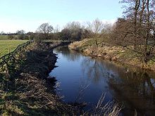
A short stretch of the River Weaver
River Weaver
The River Weaver is a river, navigable in its lower reaches, running in a curving route anti-clockwise across west Cheshire, northern England. Improvements to the river to make it navigable were authorised in 1720 and the work, which included eleven locks, was completed in 1732...
near Nantwich Lake runs through the northern tip of the parish, and Shrew Bridge (A530) lies on the parish boundary. Several small meres and ponds are scattered across the farmland. There are two small woods, Broomhall Gorse and Gorse Covert, which lie to the west of the canal, as well as other smaller areas of unnamed woodland.

A530 road
The A530 road is a road linking the A525 east of Whitchurch, Shropshire, England with the A559 east of Northwich, in Cheshire. The road follows the route:*A525*Nantwich*Crewe*Middlewich*A559...
(known successively as Whitchurch Road, Baddington Lane and Shrewbridge Road) runs through the parish from the south west to the north east. Coole Lane runs north–south, joining the A530 at the north of the parish; French Lane/French Lane End runs east–west. The Welsh Marches Railway
Welsh Marches Line
The Welsh Marches Line , known historically as the North and West Route, is the railway line running from Newport in south-east Wales to Shrewsbury in the West Midlands region of England by way of Abergavenny, Hereford and Craven Arms, and thence to Crewe via Whitchurch...
runs immediately to the north west of the parish, being less than 50 metres beyond the boundary at the closest point. The Crewe and Nantwich Circular Walk
Crewe and Nantwich Circular Walk
The Crewe and Nantwich Circular Walk is a long-distance walkers' path in the Cheshire East area of Cheshire, England. As the name suggests, the walk forms a circuit around the towns of Crewe and Nantwich...
crosses the northern tip of the parish.
Demography
In 2006, the total population of the civil parish was estimated as 100. The 2001 census recorded a population of 98, in 38 households. Historical population figures were 121 (1801), 155 (1851), 123 (1901) and 132 (1951).Hack Green
World War II
World War II, or the Second World War , was a global conflict lasting from 1939 to 1945, involving most of the world's nations—including all of the great powers—eventually forming two opposing military alliances: the Allies and the Axis...
, Hack Green was at first used as a decoy for Crewe railway junction
Crewe railway station
Crewe railway station was completed in 1837 and is one of the most historic railway stations in the world. Built in fields near to Crewe Hall, it originally served the village of Crewe with a population of just 70 residents...
. In 1941, an RAF
Royal Air Force
The Royal Air Force is the aerial warfare service branch of the British Armed Forces. Formed on 1 April 1918, it is the oldest independent air force in the world...
camp was established there, with a fixed ground-controlled intercept radar
Radar
Radar is an object-detection system which uses radio waves to determine the range, altitude, direction, or speed of objects. It can be used to detect aircraft, ships, spacecraft, guided missiles, motor vehicles, weather formations, and terrain. The radar dish or antenna transmits pulses of radio...
station, one of a network of twenty-one across the country. After the war, the site was equipped with a partially underground bunker
Bunker
A military bunker is a hardened shelter, often buried partly or fully underground, designed to protect the inhabitants from falling bombs or other attacks...
protecting an air-defence radar installation, part of the ROTOR
ROTOR
ROTOR was a huge and elaborate air defence radar system built by the British Government in the early 1950s to counter possible attack by Soviet bombers...
network. Between 1958 and 1966, Hack Green served as a joint civil and military air traffic control
Air traffic control
Air traffic control is a service provided by ground-based controllers who direct aircraft on the ground and in the air. The primary purpose of ATC systems worldwide is to separate aircraft to prevent collisions, to organize and expedite the flow of traffic, and to provide information and other...
site. In 1976–84, the abandoned RAF site was converted into a nuclear bunker complex, which was the Home Defence regional headquarters for a large area of the North West until 1993.
The site, now known as "Hack Green Secret Nuclear Bunker
Hack Green Secret Nuclear Bunker
The Hack Green Secret Nuclear Bunker is a former government-owned nuclear bunker located at Hack Green, Cheshire, England.- History :The first military use of the area was in World War II, when a Starfish site was established at Hack Green...
" , became a museum in 1998. In addition to the Hack Green installations, the museum houses Ballistic Missile Early Warning System
Ballistic Missile Early Warning System
The United States Air Force Ballistic Missile Early Warning System was the first operational ballistic missile detection radar. The original system was built in 1959 and could provide long-range warning of a ballistic missile attack over the polar region of the Northern Hemisphere. They also...
equipment from RAF High Wycombe
RAF High Wycombe
RAF High Wycombe is a Royal Air Force station, situated in the village of Walters Ash, near High Wycombe in Buckinghamshire, England. Its purpose is to serve the needs of the RAF Air Command, situated on the site. It is also the headquarters of the European Air Group...
, as well as decommissioned nuclear weapon
Nuclear weapon
A nuclear weapon is an explosive device that derives its destructive force from nuclear reactions, either fission or a combination of fission and fusion. Both reactions release vast quantities of energy from relatively small amounts of matter. The first fission bomb test released the same amount...
s from various sites.
Other landmarks
Hack House on French Lane is a timber-framedTimber framing
Timber framing , or half-timbering, also called in North America "post-and-beam" construction, is the method of creating structures using heavy squared off and carefully fitted and joined timbers with joints secured by large wooden pegs . It is commonplace in large barns...
farmhouse with brick infill, featuring small framing. Dating originally from the early 17th century, it is listed at grade II*. Also on French Lane is the grade-II-listed Hack House Farm House , a roughcast brick farmhouse dating originally from the early 17th century. Baddington Bank Farm on Baddington Lane is an L-shaped red-brick farmhouse dating from the late 17th century, and is also listed at grade II. Other landmarks within the civil parish include a dry moated site.
Education
There are no educational facilities within the civil parish. Baddington falls within the catchment areas of Sound and District Primary School in SoundSound, Cheshire
Sound is a hamlet and civil parish in the unitary authority of Cheshire East and the ceremonial county of Cheshire, England. The hamlet is located 3¼ miles to the south west of Nantwich. The parish also includes the small settlements of Newtown and Sound Heath...
and Brine Leas High School
Brine Leas High School
Brine Leas School is a comprehensive academy in Nantwich, Cheshire, UK. The school has 1287 students enrolled, and has Technologyand Language, status....
in Nantwich
Nantwich
Nantwich is a market town and civil parish in the Borough of Cheshire East and the ceremonial county of Cheshire, England. The town gives its name to the parliamentary constituency of Crewe and Nantwich...
.