

Burland
Encyclopedia
Cheshire East
Cheshire East is a unitary authority area with borough status in the ceremonial county of Cheshire, England.The borough was established in April 2009 as part of the 2009 structural changes to local government in England, by virtue of an order under the Local Government and Public Involvement in...
and the ceremonial county of Cheshire
Cheshire
Cheshire is a ceremonial county in North West England. Cheshire's county town is the city of Chester, although its largest town is Warrington. Other major towns include Widnes, Congleton, Crewe, Ellesmere Port, Runcorn, Macclesfield, Winsford, Northwich, and Wilmslow...
, England
England
England is a country that is part of the United Kingdom. It shares land borders with Scotland to the north and Wales to the west; the Irish Sea is to the north west, the Celtic Sea to the south west, with the North Sea to the east and the English Channel to the south separating it from continental...
, about 2½ miles west of Nantwich
Nantwich
Nantwich is a market town and civil parish in the Borough of Cheshire East and the ceremonial county of Cheshire, England. The town gives its name to the parliamentary constituency of Crewe and Nantwich...
. The civil parish also includes the small settlements of Burland Lower Green, Burland Upper Green, Hollin Green and Stoneley Green, as well as parts of Gradeley Green and Swanley. The eastern part of the village of Ravensmoor
Ravensmoor
Ravensmoor is a village in the unitary authority of Cheshire East and the ceremonial county of Cheshire, England, located at . It is split between the civil parishes of Baddiley and Burland...
also falls within the civil parish (also in the parish of Baddiley
Baddiley
Baddiley is a scattered settlement and civil parish in the unitary authority of Cheshire East and the ceremonial county of Cheshire, England. The civil parish also includes the north-western part of the village of Ravensmoor , as well as the small settlements of Baddiley Hulse, Batterley Hill, and...
).
According to the 2001 census the civil parish had a total population of 582.
History
The civil parish formerly had populations of 371 (1801), 627 (1851), 581 (1901) and 546 (1951).Geography and transport
Wrexham
Wrexham is a town in Wales. It is the administrative centre of the wider Wrexham County Borough, and the largest town in North Wales, located in the east of the region. It is situated between the Welsh mountains and the lower Dee Valley close to the border with Cheshire, England...
crosses the civil parish east–west.
The Llangollen branch
Llangollen Canal
The Llangollen Canal is a navigable canal crossing the border between England and Wales. The waterway links Llangollen in Denbighshire, north Wales, with Hurleston in south Cheshire, via the town of Ellesmere, Shropshire....
of the Shropshire Union Canal
Shropshire Union Canal
The Shropshire Union Canal is a navigable canal in England; the Llangollen and Montgomery canals are the modern names of branches of the Shropshire Union system and lie partially in Wales....
, just south of Hurleston Junction
Hurleston Junction
Hurleston Junction is the name of the canal junction where the Llangollen Canal terminates and meets the Shropshire Union Canal main line at Hurleston, Cheshire, England....
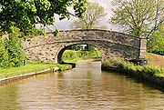
, runs north–south through the civil parish, immediately to the east of Burland village. The canal is crossed by Wrexham Bridge (carrying the A534) and the grade-II-listed Swanley Bridge, which dates from around 1793, as well as three footbridges: Bethills Bridge, Stoneley Green Bridge and Platt's Bridge. North of Swanley Bridge lies Swanley Lock No. 2; the grade-II-listed lock dates from 1805 and is in blue-and-red brick with stone copings.
Several small conifer plantations fall within the civil parish, including Admiral's Plantation and Tally-ho Covert to the north of Ravensmoor, and Long Plantation near Swanley.
Places of worship
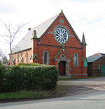
The Baddiley and Ravensmoor Methodist Church, formerly a Wesleyan Chapel, stands on Swanley Lane in RavensmoorRavensmoor
Ravensmoor is a village in the unitary authority of Cheshire East and the ceremonial county of Cheshire, England, located at . It is split between the civil parishes of Baddiley and Burland...
(at SJ 620 507). Dated 1878, the building is in orange brick with stone dressing and has a prominent circular window and pillars capped with decorative stonework.
A Primitive Methodist Chapel dating from 1833 was located in the civil parish; it closed in 1965.
Parish Council
Burland is under Burland Parish Council. The council consists of 9 councillors, which meet monthly. In 2011 the Parish Council launched their own website: Burland Parish Council WebsiteOther notable buildings
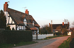
The civil parish also contains several grade-II-listed black-and-white cottages dating from the 17th century, some of which retain thatched roofs. These include Hollybank Cottage in Barracks Lane, Pear Tree Farmhouse and Rose & End Cottages in Stoneley Green, and Sparrows Roost in Swanley Lane.
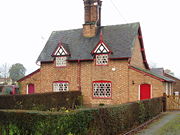
Wrexham Road in Burland village is lined by several grade-II-listed buildings dating from around 1870, formerly cottages of the Peckforton Estates. The red-brick cottages feature hexagonal latticed windows, ornate timber gabling and a prominent central chimney stack. Burland Farm House, also built for the Peckforton Estate, is of a similar date.
Ravensmoor Windmill, a former windmill dating from the early 19th century, has been restored as a residential property.
Burland also has its own shop called Burland Stores.