

Palliser Bay
Encyclopedia
North Island
The North Island is one of the two main islands of New Zealand, separated from the much less populous South Island by Cook Strait. The island is in area, making it the world's 14th-largest island...
of New Zealand
New Zealand
New Zealand is an island country in the south-western Pacific Ocean comprising two main landmasses and numerous smaller islands. The country is situated some east of Australia across the Tasman Sea, and roughly south of the Pacific island nations of New Caledonia, Fiji, and Tonga...
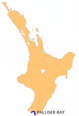
, to the southeast of Wellington. It runs for 40 kilometres along the Cook Strait
Cook Strait
Cook Strait is the strait between the North and South Islands of New Zealand. It connects the Tasman Sea on the west with the South Pacific Ocean on the east....
coast from Turakirae Head
Turakirae Head
Turakirae Head is a promontory on the southern coast of New Zealand's North Island. It is located at the western end of Palliser Bay, 20 kilometres southeast of Wellington, at the southern end of the Rimutaka Ranges. The head is an excellent example of tectonic uplift within the Wellington region...
at the southern end of the Rimutaka Ranges to Cape Palliser
Cape Palliser
Cape Palliser is a promontory on the southern coast of New Zealand's North Island and the southernmost point of the North Island - it is in fact considerably further south than Nelson or Blenheim in the South Island....
, the North Island's southernmost point.
Inland from the bay is the plain of the Ruamahanga River
Ruamahanga River
The Ruamahanga River runs through the southeastern North Island of New Zealand.The river's headwaters are in the Tararua Ranges northwest of Masterton. From there it runs firstly south and then southwest for 130 kilometers before emptying into the Cook Strait. The towns of Masterton and...
, which has its outflow in the bay. This river flows into and also drains Lake Wairarapa
Lake Wairarapa
Lake Wairarapa is a lake at the southern end of the North Island of New Zealand, 50 kilometers east of Wellington. The lake covers an area of 78 km², and is the third largest in the North Island, fractionally smaller than Lake Rotorua...
, the shores of which are only 10 kilometres from the coast.
There are several notable geographical features in the area, including the Pūtangirua Pinnacles
Putangirua Pinnacles
The Putangirua Pinnacles -also known colloquially simply as The Pinnacles- as a geological formation are one of New Zealand's best examples of "badlands erosion" and consist of a large number of earth pillars or Hoodoos located at the head of a valley in the Aorangi Ranges...
, Kupe's Sail
Kupe's Sail
Kupe's Sail is a geological formation near the eastern end of Palliser Bay at the southern end of the North Island of New Zealand.It is composed of sedimentary rock which has been thrust up in an earthquake, resulting in a characteristic flat triangular ridge having the appearance of the kind of...
and the Whatarangi Bluff - where erosion has had dramatic effects on the coastline.

External links
- Te Ara - article on the Palliser Bay area