

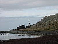
Cape Campbell
Encyclopedia
Maori language
Māori or te reo Māori , commonly te reo , is the language of the indigenous population of New Zealand, the Māori. It has the status of an official language in New Zealand...
, is located in Marlborough, New Zealand
Marlborough, New Zealand
Marlborough is one of the regions of New Zealand, located in the northeast of the South Island. Marlborough is a unitary authority, both a region and a district, and its council is located at Blenheim. Marlborough is known for its dry climate, the picturesque Marlborough Sounds, and sauvignon blanc...
, on the northeastern coast of the South Island
South Island
The South Island is the larger of the two major islands of New Zealand, the other being the more populous North Island. It is bordered to the north by Cook Strait, to the west by the Tasman Sea, to the south and east by the Pacific Ocean...
. It lies at the southern end of Clifford Bay
Clifford Bay, New Zealand
Clifford Bay is a bay in the northeast of the South Island of New Zealand, in the Marlborough Region. It lies between Cloudy Bay to the northwest, and Cape Campbell, the easternmost point of the South Island...
, 15 km northeast of Ward
Ward, New Zealand
Ward is a small town in Marlborough, New Zealand. It is located on State Highway 1, 20 kilometres south of Seddon. Kaikoura is 82 km to the southwest...
, and 42 km southeast of Blenheim
Blenheim, New Zealand
Blenheim is the most populous town in the region of Marlborough, in the north east of the South Island of New Zealand, and the seat of the regional council. It has a population of The area which surrounds the town is well known as a centre of New Zealand's wine industry...
.
It is the third easternmost point of the south island, at a longitude of about 174o16.5' East.
The two easternmost points are West head
West Head
West Head is the name of three separate headlands on New Zealand's South Island., at the entrance to Okains Bay on Banks Peninsula., at the end of a peninsula on the northern shore of Queen Charlotte Sound., a rocky headland at the entrance to Tory Channel....
(it is the western shore of the opening to Tory Channel
Tory Channel
Tory Channel is one of the drowned valleys that form the Marlborough Sounds in New Zealand.Tory Channel is named after the "Tory", a pioneer ship that brought British colonists to Wellington in 1840. It lies to the south of Arapawa Island, separating it from the mainland. At its western end it...
- the opposing shore being on Arapawa Island
Arapawa Island
Arapawa Island is a small island located in the Marlborough Sounds, at the north east tip of the South Island of New Zealand.The island has a land area of...
), and Cape Jackson (between the entrances to Queen Charlotte Sound and Port Gore), both at a longitude of 174o19' east.
Cape Campbell lies close to the salt
Salt
In chemistry, salts are ionic compounds that result from the neutralization reaction of an acid and a base. They are composed of cations and anions so that the product is electrically neutral...
works at Lake Grassmere.
External links
- Cape Campbell at Land Information New Zealand.