
Coastline of the North Sea
Encyclopedia
The coastline of the North Sea has been evolving since the last glacier receded. The coastline varies from fjords, river estuaries to mudflats.  The eastern and western coasts of the North Sea
are jagged, as they were stripped by glacier
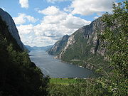
s during the ice ages. The coastlines along the southernmost part are soft, covered with the remains of deposited glacial sediment, which was left directly by the ice or has been redeposited by the sea. The Norwegian mountains plunge into the sea, giving birth, north of Stavanger
, to deep fjord
s and archipelago
s. South of Stavanger, the coast softens, the islands become fewer. The eastern Scottish coast is similar, though less severe than Norway. Starting from Flamborough Head in the north east of England, the cliffs become lower and are composed of less resistant moraine
, which erodes more easily, so that the coasts have more rounded contours. In Holland, Belgium and in the east of England (East Anglia
) the littoral
is low and marshy. The east coast and south-east of the North Sea (Wadden Sea
) have coastlines that are mainly sandy and straight owing to longshore currents, particularly along Belgium and Denmark.
 The northern North Sea coasts bear the impression of the enormous glaciers which covered them during the Ice Age
s and created fjords, lakes and valleys along the coastline and landscape. Fjord
s arose by the action of glaciers, which dragged their way through them from the highlands, cutting and scraping deep trenches in the land. Fjords are particularly common on the coast of Norway.
Firth
s are similar to fjords, but are generally shallower with broader bays in which small islands may be found. The glaciers that formed them influenced the land over a wider area and scraped away larger areas. Firths are to be found mostly on the Scottish and northern English coasts. Individual islands in the firths, or islands and the coast, are often joined up by sandbars or spits made up of sand deposits known as "tombolo
s".
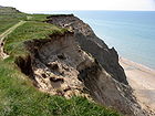 Towards the south the firths give way to a cliff coast, which was formed by the moraine
s of Ice Age glaciers. The horizontal impact of waves on the North Sea coast gives rise to eroded coasts. The cliff landscape is interrupted in southern England by large estuaries
with their corresponding fringing marshes, notably the Humber and the Thames.
There are skerries
in southern Norway formed by similar action to that which created the fjords and firths. The glaciers in these places affected the land to an even greater extent, so that large areas were scraped away. The coastal brim (Strandflaten), which is found especially in southern Norway, is a gently sloping lowland area between the sea and the mountains. It consists of plates of rock platforms, and often extends for kilometres, reaching under the sea, at a depth of only a few metres.
 The Wadden Sea
stretches between Esbjerg
, Denmark in the north and Den Helder
, Netherlands in the west. This landscape is heavily influenced by the tides and important sections of it have been declared a National Park. The whole of the coastal zone is shallow; the tides flood large areas and uncover them again, constantly depositing sediments. The Southern Bight has been especially changed by land reclamation, as the Dutch have been especially active. The largest project of this type was the diking and reclamation of the IJsselmeer
.
Tidal forces have formed the Frisian Islands
. In the micro tidal area, (a tidal range
of up to 1.35 metres (4.4 ft), such as on the Dutch or Danish coasts,
barrier beaches with dune
s are formed. In the mesotidal area (a tidal range of between 1.35 and 2.9 m (4.4-9.5 ft), barrier island
s are formed; in the macrotidal area (above 2.9 metres (9.5 ft) tidal range), intertidal deposits raise the spring tide range 4 metres (13.1 ft). A soft rock coast is formed in the meso-macro tidal areas located in the southern North Sea. These soft rock coastal bedrock plains are interspersed with soft rock (shale and sandstone) cliffs.
The small, historically strategic island of Heligoland
was not formed by sediment deposition; it is considerably older and is composed of early Triassic
sandstone
.
North Sea
In the southwest, beyond the Straits of Dover, the North Sea becomes the English Channel connecting to the Atlantic Ocean. In the east, it connects to the Baltic Sea via the Skagerrak and Kattegat, narrow straits that separate Denmark from Norway and Sweden respectively...
are jagged, as they were stripped by glacier
Glacier
A glacier is a large persistent body of ice that forms where the accumulation of snow exceeds its ablation over many years, often centuries. At least 0.1 km² in area and 50 m thick, but often much larger, a glacier slowly deforms and flows due to stresses induced by its weight...
s during the ice ages. The coastlines along the southernmost part are soft, covered with the remains of deposited glacial sediment, which was left directly by the ice or has been redeposited by the sea. The Norwegian mountains plunge into the sea, giving birth, north of Stavanger
Stavanger
Stavanger is a city and municipality in the county of Rogaland, Norway.Stavanger municipality has a population of 126,469. There are 197,852 people living in the Stavanger conurbation, making Stavanger the fourth largest city, but the third largest urban area, in Norway...
, to deep fjord
Fjord
Geologically, a fjord is a long, narrow inlet with steep sides or cliffs, created in a valley carved by glacial activity.-Formation:A fjord is formed when a glacier cuts a U-shaped valley by abrasion of the surrounding bedrock. Glacial melting is accompanied by rebound of Earth's crust as the ice...
s and archipelago
Archipelago
An archipelago , sometimes called an island group, is a chain or cluster of islands. The word archipelago is derived from the Greek ἄρχι- – arkhi- and πέλαγος – pélagos through the Italian arcipelago...
s. South of Stavanger, the coast softens, the islands become fewer. The eastern Scottish coast is similar, though less severe than Norway. Starting from Flamborough Head in the north east of England, the cliffs become lower and are composed of less resistant moraine
Moraine
A moraine is any glacially formed accumulation of unconsolidated glacial debris which can occur in currently glaciated and formerly glaciated regions, such as those areas acted upon by a past glacial maximum. This debris may have been plucked off a valley floor as a glacier advanced or it may have...
, which erodes more easily, so that the coasts have more rounded contours. In Holland, Belgium and in the east of England (East Anglia
East Anglia
East Anglia is a traditional name for a region of eastern England, named after an ancient Anglo-Saxon kingdom, the Kingdom of the East Angles. The Angles took their name from their homeland Angeln, in northern Germany. East Anglia initially consisted of Norfolk and Suffolk, but upon the marriage of...
) the littoral
Littoral
The littoral zone is that part of a sea, lake or river that is close to the shore. In coastal environments the littoral zone extends from the high water mark, which is rarely inundated, to shoreline areas that are permanently submerged. It always includes this intertidal zone and is often used to...
is low and marshy. The east coast and south-east of the North Sea (Wadden Sea
Wadden Sea
The Wadden Sea is an intertidal zone in the southeastern part of the North Sea. It lies between the coast of northwestern continental Europe and the range of Frisian Islands, forming a shallow body of water with tidal flats and wetlands. It is rich in biological diversity...
) have coastlines that are mainly sandy and straight owing to longshore currents, particularly along Belgium and Denmark.
Northern fjords, skerries, and cliffs
Ice age
An ice age or, more precisely, glacial age, is a generic geological period of long-term reduction in the temperature of the Earth's surface and atmosphere, resulting in the presence or expansion of continental ice sheets, polar ice sheets and alpine glaciers...
s and created fjords, lakes and valleys along the coastline and landscape. Fjord
Fjord
Geologically, a fjord is a long, narrow inlet with steep sides or cliffs, created in a valley carved by glacial activity.-Formation:A fjord is formed when a glacier cuts a U-shaped valley by abrasion of the surrounding bedrock. Glacial melting is accompanied by rebound of Earth's crust as the ice...
s arose by the action of glaciers, which dragged their way through them from the highlands, cutting and scraping deep trenches in the land. Fjords are particularly common on the coast of Norway.
Firth
Firth
Firth is the word in the Lowland Scots language and in English used to denote various coastal waters in Scotland and England. In mainland Scotland it is used to describe a large sea bay, or even a strait. In the Northern Isles it more usually refers to a smaller inlet...
s are similar to fjords, but are generally shallower with broader bays in which small islands may be found. The glaciers that formed them influenced the land over a wider area and scraped away larger areas. Firths are to be found mostly on the Scottish and northern English coasts. Individual islands in the firths, or islands and the coast, are often joined up by sandbars or spits made up of sand deposits known as "tombolo
Tombolo
A tombolo, from the Italian tombolo, derived from the Latin tumulus, meaning 'mound,' and sometimes translated as ayre , is a deposition landform in which an island is attached to the mainland by a narrow piece of land such as a spit or bar. Once attached, the island is then known as a tied island...
s".
Moraine
A moraine is any glacially formed accumulation of unconsolidated glacial debris which can occur in currently glaciated and formerly glaciated regions, such as those areas acted upon by a past glacial maximum. This debris may have been plucked off a valley floor as a glacier advanced or it may have...
s of Ice Age glaciers. The horizontal impact of waves on the North Sea coast gives rise to eroded coasts. The cliff landscape is interrupted in southern England by large estuaries
Estuary
An estuary is a partly enclosed coastal body of water with one or more rivers or streams flowing into it, and with a free connection to the open sea....
with their corresponding fringing marshes, notably the Humber and the Thames.
There are skerries
Skerry
A skerry is a small rocky island, usually defined to be too small for habitation. It may simply be a rocky reef. A skerry can also be called a low sea stack....
in southern Norway formed by similar action to that which created the fjords and firths. The glaciers in these places affected the land to an even greater extent, so that large areas were scraped away. The coastal brim (Strandflaten), which is found especially in southern Norway, is a gently sloping lowland area between the sea and the mountains. It consists of plates of rock platforms, and often extends for kilometres, reaching under the sea, at a depth of only a few metres.
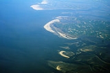
Southern shoals and mudflats
The shallow-water coasts of the southern and eastern coast up to Denmark were formed by ice age activity, but their particular shape is determined for the most part by the sea and sediment deposits.Wadden Sea
The Wadden Sea is an intertidal zone in the southeastern part of the North Sea. It lies between the coast of northwestern continental Europe and the range of Frisian Islands, forming a shallow body of water with tidal flats and wetlands. It is rich in biological diversity...
stretches between Esbjerg
Esbjerg
Esbjerg Municipality is a municipality in Region of Southern Denmark on the west coast of the Jutland peninsula in southwest Denmark. Its mayor is Johnny Søtrup, from the Venstre political party...
, Denmark in the north and Den Helder
Den Helder
Den Helder is a municipality and a city in the Netherlands, in the province of North Holland. Den Helder occupies the northernmost point of the North Holland peninsula...
, Netherlands in the west. This landscape is heavily influenced by the tides and important sections of it have been declared a National Park. The whole of the coastal zone is shallow; the tides flood large areas and uncover them again, constantly depositing sediments. The Southern Bight has been especially changed by land reclamation, as the Dutch have been especially active. The largest project of this type was the diking and reclamation of the IJsselmeer
IJsselmeer
IJsselmeer is a shallow artificial lake of 1100 km² in the central Netherlands bordering the provinces of Flevoland, North Holland and Friesland, with an average depth of 5 to 6 m. The IJsselmeer is the largest lake in Western Europe....
.
Tidal forces have formed the Frisian Islands
Frisian Islands
The Frisian Islands, also known as the Wadden Islands or Wadden Sea Islands, form an archipelago at the eastern edge of the North Sea in northwestern Europe, stretching from the north-west of the Netherlands through Germany to the west of Denmark...
. In the micro tidal area, (a tidal range
Tidal range
The tidal range is the vertical difference between the high tide and the succeeding low tide. Tides are the rise and fall of sea levels caused by the combined effects of the gravitational forces exerted by the Moon and the Sun and the rotation of the Earth...
of up to 1.35 metres (4.4 ft), such as on the Dutch or Danish coasts,
barrier beaches with dune
Dune
In physical geography, a dune is a hill of sand built by wind. Dunes occur in different forms and sizes, formed by interaction with the wind. Most kinds of dunes are longer on the windward side where the sand is pushed up the dune and have a shorter "slip face" in the lee of the wind...
s are formed. In the mesotidal area (a tidal range of between 1.35 and 2.9 m (4.4-9.5 ft), barrier island
Barrier island
Barrier islands, a coastal landform and a type of barrier system, are relatively narrow strips of sand that parallel the mainland coast. They usually occur in chains, consisting of anything from a few islands to more than a dozen...
s are formed; in the macrotidal area (above 2.9 metres (9.5 ft) tidal range), intertidal deposits raise the spring tide range 4 metres (13.1 ft). A soft rock coast is formed in the meso-macro tidal areas located in the southern North Sea. These soft rock coastal bedrock plains are interspersed with soft rock (shale and sandstone) cliffs.
The small, historically strategic island of Heligoland
Heligoland
Heligoland is a small German archipelago in the North Sea.Formerly Danish and British possessions, the islands are located in the Heligoland Bight in the south-eastern corner of the North Sea...
was not formed by sediment deposition; it is considerably older and is composed of early Triassic
Triassic
The Triassic is a geologic period and system that extends from about 250 to 200 Mya . As the first period of the Mesozoic Era, the Triassic follows the Permian and is followed by the Jurassic. Both the start and end of the Triassic are marked by major extinction events...
sandstone
Sandstone
Sandstone is a sedimentary rock composed mainly of sand-sized minerals or rock grains.Most sandstone is composed of quartz and/or feldspar because these are the most common minerals in the Earth's crust. Like sand, sandstone may be any colour, but the most common colours are tan, brown, yellow,...
.
See also
- Coastal management of the North Sea
- Geology of the North SeaGeology of the North SeaThe geology of the North Sea describes the geological features such as channels, trenches, and ridges today and the geological history, plate tectonics, and geological events that created them....
- List of rivers of Europe
- Storm tides of the North Sea