

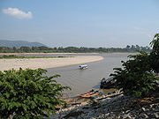
Ruak River
Encyclopedia
Thailand
Thailand , officially the Kingdom of Thailand , formerly known as Siam , is a country located at the centre of the Indochina peninsula and Southeast Asia. It is bordered to the north by Burma and Laos, to the east by Laos and Cambodia, to the south by the Gulf of Thailand and Malaysia, and to the...
-Burma border. It originates within the hills of the Shan State
Shan State
Shan State is a state of Burma . Shan State borders China to the north, Laos to the east, and Thailand to the south, and five administrative divisions of Burma in the west. Largest of the 14 administrative divisions by land area, Shan State covers 155,800 km², almost a quarter of the total...
(Burma), and becomes the boundary river between Thailand and Burma at the confluence with the Mae Sai River
Mae Sai River
Mae Sai River is a river that is the natural border between Thailand and Myanmar. It passes under Phahonyothin Road.Upstream of the Mae Sai River was located at Myanmar....
at the northernmost point of Thailand. It then meanders to the east until it empties into the Mekong
Mekong
The Mekong is a river that runs through China, Burma, Laos, Thailand, Cambodia and Vietnam. It is the world's 10th-longest river and the 7th-longest in Asia. Its estimated length is , and it drains an area of , discharging of water annually....
River at Ban Sop Ruak, Tambon Wiang, Chiang Saen district
Amphoe Chiang Saen
Chiang Saen is a district in the northern part of Chiang Rai Province, northern Thailand.-History:According to an ancient chronicle, the original city of Chiang Saen was built in 545 in an area called Yonok, by Tai migrants from the Chinese province of Yunnan, and was an important city of the...
, Chiang Rai Province
Chiang Rai Province
Chiang Rai is the northernmost province of Thailand. Neighbouring provinces are Phayao, Lampang and Chiang Mai. In the north it borders Shan State of Myanmar and Bokeo of Laos.-Geography:...
. The boundary section of the river is 26.75 km long.