

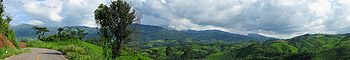
Thai highlands
Encyclopedia
Thailand
Thailand , officially the Kingdom of Thailand , formerly known as Siam , is a country located at the centre of the Indochina peninsula and Southeast Asia. It is bordered to the north by Burma and Laos, to the east by Laos and Cambodia, to the south by the Gulf of Thailand and Malaysia, and to the...
that are part of the range of hills extending through Laos
Laos
Laos Lao: ສາທາລະນະລັດ ປະຊາທິປະໄຕ ປະຊາຊົນລາວ Sathalanalat Paxathipatai Paxaxon Lao, officially the Lao People's Democratic Republic, is a landlocked country in Southeast Asia, bordered by Burma and China to the northwest, Vietnam to the east, Cambodia to the south and Thailand to the west...
, Burma and China
China
Chinese civilization may refer to:* China for more general discussion of the country.* Chinese culture* Greater China, the transnational community of ethnic Chinese.* History of China* Sinosphere, the area historically affected by Chinese culture...
and linking to the Himalayas
Himalayas
The Himalaya Range or Himalaya Mountains Sanskrit: Devanagari: हिमालय, literally "abode of snow"), usually called the Himalayas or Himalaya for short, is a mountain range in Asia, separating the Indian subcontinent from the Tibetan Plateau...
, of which they may be considered foothills.
Geography
Broadly defined there are two mountaineous subsystems in the north of Thailand:- The eastern part of the Shan HillsShan HillsThe Shan Hills , also known as Shan Highland, are part of the range of hills that extends through Yunnan to Burma and Thailand, linking to the Himalayas, of which they may be considered foothills.-Etymology:...
or Shan Highland in the northwest. This area has the highest elevations, with Doi InthanonDoi InthanonDoi Inthanon ) is the highest mountain in Thailand. It is located in Mae Chaem District. The mountain was also known in the past as Doi Luang or Doi Ang Ka, meaning the crow's pond top. Near the mountain's base was a pond where many crows gathered...
, the highest point in Thailand, reaching 2565 metres (8,415 ft). - The remaining mountaineous region that stretches into northern Laos, which does not have a definite name, but is generally defined as Hills of Northern Thailand.
Description
Northern Thailand is characterized by a pattern of generally steep hill ranges, intermontane basins and alluvial gorges. Altitudes are generally moderate, little above 2,000 m for the highest summits. There is a wide range of elevations though, with floors ranging between 500 m and as low as 200 m above sea level. Layers of alluviumAlluvium
Alluvium is loose, unconsolidated soil or sediments, eroded, deposited, and reshaped by water in some form in a non-marine setting. Alluvium is typically made up of a variety of materials, including fine particles of silt and clay and larger particles of sand and gravel...
are superimposed on hard rock.
This area is largely drained by rivers Ping
Ping River
The Ping River , along with the Nan River, is one of the two main contributaries of Chao Phraya River. It originates at Doi Chiang Dao in Chiang Dao district, Chiang Mai Province. After passing Chiang Mai town, it flows though the provinces Lamphun, Tak, and Kamphaeng Phet...
, Wang
Wang River
The Wang River is a river in northern Thailand.-Geography:The Wang River is altogether 335nsnp;km long. Its waters flow from north to south. One of the principal settlements along the river is Lampang, which is situated on the north bank of a curve in the river. From Lampang, the river extends...
, Yom
Yom River
The Yom River is the dime main tributary of the Nan River . The Yom originates in Pong district, Phayao Province, Thailand...
and Nan
Nan River
The Nan River is a river in Thailand. It is one of the most important tributaries of the Chao Phraya River.-Geography:The Nan River originates in Nan Province. The provinces along the river after Nan Province are Uttaradit, Phitsanulok and Phichit. The Yom River joins the Nan River at Chum Saeng...
, all tributaries of the Chao Phraya River
Chao Phraya River
The Chao Phraya is a major river in Thailand, with its low alluvial plain forming the centre of the country. It runs through Bangkok, the capital city, and then empties into the Gulf of Thailand.-Etymology:...
. The ranges separating the main rivers are generally steep, high and continuous. Towards the east, as well as in the Wang and Yom drainage basins, they are lower. Here the ranges consist of Permo-Carboniferous
Permo-Carboniferous
The Permo-Carboniferous refers to the time period including the latter parts of the Carboniferous and early part of the Permian period. Permo-Carboniferous rocks are in places not differentiated because of the presence of transitional fossils, and also where no conspicuous stratigraphic break is...
limestone
Limestone
Limestone is a sedimentary rock composed largely of the minerals calcite and aragonite, which are different crystal forms of calcium carbonate . Many limestones are composed from skeletal fragments of marine organisms such as coral or foraminifera....
, which makes for a more jagged and steep relief, despite the more moderate height.
Towards the Lao border the divide to the Mekong
Mekong
The Mekong is a river that runs through China, Burma, Laos, Thailand, Cambodia and Vietnam. It is the world's 10th-longest river and the 7th-longest in Asia. Its estimated length is , and it drains an area of , discharging of water annually....
basin becomes higher with peaks occasionally rising above 1,500 m and streams flowing in narrow steep valleys.
Inhabitation
The Thai highlands have been inhabited with hill tribes who immigrated into the empty region fleeing persecution in their respective Chinese or Tibeto-Burman environments, or simply seeking new land for their shifting agricultural productions system. At higher altitutudes, above about 1,000m, a principle crop was opium until the 1990s, when the combined effects of development became evident - from the construction of roads into the remote area, integration of these non-Thai persons into the Thai nation, increasingly efficient policing, and opium replacementOpium replacement
Opium replacement simply means the process of replacing the growing as a cash crop of the opium poppy, the source of morphine and heroin, with non-drug crops...
programs.
Environment
The environment is tropical mountain with clearly delineated wet and dry seasons, cool winter temperatures (frosts occur most years at higher elevations) and a mixed vegetation resulting from capacity of the efficient shifting agricultural system being exceeded and large areas becoming dominated by Imperta cylindrica grass, which is used throughout Thailand as roofing material. Cattle can graze on the grass to an extent, as agricultural scienceAgricultural science
Agricultural science is a broad multidisciplinary field that encompasses the parts of exact, natural, economic and social sciences that are used in the practice and understanding of agriculture. -Agriculture and agricultural science:The two terms are often confused...
research in the 1970s defined, but the longer term environmental care of the region is associated with forestry
Forestry
Forestry is the interdisciplinary profession embracing the science, art, and craft of creating, managing, using, and conserving forests and associated resources in a sustainable manner to meet desired goals, needs, and values for human benefit. Forestry is practiced in plantations and natural stands...
and in the lower reaches, perennial fruit and other trees.