

Cape to Cairo Road
Encyclopedia
British Empire
The British Empire comprised the dominions, colonies, protectorates, mandates and other territories ruled or administered by the United Kingdom. It originated with the overseas colonies and trading posts established by England in the late 16th and early 17th centuries. At its height, it was the...
that would see a road stretch the length of Africa
Africa
Africa is the world's second largest and second most populous continent, after Asia. At about 30.2 million km² including adjacent islands, it covers 6% of the Earth's total surface area and 20.4% of the total land area...
, from Cape Town
Cape Town
Cape Town is the second-most populous city in South Africa, and the provincial capital and primate city of the Western Cape. As the seat of the National Parliament, it is also the legislative capital of the country. It forms part of the City of Cape Town metropolitan municipality...
to Cairo
Cairo
Cairo , is the capital of Egypt and the largest city in the Arab world and Africa, and the 16th largest metropolitan area in the world. Nicknamed "The City of a Thousand Minarets" for its preponderance of Islamic architecture, Cairo has long been a centre of the region's political and cultural life...
, similar to the Pan-American Highway
Pan-American Highway
The Pan-American Highway is a network of roads measuring about in total length. Except for an rainforest break, called the Darién Gap, the road links the mainland nations of the Americas in a connected highway system. According to Guinness World Records, the Pan-American Highway is the world's...
. It will become a reality when the Cairo-Cape Town Highway
Cairo-Cape Town Highway
The Cairo-Cape Town Highway is Trans-African Highway 4 in the transcontinental road network being developed by the United Nations Economic Commission for Africa , the African Development Bank , and the African Union...
project is completed.
History
From about 1890, stalwarts of the British Empire had a grand vision for a road that would stretch across the continent from south to north, running through the British colonies of the time, such as the Union of South AfricaUnion of South Africa
The Union of South Africa is the historic predecessor to the present-day Republic of South Africa. It came into being on 31 May 1910 with the unification of the previously separate colonies of the Cape, Natal, Transvaal and the Orange Free State...
, Southern
Southern Rhodesia
Southern Rhodesia was the name of the British colony situated north of the Limpopo River and the Union of South Africa. From its independence in 1965 until its extinction in 1980, it was known as Rhodesia...
and Northern Rhodesia
Northern Rhodesia
Northern Rhodesia was a territory in south central Africa, formed in 1911. It became independent in 1964 as Zambia.It was initially administered under charter by the British South Africa Company and formed by it in 1911 by amalgamating North-Western Rhodesia and North-Eastern Rhodesia...
and Nyasaland
Nyasaland
Nyasaland or the Nyasaland Protectorate, was a British protectorate located in Africa, which was established in 1907 when the former British Central Africa Protectorate changed its name. Since 1964, it has been known as Malawi....
, Kenya
Kenya
Kenya , officially known as the Republic of Kenya, is a country in East Africa that lies on the equator, with the Indian Ocean to its south-east...
, Sudan
Sudan
Sudan , officially the Republic of the Sudan , is a country in North Africa, sometimes considered part of the Middle East politically. It is bordered by Egypt to the north, the Red Sea to the northeast, Eritrea and Ethiopia to the east, South Sudan to the south, the Central African Republic to the...
and Egypt
Egypt
Egypt , officially the Arab Republic of Egypt, Arabic: , is a country mainly in North Africa, with the Sinai Peninsula forming a land bridge in Southwest Asia. Egypt is thus a transcontinental country, and a major power in Africa, the Mediterranean Basin, the Middle East and the Muslim world...
. One of the main proponents of the route was Cecil John Rhodes
Cecil John Rhodes
Cecil John Rhodes PC, DCL was an English-born South African businessman, mining magnate, and politician. He was the founder of the diamond company De Beers, which today markets 40% of the world's rough diamonds and at one time marketed 90%...
, the man after whom Rhodesia was named, though his preference was for a railway. German East Africa
German East Africa
German East Africa was a German colony in East Africa, which included what are now :Burundi, :Rwanda and Tanganyika . Its area was , nearly three times the size of Germany today....
(Tanganyika
Tanganyika
Tanganyika , later formally the Republic of Tanganyika, was a sovereign state in East Africa from 1961 to 1964. It was situated between the Indian Ocean and the African Great Lakes of Lake Victoria, Lake Malawi and Lake Tanganyika...
, now Tanzania
Tanzania
The United Republic of Tanzania is a country in East Africa bordered by Kenya and Uganda to the north, Rwanda, Burundi, and the Democratic Republic of the Congo to the west, and Zambia, Malawi, and Mozambique to the south. The country's eastern borders lie on the Indian Ocean.Tanzania is a state...
) was a gap in the British territories, but Rhodes in particular felt that Germany ought to be a natural ally. Shortly before his death he had persuaded the German Kaiser
Kaiser
Kaiser is the German title meaning "Emperor", with Kaiserin being the female equivalent, "Empress". Like the Russian Czar it is directly derived from the Latin Emperors' title of Caesar, which in turn is derived from the personal name of a branch of the gens Julia, to which Gaius Julius Caesar,...
to allow access through his colony for the Cape to Cairo telegraph line (which was built as far north as Ujiji
Ujiji
Ujiji is the oldest town in western Tanzania, located about 6 miles south of Kigoma. In 1900, the population was estimated at 10,000 and in 1967 about 4,100. Part of the Kigoma/Ujiji urban area, the regional population was about 50,000 in 1978....
but never completed).
In 1918 Tanganyika became British and the gap in territories was sealed. Even though Egypt became independent in 1922, British influence there was strong enough for Cairo to be viewed as part of the British sphere of interest, and the idea of a road continued.
The road would create cohesion between the British colonies
Colony
In politics and history, a colony is a territory under the immediate political control of a state. For colonies in antiquity, city-states would often found their own colonies. Some colonies were historically countries, while others were territories without definite statehood from their inception....
of Africa, it was thought, and give Britain the most important and dominant political and economic influence over the continent, securing its position as a global colonial power. The road would also link some of the most important cities on the continent, including Cape Town
Cape Town
Cape Town is the second-most populous city in South Africa, and the provincial capital and primate city of the Western Cape. As the seat of the National Parliament, it is also the legislative capital of the country. It forms part of the City of Cape Town metropolitan municipality...
, Johannesburg
Johannesburg
Johannesburg also known as Jozi, Jo'burg or Egoli, is the largest city in South Africa, by population. Johannesburg is the provincial capital of Gauteng, the wealthiest province in South Africa, having the largest economy of any metropolitan region in Sub-Saharan Africa...
, Pretoria
Pretoria
Pretoria is a city located in the northern part of Gauteng Province, South Africa. It is one of the country's three capital cities, serving as the executive and de facto national capital; the others are Cape Town, the legislative capital, and Bloemfontein, the judicial capital.Pretoria is...
, Harare
Harare
Harare before 1982 known as Salisbury) is the largest city and capital of Zimbabwe. It has an estimated population of 1,600,000, with 2,800,000 in its metropolitan area . Administratively, Harare is an independent city equivalent to a province. It is Zimbabwe's largest city and its...
(then Salisbury), Lusaka
Lusaka
Lusaka is the capital and largest city of Zambia. It is located in the southern part of the central plateau, at an elevation of about 1,300 metres . It has a population of about 1.7 million . It is a commercial centre as well as the centre of government, and the four main highways of Zambia head...
, Nairobi
Nairobi
Nairobi is the capital and largest city of Kenya. The city and its surrounding area also forms the Nairobi County. The name "Nairobi" comes from the Maasai phrase Enkare Nyirobi, which translates to "the place of cool waters". However, it is popularly known as the "Green City in the Sun" and is...
, Khartoum
Khartoum
Khartoum is the capital and largest city of Sudan and of Khartoum State. It is located at the confluence of the White Nile flowing north from Lake Victoria, and the Blue Nile flowing west from Ethiopia. The location where the two Niles meet is known as "al-Mogran"...
and Cairo
Cairo
Cairo , is the capital of Egypt and the largest city in the Arab world and Africa, and the 16th largest metropolitan area in the world. Nicknamed "The City of a Thousand Minarets" for its preponderance of Islamic architecture, Cairo has long been a centre of the region's political and cultural life...
.
France
France
The French Republic , The French Republic , The French Republic , (commonly known as France , is a unitary semi-presidential republic in Western Europe with several overseas territories and islands located on other continents and in the Indian, Pacific, and Atlantic oceans. Metropolitan France...
had a rival strategy in the late 1890s to link its colonies from west to east across the continent, Senegal
Senegal
Senegal , officially the Republic of Senegal , is a country in western Africa. It owes its name to the Sénégal River that borders it to the east and north...
to Djibouti
Djibouti
Djibouti , officially the Republic of Djibouti , is a country in the Horn of Africa. It is bordered by Eritrea in the north, Ethiopia in the west and south, and Somalia in the southeast. The remainder of the border is formed by the Red Sea and the Gulf of Aden at the east...
. Southern Sudan
Sudan
Sudan , officially the Republic of the Sudan , is a country in North Africa, sometimes considered part of the Middle East politically. It is bordered by Egypt to the north, the Red Sea to the northeast, Eritrea and Ethiopia to the east, South Sudan to the south, the Central African Republic to the...
and Ethiopia
Ethiopia
Ethiopia , officially known as the Federal Democratic Republic of Ethiopia, is a country located in the Horn of Africa. It is the second-most populous nation in Africa, with over 82 million inhabitants, and the tenth-largest by area, occupying 1,100,000 km2...
were in the way, but France sent expeditions in 1897 to establish a protectorate in southern Sudan and to find a route across Ethiopia. The scheme foundered when a British flotilla on the Nile
Nile
The Nile is a major north-flowing river in North Africa, generally regarded as the longest river in the world. It is long. It runs through the ten countries of Sudan, South Sudan, Burundi, Rwanda, Democratic Republic of the Congo, Tanzania, Kenya, Ethiopia, Uganda and Egypt.The Nile has two major...
confronted the French expedition at the point of intersection between the French and British routes, leading to the Fashoda Incident
Fashoda Incident
The Fashoda Incident was the climax of imperial territorial disputes between Britain and France in Eastern Africa. A French expedition to Fashoda on the White Nile sought to gain control of the Nile River and thereby force Britain out of Egypt. The British held firm as Britain and France were on...
and eventual diplomatic defeat for France.
One of the biggest problems was the decline of the Empire and fragmentation of the British colonies — after Egypt, Sudan was the next to become independent in 1956 — which put paid to the colonial part of the dream.
The first known attempt to drive a vehicle from Cape Town to Cairo was by a Captain Kelsey in 1913-14 but this came to an untimely end when he was killed by a leopard in Rhodesia. The first successful journey was the 1924 expedition led by Major Chaplin Court Treatt which drove two Crossley
Crossley Motors
Crossley Motors was a British motor vehicle manufacturer based in Manchester, England. They produced approximately 19,000 high quality cars from 1904 until 1938, 5,500 buses from 1926 until 1958 and 21,000 goods and military vehicles from 1914 to 1945.Crossley Brothers, originally...
light trucks leaving Cape Town on 23 September 1924 and arriving in Cairo on 24 January 1926.
The route today
Even today, the road remains a somewhat elusive idea, and there is no continuous all weather route, especially between Kenya and Egypt, and it is not feasible to drive even off-road vehicles between Sudan and Egypt as the tracks are closed, they have to go by boat on Lake NasserLake Nasser
Lake Nasser is a vast reservoir in southern Egypt, and northern Sudan, and is one of the largest man-made lakes in the world. Strictly, "Lake Nasser" refers only to the much larger portion of the lake that is in Egyptian territory , with the Sudanese preferring to call their smaller body of water...
or the Red Sea
Red Sea
The Red Sea is a seawater inlet of the Indian Ocean, lying between Africa and Asia. The connection to the ocean is in the south through the Bab el Mandeb strait and the Gulf of Aden. In the north, there is the Sinai Peninsula, the Gulf of Aqaba, and the Gulf of Suez...
from Port Sudan
Port Sudan
Port Sudan is the capital of Red Sea State, Sudan; it has 489,725 residents . Located on the Red Sea, it is the Republic of Sudan's main port city.-History:...
.
Starting from the south, the first section of the road that runs through South Africa is called the N1
N1 (South Africa)
The N1 is a South African National Route, running from Cape Town to Beit Bridge on the border with Zimbabwe. It is also the main road link between Johannesburg and Cape Town, and forms the first section of the famed Cape to Cairo Road....
, linking Cape Town in the far south of the continent with Beit Bridge, located on the Limpopo River
Limpopo River
The Limpopo River rises in central southern Africa, and flows generally eastwards to the Indian Ocean. It is around long, with a drainage basin in size. Its mean annual discharge is 170 m³/s at its mouth...
between South Africa and Zimbabwe
Zimbabwe
Zimbabwe is a landlocked country located in the southern part of the African continent, between the Zambezi and Limpopo rivers. It is bordered by South Africa to the south, Botswana to the southwest, Zambia and a tip of Namibia to the northwest and Mozambique to the east. Zimbabwe has three...
. There are numerous alternative routes, especially in South Africa, and two possible routes through Zimbabwe, via Bulawayo
Bulawayo
Bulawayo is the second largest city in Zimbabwe after the capital Harare, with an estimated population in 2010 of 2,000,000. It is located in Matabeleland, 439 km southwest of Harare, and is now treated as a separate provincial area from Matabeleland...
or Harare. The link through Harare to Lusaka in Zambia
Zambia
Zambia , officially the Republic of Zambia, is a landlocked country in Southern Africa. The neighbouring countries are the Democratic Republic of the Congo to the north, Tanzania to the north-east, Malawi to the east, Mozambique, Zimbabwe, Botswana and Namibia to the south, and Angola to the west....
is seen as the Cape to Cairo road, and the main north-south axis of Lusaka is named Cairo Road
Cairo Road
Cairo Road is the main thoroughfare of Lusaka, Zambia and the principal business, retail and services centre of the city. It was a section of the Great North Road and was so named because it is a link in Cecil Rhodes' then dream of a Cape to Cairo Road through British colonies in Africa.Cairo Road...
for this reason. From Lusaka, Zambia's Great North Road
Great North Road (Zambia)
The Great North Road is a major route in Zambia, running north from Lusaka through Kabwe, Kapiri Mposhi Serenje, Mpika, Kasama, Mbala and Mpulungu. 82km North of Mpika is a signposted left turn onto a well maintained gravel road leading to Shiwa Ng'andu and Kapishya Hot Springs...
continues the route into Tanzania
Tanzania
The United Republic of Tanzania is a country in East Africa bordered by Kenya and Uganda to the north, Rwanda, Burundi, and the Democratic Republic of the Congo to the west, and Zambia, Malawi, and Mozambique to the south. The country's eastern borders lie on the Indian Ocean.Tanzania is a state...
. The surface may be badly potholed in some sections through Zambia and points north. In Tanzania there are a number of roads could be deemed to be part of the route, the clear definitions and markings that are characteristic of the Pan-American Highway do not apply here. Most would consider it to be the road from Tunduma
Tunduma
Tunduma is a Tanzanian border town in Mbeya Region with border posts for both the Tanzam Highway and the TAZARA railway linking the two countries. It is...
on the Tanzania-Zambia border, through Morogoro
Morogoro
Morogoro is a city with an urban population of 206,868 in the southern highlands of Tanzania, 190 km west of Dar es Salaam. It is the capital of the Morogoro Region...
to the Arusha
Arusha
Arusha is a city in northern Tanzania. It is the capital of the Arusha Region, which claims a population of 1,288,088, including 281,608 for the Arusha District . Arusha is surrounded by some of Africa's most famous landscapes and national parks...
turnoff, and north to Arusha, then to Nairobi in Kenya. There is a marker in Arusha, Tanzania, to indicate the midpoint of the road.
Up to Nairobi and a little beyond, the road is tarred all the way from Cape Town, but between Kenya and Aswan
Aswan
Aswan , formerly spelled Assuan, is a city in the south of Egypt, the capital of the Aswan Governorate.It stands on the east bank of the Nile at the first cataract and is a busy market and tourist centre...
in Egypt a four-wheel drive vehicle or a truck is necessary as most of the road is a rough track which may be impassable after rain. Kenya has a tarred highway to its border with Sudan but the roads in southern Sudan are very poor and made frequently impassable, so that even without the conflicts that have afflicted Sudan, the route through Ethiopia
Ethiopia
Ethiopia , officially known as the Federal Democratic Republic of Ethiopia, is a country located in the Horn of Africa. It is the second-most populous nation in Africa, with over 82 million inhabitants, and the tenth-largest by area, occupying 1,100,000 km2...
is generally preferred by overland travellers. The route from Isiolo
Isiolo
Isiolo is a town in the Eastern Province, Kenya. It is situated in the Upper Eastern sub-region, and lies 285 kilometres north of Nairobi, the capital city of Kenya. The town grew around the local military camps, much of the population being descended from former Somali soldiers who had fought in...
in Kenya to Moyale
Moyale
Moyale is a market town on the border of Ethiopia and Kenya, which is split between the two countries: the larger portion is in Ethiopia , and the smaller is in Kenya . There are four disputed locations within the Moyale district between the Somali and Oromo regions...
on the Ethiopian border through the northern Kenyan desert is rough and has sometimes been dangerous due to bandits. Through Ethiopia the route is mainly tarred but some sections may have deteriorated severely. A track from Lake Tana
Lake Tana
Lake Tana is the source of the Blue Nile and is the largest lake in Ethiopia...
to Gedaref takes the route into Sudan.
The most difficult section in the whole Cape to Cairo journey is the track across the Nubian Desert
Nubian Desert
The Nubian Desert is in the eastern region of the Sahara Desert, spanning approximately 400,000 km² of northeastern Sudan between the Nile and the Red Sea. The arid region, a largely sandstone plateau, has lots of wadis flowing towards the Nile. There is virtually no rainfall in the Nubian,...
in northern Sudan between Atbara and Wadi Halfa
Wadi Halfa
Wadi Halfa is a city in the state of Northern, in northern Sudan, on the shores of Lake Nubia . It is the terminus of a rail line from Khartoum and the point where goods are transferred from rail to ferries going down the Lake Nasser...
, but there is also a railway traversing this route which can take vehicles in piggyback fashion. At Wadi Halfa on Lake Nasser
Lake Nasser
Lake Nasser is a vast reservoir in southern Egypt, and northern Sudan, and is one of the largest man-made lakes in the world. Strictly, "Lake Nasser" refers only to the much larger portion of the lake that is in Egyptian territory , with the Sudanese preferring to call their smaller body of water...
there is a break in the road, and not even a track continues around the lake, but ferries take vehicles to Aswan
Aswan
Aswan , formerly spelled Assuan, is a city in the south of Egypt, the capital of the Aswan Governorate.It stands on the east bank of the Nile at the first cataract and is a busy market and tourist centre...
in Egypt. Tarred highways continue the route to Cairo. An Egyptian and a Sudanese company committed in January, 2010 to build a 400 km stretch of highway between Aswan and Dongola
Dongola
Dongola , also spelled Dunqulah, and formerly known as Al 'Urdi, is the capital of the state of Northern in Sudan, on the banks of the Nile. It should not be confused with Old Dongola, an ancient city located 80 km upstream on the opposite bank....
in Sudan.
The stretch of highway between Dongola and Wadi Halfa is now complete (as of June 2010) but there is still no open overland border between Sudan and Egypt, making the Ferry from Wadi Halfa to Aswan the only option.
A number of adventure travel companies offer Cape to Cairo overland expeditions using four-wheel drive trucks with bus bodies.
The future
The United Nations Economic Commission for AfricaUnited Nations Economic Commission for Africa
The United Nations Economic Commission for Africa was established in 1958 by the United Nations Economic and Social Council to encourage economic cooperation among its member states following a recommendation of the United Nations General Assembly.It is one of five regional commissions.The ECA...
, the African Development Bank
African Development Bank
The African Development Bank Group is a development bank established in 1964 with the intention of promoting economic and social development in Africa...
, and the African Union
African Union
The African Union is a union consisting of 54 African states. The only all-African state not in the AU is Morocco. Established on 9 July 2002, the AU was formed as a successor to the Organisation of African Unity...
, have a project to complete the Cairo-Cape Town Highway
Cairo-Cape Town Highway
The Cairo-Cape Town Highway is Trans-African Highway 4 in the transcontinental road network being developed by the United Nations Economic Commission for Africa , the African Development Bank , and the African Union...
as part of the Trans-African Highway network.
See also
- Cape to CairoCape To CairoCape to Cairo may refer to:* the Cape to Cairo Railway* the Cape to Cairo Red Line, the 19th century concept of a British-dominated Africa, promoted by Cecil Rhodes* the Cape to Cairo Road...
- Cape to Cairo Railway
- Cape to Cairo Red Line
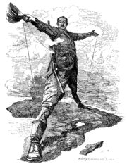
- The Rhodes ColossusThe Rhodes ColossusThe Rhodes Colossus is an iconic editorial cartoon of the Scramble for Africa period, depicting British colonialist Cecil Rhodes as a giant standing over the continent....
- Cairo-Cape Town HighwayCairo-Cape Town HighwayThe Cairo-Cape Town Highway is Trans-African Highway 4 in the transcontinental road network being developed by the United Nations Economic Commission for Africa , the African Development Bank , and the African Union...
- Scramble for AfricaScramble for AfricaThe Scramble for Africa, also known as the Race for Africa or Partition of Africa was a process of invasion, occupation, colonization and annexation of African territory by European powers during the New Imperialism period, between 1881 and World War I in 1914...
- Fashoda IncidentFashoda IncidentThe Fashoda Incident was the climax of imperial territorial disputes between Britain and France in Eastern Africa. A French expedition to Fashoda on the White Nile sought to gain control of the Nile River and thereby force Britain out of Egypt. The British held firm as Britain and France were on...