

Cape Fold Belt
Encyclopedia
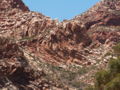
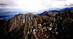
The Cape Fold Belt is the folded
sedimentary
sequence of rocks in the southwestern corner of South Africa
. It is related to the Ventana Mountains near Bahía Blanca
in Argentina
. The rocks are generally sandstones and shales, with shales forming the valleys and the erosion resistant sandstones forming the parallel mountain ranges, reaching a maximum height at Seweweekspoortpiek
(Afrikaans: Seven Weeks Defile Peak) at 2325 m.
The rocks were laid down as sediments in a coastal delta environment upon the Malmesbury unconformity
in the Ordovician
Period (450 ma), with the folding subsequently occurring in the Carboniferous
and Permian
periods during the merging of the supercontinent Pangaea
. Even though the mountains are very old by Andean and Alpine standards, they remain steep and rugged due to their quarzitic sandstone
geology
making them very resistant to weathering
. The famous Table Mountain
is made up of hard rocks of the Peninsula Formation of the Table Mountain Group.
The geographic range of the Cape Fold Belt is from Cape Town
in the west and the Cederberg
Mountains in the northwest to Port Elizabeth in the east.
The mountains, although mediocre in height by world standards, remain majestic and dramatic. This is due in part to numerous geological factors; The ranges usually have few to no foothills and rise directly from the valley floor. The mountain's base is usually at or near sea level.
 The mountains are not particularly ancient, despite their old-looking appearance. They are considered middle-aged in geologic terms. They were created during continental collision when Pangaea
, the supercontinent formed from the late Carboniferous
to Permian
periods. Their stature is mostly due to their weather-resistant rocks of quartzitic
sandstone
, with the shale
formations generally forming the valleys, capped by alluvial
deposits, which are generally Quaternary
in age.
The mountains were folded during this period and were still buried beneath the Earth's surface. Due to the extreme temperatures and lithic pressure at these depths, folding was not a brittle process, as the rocks retained a "plastic" constituency, making the Cape Fold Mountains spectacular in their exposed folded, faulted and twisted sedimentary strata. A number of parallel faults still runs roughly parallel with the coast, having formed during the Gondwanaland rift
ing when South America separated from Africa. Patagonia
was to the west of Cape Town
and the Falkland Islands
were to the south during the Jurassic
Period prior to separation. This faulting has caused the Table Mountain Sandstone
to be exposed closer to and above sea level close to the coast, but gradually becoming deeper embedded in the overlying strata further inland, excluding areas where folding has caused anticline
s to expose the rocks higher up (eg. Swartberg
Mountains north of the Oudtshoorn Fault.
The opening of Pangaea
and subsequently Gondwanaland also aided in their "conservation" as a range, as the Cape Supergroup of rocks were capped by the deposition of the Karoo Sequence of sedimentary deposits, including the Dwyka Formation, which is compacted glacial till
deposited during the late Permian
southern ice age
.
 The largest individual ranges within the Cape Fold Belt include (translations in brackets) from west to east:
Fold (geology)
The term fold is used in geology when one or a stack of originally flat and planar surfaces, such as sedimentary strata, are bent or curved as a result of permanent deformation. Synsedimentary folds are those due to slumping of sedimentary material before it is lithified. Folds in rocks vary in...
sedimentary
Sedimentary rock
Sedimentary rock are types of rock that are formed by the deposition of material at the Earth's surface and within bodies of water. Sedimentation is the collective name for processes that cause mineral and/or organic particles to settle and accumulate or minerals to precipitate from a solution....
sequence of rocks in the southwestern corner of South Africa
South Africa
The Republic of South Africa is a country in southern Africa. Located at the southern tip of Africa, it is divided into nine provinces, with of coastline on the Atlantic and Indian oceans...
. It is related to the Ventana Mountains near Bahía Blanca
Bahía Blanca
Bahía Blanca is a city located in the south-west of the province of Buenos Aires, Argentina, by the Atlantic Ocean, and seat of government of Bahía Blanca Partido. It has a population of 274,509 inhabitants according to the...
in Argentina
Argentina
Argentina , officially the Argentine Republic , is the second largest country in South America by land area, after Brazil. It is constituted as a federation of 23 provinces and an autonomous city, Buenos Aires...
. The rocks are generally sandstones and shales, with shales forming the valleys and the erosion resistant sandstones forming the parallel mountain ranges, reaching a maximum height at Seweweekspoortpiek
Seweweekspoortpiek
Seweweekspoortpiek is the highest mountain in the Cape Fold Belt of South Africa. Along with its western neighbour, Du Toits Peak, it qualifies as an Ultra and these are the only two in the western part of the country.-External links:*...
(Afrikaans: Seven Weeks Defile Peak) at 2325 m.
The rocks were laid down as sediments in a coastal delta environment upon the Malmesbury unconformity
Unconformity
An unconformity is a buried erosion surface separating two rock masses or strata of different ages, indicating that sediment deposition was not continuous. In general, the older layer was exposed to erosion for an interval of time before deposition of the younger, but the term is used to describe...
in the Ordovician
Ordovician
The Ordovician is a geologic period and system, the second of six of the Paleozoic Era, and covers the time between 488.3±1.7 to 443.7±1.5 million years ago . It follows the Cambrian Period and is followed by the Silurian Period...
Period (450 ma), with the folding subsequently occurring in the Carboniferous
Carboniferous
The Carboniferous is a geologic period and system that extends from the end of the Devonian Period, about 359.2 ± 2.5 Mya , to the beginning of the Permian Period, about 299.0 ± 0.8 Mya . The name is derived from the Latin word for coal, carbo. Carboniferous means "coal-bearing"...
and Permian
Permian
The PermianThe term "Permian" was introduced into geology in 1841 by Sir Sir R. I. Murchison, president of the Geological Society of London, who identified typical strata in extensive Russian explorations undertaken with Edouard de Verneuil; Murchison asserted in 1841 that he named his "Permian...
periods during the merging of the supercontinent Pangaea
Pangaea
Pangaea, Pangæa, or Pangea is hypothesized as a supercontinent that existed during the Paleozoic and Mesozoic eras about 250 million years ago, before the component continents were separated into their current configuration....
. Even though the mountains are very old by Andean and Alpine standards, they remain steep and rugged due to their quarzitic sandstone
Sandstone
Sandstone is a sedimentary rock composed mainly of sand-sized minerals or rock grains.Most sandstone is composed of quartz and/or feldspar because these are the most common minerals in the Earth's crust. Like sand, sandstone may be any colour, but the most common colours are tan, brown, yellow,...
geology
Geology
Geology is the science comprising the study of solid Earth, the rocks of which it is composed, and the processes by which it evolves. Geology gives insight into the history of the Earth, as it provides the primary evidence for plate tectonics, the evolutionary history of life, and past climates...
making them very resistant to weathering
Weathering
Weathering is the breaking down of rocks, soils and minerals as well as artificial materials through contact with the Earth's atmosphere, biota and waters...
. The famous Table Mountain
Table Mountain
Table Mountain is a flat-topped mountain forming a prominent landmark overlooking the city of Cape Town in South Africa, and is featured in the flag of Cape Town and other local government insignia. It is a significant tourist attraction, with many visitors using the cableway or hiking to the top...
is made up of hard rocks of the Peninsula Formation of the Table Mountain Group.
The geographic range of the Cape Fold Belt is from Cape Town
Cape Town
Cape Town is the second-most populous city in South Africa, and the provincial capital and primate city of the Western Cape. As the seat of the National Parliament, it is also the legislative capital of the country. It forms part of the City of Cape Town metropolitan municipality...
in the west and the Cederberg
Cederberg
The Cederberg mountains and nature reserve are located near Clanwilliam, approximately 300 km north of Cape Town, South Africa at about . The mountain range is named after the endangered Clanwilliam Cedar , which is a tree endemic to the area. The mountains are noted for dramatic rock...
Mountains in the northwest to Port Elizabeth in the east.
The mountains, although mediocre in height by world standards, remain majestic and dramatic. This is due in part to numerous geological factors; The ranges usually have few to no foothills and rise directly from the valley floor. The mountain's base is usually at or near sea level.
Orogeny
Pangaea
Pangaea, Pangæa, or Pangea is hypothesized as a supercontinent that existed during the Paleozoic and Mesozoic eras about 250 million years ago, before the component continents were separated into their current configuration....
, the supercontinent formed from the late Carboniferous
Carboniferous
The Carboniferous is a geologic period and system that extends from the end of the Devonian Period, about 359.2 ± 2.5 Mya , to the beginning of the Permian Period, about 299.0 ± 0.8 Mya . The name is derived from the Latin word for coal, carbo. Carboniferous means "coal-bearing"...
to Permian
Permian
The PermianThe term "Permian" was introduced into geology in 1841 by Sir Sir R. I. Murchison, president of the Geological Society of London, who identified typical strata in extensive Russian explorations undertaken with Edouard de Verneuil; Murchison asserted in 1841 that he named his "Permian...
periods. Their stature is mostly due to their weather-resistant rocks of quartzitic
Quartzite
Quartzite is a hard metamorphic rock which was originally sandstone. Sandstone is converted into quartzite through heating and pressure usually related to tectonic compression within orogenic belts. Pure quartzite is usually white to gray, though quartzites often occur in various shades of pink...
sandstone
Sandstone
Sandstone is a sedimentary rock composed mainly of sand-sized minerals or rock grains.Most sandstone is composed of quartz and/or feldspar because these are the most common minerals in the Earth's crust. Like sand, sandstone may be any colour, but the most common colours are tan, brown, yellow,...
, with the shale
Shale
Shale is a fine-grained, clastic sedimentary rock composed of mud that is a mix of flakes of clay minerals and tiny fragments of other minerals, especially quartz and calcite. The ratio of clay to other minerals is variable. Shale is characterized by breaks along thin laminae or parallel layering...
formations generally forming the valleys, capped by alluvial
Alluvium
Alluvium is loose, unconsolidated soil or sediments, eroded, deposited, and reshaped by water in some form in a non-marine setting. Alluvium is typically made up of a variety of materials, including fine particles of silt and clay and larger particles of sand and gravel...
deposits, which are generally Quaternary
Quaternary
The Quaternary Period is the most recent of the three periods of the Cenozoic Era in the geologic time scale of the ICS. It follows the Neogene Period, spanning 2.588 ± 0.005 million years ago to the present...
in age.
The mountains were folded during this period and were still buried beneath the Earth's surface. Due to the extreme temperatures and lithic pressure at these depths, folding was not a brittle process, as the rocks retained a "plastic" constituency, making the Cape Fold Mountains spectacular in their exposed folded, faulted and twisted sedimentary strata. A number of parallel faults still runs roughly parallel with the coast, having formed during the Gondwanaland rift
Rift
In geology, a rift or chasm is a place where the Earth's crust and lithosphere are being pulled apart and is an example of extensional tectonics....
ing when South America separated from Africa. Patagonia
Patagonia
Patagonia is a region located in Argentina and Chile, integrating the southernmost section of the Andes mountains to the southwest towards the Pacific ocean and from the east of the cordillera to the valleys it follows south through Colorado River towards Carmen de Patagones in the Atlantic Ocean...
was to the west of Cape Town
Cape Town
Cape Town is the second-most populous city in South Africa, and the provincial capital and primate city of the Western Cape. As the seat of the National Parliament, it is also the legislative capital of the country. It forms part of the City of Cape Town metropolitan municipality...
and the Falkland Islands
Falkland Islands
The Falkland Islands are an archipelago in the South Atlantic Ocean, located about from the coast of mainland South America. The archipelago consists of East Falkland, West Falkland and 776 lesser islands. The capital, Stanley, is on East Falkland...
were to the south during the Jurassic
Jurassic
The Jurassic is a geologic period and system that extends from about Mya to Mya, that is, from the end of the Triassic to the beginning of the Cretaceous. The Jurassic constitutes the middle period of the Mesozoic era, also known as the age of reptiles. The start of the period is marked by...
Period prior to separation. This faulting has caused the Table Mountain Sandstone
Table Mountain sandstone
The Table Mountain Sandstone is a group of rock formations within the Cape Supergroup sequence of rocks. Although still widely used in common parlance, the term TMS is no longer formally recognized; the correct name is the "Table Mountain Group" . The sequence is dominated by quartzites of very...
to be exposed closer to and above sea level close to the coast, but gradually becoming deeper embedded in the overlying strata further inland, excluding areas where folding has caused anticline
Anticline
In structural geology, an anticline is a fold that is convex up and has its oldest beds at its core. The term is not to be confused with antiform, which is a purely descriptive term for any fold that is convex up. Therefore if age relationships In structural geology, an anticline is a fold that is...
s to expose the rocks higher up (eg. Swartberg
Swartberg
The Swartberg mountains make up a mountain range that runs roughly east-west along the northern edge of the semi-arid Little Karoo in the Western Cape province of South Africa...
Mountains north of the Oudtshoorn Fault.
The opening of Pangaea
Pangaea
Pangaea, Pangæa, or Pangea is hypothesized as a supercontinent that existed during the Paleozoic and Mesozoic eras about 250 million years ago, before the component continents were separated into their current configuration....
and subsequently Gondwanaland also aided in their "conservation" as a range, as the Cape Supergroup of rocks were capped by the deposition of the Karoo Sequence of sedimentary deposits, including the Dwyka Formation, which is compacted glacial till
Till
thumb|right|Closeup of glacial till. Note that the larger grains in the till are completely surrounded by the matrix of finer material , and this characteristic, known as matrix support, is diagnostic of till....
deposited during the late Permian
Permian
The PermianThe term "Permian" was introduced into geology in 1841 by Sir Sir R. I. Murchison, president of the Geological Society of London, who identified typical strata in extensive Russian explorations undertaken with Edouard de Verneuil; Murchison asserted in 1841 that he named his "Permian...
southern ice age
Ice age
An ice age or, more precisely, glacial age, is a generic geological period of long-term reduction in the temperature of the Earth's surface and atmosphere, resulting in the presence or expansion of continental ice sheets, polar ice sheets and alpine glaciers...
.
The ranges
- CederbergCederbergThe Cederberg mountains and nature reserve are located near Clanwilliam, approximately 300 km north of Cape Town, South Africa at about . The mountain range is named after the endangered Clanwilliam Cedar , which is a tree endemic to the area. The mountains are noted for dramatic rock...
Mountains (Cedar) - Olifants River Mountains (Elephant's)
- Piketberg (Picket)
- WinterhoekWinterhoekThe Winterhoekberge are located in the Western Cape province of South Africa and are part of the Cape Fold Belt. They rise to a maximum height of 2077m just north of the town of Tulbagh as Grootwinterhoekpiek...
Mountains (Winter corner) - Skurweberge (Rough or scaly)
- Hex River MountainsHex River mountainsThe Hex River Mountains make up the second highest mountain range in the Western Cape province of South Africa and are located 120km north-east of Cape Town. They form part of a large anticline in the Cape Fold Belt mountain system and form a north-east, south-west trending mountain system forming...
(Witch river) - Du Toitskloof Mountains (a French surname: Du Toits canyon )
- DrakensteinDrakensteinThe Drakenstein Mountains are part of the Cape Fold Belt and are in the Western Cape province of South Africa; they were named in honour of H.A. van Reede tot Drakenstein who visited the Cape as Commissioner-General in 1685; Drakenstein was the name of his estate in the Netherlands...
Mountains (Dragon stone) - SimonsbergSimonsbergSimonsberg is part of the Cape Fold Belt in the Western Cape province of South Africa and is located between the towns of Stellenbosch, Paarl and Franschhoek, forming a prominent 1399m high mountain, as it is detached from the other ranges in the winelands region...
(Simon's) - Hottentots-HollandHottentots-HollandThe Hottentots Holland mountain range is part of the Cape Fold Belt in the Western Cape, South Africa. The range forms a barrier between the Cape Town metropolitan area and the southern Overberg coast. The range is primarily composed of Table Mountain Sandstone and forms an impressive range to the...
Mountains (Hottentot: old name for Khoi aboriginal inhabitants) - KogelbergKogelbergThe Kogelberg is a range of mountains along the False Bay coast in the Western Cape of South Africa. They form part of the Cape Fold Belt and start south of Grabouw and form a steep coastal range to Kleinmond. The Kogelberg area has the steepest and highest drop directly into the ocean of any...
(Bullet, or cone-shaped) - Stettynsberge (probably a surname)
- LangebergLangebergThe Langeberg Mountain Range is a mountain range situated in the Western Cape Province of South Africa. The range runs in a generally east-west direction and is approximately 170 km long. The Langeberg's most westerly point is located 35 km west of the town of Swellendam; the range ends some 30 km...
(Long) - Riviersonderend Mountains (River without end)
- Kleinrivier MountainsKleinrivier MountainsThe Kleinrivier Mountains are a mountain range in the Cape Fold Belt of the Western Cape province of South Africa. Kleinrivier means "Small River" in Afrikaans and is named after the river in the area that mouths out near Hermanus where the range begins in the west, then continues eastward to...
(Small river) - Witteberge (White)
- SwartbergSwartbergThe Swartberg mountains make up a mountain range that runs roughly east-west along the northern edge of the semi-arid Little Karoo in the Western Cape province of South Africa...
e (Black) - Outeniqua Mountains (aboriginal: place of honey)
- Langkloof MountainsLangkloof MountainsThe Langkloof Mountains are a short mountain range within the Cape Fold Belt in the Western Cape of South Africa. They form a link between the Outeniqua and Tsitsikamma Mountains to the north of Plettenberg Bay in the Garden Route region. They stretch from Prince Alfred's Pass in the west to just...
(Long valley) - Kouga Mountains (aboriginal)
- Tsitsikamma MountainsTsitsikamma MountainsThe Tsitsikamma mountains are a mountain range located in the Garden Route region of the southern South African coast in the Western Cape and Eastern Cape provinces. Stretching just over 80 km from the Keurbooms River in the west just north of Plettenberg Bay, to Kareedouw Pass in the east near the...
(aboriginal: place of much water) - Baviaanskloof Mountains
- Zuurberge (Sour, acid or acidic)