

Centre Street (Calgary)
Encyclopedia
Centre Street is a major road in Calgary
, Alberta
.
The northern part (Centre Street North) extends from the Bow River
to Bergen Road/Beddington Drive, after which it becomes a local arterial street before it becomes unavailable to private vehicular traffic north of Bergen Crescent (the road continues, but it is only accessible to Calgary Transit
and emergency vehicles). The road resumes immediately north of the "bus trap" at Beddington Trail, where it continues under the name Harvest Hills Boulevard. When the boulevard crosses Stoney Trail, the name reverts to Centre Street and the road continues north and exits the city limits. Centre Street North runs through the communities of Crescent Heights
, Tuxedo Park, Highland Park, Thorncliffe, Huntington Hills and Beddington Heights. The portion north of Stoney Trail passes through an undeveloped section of the city.
The southern portion, designated Centre Street South, begins at the Bow River and continues south though Chinatown, Calgary
and Downtown Calgary
before ending at 9th Avenue S., at the foot of the Calgary Tower
. Several non-contiguous sections of Centre Street appear sporadically south of this point, including between 10 Avenue S. and 18 Avenue S., a section of road that is also known as Volunteer Way; and as a commercial/industrial business road running south of 58 Avenue S. to Glenmore Trail, where it continues to the south as Fairmount Drive. In most of the southern part of Calgary, Macleod Trail forms the central line.
Centre Street (along with Harvest Hills Boulevard in the north and Macleod Trail in the south), defines the east and west halves of the city for the purposes of street addresses (i.e. NW, SW, NE, SE).
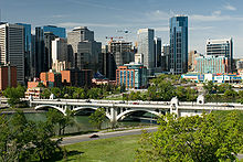
In the downtown section, Centre Street is lined by some of Calgary's landmark buildings, such as the Suncor Energy Centre (formerly Petro-Canada Centre), the Dragon City Mall
, Telus building, Hyatt Regncy hotel and Calgary Tower
. The Encana Bow tower is being built along Centre Street.
 The Centre Street Bridge
was built by the City of Calgary in 1916 over the Bow River
for $375,000 replacing a steel truss bridge
built by a land developer called the Centre Street Bridge Company Limited. It was designed by John F. Green, featured an upper and lower deck, and large cast concrete lions on four massive plinths, two at each end of the bridge.
It went through extensive restoration in 2001, when the bridge was closed for one year. The opening scene of the 2001 Steven Seagal
movie Exit Wounds
was filmed on the bridge during this closure.
bus routes serves Centre Street (as of May 2009, communities served are in parentheses):
Centre Street N continues at Stoney Trail and to the north Intersecting at:
Calgary
Calgary is a city in the Province of Alberta, Canada. It is located in the south of the province, in an area of foothills and prairie, approximately east of the front ranges of the Canadian Rockies...
, Alberta
Alberta
Alberta is a province of Canada. It had an estimated population of 3.7 million in 2010 making it the most populous of Canada's three prairie provinces...
.
The northern part (Centre Street North) extends from the Bow River
Bow River
The Bow River is a river in the Canadian province of Alberta. It is a tributary of the South Saskatchewan River, and is considered the headwater of the Nelson River....
to Bergen Road/Beddington Drive, after which it becomes a local arterial street before it becomes unavailable to private vehicular traffic north of Bergen Crescent (the road continues, but it is only accessible to Calgary Transit
Calgary Transit
Calgary Transit is the public transit service which is owned and operated by the city of Calgary, Alberta. In 2008, an estimated 95.3 million passengers boarded approximately 960 Calgary Transit vehicles , which thus provided 2.31 million hours of service .-History:What would eventually become...
and emergency vehicles). The road resumes immediately north of the "bus trap" at Beddington Trail, where it continues under the name Harvest Hills Boulevard. When the boulevard crosses Stoney Trail, the name reverts to Centre Street and the road continues north and exits the city limits. Centre Street North runs through the communities of Crescent Heights
Crescent Heights, Calgary
Crescent Heights is a neighbourhood in the northwest quadrant of Calgary, Alberta. It is located in the inner city, immediately north from Downtown...
, Tuxedo Park, Highland Park, Thorncliffe, Huntington Hills and Beddington Heights. The portion north of Stoney Trail passes through an undeveloped section of the city.
The southern portion, designated Centre Street South, begins at the Bow River and continues south though Chinatown, Calgary
Chinatown, Calgary
Calgary's Chinatown is the fourth largest in Canada after those in Vancouver,Toronto, and Montreal. The size of Calgary's Chinatown is indicative of the relatively high proportion of people of Asian descent living in the city....
and Downtown Calgary
Downtown Calgary
Downtown Calgary is a region of central Calgary, Alberta. It is not a single neighbourhood per se, but is actually a larger community containing three neighbourhoods and a number of districts....
before ending at 9th Avenue S., at the foot of the Calgary Tower
Calgary Tower
The Calgary Tower is a 191 metre free standing observation tower in Downtown Calgary, Alberta, Canada. Originally called the Husky Tower, it was conceived as a joint venture between Marathon Realty Company Limited and Husky Oil as part of an urban renewal plan and to celebrate Canada's centennial...
. Several non-contiguous sections of Centre Street appear sporadically south of this point, including between 10 Avenue S. and 18 Avenue S., a section of road that is also known as Volunteer Way; and as a commercial/industrial business road running south of 58 Avenue S. to Glenmore Trail, where it continues to the south as Fairmount Drive. In most of the southern part of Calgary, Macleod Trail forms the central line.
Centre Street (along with Harvest Hills Boulevard in the north and Macleod Trail in the south), defines the east and west halves of the city for the purposes of street addresses (i.e. NW, SW, NE, SE).
In the downtown section, Centre Street is lined by some of Calgary's landmark buildings, such as the Suncor Energy Centre (formerly Petro-Canada Centre), the Dragon City Mall
Dragon City Mall
Dragon City Mall is a shopping mall located in the Chinatown district, Downtown Calgary.The mall was originally an office building but was converted into a mall in the early 1990s.It contains Asian themed venues, varying from China, Japan, and Korea....
, Telus building, Hyatt Regncy hotel and Calgary Tower
Calgary Tower
The Calgary Tower is a 191 metre free standing observation tower in Downtown Calgary, Alberta, Canada. Originally called the Husky Tower, it was conceived as a joint venture between Marathon Realty Company Limited and Husky Oil as part of an urban renewal plan and to celebrate Canada's centennial...
. The Encana Bow tower is being built along Centre Street.
Centre Street Bridge
Centre Street Bridge (Calgary)
The Centre Street Bridge is a bridge in Calgary, Alberta, crossing the Bow River, along the Centre Street. The lower deck connects Riverfront Avenue in Chinatown with Memorial Drive, while the upper elevated deck crosses Memorial Drive as well, reaching into the community of Crescent...
was built by the City of Calgary in 1916 over the Bow River
Bow River
The Bow River is a river in the Canadian province of Alberta. It is a tributary of the South Saskatchewan River, and is considered the headwater of the Nelson River....
for $375,000 replacing a steel truss bridge
Truss bridge
A truss bridge is a bridge composed of connected elements which may be stressed from tension, compression, or sometimes both in response to dynamic loads. Truss bridges are one of the oldest types of modern bridges...
built by a land developer called the Centre Street Bridge Company Limited. It was designed by John F. Green, featured an upper and lower deck, and large cast concrete lions on four massive plinths, two at each end of the bridge.
It went through extensive restoration in 2001, when the bridge was closed for one year. The opening scene of the 2001 Steven Seagal
Steven Seagal
Steven Frederic Seagal is an American action film star, producer, writer, martial artist, guitarist and reserve deputy sheriff. A 7th-dan black belt in Aikido, Seagal began his adult life as an Aikido instructor in Japan...
movie Exit Wounds
Exit Wounds
Exit Wounds is a 2001 action film based on the book of the same name by John Westermann. The book takes place on Long Island, while the film is set in Detroit. The film was directed by Andrzej Bartkowiak, and stars Steven Seagal as an urban detective notorious for pushing the limits of the law in...
was filmed on the bridge during this closure.
Calgary Transit Bus Routes
The following Calgary TransitCalgary Transit
Calgary Transit is the public transit service which is owned and operated by the city of Calgary, Alberta. In 2008, an estimated 95.3 million passengers boarded approximately 960 Calgary Transit vehicles , which thus provided 2.31 million hours of service .-History:What would eventually become...
bus routes serves Centre Street (as of May 2009, communities served are in parentheses):
- Route 2 Killarney 17th Ave./Mount Pleasant (Beddington Heights, Crescent Heights)
- Route 3 Elbow Drive/Sandstone (Crescent Heights, Tuxedo Park, Highland Park, Thorncliffe, Huntington Hills, Beddington Heights)
- Route 4 Huntington (Huntington Hills)
- Route 5 North Haven (Huntington Hills)
- Route 17 Spruce Cliff/Renfrew (Crescent Heights)
- Route 20 Heritage/Northmount (Huntington Hills)
- Route 32 Sunridge/Huntington (Huntington Hills, Beddington Heights)
- Route 46 Beddington Heights (Beddington Heights, Huntington Hills)
- Route 62 Hidden Valley Express (Crescent Heights, Tuxedo Park, Highland Park, Thorncliffe, Huntington Hills)
- Route 64 MacEwan Express (Crescent Heights, Tuxedo Park, Highland Park, Thorncliffe, Huntington Hills)
- Route 86 Coventry Hills (Beddington Heights, Huntington Hills)
- Route 88 Harvest Hills (Beddington Heights, Huntington Hills)
- Route 109 Harvest Hills Express (Crescent Heights, Tuxedo Park, Highland Park, Thorncliffe, Huntington Hills, Beddington Heights)
- Route 114 Panorama Hills (Huntington Hills, Beddington Heights)
- Route 116 Coventry Hills Express (Crescent Heights, Tuxedo Park, Highland Park, Thorncliffe, Huntington Hills, Beddington Heights)
- Route 142 Panorama Hills Express (Crescent Heights, Tuxedo Park, Highland Park, Thorncliffe, Huntington Hills, Beddington Heights)
- Route 146 Beddington Heights (Beddington Heights, Huntington Hills)
- Route 301 North-West BRT (Crescent Heights, Tuxedo Park, Highland Park, Thorncliffe, Huntington Hills, Beddington Heights)
- Route 449 North Hill/MacEwan (Beddington Heights)
Route
Centre Street N| km | Intersection | Remarks | |
|---|---|---|---|
| 0 | 9 Avenue S | One way eastbound | |
| 0.1 | 8 Avenue S | Pedestrian mall, one way westbound when open to traffic | |
| 0.2 | 7 Avenue S | Transit mall, no access | |
| 0.3 | 6 Avenue S | One way westbound | |
| 0.4 | 5 Avenue S | One way eastbound | |
| 0.5 | 4 Avenue S | One way westbound | |
| 0.7 | 3 Avenue S | ||
| 0.8 | 2 Avenue S | ||
| 0.9 | Riverfront Avenue S | Overpass (no access), access to Centre Street Bridge lower deck | |
| 1.1 | Memorial Drive N | Overpass (no access), access to Centre Street Bridge lower deck | |
| 1.2 | Samis Road NE | Eastbound only | |
| 1.6 | 7 Avenue N | ||
| 1.7 | 8 Avenue N | ||
| 1.8 | 9 Avenue N | ||
| 1.9 | 10 Avenue N | ||
| 2.0 | 11 Avenue N | ||
| 2.1 | 12 Avenue N | ||
| 2.2 | 13 Avenue N | ||
| 2.3 | 14 Avenue NW | Westbound only | |
| 2.4 | 15 Avenue NW | Westbound only | |
| 2.5 | 16 Avenue N | Trans-Canada Highway (route 1) | |
| 2.6 | 17 Avenue N | ||
| 2.7 | 18 Avenue N | ||
| 2.8 | 19 Avenue N | ||
| 2.9 | 20 Avenue N | ||
| 3.0 | 21 Avenue N | ||
| 3.1 | 22 Avenue N | ||
| 3.2 | 23 Avenue N | ||
| 3.3 | 24 Avenue N | ||
| 3.4 | 25 Avenue N | ||
| 3.5 | 26 Avenue N | ||
| 3.6 | 27 Avenue N | ||
| 3.7 | 28 Avenue N | ||
| 3.8 | 29 Avenue N | ||
| 3.9 | 30 Avenue N | ||
| 4.0 | 31 Avenue N | ||
| 4.1 | 32 Avenue N | ||
| 4.3 | 34 Avenue N | ||
| 4.5 | 36 Avenue N | ||
| 4.7 | 38 Avenue N | ||
| 4.9 | 40 Avenue N | ||
| 5.0 | 41 Avenue N | ||
| 5.1 | 42 Avenue N | ||
| 5.2 | 43 Avenue N | ||
| 5.3 | 44 Avenue N | ||
| 5.6 | Laycock Drive N | ||
| 5.7 | McKnight Boulevard N | ||
| 5.9 | Thorncrest Road N | ||
| 6.0 | Centre Crescent NW | South leg, westbound only | |
| 6.1 | 54 Avenue N / Centre Crescent NW | ||
| 6.2 | 55 Avenue N | ||
| 6.5 | Northmount Drive NW / 56 Avenue NE | ||
| 6.7 | 59 Avenue N | ||
| 6.8 | 60 Avenue NE | ||
| 6.9 | Thistle Place NE | Turnaround | |
| 7.0 | Blackthorn Road N | ||
| 7.1 | Tache Avenue NW | Westbound only | |
| 7.3 | 64 Avenue N | ||
| 7.7 | 68 Avenue NE | Eastbound only | |
| 8.1 | 68 Avenue NW | Westbound only | |
| 8.3 | 4 Street NW / 72 Avenue NE | ||
| 8.9 | 78 Avenue N | ||
| 9.1 | Beddington Boulevard N | ||
| 9.6 | Bergen Road NW / Beddington Drive NE | ||
| 9.7 | Bergen Crescent NW | South leg | |
| 9.9 | Bergen Crescent NW | North leg, transit access north to Harvest Hills Boulevard N |
Centre Street N continues at Stoney Trail and to the north Intersecting at:
- Stoney Trail N
- 144 Avenue N
- 176 Avenue N