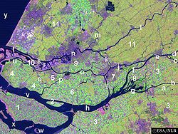
Botlek
Encyclopedia

Nieuwe Maas
The Nieuwe Maas distributary of the Rhine River, and a former distributary of the Maas River, in the Dutch province of South Holland. It runs from the confluence of the rivers Noord and Lek, and flows west through Rotterdam. It ends west of the city where it meets the Oude Maas , near Vlaardingen,...
river, part of the Rhine-Meuse
Meuse River
The Maas or Meuse is a major European river, rising in France and flowing through Belgium and the Netherlands before draining into the North Sea...
delta
River delta
A delta is a landform that is formed at the mouth of a river where that river flows into an ocean, sea, estuary, lake, reservoir, flat arid area, or another river. Deltas are formed from the deposition of the sediment carried by the river as the flow leaves the mouth of the river...
near the Dutch
Netherlands
The Netherlands is a constituent country of the Kingdom of the Netherlands, located mainly in North-West Europe and with several islands in the Caribbean. Mainland Netherlands borders the North Sea to the north and west, Belgium to the south, and Germany to the east, and shares maritime borders...
cities of Vlaardingen
Vlaardingen
Vlaardingen is a town in South Holland in the Netherlands. It is located on the north bank of the Nieuwe Maas/Nieuwe Waterweg river at the confluence with the Oude Maas...
and Spijkenisse
Spijkenisse
Spijkenisse is a town and municipality in the western Netherlands, in the province of South Holland. The municipality had a population of 74,482 in 2006, and covers an area of 30.23 km²...
in the province
Province
A province is a territorial unit, almost always an administrative division, within a country or state.-Etymology:The English word "province" is attested since about 1330 and derives from the 13th-century Old French "province," which itself comes from the Latin word "provincia," which referred to...
of Zuid-Holland. Specifically, it was the name of the strait
Strait
A strait or straits is a narrow, typically navigable channel of water that connects two larger, navigable bodies of water. It most commonly refers to a channel of water that lies between two land masses, but it may also refer to a navigable channel through a body of water that is otherwise not...
that separated the island
Island
An island or isle is any piece of sub-continental land that is surrounded by water. Very small islands such as emergent land features on atolls can be called islets, cays or keys. An island in a river or lake may be called an eyot , or holm...
of Rozenburg
Rozenburg
Rozenburg is a town and former municipality in the western Netherlands, in the province of South Holland. The municipality had a population of 13,173 in 2004, and covers an area of 6.50 km² . It was the second-smallest municipality in the Netherlands in area...
from the sand bar
Bar (landform)
A shoal, sandbar , or gravelbar is a somewhat linear landform within or extending into a body of water, typically composed of sand, silt or small pebbles. A spit or sandspit is a type of shoal...
of Welplaat. The strait itself was merely the continuation of the Nieuwe Maas
Nieuwe Maas
The Nieuwe Maas distributary of the Rhine River, and a former distributary of the Maas River, in the Dutch province of South Holland. It runs from the confluence of the rivers Noord and Lek, and flows west through Rotterdam. It ends west of the city where it meets the Oude Maas , near Vlaardingen,...
, and the stretch of the river south of Rozenburg continued to be called Nieuwe Maas
Nieuwe Maas
The Nieuwe Maas distributary of the Rhine River, and a former distributary of the Maas River, in the Dutch province of South Holland. It runs from the confluence of the rivers Noord and Lek, and flows west through Rotterdam. It ends west of the city where it meets the Oude Maas , near Vlaardingen,...
until the confluence with het Scheur formed the Brielse Maas
Brielse meer
The Brielse Meer is a long, narrow lake between the Dutch estuary islands of Voorne and Rozenburg in the province of Zuid-Holland....
estuary
Estuary
An estuary is a partly enclosed coastal body of water with one or more rivers or streams flowing into it, and with a free connection to the open sea....
.
Major waterway
Waterway
A waterway is any navigable body of water. Waterways can include rivers, lakes, seas, oceans, and canals. In order for a waterway to be navigable, it must meet several criteria:...
regulation works were carried out in the Netherlands in the 19th and 20th centuries to improve water management and stop the delta from silting up; the Botlek was dammed off at its southern end (connecting Rozenburg and Welplaat) and remodelled into one of the largest of the Rotterdam
Rotterdam
Rotterdam is the second-largest city in the Netherlands and one of the largest ports in the world. Starting as a dam on the Rotte river, Rotterdam has grown into a major international commercial centre...
seaports (see also Europoort
Europoort
Europoort is an area of the Port of Rotterdam and the adjoining industrial area in the Netherlands. Being situated at the mouth of the rivers Rhine and Meuse with the hinterland consisting of the Netherlands, Germany, Belgium and partly France, Europoort is by certain measurements the world's...
).

