
Boeing Creek
Encyclopedia
Boeing Creek is a stream
in the U.S. state
of Washington, located in the city of Shoreline
, just north of Seattle. It is about 1.6 miles (2.6 km) long and empties into Puget Sound
. The creek is heavily modified along its course, and in many places has been diverted into culvert
s. The watershed of Boeing Creek is about 11.2 mi2 in size, with two main tributaries aside from the mainstem
. The creek takes its name from William Boeing
, who built a mansion along the creek in 1913. Despite the river modifications and stormwater pollution, the creek supports a variety of riparian habitats, native animals and fishes.
s at the intersection of Greenwood Ave and Carlyle Hall Road, which is considered its source, 47.7506531°N 122.3576292 °W. The creek flows along the Shoreline Community College
campus, through Boeing Creek Park (the northern part of Shoreview Park). At the west end of the park the creek empties into Hidden Lake, 47.7514864°N 122.3712408°W. Boeing Creek exits Hidden Lake through a culvert under Innis Arden Way and flows west through a ravine and under BNSF's
railroad tracks before emptying into Puget Sound.
There are two main tributary forks of Boeing Creek. The northern fork emerges from a culvert in Boeing Creek Park. Its water comes from drainage pipes beneath 6th Avenue. This fork joins the main stem in Boeing Creek Park. Another tributary fork rises in the neighborhoods of Shoreview Hills and The Highlands and flows north to join Boeing Creek below Hidden Lake.
The lowermost portion of Boeing Creek flows between the neighborhoods of The Highlands and Innis Arden. The Highlands is an exclusive gated community designed by the Olmsted Brothers
in 1909. This portion of the creek is not accessible to the public.
During high flow events, additional water from pipes beneath 175th Street enters Boeing Creek Park, flowing into a stormwater detention basin
, then into the northern fork of Boeing Creek.
operated six stream gages on Boeing Creek during the 1990s. Gage 04j, called "Boeing Creek off Beach DR", was the furthest downstream at approximately river mile
0.4. It operated from August 7, 1991 to March 19, 1993. The maximum daily discharge measured was 16.86 cuft/s. The minimum daily discharge was 1.06. The mean discharge over the life of the gage was 2.7 cuft/s.
is 11.74 square miles (30.4 km²) large and includes 3.4 miles (5.5 km) of Puget Sound shoreline. The watershed is almost entirely within the city of Shoreline, reaching north nearly to the Snohomish County
line. Its southern extent reaches slightly into the city of Seattle. Boeing Creek's watershed borders, to the west, the watersheds of McAleer Creek, Thornton Creek
, and Lyons Creek. King County maps Boeing Creek's watershed slightly differently. According to King County the watershed is completely contained within the City of Shoreline.
, founder of the Boeing
company, had a mansion built in The Highlands neighborhood, along Boeing Creek. He lived by himself until 1921, when he married and started a family. In time the creek came to be named after Boeing. Earlier names included Hidden Creek and Hidden Lake Creek. The senior water right
s on the stream, those of William Boeing and the Seattle Golf and Country Club, call it "unnamed stream". The official USGS name, Boeing Creek, was entered into the GNIS database on September 10, 1979. Boeing owned much of the lower creek, including today's Shoreview and Boeing Creek Parks. He used the land primarily as a hunting retreat and had a small dam made, creating Hidden Lake which he used as a private fishing pond. In the 1930s Boeing plat
ted and logged
400 acres (1.6 km²) north of Boeing Creek and sold the land to developers. The Innis Arden neighborhood began to be developed on this land after World War II. The land that today is Boeing Creek Park was partially logged, leaving a number of large mature conifers, some over 200 feet (61 m) tall. It is unclear why the area was only partially logged. The steep slopes may have made it too costly to fully log.
Much of Boeing Creek's upper course, to Hidden Lake, is within Boeing Creek Park, the northern part of Shoreview Park. Run by the City of Shoreline, these parks together span 88 acres (356,123.7 m²). William Boeing transferred the land that is now Shoreview Park to the Shoreline School District. In the mid-1970s land was cleared south of Hidden Lake for the construction of Shoreview High School. Funding failed and the school was never built. The cleared and terraced site has become infested with invasive species such as Scotch broom
and Himalayan blackberry
. In 1977 King County purchased the land from the Shoreline School District and established Shoreview Park. The City of Shoreline assumed ownership of Shoreview Park and adjoining Boeing Creek Park in 1997. Trails in these parks allow access to the middle portion of Boeing Creek. A few trails are official and maintained, including one that runs along the creek to Hidden Lake. There are a large number of "social trails" as well, which often climb steep, unstable slopes, increasing erosion and overall stream degradation. The lower portion of the creek, below Hidden Lake, is not accessible to the general public. Innis Arden does maintain a private trail for their residents that starts just below Hidden Lake and goes to the creeks end.
s, gravel
s, and silt
s created during the last glacial period. Materials present include subglacial till
s made up of silt, sand, and gravel particles; advance outwash
deposits, made up of well-sorted sands and gravels; and transitional beds, made up of compacted clay
, silt, and sometimes sand.
use that has been documented in Boeing Creek include chinook salmon
(Oncorhynchus tshawytscha), chum salmon
(Oncorhynchus keta), coho salmon
(Oncorhynchus kisutch), and sea run cutthroat trout
(Oncorhynchus clarki). A study done in 1994 found juvenile coho salmon in the lower portion of Boeing Creek, below the Seattle Golf Course Dam. The same study found cutthroat trout below in most of Boeing Creek, up to the King County M1 R/D pond, near the creek's source. The Salmon Watchers Program have observed a site on river mile
0.1 of Boeing Creek since 2000. Coho and chum salmon are commonly seen, with fish counts ranging up to 160 chum salmon in 2003 and 89 coho salmon in 2001. Two chinook salmon were observed in 2000.
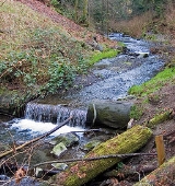
Fish populations are hindered by two storm water detention systems: the M-1 Dam (or "Boeing Creek Detention Facility"), an in-stream retention device on the main fork, and the Retention-Detention Ponds, an off-channel system in Boeing Creek Park. Three other structures influence stream ecology: Hidden Lake and its associated dam; an artificial waterfall, about ten feet high, constructed from concrete, just downstream from Innis Arden Way; and the "Seattle Country Club Golf Course Dam", a metal dam and pump station about 200 meters downstream of Innis Arden Way, which forms of reservoir that supplies the Seattle Country Club golf course with irrigation water. None of the dams provide fish passage
and therefore present a total barrier, limiting stream use by anadromous
species to the lower third of the creek.
forest along Boeing Creek in Boeing Creek Park is an intact native ecosystem, mostly free of invasive species. There are a number of mature conifers that escaped being logged, including 200 feet (61 m) tall Douglas-fir
and Western White Pine
trees. Salmonberry shrubs are common along the creek. In some areas invasive species
such as Scotch broom
, Himalayan blackberry
, English ivy
, and Herb Robert are present. The native species
of Sword fern
and Stinging nettle
are common.
In the 1960s a Sears
mall complex was built at Aurora Avenue
and 160th Street, covering Boeing Creek's wetland
headwaters
. This and other urban development placed about 2 miles (3.2 km) of what had been upper Boeing Creek into a patchwork of pipes, most of which are on private property. Within this area there is one 400 feet (121.9 m) segment that flows free from pipes, located in Darnell Park. However a lack of detention facilities and an undersized pipe causes flooding in the vicinity of Darnell Park and contributes to erosive flows downstream. The City of Shoreline is planning on improving the drainage and reducing downstream erosion by building a detention basin and replacing the pipe.
The creek's watershed was heavily urbanized
after World War II
, altering the runoff
and discharge
patterns. Increased runoff into Boeing Creek during rainy weather has caused more intense erosion
and sediment transport
, leading to the build-up of sediment
in Hidden Lake. In the 1970s heavy rains flushed enough sediment down the creek to completely fill Hidden Lake, which became a meadow. Subsequently, King County Surface Water Division began efforts to control stormwater
runoff
in Boeing Creek's watershed. In 1996 dredging work restored Hidden Lake. On January 1, 1997, a winter storm created a large sinkhole
which ruptured sewer lines on 175th Street, resulting in the Hidden Lake being filled with sediment again. The lake was dredged and restored again. The city of Shoreline budgets money for dredging Hidden Lake as needed and continues to seek a long-term solution to the problems of increased storm surge runoff, erosion, and sedimentation.
King County built a stormwater control system in Boeing Creek Park. A large detention basin
stores water during storms, reducing the creek's flood risk. The detention basin is augmented by an underground storage pipe designed to temporarily store up to 500,000 gallons of wastewater during large storms. This storage pipe is located under the detention basin in Boeing Creek Park. The pipe is 12 feet (3.7 m) in diameter and about 640 feet (195.1 m) long. Completed in 2007 by King County Public Works, the pipe's purpose is to help keep wastewater within the sewer system and reduce overflows into Puget Sound. The pipe conveys wastewater to the Hidden Lake Pump Station. At the same time the Hidden Lake Pump Station, located on Hidden Lake, was replaced in order to increase capacity. The old pump station lacked capacity, resulting in about three overflows into Puget Sound per year. Another related wastewater projet is the Boeing Creek Trunk Sewer Replacement. A major wastewater conveyance pipe, the Boeing Creek Trunk (BCT) was under capacity and had deteriorated with age. During heavy rain storms wastewater sometimes overflowed from manholes and into Puget Sound. These projects were all part of the Hidden Lake Pump Station replacement and sewer improvement project. Construction of this overall project began in 2006. The underground storage pipe in Boeing Creek Park was finished in 2007, Boeing Creek Trunk in 2008, and the Hidden Lake Pump Station in 2009. All of these wastewater systems are located very close to Boeing Creek, although the Boeing Creek Trunk extends north out of the creek's watershed. The City of Shoreline is planning additional stormwater management projects to reduce flooding and improve Boeing Creek's hydrology. Construction of the Pan Terra Pond and Pump Improvement Project began in 2009.
Stream
A stream is a body of water with a current, confined within a bed and stream banks. Depending on its locale or certain characteristics, a stream may be referred to as a branch, brook, beck, burn, creek, "crick", gill , kill, lick, rill, river, syke, bayou, rivulet, streamage, wash, run or...
in the U.S. state
U.S. state
A U.S. state is any one of the 50 federated states of the United States of America that share sovereignty with the federal government. Because of this shared sovereignty, an American is a citizen both of the federal entity and of his or her state of domicile. Four states use the official title of...
of Washington, located in the city of Shoreline
Shoreline, Washington
Shoreline is a city in King County, Washington, United States, north of Downtown Seattle bordering the northern Seattle city limits. As of the 2010 census, the population was 53,007, making it the 19th largest city in the state of Washington....
, just north of Seattle. It is about 1.6 miles (2.6 km) long and empties into Puget Sound
Puget Sound
Puget Sound is a sound in the U.S. state of Washington. It is a complex estuarine system of interconnected marine waterways and basins, with one major and one minor connection to the Strait of Juan de Fuca and the Pacific Ocean — Admiralty Inlet being the major connection and...
. The creek is heavily modified along its course, and in many places has been diverted into culvert
Culvert
A culvert is a device used to channel water. It may be used to allow water to pass underneath a road, railway, or embankment. Culverts can be made of many different materials; steel, polyvinyl chloride and concrete are the most common...
s. The watershed of Boeing Creek is about 11.2 mi2 in size, with two main tributaries aside from the mainstem
Mainstem (hydrology)
In relation to hydrology, a main stem is "the primary downstream segment of a river, as contrasted to its tributaries". Another common term for the main stem, the final large channel of a riverine system, is the trunk. Water enters the main stem from the river's drainage basin, the land area...
. The creek takes its name from William Boeing
William Boeing
William Edward Boeing was an American aviation pioneer who founded The Boeing Company.-Biography:Boeing was born to a wealthy German mining engineer named Wilhelm Böing who had made a fortune and who had a sideline as a timber merchant...
, who built a mansion along the creek in 1913. Despite the river modifications and stormwater pollution, the creek supports a variety of riparian habitats, native animals and fishes.
Course
Boeing Creek's original headwaters have been placed into underground pipes. The creek's main stem emerges from storm drain culvertCulvert
A culvert is a device used to channel water. It may be used to allow water to pass underneath a road, railway, or embankment. Culverts can be made of many different materials; steel, polyvinyl chloride and concrete are the most common...
s at the intersection of Greenwood Ave and Carlyle Hall Road, which is considered its source, 47.7506531°N 122.3576292 °W. The creek flows along the Shoreline Community College
Shoreline Community College
Shoreline Community College is a community college in Shoreline, north of Seattle, Washington. It is located in a residential area east of Shoreview Park. The college contains 83 acres and continuously serves 12,000 full and part-time students....
campus, through Boeing Creek Park (the northern part of Shoreview Park). At the west end of the park the creek empties into Hidden Lake, 47.7514864°N 122.3712408°W. Boeing Creek exits Hidden Lake through a culvert under Innis Arden Way and flows west through a ravine and under BNSF's
BNSF Railway
The BNSF Railway is a wholly owned subsidiary of Berkshire Hathaway Inc., and is headquartered in Fort Worth, Texas. It is one of seven North American Class I railroads and the second largest freight railroad network in North America, second only to the Union Pacific Railroad, its primary...
railroad tracks before emptying into Puget Sound.
There are two main tributary forks of Boeing Creek. The northern fork emerges from a culvert in Boeing Creek Park. Its water comes from drainage pipes beneath 6th Avenue. This fork joins the main stem in Boeing Creek Park. Another tributary fork rises in the neighborhoods of Shoreview Hills and The Highlands and flows north to join Boeing Creek below Hidden Lake.
The lowermost portion of Boeing Creek flows between the neighborhoods of The Highlands and Innis Arden. The Highlands is an exclusive gated community designed by the Olmsted Brothers
Olmsted Brothers
The Olmsted Brothers company was an influential landscape design firm in the United States, formed in 1898 by stepbrothers John Charles Olmsted and Frederick Law Olmsted, Jr. .-History:...
in 1909. This portion of the creek is not accessible to the public.
During high flow events, additional water from pipes beneath 175th Street enters Boeing Creek Park, flowing into a stormwater detention basin
Detention basin
A detention basin is a stormwater management facility installed on, or adjacent to, tributaries of rivers, streams, lakes or bays that is designed to protect against flooding and, in some cases, downstream erosion by storing water for a limited period of a time. These basins are also called "dry...
, then into the northern fork of Boeing Creek.
Discharge
King CountyKing County, Washington
King County is a county located in the U.S. state of Washington. The population in the 2010 census was 1,931,249. King is the most populous county in Washington, and the 14th most populous in the United States....
operated six stream gages on Boeing Creek during the 1990s. Gage 04j, called "Boeing Creek off Beach DR", was the furthest downstream at approximately river mile
River mile
In the United States, a River mile is a measure of distance in miles along a river from its mouth. River mile numbers begin at zero and increase further upstream. The corresponding metric unit using kilometers is the River kilometer...
0.4. It operated from August 7, 1991 to March 19, 1993. The maximum daily discharge measured was 16.86 cuft/s. The minimum daily discharge was 1.06. The mean discharge over the life of the gage was 2.7 cuft/s.
Watershed
According to Rich Ellison, Boeing Creek's watershedDrainage basin
A drainage basin is an extent or an area of land where surface water from rain and melting snow or ice converges to a single point, usually the exit of the basin, where the waters join another waterbody, such as a river, lake, reservoir, estuary, wetland, sea, or ocean...
is 11.74 square miles (30.4 km²) large and includes 3.4 miles (5.5 km) of Puget Sound shoreline. The watershed is almost entirely within the city of Shoreline, reaching north nearly to the Snohomish County
Snohomish County, Washington
Snohomish County is a county located in the U.S. state of Washington. It is named after the Snohomish tribe. Since 2000, the county's population has grown from 606,024 to 713,335 residents , making it one of the fastest-growing in the state, ranking third in overall population after King and...
line. Its southern extent reaches slightly into the city of Seattle. Boeing Creek's watershed borders, to the west, the watersheds of McAleer Creek, Thornton Creek
Thornton Creek
Thornton Creek is 18 miles of urban creeks and tributaries from southeast Shoreline through northeast Seattle to Lake Washington. The creek is the largest watershed in Seattle, draining a region of relatively dense biodiversity for an urban setting, home to frogs, newts, ducks, other birds, and...
, and Lyons Creek. King County maps Boeing Creek's watershed slightly differently. According to King County the watershed is completely contained within the City of Shoreline.
History
In 1913 William BoeingWilliam Boeing
William Edward Boeing was an American aviation pioneer who founded The Boeing Company.-Biography:Boeing was born to a wealthy German mining engineer named Wilhelm Böing who had made a fortune and who had a sideline as a timber merchant...
, founder of the Boeing
Boeing
The Boeing Company is an American multinational aerospace and defense corporation, founded in 1916 by William E. Boeing in Seattle, Washington. Boeing has expanded over the years, merging with McDonnell Douglas in 1997. Boeing Corporate headquarters has been in Chicago, Illinois since 2001...
company, had a mansion built in The Highlands neighborhood, along Boeing Creek. He lived by himself until 1921, when he married and started a family. In time the creek came to be named after Boeing. Earlier names included Hidden Creek and Hidden Lake Creek. The senior water right
Water right
Water right in water law refers to the right of a user to use water from a water source, e.g., a river, stream, pond or source of groundwater. In areas with plentiful water and few users, such systems are generally not complicated or contentious...
s on the stream, those of William Boeing and the Seattle Golf and Country Club, call it "unnamed stream". The official USGS name, Boeing Creek, was entered into the GNIS database on September 10, 1979. Boeing owned much of the lower creek, including today's Shoreview and Boeing Creek Parks. He used the land primarily as a hunting retreat and had a small dam made, creating Hidden Lake which he used as a private fishing pond. In the 1930s Boeing plat
Plat
A plat in the U.S. is a map, drawn to scale, showing the divisions of a piece of land. Other English-speaking countries generally call such documents a cadastral map or plan....
ted and logged
Logging
Logging is the cutting, skidding, on-site processing, and loading of trees or logs onto trucks.In forestry, the term logging is sometimes used in a narrow sense concerning the logistics of moving wood from the stump to somewhere outside the forest, usually a sawmill or a lumber yard...
400 acres (1.6 km²) north of Boeing Creek and sold the land to developers. The Innis Arden neighborhood began to be developed on this land after World War II. The land that today is Boeing Creek Park was partially logged, leaving a number of large mature conifers, some over 200 feet (61 m) tall. It is unclear why the area was only partially logged. The steep slopes may have made it too costly to fully log.
Much of Boeing Creek's upper course, to Hidden Lake, is within Boeing Creek Park, the northern part of Shoreview Park. Run by the City of Shoreline, these parks together span 88 acres (356,123.7 m²). William Boeing transferred the land that is now Shoreview Park to the Shoreline School District. In the mid-1970s land was cleared south of Hidden Lake for the construction of Shoreview High School. Funding failed and the school was never built. The cleared and terraced site has become infested with invasive species such as Scotch broom
Cytisus scoparius
Cytisus scoparius, the Common Broom and Scotch Broom, syn. Sarothamnus scoparius, is a perennial leguminous shrub native to western and central Europe,....
and Himalayan blackberry
Rubus armeniacus
Rubus armeniacus, Armenian Blackberry or Himalayan Blackberry, is a species of Rubus in the blackberry group Rubus subgenus Rubus series Discolores Focke. It is native to Armenia in southwest Asia, and widely naturalised elsewhere...
. In 1977 King County purchased the land from the Shoreline School District and established Shoreview Park. The City of Shoreline assumed ownership of Shoreview Park and adjoining Boeing Creek Park in 1997. Trails in these parks allow access to the middle portion of Boeing Creek. A few trails are official and maintained, including one that runs along the creek to Hidden Lake. There are a large number of "social trails" as well, which often climb steep, unstable slopes, increasing erosion and overall stream degradation. The lower portion of the creek, below Hidden Lake, is not accessible to the general public. Innis Arden does maintain a private trail for their residents that starts just below Hidden Lake and goes to the creeks end.
Geology
The geology of the Boeing Creek's watershed is dominated by sandSand
Sand is a naturally occurring granular material composed of finely divided rock and mineral particles.The composition of sand is highly variable, depending on the local rock sources and conditions, but the most common constituent of sand in inland continental settings and non-tropical coastal...
s, gravel
Gravel
Gravel is composed of unconsolidated rock fragments that have a general particle size range and include size classes from granule- to boulder-sized fragments. Gravel can be sub-categorized into granule and cobble...
s, and silt
Silt
Silt is granular material of a size somewhere between sand and clay whose mineral origin is quartz and feldspar. Silt may occur as a soil or as suspended sediment in a surface water body...
s created during the last glacial period. Materials present include subglacial till
Till
thumb|right|Closeup of glacial till. Note that the larger grains in the till are completely surrounded by the matrix of finer material , and this characteristic, known as matrix support, is diagnostic of till....
s made up of silt, sand, and gravel particles; advance outwash
Sandur
A sandur is a glacial outwash plain formed of sediments deposited by meltwater at the terminus of a glacier.- Formation :Sandar are found in glaciated areas, such as Svalbard, Kerguelen Islands, and Iceland...
deposits, made up of well-sorted sands and gravels; and transitional beds, made up of compacted clay
Clay
Clay is a general term including many combinations of one or more clay minerals with traces of metal oxides and organic matter. Geologic clay deposits are mostly composed of phyllosilicate minerals containing variable amounts of water trapped in the mineral structure.- Formation :Clay minerals...
, silt, and sometimes sand.
Fish
SalmonidSalmonidae
Salmonidae is a family of ray-finned fish, the only living family currently placed in the order Salmoniformes. It includes salmon, trout, chars, freshwater whitefishes and graylings...
use that has been documented in Boeing Creek include chinook salmon
Chinook salmon
The Chinook salmon, Oncorhynchus tshawytscha, is the largest species in the pacific salmon family. Other commonly used names for the species include King salmon, Quinnat salmon, Spring salmon and Tyee salmon...
(Oncorhynchus tshawytscha), chum salmon
Chum salmon
The chum salmon, Oncorhynchus keta, is a species of anadromous fish in the salmon family. It is a Pacific salmon, and may also be known as dog salmon or Keta salmon, and is often marketed under the name Silverbrite salmon...
(Oncorhynchus keta), coho salmon
Coho salmon
The Coho salmon, Oncorhynchus kisutch, is a species of anadromous fish in the salmon family. Coho salmon are also known as silver salmon or "silvers". It is the state animal of Chiba, Japan.-Description:...
(Oncorhynchus kisutch), and sea run cutthroat trout
Cutthroat trout
The cutthroat trout is a species of freshwater fish in the salmon family of order Salmoniformes. It is one of the many fish species colloquially known as trout...
(Oncorhynchus clarki). A study done in 1994 found juvenile coho salmon in the lower portion of Boeing Creek, below the Seattle Golf Course Dam. The same study found cutthroat trout below in most of Boeing Creek, up to the King County M1 R/D pond, near the creek's source. The Salmon Watchers Program have observed a site on river mile
River mile
In the United States, a River mile is a measure of distance in miles along a river from its mouth. River mile numbers begin at zero and increase further upstream. The corresponding metric unit using kilometers is the River kilometer...
0.1 of Boeing Creek since 2000. Coho and chum salmon are commonly seen, with fish counts ranging up to 160 chum salmon in 2003 and 89 coho salmon in 2001. Two chinook salmon were observed in 2000.
Fish populations are hindered by two storm water detention systems: the M-1 Dam (or "Boeing Creek Detention Facility"), an in-stream retention device on the main fork, and the Retention-Detention Ponds, an off-channel system in Boeing Creek Park. Three other structures influence stream ecology: Hidden Lake and its associated dam; an artificial waterfall, about ten feet high, constructed from concrete, just downstream from Innis Arden Way; and the "Seattle Country Club Golf Course Dam", a metal dam and pump station about 200 meters downstream of Innis Arden Way, which forms of reservoir that supplies the Seattle Country Club golf course with irrigation water. None of the dams provide fish passage
Fish ladder
A fish ladder, also known as a fishway, fish pass or fish steps, is a structure on or around artificial barriers to facilitate diadromous fishes' natural migration. Most fishways enable fish to pass around the barriers by swimming and leaping up a series of relatively low steps into the waters on...
and therefore present a total barrier, limiting stream use by anadromous
Fish migration
Many types of fish migrate on a regular basis, on time scales ranging from daily to annually or longer, and over distances ranging from a few metres to thousands of kilometres...
species to the lower third of the creek.
Vegetation
The riparianRiparian zone
A riparian zone or riparian area is the interface between land and a river or stream. Riparian is also the proper nomenclature for one of the fifteen terrestrial biomes of the earth. Plant habitats and communities along the river margins and banks are called riparian vegetation, characterized by...
forest along Boeing Creek in Boeing Creek Park is an intact native ecosystem, mostly free of invasive species. There are a number of mature conifers that escaped being logged, including 200 feet (61 m) tall Douglas-fir
Douglas-fir
Douglas-fir is one of the English common names for evergreen coniferous trees of the genus Pseudotsuga in the family Pinaceae. Other common names include Douglas tree, and Oregon pine. There are five species, two in western North America, one in Mexico, and two in eastern Asia...
and Western White Pine
Western White Pine
Western White Pine, Pinus monticola in the family Pinaceae, is a species of pine that occurs in the mountains of the western United States and Canada, specifically the Sierra Nevada, the Cascade Range, the Coast Range, and the northern Rocky Mountains. The tree extends down to sea level in many...
trees. Salmonberry shrubs are common along the creek. In some areas invasive species
Invasive species
"Invasive species", or invasive exotics, is a nomenclature term and categorization phrase used for flora and fauna, and for specific restoration-preservation processes in native habitats, with several definitions....
such as Scotch broom
Cytisus scoparius
Cytisus scoparius, the Common Broom and Scotch Broom, syn. Sarothamnus scoparius, is a perennial leguminous shrub native to western and central Europe,....
, Himalayan blackberry
Rubus armeniacus
Rubus armeniacus, Armenian Blackberry or Himalayan Blackberry, is a species of Rubus in the blackberry group Rubus subgenus Rubus series Discolores Focke. It is native to Armenia in southwest Asia, and widely naturalised elsewhere...
, English ivy
Hedera helix
Hedera helix is a species of ivy native to most of Europe and western Asia. It is labeled as an invasive species in a number of areas where it has been introduced.-Description:...
, and Herb Robert are present. The native species
Indigenous (ecology)
In biogeography, a species is defined as native to a given region or ecosystem if its presence in that region is the result of only natural processes, with no human intervention. Every natural organism has its own natural range of distribution in which it is regarded as native...
of Sword fern
Polystichum munitum
Polystichum munitum is an evergreen fern native to western North America, where it is one of the most abundant ferns occurring along the Pacific coast from southeast Alaska south to southern California, and also inland east to southeastern British Columbia, northern Idaho and western Montana, with...
and Stinging nettle
Stinging nettle
Stinging nettle or common nettle, Urtica dioica, is a herbaceous perennial flowering plant, native to Europe, Asia, northern Africa, and North America, and is the best-known member of the nettle genus Urtica...
are common.
Modifications
Early modifications of Boeing Creek include the logging of the creek's watershed, the creation of Hidden Lake, and the construction of the Seattle Country Club Golf Course Dam. The creek's mouth was crossed by railway tracks, today owned by BNSF, running along the edge of Puget Sound.In the 1960s a Sears
Sears, Roebuck and Company
Sears, officially named Sears, Roebuck and Co., is an American chain of department stores which was founded by Richard Warren Sears and Alvah Curtis Roebuck in the late 19th century...
mall complex was built at Aurora Avenue
Washington State Route 99
State Route 99, abbreviated SR 99, commonly called Highway 99, is a numbered state highway in the U.S. state of Washington extending just under from Fife in the south to Everett in the north, with a gap in Tukwila.-Southern division:...
and 160th Street, covering Boeing Creek's wetland
Wetland
A wetland is an area of land whose soil is saturated with water either permanently or seasonally. Wetlands are categorised by their characteristic vegetation, which is adapted to these unique soil conditions....
headwaters
Source (river or stream)
The source or headwaters of a river or stream is the place from which the water in the river or stream originates.-Definition:There is no universally agreed upon definition for determining a stream's source...
. This and other urban development placed about 2 miles (3.2 km) of what had been upper Boeing Creek into a patchwork of pipes, most of which are on private property. Within this area there is one 400 feet (121.9 m) segment that flows free from pipes, located in Darnell Park. However a lack of detention facilities and an undersized pipe causes flooding in the vicinity of Darnell Park and contributes to erosive flows downstream. The City of Shoreline is planning on improving the drainage and reducing downstream erosion by building a detention basin and replacing the pipe.
The creek's watershed was heavily urbanized
Urbanization
Urbanization, urbanisation or urban drift is the physical growth of urban areas as a result of global change. The United Nations projected that half of the world's population would live in urban areas at the end of 2008....
after World War II
World War II
World War II, or the Second World War , was a global conflict lasting from 1939 to 1945, involving most of the world's nations—including all of the great powers—eventually forming two opposing military alliances: the Allies and the Axis...
, altering the runoff
Surface runoff
Surface runoff is the water flow that occurs when soil is infiltrated to full capacity and excess water from rain, meltwater, or other sources flows over the land. This is a major component of the water cycle. Runoff that occurs on surfaces before reaching a channel is also called a nonpoint source...
and discharge
Discharge (hydrology)
In hydrology, discharge is the volume rate of water flow, including any suspended solids , dissolved chemical species and/or biologic material , which is transported through a given cross-sectional area...
patterns. Increased runoff into Boeing Creek during rainy weather has caused more intense erosion
Erosion
Erosion is when materials are removed from the surface and changed into something else. It only works by hydraulic actions and transport of solids in the natural environment, and leads to the deposition of these materials elsewhere...
and sediment transport
Sediment transport
Sediment transport is the movement of solid particles , typically due to a combination of the force of gravity acting on the sediment, and/or the movement of the fluid in which the sediment is entrained...
, leading to the build-up of sediment
Sediment
Sediment is naturally occurring material that is broken down by processes of weathering and erosion, and is subsequently transported by the action of fluids such as wind, water, or ice, and/or by the force of gravity acting on the particle itself....
in Hidden Lake. In the 1970s heavy rains flushed enough sediment down the creek to completely fill Hidden Lake, which became a meadow. Subsequently, King County Surface Water Division began efforts to control stormwater
Stormwater
Stormwater is water that originates during precipitation events. It may also be used to apply to water that originates with snowmelt that enters the stormwater system...
runoff
Surface runoff
Surface runoff is the water flow that occurs when soil is infiltrated to full capacity and excess water from rain, meltwater, or other sources flows over the land. This is a major component of the water cycle. Runoff that occurs on surfaces before reaching a channel is also called a nonpoint source...
in Boeing Creek's watershed. In 1996 dredging work restored Hidden Lake. On January 1, 1997, a winter storm created a large sinkhole
Sinkhole
A sinkhole, also known as a sink, shake hole, swallow hole, swallet, doline or cenote, is a natural depression or hole in the Earth's surface caused by karst processes — the chemical dissolution of carbonate rocks or suffosion processes for example in sandstone...
which ruptured sewer lines on 175th Street, resulting in the Hidden Lake being filled with sediment again. The lake was dredged and restored again. The city of Shoreline budgets money for dredging Hidden Lake as needed and continues to seek a long-term solution to the problems of increased storm surge runoff, erosion, and sedimentation.
King County built a stormwater control system in Boeing Creek Park. A large detention basin
Detention basin
A detention basin is a stormwater management facility installed on, or adjacent to, tributaries of rivers, streams, lakes or bays that is designed to protect against flooding and, in some cases, downstream erosion by storing water for a limited period of a time. These basins are also called "dry...
stores water during storms, reducing the creek's flood risk. The detention basin is augmented by an underground storage pipe designed to temporarily store up to 500,000 gallons of wastewater during large storms. This storage pipe is located under the detention basin in Boeing Creek Park. The pipe is 12 feet (3.7 m) in diameter and about 640 feet (195.1 m) long. Completed in 2007 by King County Public Works, the pipe's purpose is to help keep wastewater within the sewer system and reduce overflows into Puget Sound. The pipe conveys wastewater to the Hidden Lake Pump Station. At the same time the Hidden Lake Pump Station, located on Hidden Lake, was replaced in order to increase capacity. The old pump station lacked capacity, resulting in about three overflows into Puget Sound per year. Another related wastewater projet is the Boeing Creek Trunk Sewer Replacement. A major wastewater conveyance pipe, the Boeing Creek Trunk (BCT) was under capacity and had deteriorated with age. During heavy rain storms wastewater sometimes overflowed from manholes and into Puget Sound. These projects were all part of the Hidden Lake Pump Station replacement and sewer improvement project. Construction of this overall project began in 2006. The underground storage pipe in Boeing Creek Park was finished in 2007, Boeing Creek Trunk in 2008, and the Hidden Lake Pump Station in 2009. All of these wastewater systems are located very close to Boeing Creek, although the Boeing Creek Trunk extends north out of the creek's watershed. The City of Shoreline is planning additional stormwater management projects to reduce flooding and improve Boeing Creek's hydrology. Construction of the Pan Terra Pond and Pump Improvement Project began in 2009.
External links
- Shoreline Aerial Photos, Boeing Creek, Washington State Department of Ecology
- Aerial photo, Puget Sound, Boeing Creek, Washington State Department of Ecology, Coastal Atlas