

Beauchief and Greenhill
Encyclopedia
Beauchief and Greenhill ward—which includes the districts
of Batemoor, Beauchief, Chancet Wood, Greenhill, Jordanthorpe, and Lowedges—is one of the 28 electoral wards in City of Sheffield
, England
. It is located in the southern part of the city and covers an area of 2.4 square miles (6.2 km²). The population of this ward in 2001 was 18,600 people in 8,900 households.
It is one of the five wards that form the Sheffield Heeley parliamentary constituency.
The districts of this ward were in the historic county
of Derbyshire
, but they were annexed into the county borough
of Sheffield in 1934 associated with the West Riding of Yorkshire
, and were thus included in the metropolitan county
of South Yorkshire
in 1974.
and Beauchief Hall. These include Ladies' Spring Wood, Parkbank Wood, Beauchief Park, and two golf courses. Also within the ward are Hutcliff Wood
and Chancet Wood.
of Sheffield. It lies on a hill above the River Sheaf
and the Abbeydale Industrial Hamlet
.
Beauchief, generally pronounced "bee-chiff", is notable for two buildings, still surrounded by park
land: Beauchief Abbey and Beauchief Hall.
was built in 1183 by the canons who had mills on the River Sheaf
and a sheep grange on Strawberry Lee. It was named Beau meaning beautiful and chief meaning headland.
The abbey was founded in 1175, Beauchief Abbey was the only Premonstratensian abbey in the West Riding of Yorkshire.
The ruined abbey buildings were dismantled to provide stone for the construction of Beauchief Hall in 1671 with the exception of the bell tower. The tower area was converted into the Pegge family chapel, the interior displays several armorial plaques of Pegge family members.
The carp pond is well known spot for local anglers. The ponds are also frequented by heron and other waterfowl.
Beauchief abbey farm was built around 1700. The farm, as well as its pond, fed the monks.
The path up to Bradway passes near Beauchief Hall.
and steel
has been built next to the main house. Archaeological work has been made in the grounds of house but not yet been published .
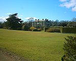
on the high ground of Beauchief. The house was built in 1671 by Edward Pegge of the Ashbourne family who had acquired the estate by marriage to Gertrude Strelley in 1648. Pegge served as Sheriff of Derbyshire in 1667 whilst resident in Pegge's cottage the house adjacent to the current hall. A fireplace in the hall shows a bust of Edward Pegge with the arms of the Pegge and Strelley families, the fire place is said to have been a gift from the Mundy family.
The hall and grounds passed from the family with the sale of the property by Edward Strelley Pegge Burnell in 1923. Ending Joseph Hunters statement in Hallamshire 1819 that "We have in this family an instance, which by some has been supposed rare, of the direct descendants of the original grantee possessing and residing upon the abbey-lands granted to their ancestor"
Since 1923 the house has served as a school (De la Salle College), a hotel and currently as headquarters of a software company . On 3 August 2010 it was announced to the stock exchange that the hall would be sold by the PLC software company in a multi million pound deal. The new owners are believed to be Blenheim ltd
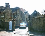
Beauchief also had a railway station situated on Abbey Lane. See Beauchief railway station for full article.
of Sheffield, England. Nearby settlements include Bradway, Meadow Head, Abbeydale and Woodseats
.
Greenhill, generally pronounced "grennell" or "green hill" if you lived there or in Bradway, has a library
, primary
school, church and shops. There are also several bus
routes which service the area including the 76, 25, 25A, M17 and 293; the last service of which even goes into Derbyshire.
. Lowedges is formed of council and private houses and flats as well as a good selection of shops and one public house, The Grennel Mower. It is home to the Transport Recreation Ground, Lowedges Fire Station, Greenhill Park, Greenhill and Bradway Youth Club, a Tenants Meeting Hall and three churches. Lowedges is a very vibrant community with over fifty activities for residents to engage in.
It is also home to The Terminus Initiative formed by the co-operation of four local churches to build an organisation capable of helping residents engage in projects and activities and provide help where needed. The Terminus Initiative runs The Terminus Cafe which is a regular meeting place for residents run by volunteers. It is a world renown venture and has been visited by delegations from both UK based and overseas organisations.
The original name "Lowedges" was given to a farm located on the east side of the Sheffield to Derby Turnpike, now called Chesterfield Road
. The farm itself was made up of several strips, located on both sides of the Turnpike which had in their names the word Lowedge. "Lowedge" in this context, is a description rather than a name, "low" being the Derbyshire name for a hill and "edge", meaning just that, a strip on the edge of a hill or low. Renting some of these strips and bring them together into a single farming unit would have prompted the tenant, one William Webster, to call this new farm "Lowedges".
A map of Greenhill derived from a survey made by W & J Fairbank in 1804 and 1805 shows and names the strips. Five of the seven strips rented by William Webster include the word Lowedge. In addition the map depicts a "Lowedge Lane" running adjacent to the east of those strips. In total there are nine fields shown with Lowedge in their name. The strip names were made up of an additional descriptor, such as "Long", "Top", "Nether", "Upper", "Five Acre" and "Four Acre". It is possible that more strips existed to the east of Lowedge Lane, that being the eastern extent of the map. The map is available from Sheffield City Libraries.
A single row of terrace houses along the west side of the southern part of Chesterfield Road
forms one of the most southerly groups of buildings in Sheffield, and is the second place to carry the name Lowedges. This terrace of houses was built between 1905 and 1910 when Lowedges Farm still existed. When the terrace was built the name Lowedges became the name of this hamlet, including both the farm and the houses.
Local Transport - First South Yorkshire
76 (High Green - Lowedges via. City Centre) (Blue Line) and 53 (Ecclesfield - Lowedges via. City Centre) terminate at Lowedges Terminus. These are high frequency buses during day time.
The estate was built circa 1964, and consists largely of prefabricated flat-roofed housing, along with blocks of maisonettes/flats.
It borders on the Derbyshire countryside and farming country, being only a couple of miles from the villages of Coal Aston and Holmesfield and on the edge of the town of Dronfield.
The estate is served by a main bus route, a public house called (appropriately) The Batemoor, and a newly built Infant & Junior school. It is also near the Jordanthorpe Shopping Centre.
Sheffield Artist Pete McKee
grew up on Batemoor and still lives in the area.
Main roads lead to the M1 motorway, and Dronfield railway station is nearby.
Local Transport - First South Yorkshire
75 (Sheffield Lane Top - Batemoor via. City Centre) (Blue Line) terminates at Jordanthrope. This is a high frequency bus during day time.
Districts of Sheffield
Sheffield is a city and metropolitan borough in the north of England. The neighbourhoods of Sheffield vary widely in size and history. Many of the neighbourhoods developed from villages or hamlets that have become absorbed into Sheffield as the city has grown...
of Batemoor, Beauchief, Chancet Wood, Greenhill, Jordanthorpe, and Lowedges—is one of the 28 electoral wards in City of Sheffield
Sheffield
Sheffield is a city and metropolitan borough of South Yorkshire, England. Its name derives from the River Sheaf, which runs through the city. Historically a part of the West Riding of Yorkshire, and with some of its southern suburbs annexed from Derbyshire, the city has grown from its largely...
, England
England
England is a country that is part of the United Kingdom. It shares land borders with Scotland to the north and Wales to the west; the Irish Sea is to the north west, the Celtic Sea to the south west, with the North Sea to the east and the English Channel to the south separating it from continental...
. It is located in the southern part of the city and covers an area of 2.4 square miles (6.2 km²). The population of this ward in 2001 was 18,600 people in 8,900 households.
It is one of the five wards that form the Sheffield Heeley parliamentary constituency.
The districts of this ward were in the historic county
Historic counties of England
The historic counties of England are subdivisions of England established for administration by the Normans and in most cases based on earlier Anglo-Saxon kingdoms and shires...
of Derbyshire
Derbyshire
Derbyshire is a county in the East Midlands of England. A substantial portion of the Peak District National Park lies within Derbyshire. The northern part of Derbyshire overlaps with the Pennines, a famous chain of hills and mountains. The county contains within its boundary of approx...
, but they were annexed into the county borough
County borough
County borough is a term introduced in 1889 in the United Kingdom of Great Britain and Ireland , to refer to a borough or a city independent of county council control. They were abolished by the Local Government Act 1972 in England and Wales, but continue in use for lieutenancy and shrievalty in...
of Sheffield in 1934 associated with the West Riding of Yorkshire
West Riding of Yorkshire
The West Riding of Yorkshire is one of the three historic subdivisions of Yorkshire, England. From 1889 to 1974 the administrative county, County of York, West Riding , was based closely on the historic boundaries...
, and were thus included in the metropolitan county
Metropolitan county
The metropolitan counties are a type of county-level administrative division of England. There are six metropolitan counties, which each cover large urban areas, typically with populations of 1.2 to 2.8 million...
of South Yorkshire
South Yorkshire
South Yorkshire is a metropolitan county in the Yorkshire and the Humber region of England. It has a population of 1.29 million. It consists of four metropolitan boroughs: Barnsley, Doncaster, Rotherham, and City of Sheffield...
in 1974.
Parks and recreation
About a third of the area of the ward is taken up by the grounds of Beauchief AbbeyBeauchief Abbey
Beauchief Abbey is a former abbey in Sheffield, England. Beauchief is prounounced bee-chiff.-History:The abbey was founded by Robert FitzRanulf de Alfreton. Thomas Tanner, writing in 1695, stated that it was founded in 1183...
and Beauchief Hall. These include Ladies' Spring Wood, Parkbank Wood, Beauchief Park, and two golf courses. Also within the ward are Hutcliff Wood
Hutcliff Wood
Hutcliff Wood and Marriott Wood are two areas of ancient woodland in Sheffield, South Yorkshire, England. They occupy the steep southeastern side of the Abbeydale valley between Archer Road and Abbey Lane, separated by the River Sheaf and the railway line from Millhouses Park...
and Chancet Wood.
Schools
Schools in this ward include Meadowhead Secondary School, Abbey Lane Primary School, Greenhill Primary School Greenhill Primary School.Beauchief
Beauchief is a former village that has become a suburbSuburb
The word suburb mostly refers to a residential area, either existing as part of a city or as a separate residential community within commuting distance of a city . Some suburbs have a degree of administrative autonomy, and most have lower population density than inner city neighborhoods...
of Sheffield. It lies on a hill above the River Sheaf
River Sheaf
The River Sheaf is a river in Sheffield, South Yorkshire, England. Its source is the union of the Totley Brook and the Old Hay Brook in Totley, now a suburb of Sheffield. It flows northwards, past Dore, through the valley called Abbeydale and north of Heeley...
and the Abbeydale Industrial Hamlet
Abbeydale Industrial Hamlet
Abbeydale Industrial Hamlet is an industrial museum in the south of the City of Sheffield, England. The museum forms part of a former steel-working site on the River Sheaf, with a history going back to at least the 13th century...
.
Beauchief, generally pronounced "bee-chiff", is notable for two buildings, still surrounded by park
Park
A park is a protected area, in its natural or semi-natural state, or planted, and set aside for human recreation and enjoyment, or for the protection of wildlife or natural habitats. It may consist of rocks, soil, water, flora and fauna and grass areas. Many parks are legally protected by...
land: Beauchief Abbey and Beauchief Hall.
Beauchief Abbey
Beauchief AbbeyBeauchief Abbey
Beauchief Abbey is a former abbey in Sheffield, England. Beauchief is prounounced bee-chiff.-History:The abbey was founded by Robert FitzRanulf de Alfreton. Thomas Tanner, writing in 1695, stated that it was founded in 1183...
was built in 1183 by the canons who had mills on the River Sheaf
River Sheaf
The River Sheaf is a river in Sheffield, South Yorkshire, England. Its source is the union of the Totley Brook and the Old Hay Brook in Totley, now a suburb of Sheffield. It flows northwards, past Dore, through the valley called Abbeydale and north of Heeley...
and a sheep grange on Strawberry Lee. It was named Beau meaning beautiful and chief meaning headland.
The abbey was founded in 1175, Beauchief Abbey was the only Premonstratensian abbey in the West Riding of Yorkshire.
The ruined abbey buildings were dismantled to provide stone for the construction of Beauchief Hall in 1671 with the exception of the bell tower. The tower area was converted into the Pegge family chapel, the interior displays several armorial plaques of Pegge family members.
The carp pond is well known spot for local anglers. The ponds are also frequented by heron and other waterfowl.
Beauchief abbey farm was built around 1700. The farm, as well as its pond, fed the monks.
The path up to Bradway passes near Beauchief Hall.
Beauchief Abbey House
Beauchief Abbey House is a group of houses on Beauchief Abbey Lane. It is situated at the bottom of the lane in view of the abbey. The barn adjacent to Beauchief Abbey House has been identified as dating from the early 16th century and a modern house in limestoneLimestone
Limestone is a sedimentary rock composed largely of the minerals calcite and aragonite, which are different crystal forms of calcium carbonate . Many limestones are composed from skeletal fragments of marine organisms such as coral or foraminifera....
and steel
Steel
Steel is an alloy that consists mostly of iron and has a carbon content between 0.2% and 2.1% by weight, depending on the grade. Carbon is the most common alloying material for iron, but various other alloying elements are used, such as manganese, chromium, vanadium, and tungsten...
has been built next to the main house. Archaeological work has been made in the grounds of house but not yet been published .
Beauchief Hall
Beauchief Hall is a large manor houseManor house
A manor house is a country house that historically formed the administrative centre of a manor, the lowest unit of territorial organisation in the feudal system in Europe. The term is applied to country houses that belonged to the gentry and other grand stately homes...
on the high ground of Beauchief. The house was built in 1671 by Edward Pegge of the Ashbourne family who had acquired the estate by marriage to Gertrude Strelley in 1648. Pegge served as Sheriff of Derbyshire in 1667 whilst resident in Pegge's cottage the house adjacent to the current hall. A fireplace in the hall shows a bust of Edward Pegge with the arms of the Pegge and Strelley families, the fire place is said to have been a gift from the Mundy family.
The hall and grounds passed from the family with the sale of the property by Edward Strelley Pegge Burnell in 1923. Ending Joseph Hunters statement in Hallamshire 1819 that "We have in this family an instance, which by some has been supposed rare, of the direct descendants of the original grantee possessing and residing upon the abbey-lands granted to their ancestor"
Since 1923 the house has served as a school (De la Salle College), a hotel and currently as headquarters of a software company . On 3 August 2010 it was announced to the stock exchange that the hall would be sold by the PLC software company in a multi million pound deal. The new owners are believed to be Blenheim ltd
Beauchief also had a railway station situated on Abbey Lane. See Beauchief railway station for full article.
Greenhill
Greenhill is a suburbSuburb
The word suburb mostly refers to a residential area, either existing as part of a city or as a separate residential community within commuting distance of a city . Some suburbs have a degree of administrative autonomy, and most have lower population density than inner city neighborhoods...
of Sheffield, England. Nearby settlements include Bradway, Meadow Head, Abbeydale and Woodseats
Woodseats
Woodseats is a district of Sheffield, South Yorkshire in the Graves Park ward. Historically, Norton Woodseats was a village that straddled Derbyshire Lane running from Four Lane Ends to Bolehill , originally in Derbyshire but since 1934, part of the City of Sheffield.The name Woodseats comes from...
.
Greenhill, generally pronounced "grennell" or "green hill" if you lived there or in Bradway, has a library
Library
In a traditional sense, a library is a large collection of books, and can refer to the place in which the collection is housed. Today, the term can refer to any collection, including digital sources, resources, and services...
, primary
Primary education
A primary school is an institution in which children receive the first stage of compulsory education known as primary or elementary education. Primary school is the preferred term in the United Kingdom and many Commonwealth Nations, and in most publications of the United Nations Educational,...
school, church and shops. There are also several bus
Bus
A bus is a road vehicle designed to carry passengers. Buses can have a capacity as high as 300 passengers. The most common type of bus is the single-decker bus, with larger loads carried by double-decker buses and articulated buses, and smaller loads carried by midibuses and minibuses; coaches are...
routes which service the area including the 76, 25, 25A, M17 and 293; the last service of which even goes into Derbyshire.
Lowedges
Lowedges has some 3,000 homes and is located at the southern edge of the city on the boundary with DerbyshireDerbyshire
Derbyshire is a county in the East Midlands of England. A substantial portion of the Peak District National Park lies within Derbyshire. The northern part of Derbyshire overlaps with the Pennines, a famous chain of hills and mountains. The county contains within its boundary of approx...
. Lowedges is formed of council and private houses and flats as well as a good selection of shops and one public house, The Grennel Mower. It is home to the Transport Recreation Ground, Lowedges Fire Station, Greenhill Park, Greenhill and Bradway Youth Club, a Tenants Meeting Hall and three churches. Lowedges is a very vibrant community with over fifty activities for residents to engage in.
It is also home to The Terminus Initiative formed by the co-operation of four local churches to build an organisation capable of helping residents engage in projects and activities and provide help where needed. The Terminus Initiative runs The Terminus Cafe which is a regular meeting place for residents run by volunteers. It is a world renown venture and has been visited by delegations from both UK based and overseas organisations.
The original name "Lowedges" was given to a farm located on the east side of the Sheffield to Derby Turnpike, now called Chesterfield Road
Chesterfield Road (Sheffield)
Chesterfield Road is a shopping street in Sheffield, England. It leads south from the suburb of Meersbrook to Woodseats, before becoming Meadowhead at the Abbey Lane junction, next to the Abbey pub. The road starts at Toll Bar bridge on the Meers Brook, the former boundary between Yorkshire and...
. The farm itself was made up of several strips, located on both sides of the Turnpike which had in their names the word Lowedge. "Lowedge" in this context, is a description rather than a name, "low" being the Derbyshire name for a hill and "edge", meaning just that, a strip on the edge of a hill or low. Renting some of these strips and bring them together into a single farming unit would have prompted the tenant, one William Webster, to call this new farm "Lowedges".
A map of Greenhill derived from a survey made by W & J Fairbank in 1804 and 1805 shows and names the strips. Five of the seven strips rented by William Webster include the word Lowedge. In addition the map depicts a "Lowedge Lane" running adjacent to the east of those strips. In total there are nine fields shown with Lowedge in their name. The strip names were made up of an additional descriptor, such as "Long", "Top", "Nether", "Upper", "Five Acre" and "Four Acre". It is possible that more strips existed to the east of Lowedge Lane, that being the eastern extent of the map. The map is available from Sheffield City Libraries.
A single row of terrace houses along the west side of the southern part of Chesterfield Road
Chesterfield Road (Sheffield)
Chesterfield Road is a shopping street in Sheffield, England. It leads south from the suburb of Meersbrook to Woodseats, before becoming Meadowhead at the Abbey Lane junction, next to the Abbey pub. The road starts at Toll Bar bridge on the Meers Brook, the former boundary between Yorkshire and...
forms one of the most southerly groups of buildings in Sheffield, and is the second place to carry the name Lowedges. This terrace of houses was built between 1905 and 1910 when Lowedges Farm still existed. When the terrace was built the name Lowedges became the name of this hamlet, including both the farm and the houses.
Local Transport - First South Yorkshire
First South Yorkshire
First South Yorkshire is the largest bus operator in South Yorkshire, England. As a division of FirstGroup the company's legal name was, for a time, Mainline which operated it between 1993 and 1998, following the sale South Yorkshire Transport to its employees.-History:SYT was eventually sold to...
76 (High Green - Lowedges via. City Centre) (Blue Line) and 53 (Ecclesfield - Lowedges via. City Centre) terminate at Lowedges Terminus. These are high frequency buses during day time.
Batemoor
Batemoor is a housing estate in the south of Sheffield. It is located to the southeast of Greenhill and borders Lowedges, Norton, Jordanthorpe and Dronfield.The estate was built circa 1964, and consists largely of prefabricated flat-roofed housing, along with blocks of maisonettes/flats.
It borders on the Derbyshire countryside and farming country, being only a couple of miles from the villages of Coal Aston and Holmesfield and on the edge of the town of Dronfield.
The estate is served by a main bus route, a public house called (appropriately) The Batemoor, and a newly built Infant & Junior school. It is also near the Jordanthorpe Shopping Centre.
Sheffield Artist Pete McKee
Pete McKee
Pete McKee is a painter and commercial artist from Sheffield, England. He is a cartoonist for the Sheffield Telegraph’s sports section. He has exhibited regularly around the north of England. Using bright colours his larger than life, often humorous characters inhabit a world of working men's...
grew up on Batemoor and still lives in the area.
Main roads lead to the M1 motorway, and Dronfield railway station is nearby.
Jordanthorpe
Jordanthorpe is located to the east of Greenhill and south of Norton.Local Transport - First South Yorkshire
First South Yorkshire
First South Yorkshire is the largest bus operator in South Yorkshire, England. As a division of FirstGroup the company's legal name was, for a time, Mainline which operated it between 1993 and 1998, following the sale South Yorkshire Transport to its employees.-History:SYT was eventually sold to...
75 (Sheffield Lane Top - Batemoor via. City Centre) (Blue Line) terminates at Jordanthrope. This is a high frequency bus during day time.