
River Sheaf
Encyclopedia
The River Sheaf is a river in Sheffield
, South Yorkshire
, England
. Its source is the union of the Totley Brook
and the Old Hay Brook
in Totley
, now a suburb of Sheffield. It flows northwards, past Dore
, through the valley called Abbeydale (so named because of Beauchief Abbey
, which overlooks it) and north of Heeley
. It then passes into a culvert
, through which it flows under the centre of Sheffield emerging from time to time until joining the River Don near Blonk Street Bridge. This lower section of the River Sheaf together with the River Don, between the present Blonk Street and Lady's Bridge
s, formed two sides of the boundary of Sheffield Castle
.
The main tributaries of the Sheaf are the Porter Brook
, which joins it beneath Sheffield Midland station
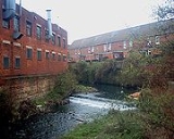
, and the Meers Brook. The river has been polluted upstream through centuries of industrial activity, including iron
and steel
working, and is only slowly recovering. The river used to provide the power for a number of metal works, an important surviving example of which is the Grade 1-listed Abbeydale Industrial Hamlet
.
A Sheaf Valley Walk is being developed that will follow the river from Granville Square out to Millhouses Park
and beyond to the Peak District
.
shed (as in water-shed) or sheth, which mean to divide, or separate. Historically, the Sheaf—along with its tributaries the Meers Brook
and the Limb Brook
—formed part of the border separating the Anglo-Saxon
kingdoms of Mercia
and Northumbria
; it remained on the border between Yorkshire
and Derbyshire
into the 20th century. The city of Sheffield derives its name from the Sheaf.
, which then joins the Midland Main Line
, and both cross back over to reach Dore and Totley railway station, which was built on the site of Walk Mill in 1872. The river shares its valley with the railway, and there are a further five crossings before both reach Sheffield Station.
From the junction of the Redcar Brook and the Old Hay Brook to the city centre, the river descends by around 400 feet (121.9 m), and this fall has resulted in it being harnessed to provide water power for a number of industries from at least the 16th century.
The river valley is broad, cutting through the underlying coal measures
with its sandstones
and clays
, and the location of harder rock has been a major factor in where weirs
and dams (a local word for the ponds used to hold water rather than the structure that creates the pond) have been located. There are some 28 sites which have well-documented and long standing mills associated with them, and a further seven were located on some of the smaller tributaries, or were more transitory in nature. The Sheaf supplied a greater variety of industry than the other Sheffield rivers, partly because of its close proximity to Derbyshire
, with its mineral reserves of lead
. The lead ore was brought to the area around Dore, Totley and Norton, which was then in Derbyshire. There were at least ten mills where the ore was smelted in ore hearths, which used kiln-dried wood as the heat producing agent, and water-powered bellows to produce the temperatures required. As well as the lead smelting mills, there were a variety of corn and paper mills along the river, some of which were adapted in the 18th century to service the metal trades as they grew and expanded.
Walk mill was one of the earliest known mills on the Sheaf, having been built around 1280 by the Canons of Beauchief Abbey as a fulling mill. After the abbey was dissolved in the reign of Henry VIII, it was used as a cutlers wheel. By 1746 John Tyzack was using it for grinding scythes, in 1797 Thomas Biggin was making knives for cutting hay and straw, and it was being used as a sickle mill in 1805. After a brief spell as a paper mill around 1826, it was occupied by Thomas Tyzack and Sons, who made saws. The site was sold to the Midland Railway by the Duke of Devonshire in 1871 for the construction of Dore and Totley station, and the last mill buildings were taken down in 1890.
Below Walk Mill, the Limb Brook flows in from the west. Whirlow Wheel was situated on the brook, and was used for milling corn between about 1586 until 1803, when a grinding wheel was added. With the building decaying, the site was sold to Sheffield Corporation in 1935. The roof of the building collapsed in 2006, but although there were calls to demolish it, the Friends of Whirlow Wheel campaigned for it to be retained until a use could be found for the site.
Abbeydale works is located just below the Limb Brook and was powered by two water wheels. In 1855, these were supplemented by a steam engine, but the site declined after 1900. It was given to Sheffield Corporation in 1935 as an industrial museum, and only an active campaign by members of a local history group prevented its demolition. Restoration eventually began in 1964, and it was opened as a museum in 1970. The Abbey Brook then joins the river from the east, below which the river is bordered by Millhouses Park
. In order to reduce flooding and pollution of the river when the sewerage system is overloaded by heavy rainfall, Yorkshire Water excavated the park in 2004/5 to construct a tank capable of holding 10000 cubic metres (353,146.7 cu ft) of storm water. The decision to build a tank rather than a vertical shaft was made after test boreholes found hard rock and high groundwater pressure in the area. The project cost £7.5 million, and included three more conventional shafts further down the river, which provide an additional 3175 cubic metres (112,124.1 cu ft) of storage.
Little London wheel was used for the cutlery trade from the earliest known records in 1720. By 1814 it was described as a grinding and plating forge, and later was used for the production of scythes. When the railway was constructed, it crossed part of the dam, which was reduced in size by one eighth. By 1912 the water wheels had been modernised and there were two tilt hammers in operation. The owners moved their scythe production from Abbeydale Works to Little London on 1935, and the tilt hammers continued to be water-powered until the mid 1950s. Some of the equipment was dismantled in the 1970s and taken to Beamish Museum
to be restored.
The next tributary is the Meers Brook
, culverted for its last section under the suburban district of Meersbrook
. Just below the junction is Heeley Station, built on the site of Heeley Wheel. The mill was demolished and the river was diverted by the railway company. Other sections of the river were also re-aligned in the 1860s to make way for the railway, and the weir at the site of Cooper Wheel, which can be seen from Havelock bridge, was probably built by the Midland Railway, as its orientation changed around that time.
From Granville Square to the Don, the river is almost entirely in culverts. The Midland Railway bought the water rights to allow them to build their station over the river. The site of Pond Tilt is now occupied by the station forecourt, and the goods yard covered its dam. The owners of Pond Forge vacated their site soon after the station was built, but attempted to get compensation for loss of water power as a result of the work.
At Granville Square, a large screen prevents debris from entering the culverts. Serious flooding in 1990 led to the construction of the first screen, and it was refurbished in 2010, so that it could be continuously monitored by the Environment Agency
. The river continues below ground to the edge of the station, where it is joined underground by the Porter Brook
, which emerges from its own culvert to flow beside the station car park before passing under the station from the west. The river surfaces briefly by Pond Hill, before passing under the Ponds Forge district. It flows through a huge cavern before joining the Don beside Blonk Street bridge, named after Benjamin Blonk, who was the tenant of Castle Orchards Wheel from the 1750s to the 1770s.
Sheffield
Sheffield is a city and metropolitan borough of South Yorkshire, England. Its name derives from the River Sheaf, which runs through the city. Historically a part of the West Riding of Yorkshire, and with some of its southern suburbs annexed from Derbyshire, the city has grown from its largely...
, South Yorkshire
South Yorkshire
South Yorkshire is a metropolitan county in the Yorkshire and the Humber region of England. It has a population of 1.29 million. It consists of four metropolitan boroughs: Barnsley, Doncaster, Rotherham, and City of Sheffield...
, England
England
England is a country that is part of the United Kingdom. It shares land borders with Scotland to the north and Wales to the west; the Irish Sea is to the north west, the Celtic Sea to the south west, with the North Sea to the east and the English Channel to the south separating it from continental...
. Its source is the union of the Totley Brook
Totley Brook
The Totley Brook is a stream in Sheffield, South Yorkshire, England. It rises on a millstone grit ridge some to the south-west of the centre of Sheffield. Over its course it drops from to near its junction with the Old Hay Brook close to Baslow Road...
and the Old Hay Brook
Old Hay Brook
The Old Hay Brook is a stream in Sheffield, South Yorkshire. Near Totley Grange the streams joins Needham's Dyke, which flowed from within the Grange estate, joins the Brook under one of the many footpaths in the neighbouring woods....
in Totley
Totley
Totley is a suburb on the extreme southwest of the City of Sheffield, in South Yorkshire, England. Lying in the historic county boundaries of Derbyshire, Totley was amalgamated into the city of Sheffield in 1935, and is today part of the Dore and Totley electoral ward in the city, though it remains...
, now a suburb of Sheffield. It flows northwards, past Dore
Dore
Dore is a village in South Yorkshire, England. The village lies on a hill above the River Sheaf, and until 1934 was part of Derbyshire, but it is now a suburb of Sheffield. It is served by Dore and Totley railway station on the Hope Valley Line...
, through the valley called Abbeydale (so named because of Beauchief Abbey
Beauchief Abbey
Beauchief Abbey is a former abbey in Sheffield, England. Beauchief is prounounced bee-chiff.-History:The abbey was founded by Robert FitzRanulf de Alfreton. Thomas Tanner, writing in 1695, stated that it was founded in 1183...
, which overlooks it) and north of Heeley
Heeley
Heeley is a former cluster of villages now a suburb in the south of the City of Sheffield, England. The village has existed at least since 1343, its name deriving from Heah Leah, High Lea then Hely, meaning a high, woodland clearing...
. It then passes into a culvert
Culvert
A culvert is a device used to channel water. It may be used to allow water to pass underneath a road, railway, or embankment. Culverts can be made of many different materials; steel, polyvinyl chloride and concrete are the most common...
, through which it flows under the centre of Sheffield emerging from time to time until joining the River Don near Blonk Street Bridge. This lower section of the River Sheaf together with the River Don, between the present Blonk Street and Lady's Bridge
Lady's Bridge
Lady's Bridge is the oldest bridge across the River Don in the City of Sheffield, England. It is located in the central section of the city, linking the Wicker to the north with Waingate to the south.-The first bridge:...
s, formed two sides of the boundary of Sheffield Castle
Sheffield Castle
Sheffield Castle was a castle in Sheffield, England, constructed at the confluence of the River Sheaf and the River Don, possibly on the site of a former Anglo-Saxon long house, and dominating the early town. A motte and bailey castle had been constructed on the site at some time in the century...
.
The main tributaries of the Sheaf are the Porter Brook
Porter Brook
The Porter Brook is a river in the City of Sheffield, Englanddescending over 300 metres from its source among the sedge grass on Burbage moor behind a small farm on Hangram just inside the Peak District National Park in the west of the city at Clough Hollow, near the village of Ringinglow...
, which joins it beneath Sheffield Midland station
Sheffield Midland station
Sheffield station, formerly Pond Street and later Sheffield Midland, is a railway station in Sheffield, England and is the busiest station in South Yorkshire...
, and the Meers Brook. The river has been polluted upstream through centuries of industrial activity, including iron
Iron
Iron is a chemical element with the symbol Fe and atomic number 26. It is a metal in the first transition series. It is the most common element forming the planet Earth as a whole, forming much of Earth's outer and inner core. It is the fourth most common element in the Earth's crust...
and steel
Steel
Steel is an alloy that consists mostly of iron and has a carbon content between 0.2% and 2.1% by weight, depending on the grade. Carbon is the most common alloying material for iron, but various other alloying elements are used, such as manganese, chromium, vanadium, and tungsten...
working, and is only slowly recovering. The river used to provide the power for a number of metal works, an important surviving example of which is the Grade 1-listed Abbeydale Industrial Hamlet
Abbeydale Industrial Hamlet
Abbeydale Industrial Hamlet is an industrial museum in the south of the City of Sheffield, England. The museum forms part of a former steel-working site on the River Sheaf, with a history going back to at least the 13th century...
.
A Sheaf Valley Walk is being developed that will follow the river from Granville Square out to Millhouses Park
Millhouses Park
Millhouses Park is a public urban park located in the Millhouses neighbourhood in south of Sheffield, England. It is a park stretching approximately along the floor of the valley of the River Sheaf, sandwiched between Abbeydale Road South and the railway tracks of the Midland Main Line.-Early...
and beyond to the Peak District
Peak District
The Peak District is an upland area in central and northern England, lying mainly in northern Derbyshire, but also covering parts of Cheshire, Greater Manchester, Staffordshire, and South and West Yorkshire....
.
Name
Until the 17th century the name Sheaf was written as Scheth or Sheath. Sidney Oldall Addy equates the origins of this word with the Old EnglishOld English language
Old English or Anglo-Saxon is an early form of the English language that was spoken and written by the Anglo-Saxons and their descendants in parts of what are now England and southeastern Scotland between at least the mid-5th century and the mid-12th century...
shed (as in water-shed) or sheth, which mean to divide, or separate. Historically, the Sheaf—along with its tributaries the Meers Brook
Meers Brook
The Meers Brook is a stream in Sheffield, England and one of the main tributaries of the River Sheaf.The Meers Brook originates in Gleadless and flows downhill through Gleadless Valley and Meersbrook then, tunnelled, continues underneath Meersbrook to pour into the River Sheaf near Saxon Road and...
and the Limb Brook
Limb Brook
The Limb Brook is a stream in Sheffield, South Yorkshire, England. It rises at the village of Ringinglow, flowing east through Whirlow and Ecclesall Woods into Abbeydale in the Beauchief area, where it merges with the River Sheaf...
—formed part of the border separating the Anglo-Saxon
Anglo-Saxons
Anglo-Saxon is a term used by historians to designate the Germanic tribes who invaded and settled the south and east of Great Britain beginning in the early 5th century AD, and the period from their creation of the English nation to the Norman conquest. The Anglo-Saxon Era denotes the period of...
kingdoms of Mercia
Mercia
Mercia was one of the kingdoms of the Anglo-Saxon Heptarchy. It was centred on the valley of the River Trent and its tributaries in the region now known as the English Midlands...
and Northumbria
Northumbria
Northumbria was a medieval kingdom of the Angles, in what is now Northern England and South-East Scotland, becoming subsequently an earldom in a united Anglo-Saxon kingdom of England. The name reflects the approximate southern limit to the kingdom's territory, the Humber Estuary.Northumbria was...
; it remained on the border between Yorkshire
Yorkshire
Yorkshire is a historic county of northern England and the largest in the United Kingdom. Because of its great size in comparison to other English counties, functions have been increasingly undertaken over time by its subdivisions, which have also been subject to periodic reform...
and Derbyshire
Derbyshire
Derbyshire is a county in the East Midlands of England. A substantial portion of the Peak District National Park lies within Derbyshire. The northern part of Derbyshire overlaps with the Pennines, a famous chain of hills and mountains. The county contains within its boundary of approx...
into the 20th century. The city of Sheffield derives its name from the Sheaf.
Course
The waters which form the River Sheaf rise as a series of streams on a ridge of gritstone between 6 and 7 mi (9.7 and 11.3 km) to the south west of the main city centre. The Blacka Dike, Needhams Dike and Redcar Brook combine to form Old Hay Brook, while Totley Brook is joined by Rodmoor Brook, and itself joins Old Hay Brook, after which the combined flow forms the Sheaf. Immediately below the junction, the river is crossed by the Hope Valley railway lineHope Valley Line
The Hope Valley Line is a railway line in England linking Sheffield with Manchester. It was completed in 1894.From Sheffield, trains head down the Midland Main Line to Dore, where the Hope Valley Line branches off to run through the Totley Tunnel .It emerges in the stunning scenery of the Hope...
, which then joins the Midland Main Line
Midland Main Line
The Midland Main Line is a major railway route in the United Kingdom, part of the British railway system.The present-day line links London St...
, and both cross back over to reach Dore and Totley railway station, which was built on the site of Walk Mill in 1872. The river shares its valley with the railway, and there are a further five crossings before both reach Sheffield Station.
From the junction of the Redcar Brook and the Old Hay Brook to the city centre, the river descends by around 400 feet (121.9 m), and this fall has resulted in it being harnessed to provide water power for a number of industries from at least the 16th century.
The river valley is broad, cutting through the underlying coal measures
Coal Measures
The Coal Measures is a lithostratigraphical term for the coal-bearing part of the Upper Carboniferous System. It represents the remains of fluvio-deltaic sediment, and consists mainly of clastic rocks interstratified with the beds of coal...
with its sandstones
Sandstone
Sandstone is a sedimentary rock composed mainly of sand-sized minerals or rock grains.Most sandstone is composed of quartz and/or feldspar because these are the most common minerals in the Earth's crust. Like sand, sandstone may be any colour, but the most common colours are tan, brown, yellow,...
and clays
Clay
Clay is a general term including many combinations of one or more clay minerals with traces of metal oxides and organic matter. Geologic clay deposits are mostly composed of phyllosilicate minerals containing variable amounts of water trapped in the mineral structure.- Formation :Clay minerals...
, and the location of harder rock has been a major factor in where weirs
Weir
A weir is a small overflow dam used to alter the flow characteristics of a river or stream. In most cases weirs take the form of a barrier across the river that causes water to pool behind the structure , but allows water to flow over the top...
and dams (a local word for the ponds used to hold water rather than the structure that creates the pond) have been located. There are some 28 sites which have well-documented and long standing mills associated with them, and a further seven were located on some of the smaller tributaries, or were more transitory in nature. The Sheaf supplied a greater variety of industry than the other Sheffield rivers, partly because of its close proximity to Derbyshire
Derbyshire
Derbyshire is a county in the East Midlands of England. A substantial portion of the Peak District National Park lies within Derbyshire. The northern part of Derbyshire overlaps with the Pennines, a famous chain of hills and mountains. The county contains within its boundary of approx...
, with its mineral reserves of lead
Lead
Lead is a main-group element in the carbon group with the symbol Pb and atomic number 82. Lead is a soft, malleable poor metal. It is also counted as one of the heavy metals. Metallic lead has a bluish-white color after being freshly cut, but it soon tarnishes to a dull grayish color when exposed...
. The lead ore was brought to the area around Dore, Totley and Norton, which was then in Derbyshire. There were at least ten mills where the ore was smelted in ore hearths, which used kiln-dried wood as the heat producing agent, and water-powered bellows to produce the temperatures required. As well as the lead smelting mills, there were a variety of corn and paper mills along the river, some of which were adapted in the 18th century to service the metal trades as they grew and expanded.
Walk mill was one of the earliest known mills on the Sheaf, having been built around 1280 by the Canons of Beauchief Abbey as a fulling mill. After the abbey was dissolved in the reign of Henry VIII, it was used as a cutlers wheel. By 1746 John Tyzack was using it for grinding scythes, in 1797 Thomas Biggin was making knives for cutting hay and straw, and it was being used as a sickle mill in 1805. After a brief spell as a paper mill around 1826, it was occupied by Thomas Tyzack and Sons, who made saws. The site was sold to the Midland Railway by the Duke of Devonshire in 1871 for the construction of Dore and Totley station, and the last mill buildings were taken down in 1890.
Below Walk Mill, the Limb Brook flows in from the west. Whirlow Wheel was situated on the brook, and was used for milling corn between about 1586 until 1803, when a grinding wheel was added. With the building decaying, the site was sold to Sheffield Corporation in 1935. The roof of the building collapsed in 2006, but although there were calls to demolish it, the Friends of Whirlow Wheel campaigned for it to be retained until a use could be found for the site.
Abbeydale works is located just below the Limb Brook and was powered by two water wheels. In 1855, these were supplemented by a steam engine, but the site declined after 1900. It was given to Sheffield Corporation in 1935 as an industrial museum, and only an active campaign by members of a local history group prevented its demolition. Restoration eventually began in 1964, and it was opened as a museum in 1970. The Abbey Brook then joins the river from the east, below which the river is bordered by Millhouses Park
Millhouses Park
Millhouses Park is a public urban park located in the Millhouses neighbourhood in south of Sheffield, England. It is a park stretching approximately along the floor of the valley of the River Sheaf, sandwiched between Abbeydale Road South and the railway tracks of the Midland Main Line.-Early...
. In order to reduce flooding and pollution of the river when the sewerage system is overloaded by heavy rainfall, Yorkshire Water excavated the park in 2004/5 to construct a tank capable of holding 10000 cubic metres (353,146.7 cu ft) of storm water. The decision to build a tank rather than a vertical shaft was made after test boreholes found hard rock and high groundwater pressure in the area. The project cost £7.5 million, and included three more conventional shafts further down the river, which provide an additional 3175 cubic metres (112,124.1 cu ft) of storage.
Little London wheel was used for the cutlery trade from the earliest known records in 1720. By 1814 it was described as a grinding and plating forge, and later was used for the production of scythes. When the railway was constructed, it crossed part of the dam, which was reduced in size by one eighth. By 1912 the water wheels had been modernised and there were two tilt hammers in operation. The owners moved their scythe production from Abbeydale Works to Little London on 1935, and the tilt hammers continued to be water-powered until the mid 1950s. Some of the equipment was dismantled in the 1970s and taken to Beamish Museum
Beamish Museum
Beamish, The North of England Open Air Museum is an open-air museum located at Beamish, near the town of Stanley, County Durham, England. The museum's guiding principle is to preserve an example of everyday life in urban and rural North East England at the climax of industrialisation in the early...
to be restored.
The next tributary is the Meers Brook
Meers Brook
The Meers Brook is a stream in Sheffield, England and one of the main tributaries of the River Sheaf.The Meers Brook originates in Gleadless and flows downhill through Gleadless Valley and Meersbrook then, tunnelled, continues underneath Meersbrook to pour into the River Sheaf near Saxon Road and...
, culverted for its last section under the suburban district of Meersbrook
Meersbrook
Meersbrook is a suburban district in the Gleadless Valley ward of Sheffield, England located to the south of Heeley. The name comes from the stream, the Meers Brook, a tributary of the River Sheaf which means 'boundary brook' and in ancient times this, along with the River Sheaf formed the...
. Just below the junction is Heeley Station, built on the site of Heeley Wheel. The mill was demolished and the river was diverted by the railway company. Other sections of the river were also re-aligned in the 1860s to make way for the railway, and the weir at the site of Cooper Wheel, which can be seen from Havelock bridge, was probably built by the Midland Railway, as its orientation changed around that time.
From Granville Square to the Don, the river is almost entirely in culverts. The Midland Railway bought the water rights to allow them to build their station over the river. The site of Pond Tilt is now occupied by the station forecourt, and the goods yard covered its dam. The owners of Pond Forge vacated their site soon after the station was built, but attempted to get compensation for loss of water power as a result of the work.
At Granville Square, a large screen prevents debris from entering the culverts. Serious flooding in 1990 led to the construction of the first screen, and it was refurbished in 2010, so that it could be continuously monitored by the Environment Agency
Environment Agency
The Environment Agency is a British non-departmental public body of the Department for Environment, Food and Rural Affairs and an Assembly Government Sponsored Body of the Welsh Assembly Government that serves England and Wales.-Purpose:...
. The river continues below ground to the edge of the station, where it is joined underground by the Porter Brook
Porter Brook
The Porter Brook is a river in the City of Sheffield, Englanddescending over 300 metres from its source among the sedge grass on Burbage moor behind a small farm on Hangram just inside the Peak District National Park in the west of the city at Clough Hollow, near the village of Ringinglow...
, which emerges from its own culvert to flow beside the station car park before passing under the station from the west. The river surfaces briefly by Pond Hill, before passing under the Ponds Forge district. It flows through a huge cavern before joining the Don beside Blonk Street bridge, named after Benjamin Blonk, who was the tenant of Castle Orchards Wheel from the 1750s to the 1770s.