
Banks, Lancashire
Encyclopedia
Banks is a large coastal village in Lancashire
, England
. It lies just south of the Ribble estuary
and four miles (6 km) north-east of the town of Southport
. The village is administered by West Lancashire Borough Council
, and by North Meols
parish council for parochial matters. It falls in the South Ribble
parliamentary constituency. According to the 2001 census, the population of Banks was 3,792.
Banks is the largest of the villages of the parish of North Meols on the West Lancashire coastal plain
. Like most villages in the area, it was primarily an agricultural village thanks to the excellent soil, although there was also noticeable fishing activity for many years. Production of flowers and vegetables is still common in the farms which surround the village; however the proximity of the towns of Southport and Preston have led to Banks recent rapid expansion as a dormitory town for commuters.
that were built in the north of the village to protect the village from winter floods due to the River Ribble
's tides. The old embankments can be seen on the left side of the road when entering Banks at Marsh Road and can be seen in greater size further along at the end of George's Lane. However, these embankments became useless when the River Ribble started to retreat in the 1900s and larger ones are now in place further north creating extra farmland.
Local people often refer to the village as Bonks ; this is the retained Middle English
pronunciation of the village name.
in 1154. It relates to a Guide House for travellers who forded the River Ribble
from the Fylde
to North Meols
. At this time the area was on the most northern fringe of the ancient division of West Derby
and the local area was called meles, meaning sandunes.
The area was isolated to the north and west by the Ribble estuary, to the south by a chain of barren sand hills, to the east by a lake called Martin Mere - which at the time was the largest lake in England covering 3132 acres (12.7 km²).
The biggest ever coastal disaster in the area came in 1790 when 5,000 acres of the Riible estuary, from Crossens to Hesketh Bank and Tarleton were flooded, when the sea banks broke down. Forty seven houses were recorded to have been carried away by the tidal flood. Nine people drowned whilst cattle, sheep and crops were lost.
Historically, North Meols has been centred around St. Cuthbert's Church
in Churchtown, although there were vicarages in Crossens, Banks and Birkdale. Parts of the parish were almost completely surrounded by water until large scale drainage of Martin Mere
and other marshland . This was done by the construction of irrigation and sluice ditches that where constructed by Thomas Fleetwood of Bank Hall
in 1692 with further attempts in 1780. The drainage was completely successful in the 19th Century with the cronstruction of Crossens pumping station. This left behind a legacy of fine agricultural soil, which is still exploited to this day - the primary industry in the area is farming, especially of flowers and vegetables.
, fully opened on 19 February 1878, which ran between Southport
and Preston
, carrying both passengers and cargo
from the fields of the area to be sold at town markets. The station had a depot in its goods yard for coal merchants in Banks. Along the track it crossed Hoole Lane, Long Lane and Square House Lane. On all crossings they had a keeper who opened the gates for farmers and anyone else wanting to take vehicles or cows across the track.
Low passenger numbers later led to the railway's decline and its closure was assured by the Beeching Axe
on 7 September 1964.
The stone bridge supports can still be seen that used to carry the track across the sluice ditches in Banks and the old station platform still exists behind the houses of Schwartzman's Drive. Although the steel track has been taken away, the route is now used as a public path across the whole of the village.
and represented by the Conservative MP
Lorraine Fullbrook .
Banks is one of the two remaining villages within the historical civil parish
of North Meols
. At local government level, North Meols is administered by West Lancashire Borough Council
. North Meols is currently represented by the Conservative John Baldock, who is also the current Mayor of West Lancashire Borough Council, and the Conservative Paul Blane.
. This election was held on the 6th of May 2010.
On the 5th May 2011 there was a local election in North Meols.
. The closest cities are Preston approximately 20 kilometres (12 mi) to the north east and Liverpool
approximately 20 kilometres (12 mi) to the south west. The nearest town is Southport
at 6 kilometres (4 mi) south west of the village.
Existing on the West Lancashire Coastal Plain
, most of the village is only slightly above sea-level and parts of Banks can be susceptible to flooding. There are embankments
to the north of the village and there are drainage systems across the area, most notably the pumping station on Banks Road, Crossens
.
The drainage of Martin Mere
in the mid-19th century created a legacy of fine agricultural soil in the area, which is still exploited to this day - the primary industry in the area is farming, especially of flowers and vegetables.
The local area has a maritime climate
like most of the UK. Due to its position by the coast. The area rarely sees substantial snowfall and temperatures rarely fall below –5 °C so it does not have frequent frost
s. Banks generally has moderate precipitation, unlike the rest of western UK.
There are three other areas which are in the civil parish
of North Meols
:
. It is one of the most important sites in the United Kingdom
for wintering wildfowl.
The reserve, established in 1979, occupies over half of the total area of the Ribble Estuary, including extensive areas of mud and sand flats and almost all of the salt marsh
habitat - one of the largest single areas of salt marsh
in England
. Its 4,697 hectares (11,613 acres) contain large areas of intertidal mud and sand flats and the largest single area of salt marsh in northwest England.
In light of its importance the reserve has been declared a Ramsar site and a Special Protection Area
(SPA).
In the summer the salt marsh supports large numbers of breeding birds including Black-headed Gull
, European Herring Gull, Lesser Black-backed Gull
, Common Tern
and Common Redshank
. Skylark
, Meadow Pipit
and Linnet
nest in significant numbers on the grazing marsh
. Management of the site involves grazing the salt marsh with cattle
to maintain the short sward on which wintering wildfowl (especially Eurasian Wigeon and the Pink-footed Goose
) depend.
The main area of salt marsh is grazed by approximately 800 cattle
from May to October, forming one of the largest single herds of cattle in the UK. Wildfowling also takes place on much of the reserve and improved management of this activity has contributed to the increase in the number of birds visiting the site. A group of volunteers led by the local Wildfowlers Association carries out much of the valuable maintenance work on the reserve.
The Ribble Estuary is an important part of the network of wetland sites in Western Europe
. It supports over a quarter of a million waders and wildfowl each winter, and is an internationally important site for twenty species of birds. Recreation
, fishing
, wildfowling and farming all take place within the estuary
in balance with the wildlife interest.
the population of North Meols
was 3,793, and 3,730 of those people were White in skin colour. Only 60 people in the viilage were from other ethnicity in 2001. However this census was taken in 2001 and the population has said have raised significtly in the area, therefore we will have to wait until the new 2011 cenus
results come out to find the true population of the village now.
, Liverpool
and Preston. There is also notable farming activity (like most villages in the area). Farming in the village has been the core of the community for hundreds of years, however now it is less so. Most of the produce grown in the farms used to be sold to local markets, but now most of it is either sold to national companies like Marks and Spencer or even to other countries in the EU.
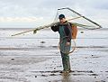 Originally Banks had a thriving shrimping industry; however, this has dwindled to almost nothing due to cheaper foreign competition.
Recently however, there has been a rapid interest on Banks Marsh as the edible seaweed Samphire
(locally known as Sampi) is being picked there. It is only found on very few coastal areas in Europe
. This is picked by local people in the Summer months and mostly sold to a supermarket called Booths
that sells local produce.
There are two business areas in Banks, which are made up of a few small businesses that provide services for the area. One is on the A565 (Southport New Road) and the other is on the former grounds of Greaves Hall. There are also other businesses across the village.
The village attracts walkers as Banks has many public footpaths, and Banks Marsh attracts bird watchers. In addition many cyclists pass though the village and in recent years The Tour of Britain has passed though Banks on the A565.
 Thomas Talbot Leyland Scarisbrick
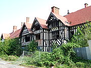
was born in 1874. He grew up in Southport and was educated in Lancashire. In 1900 he had a mansion built at Greaves Hall on a 124 acre (0.50181064 km²) site. There was also a porter's lodge by the main entrance, a gardener's lodge, engineer's workshop, laundry and general workshop, all built in close proximity to the hall, in mock Tudor style. The mansion was surrounded by sculptured lawns, with separate gardens filled with ornamental trees and flowering shrubs. The hall had approximately 55 rooms, open areas situated on the ground, first, second and attic floors and a vast basement.
The Scarisbrick family enjoyed life at Greaves Hall until after the First World War when they moved to Scarisbrick Hall
and negotiated the sale of the estate to a consortium of Banks farmers. The mansion stood empty for sometime while the land was cultivated by the consortium.
The mansion house and grounds were later occupied by Sherbrook School for Girls. The school was shut down when the Health Authority wanted to use the mansion house as a TB
hospital and, later, to bring patients with mental health and learning disabilities from Liverpool during and after the Second World War. Greaves Hall Mental Health Hospital
, included extensive developments of maintenance buildings and wards built in the former leisure grounds wirh the mansion house at the centre and used as administration offices with the addition of an X-ray installed into a north room at the front of the house. The hospital continued to grow and develop up until the early 1990s when it was moved to Southport.
Given Grade II listed status in 1997, the Greaves Hall mansion had suffered many fires and vandalism since. Its property developer owners have claimed it is beyond repair, with two applications (both refused) having been made to demolish it.
Finally, on 4 August 2009 police attended the scene when a small section of the roof collapsed. Within days after this event it was cleared as a listed building and the complete demolition of the historic building was started on 13 August. Within days the 109-year-old building was razed to the ground and the rubble leveled out, with the site awaiting development.
that is situated just off Aveling Drive has dominated the skyline of the local area since the 1960s. It can be clearly seen from miles around and from even Winter Hill, Bolton
20 miles (32.2 km) east from the village.
It was built for the laundry section of the Greaves Hall Hospital and was used to store water to help with the extensive load of water use on the site. It was decommissioned when the hospital closed.
There is a difference of opinion whether or not the tower should be torn down like the rest of the hospital, as some people think it is ugly but others think it is now a symbol of Banks. For many local people it has become an instantly recognisable symbol of homecoming, just like the Southport gas holder
in Blowick
was for residents of the Southport
area.
, Formby
, Crosby
, Bootle
, Liverpool
, and Preston as well as irregular bus services to Chorley
and Leyland
.
Since the closure of Banks railway station
in 1964, the nearest railway station is , 4 miles (6 km) south west of the village, with trains to Liverpool
, Wigan
, and Manchester
.
There are no secondary schools
in Banks. Most children in the area aged 11–16 attend Tarleton High School
in Tarleton
for their secondary education. There are also a number of secondary schools in Southport.
In 1973 the education office announced that there may be the possibiltity of a new secondary school being built on Station Road in Banks. But on January the 29 1974 the government said that the necessary funding was not available and so the plan was cancelled.
The Riverside Holiday Home Park situated on Southport New Road used to have a swimming pool and a fitness suite, but the company closed them in 2007. The company still operates on the site.
to the south.
The name has two origins: one is that Ralph was a fisherman and was lost at sea and the other is that Ralph was a smuggler, again lost at sea. His wife's ghost is supposed to be still looking for him. It has been reported that people have seen the ghost on dark winter nights walking from by St Stephens Church to Fiddler's Ferry holding a lamp waiting for her loved one to return home. The story states that she lit a lamp every night and sat it in her window so that he knew that she was waiting for him to return home. The site of the old house now has two newer bungalows on site with the orchard from the house still at the back of them.
towards Mere Brow
. The road was once a small country track across the marsh but was later tarmacd up to the Farm Yard at the end of the road. In the 1980s the road was extended across the Banks Moss towards Hundred End and Tarleton
.
The history of the road is that of many years ago the monks from Lancaster
travelled by boat across the marsh to Liverpool, to do so they had to mark their way across the marsh and Douglas/Ribble Estuary by dropping the "stubbs" from the sugar canes along the way so they could find their way back. One was done so at the end of Sugar Stubbs Lane by where "Sugar Stubbs Farm" is today. The Taylor family lived there for many years and the descendants still live in the farm today. The farm buildings survive, as does the house today and a small farm shop is run from the house.
There are also four more properties down the lane today, one being the former gatehouse to Greaves Hall
that has the same Mock Tudor decor to the mansion house that can be seen on the corner of the junction of the A565 road and Sugar Stubbs Lane. The old driveway up to Greaves Hall was restored in 2005 as it had become overgrown and is now a public footpath.
via Southport
.
The village, like many other villages across the country, has a brass band
. Banks Brass Band was formed in 1875. The band members are from the area and play various brass instruments, such as the cornet
. They play all year round and across the area at various functions. The band also partakes in the yearly village street parade.
Once a year (usually in late October) Banks Methodist Primary School holds a Scarecrow
competition in the village to celebrate Halloween
. It was started in 2007 and it involves people (mainly children) making Scarecrows and erecting them in their front gardens for a week before the judging begins at the school. The judges choose which one is the best.
The W.I. hold meetings in the small hall on Meols Court. The hall is also used for other recreational purposes, such as bingo for the senior citizens in the area.
. The estuary is highly regarded as the best place in the area for bird watching and attracts many visitors. The area is also a site for special scientific interest.
There are also numerous paths across the village. The old railway line that ran though the village is now a path running from Southport New Road to Rydings Lane in Far Banks. It is owned by the Environmental Agency and is open to the public, dog walkers and horse riders like all paths in the area.
Hoole Lane in the village is the starting point of a popular 10 mile cycle route that extends down the coast of Southport and ends in the village of Ainsdale
.
Two large man made drains known as The Sluice, sometimes called the River Crossens and the Back Drain flow through Banks and are very popular with anglers.
There are two recreational grounds in Banks. One is just off Hoole Lane with main access via Schwartzman's Drive and other access via Hesketh Drive and Fleetwood Crescent, which is mostly used for cricket. The other is off Aveling Drive and was once part of the Greaves Hall grounds, but is now used by Banks football team.
There are also three children's play areas that includes slides, swings and sea-saws. One is on the recreational ground on Schwartzman's Drive. Another is on the Redrow estate next to the site where the Greaves Hall Mansion stood, and the other is on the Lancaster Gate cul-de-sac at the end of Lancaster Drive.
.
Also the village shops sells the Southport Visiter issued on a Friday.
The Ormskirk and West Lancashire Advertiser is also sold in the area as well as the magazine Lancashire Life
.
, which is based in Southport.
Other radio stations that are based elsewhere in the reigon are also popular in the area, such as Rock FM that is based in Preston.
Because the village is on the border of Merseyside
and in Lancashire
, the village picks up good signals from both BBC Radio Merseyside
and BBC Radio Lancashire
.
. Since Greaves Hall was demolished in August 2009 there are plans to use the site for further residential development. There are already new housing being built east of the former nurse's accommodation on Aveling Drive.
The increasing size brings problems as in recent years concerns have aroused that the area floods during long, heavy spells of rain, due to extra surface water from poor drainage. The local council has addressed this problem and works closely with new developments.
According to a 2001 census, the population of Banks was 3,792 and it is predicted that when the new census is conducted in 2011 the population will rise to over 5,000.
Lancashire
Lancashire is a non-metropolitan county of historic origin in the North West of England. It takes its name from the city of Lancaster, and is sometimes known as the County of Lancaster. Although Lancaster is still considered to be the county town, Lancashire County Council is based in Preston...
, England
England
England is a country that is part of the United Kingdom. It shares land borders with Scotland to the north and Wales to the west; the Irish Sea is to the north west, the Celtic Sea to the south west, with the North Sea to the east and the English Channel to the south separating it from continental...
. It lies just south of the Ribble estuary
Ribble and Alt Estuaries
The Ribble and Alt Estuaries lie on the Irish Sea coast of the counties of Lancashire and Merseyside in north-west England, and form the boundaries of a number of nature preservation schemes. -Protected area:...
and four miles (6 km) north-east of the town of Southport
Southport
Southport is a seaside town in the Metropolitan Borough of Sefton in Merseyside, England. During the 2001 census Southport was recorded as having a population of 90,336, making it the eleventh most populous settlement in North West England...
. The village is administered by West Lancashire Borough Council
West Lancashire
West Lancashire is a non-metropolitan district with the status of a borough in Lancashire, England. Its council is based in Ormskirk. The other town in the borough is Skelmersdale....
, and by North Meols
North Meols
North Meols is a civil parish in the West Lancashire district of Lancashire, England. The parish covers the village of Banks and the hamlet of Hundred End...
parish council for parochial matters. It falls in the South Ribble
South Ribble (UK Parliament constituency)
South Ribble is a county constituency in Lancashire, England represented in the House of Commons of the Parliament of the United Kingdom. It elects one Member of Parliament by the first past the post system of election.-History:...
parliamentary constituency. According to the 2001 census, the population of Banks was 3,792.
Banks is the largest of the villages of the parish of North Meols on the West Lancashire coastal plain
West Lancashire Coastal Plain
The West Lancashire Coastal Plain is a large area in the south west of Lancashire, England.The plain stretches from the Rimrose Valley in Seaforth, near Liverpool on the Mersey, to the south, to Preston on the Ribble, to the north. To the east, the plain is bounded by the foothills of the Pennines,...
. Like most villages in the area, it was primarily an agricultural village thanks to the excellent soil, although there was also noticeable fishing activity for many years. Production of flowers and vegetables is still common in the farms which surround the village; however the proximity of the towns of Southport and Preston have led to Banks recent rapid expansion as a dormitory town for commuters.
Etymology
The name 'Banks' has been used to describe the area for hundreds of years (the exact date is uncertain). The name is believed to have been named after the many artificial embankmentsLevee
A levee, levée, dike , embankment, floodbank or stopbank is an elongated naturally occurring ridge or artificially constructed fill or wall, which regulates water levels...
that were built in the north of the village to protect the village from winter floods due to the River Ribble
River Ribble
The River Ribble is a river that runs through North Yorkshire and Lancashire, in northern England. The river's drainage basin also includes parts of Greater Manchester around Wigan.-Geography:...
's tides. The old embankments can be seen on the left side of the road when entering Banks at Marsh Road and can be seen in greater size further along at the end of George's Lane. However, these embankments became useless when the River Ribble started to retreat in the 1900s and larger ones are now in place further north creating extra farmland.
Local people often refer to the village as Bonks ; this is the retained Middle English
Middle English
Middle English is the stage in the history of the English language during the High and Late Middle Ages, or roughly during the four centuries between the late 11th and the late 15th century....
pronunciation of the village name.
Early history
The earliest recorded history of Banks commences with a deed concerning present day Far Banks, made in the reign of Henry IIHenry II of England
Henry II ruled as King of England , Count of Anjou, Count of Maine, Duke of Normandy, Duke of Aquitaine, Duke of Gascony, Count of Nantes, Lord of Ireland and, at various times, controlled parts of Wales, Scotland and western France. Henry, the great-grandson of William the Conqueror, was the...
in 1154. It relates to a Guide House for travellers who forded the River Ribble
River Ribble
The River Ribble is a river that runs through North Yorkshire and Lancashire, in northern England. The river's drainage basin also includes parts of Greater Manchester around Wigan.-Geography:...
from the Fylde
The Fylde
The Fylde ; Scandinavian: "field") is a coastal plain in western Lancashire, England. It is roughly a 13-mile square-shaped peninsula, bounded by Morecambe Bay to the north, the Ribble estuary to the south, the Irish Sea to the west, and the Bowland hills to the east...
to North Meols
North Meols
North Meols is a civil parish in the West Lancashire district of Lancashire, England. The parish covers the village of Banks and the hamlet of Hundred End...
. At this time the area was on the most northern fringe of the ancient division of West Derby
West Derby (hundred)
The hundred of West Derby was an ancient division of the historic county of Lancashire, in northern England. It was sometimes known as West Derbyshire, the name alluding to its judicial centre being the township of West Derby .It covered the southwest of Lancashire, containing the ancient...
and the local area was called meles, meaning sandunes.
The area was isolated to the north and west by the Ribble estuary, to the south by a chain of barren sand hills, to the east by a lake called Martin Mere - which at the time was the largest lake in England covering 3132 acres (12.7 km²).
The biggest ever coastal disaster in the area came in 1790 when 5,000 acres of the Riible estuary, from Crossens to Hesketh Bank and Tarleton were flooded, when the sea banks broke down. Forty seven houses were recorded to have been carried away by the tidal flood. Nine people drowned whilst cattle, sheep and crops were lost.
North Meols
Dating from before the Norman Conquest, this area of small farming and fishing villages was originally known as Otegrimeles, from the Norse word melr', meaning sand-dunes.Historically, North Meols has been centred around St. Cuthbert's Church
St Cuthberts Church, (Churchtown)
St Cuthbert's Church is an Anglican church in Churchtown, Merseyside, a village that is now a suburb of Southport in the English county of Merseyside. It is an active parish church in the Diocese of Liverpool and the archdeaconry of Warrington. It has been designated a Grade II listed building by...
in Churchtown, although there were vicarages in Crossens, Banks and Birkdale. Parts of the parish were almost completely surrounded by water until large scale drainage of Martin Mere
Martin Mere
Martin Mere is a mere near Burscough, Lancashire, England on the West Lancashire Coastal Plain. The mere is a vast marsh, around that, until it was drained, was the largest body of fresh water in England.-History:...
and other marshland . This was done by the construction of irrigation and sluice ditches that where constructed by Thomas Fleetwood of Bank Hall
Bank Hall
Bank Hall is a Jacobean mansion south of the village of Bretherton in Lancashire, England. It is a Grade II* Listed Building. The hall was built on the site of a previous building in 1608 during the reign of James I by the Banastre family who were Lords of the Manor. It was extended during the 18th...
in 1692 with further attempts in 1780. The drainage was completely successful in the 19th Century with the cronstruction of Crossens pumping station. This left behind a legacy of fine agricultural soil, which is still exploited to this day - the primary industry in the area is farming, especially of flowers and vegetables.
Banks railway station
Banks was previously a stop on the West Lancashire RailwayWest Lancashire Railway
The West Lancashire Railway ran northeast from Southport to Preston in northwest England.-History:Construction was started by Samuel Swire the Mayor of Southport, on 19 April 1873....
, fully opened on 19 February 1878, which ran between Southport
Southport
Southport is a seaside town in the Metropolitan Borough of Sefton in Merseyside, England. During the 2001 census Southport was recorded as having a population of 90,336, making it the eleventh most populous settlement in North West England...
and Preston
Preston railway station
Preston railway station serves the city of Preston in Lancashire, England and is a major station on the West Coast Main Line.It is served by Northern Rail, Virgin Trains, and TransPennine Express services, plus First ScotRail overnight sleeper services between London and Scotland.-Station layout...
, carrying both passengers and cargo
Cargo
Cargo is goods or produce transported, generally for commercial gain, by ship, aircraft, train, van or truck. In modern times, containers are used in most intermodal long-haul cargo transport.-Marine:...
from the fields of the area to be sold at town markets. The station had a depot in its goods yard for coal merchants in Banks. Along the track it crossed Hoole Lane, Long Lane and Square House Lane. On all crossings they had a keeper who opened the gates for farmers and anyone else wanting to take vehicles or cows across the track.
Low passenger numbers later led to the railway's decline and its closure was assured by the Beeching Axe
Beeching Axe
The Beeching Axe or the Beeching Cuts are informal names for the British Government's attempt in the 1960s to reduce the cost of running British Railways, the nationalised railway system in the United Kingdom. The name is that of the main author of The Reshaping of British Railways, Dr Richard...
on 7 September 1964.
The stone bridge supports can still be seen that used to carry the track across the sluice ditches in Banks and the old station platform still exists behind the houses of Schwartzman's Drive. Although the steel track has been taken away, the route is now used as a public path across the whole of the village.
Governance
Banks is part of the South Ribble parliamentary constituencySouth Ribble (UK Parliament constituency)
South Ribble is a county constituency in Lancashire, England represented in the House of Commons of the Parliament of the United Kingdom. It elects one Member of Parliament by the first past the post system of election.-History:...
and represented by the Conservative MP
Member of Parliament
A Member of Parliament is a representative of the voters to a :parliament. In many countries with bicameral parliaments, the term applies specifically to members of the lower house, as upper houses often have a different title, such as senate, and thus also have different titles for its members,...
Lorraine Fullbrook .
Banks is one of the two remaining villages within the historical civil parish
Civil parish
In England, a civil parish is a territorial designation and, where they are found, the lowest tier of local government below districts and counties...
of North Meols
North Meols
North Meols is a civil parish in the West Lancashire district of Lancashire, England. The parish covers the village of Banks and the hamlet of Hundred End...
. At local government level, North Meols is administered by West Lancashire Borough Council
West Lancashire
West Lancashire is a non-metropolitan district with the status of a borough in Lancashire, England. Its council is based in Ormskirk. The other town in the borough is Skelmersdale....
. North Meols is currently represented by the Conservative John Baldock, who is also the current Mayor of West Lancashire Borough Council, and the Conservative Paul Blane.
Election results for North Meols
These are the most recent election results for the parish council of North MeolsNorth Meols
North Meols is a civil parish in the West Lancashire district of Lancashire, England. The parish covers the village of Banks and the hamlet of Hundred End...
. This election was held on the 6th of May 2010.
On the 5th May 2011 there was a local election in North Meols.
Geography
At 53.683°N 2.917°W, Banks is situated in North West EnglandNorth West England
North West England, informally known as The North West, is one of the nine official regions of England.North West England had a 2006 estimated population of 6,853,201 the third most populated region after London and the South East...
. The closest cities are Preston approximately 20 kilometres (12 mi) to the north east and Liverpool
Liverpool
Liverpool is a city and metropolitan borough of Merseyside, England, along the eastern side of the Mersey Estuary. It was founded as a borough in 1207 and was granted city status in 1880...
approximately 20 kilometres (12 mi) to the south west. The nearest town is Southport
Southport
Southport is a seaside town in the Metropolitan Borough of Sefton in Merseyside, England. During the 2001 census Southport was recorded as having a population of 90,336, making it the eleventh most populous settlement in North West England...
at 6 kilometres (4 mi) south west of the village.
Existing on the West Lancashire Coastal Plain
West Lancashire Coastal Plain
The West Lancashire Coastal Plain is a large area in the south west of Lancashire, England.The plain stretches from the Rimrose Valley in Seaforth, near Liverpool on the Mersey, to the south, to Preston on the Ribble, to the north. To the east, the plain is bounded by the foothills of the Pennines,...
, most of the village is only slightly above sea-level and parts of Banks can be susceptible to flooding. There are embankments
Levee
A levee, levée, dike , embankment, floodbank or stopbank is an elongated naturally occurring ridge or artificially constructed fill or wall, which regulates water levels...
to the north of the village and there are drainage systems across the area, most notably the pumping station on Banks Road, Crossens
Crossens
Crossens is the northernmost district of the town of Southport, Merseyside, England and part of the ancient parish of North Meols. Whilst most of the village is now within Merseyside, part of northern Crossens known as Fiddlers Ferry, is in West Lancashire...
.
The drainage of Martin Mere
Martin Mere
Martin Mere is a mere near Burscough, Lancashire, England on the West Lancashire Coastal Plain. The mere is a vast marsh, around that, until it was drained, was the largest body of fresh water in England.-History:...
in the mid-19th century created a legacy of fine agricultural soil in the area, which is still exploited to this day - the primary industry in the area is farming, especially of flowers and vegetables.
The local area has a maritime climate
Oceanic climate
An oceanic climate, also called marine west coast climate, maritime climate, Cascadian climate and British climate for Köppen climate classification Cfb and subtropical highland for Köppen Cfb or Cwb, is a type of climate typically found along the west coasts at the middle latitudes of some of the...
like most of the UK. Due to its position by the coast. The area rarely sees substantial snowfall and temperatures rarely fall below –5 °C so it does not have frequent frost
Frost
Frost is the solid deposition of water vapor from saturated air. It is formed when solid surfaces are cooled to below the dew point of the adjacent air as well as below the freezing point of water. Frost crystals' size differ depending on time and water vapour available. Frost is also usually...
s. Banks generally has moderate precipitation, unlike the rest of western UK.
Areas
- Banks Village which is generally the central part of Banks and is where most of the shops, both the religious sites and the primary schools are situated. It is also the area in which Greaves HallGreaves Hall HospitalGreaves Hall was a country house on the outskirts of Banks in Lancashire, England, built in a Tudorbethan style for Thomas Talbot Leyland Scarisbrick in 1900.-History:...
was encompassed.
- Far Banks which is the east side of the village starting from Smithy Corner on the corner of Church Road/New Lane Pace to the border with Hundred End and Tarleton.
- Banks Enclosed Marsh which is former marshland in the north of Banks and has now been given over to agriculture. This area is sparsely populated, consisting mostly of farmhouses.
- Banks Marsh is the far north of the village and is part of the Ribble estuary. There are no houses in this area as it prone to flooding.
There are three other areas which are in the civil parish
Civil parish
In England, a civil parish is a territorial designation and, where they are found, the lowest tier of local government below districts and counties...
of North Meols
North Meols
North Meols is a civil parish in the West Lancashire district of Lancashire, England. The parish covers the village of Banks and the hamlet of Hundred End...
:
- Hundred End is a hamletHamlet (place)A hamlet is usually a rural settlement which is too small to be considered a village, though sometimes the word is used for a different sort of community. Historically, when a hamlet became large enough to justify building a church, it was then classified as a village...
on Marsh Road between Banks and Hesketh BankHesketh Bank-Economy:Due to the village's position on the West Lancashire Coastal Plain it has a rich soil, suitable for the farming of flowers and vegetables - this is still the main economic activity in the area.A Booths supermarket opened on 11 November 2010.-Transport:...
.
- Churchtown/Crossens Moss is an area south west to the village that is mostly used for agriculture. The villages of Churchtown and CrossensCrossensCrossens is the northernmost district of the town of Southport, Merseyside, England and part of the ancient parish of North Meols. Whilst most of the village is now within Merseyside, part of northern Crossens known as Fiddlers Ferry, is in West Lancashire...
are part of Southport.
Banks Marsh
Banks Marsh forms the largest area of marshland within the Ribble Estuary National Nature ReserveNational Nature Reserve
For details of National nature reserves in the United Kingdom see:*National Nature Reserves in England*National Nature Reserves in Northern Ireland*National Nature Reserves in Scotland*National Nature Reserves in Wales...
. It is one of the most important sites in the United Kingdom
United Kingdom
The United Kingdom of Great Britain and Northern IrelandIn the United Kingdom and Dependencies, other languages have been officially recognised as legitimate autochthonous languages under the European Charter for Regional or Minority Languages...
for wintering wildfowl.
The reserve, established in 1979, occupies over half of the total area of the Ribble Estuary, including extensive areas of mud and sand flats and almost all of the salt marsh
Salt marsh
A salt marsh is an environment in the upper coastal intertidal zone between land and salt water or brackish water, it is dominated by dense stands of halophytic plants such as herbs, grasses, or low shrubs. These plants are terrestrial in origin and are essential to the stability of the salt marsh...
habitat - one of the largest single areas of salt marsh
Salt marsh
A salt marsh is an environment in the upper coastal intertidal zone between land and salt water or brackish water, it is dominated by dense stands of halophytic plants such as herbs, grasses, or low shrubs. These plants are terrestrial in origin and are essential to the stability of the salt marsh...
in England
England
England is a country that is part of the United Kingdom. It shares land borders with Scotland to the north and Wales to the west; the Irish Sea is to the north west, the Celtic Sea to the south west, with the North Sea to the east and the English Channel to the south separating it from continental...
. Its 4,697 hectares (11,613 acres) contain large areas of intertidal mud and sand flats and the largest single area of salt marsh in northwest England.
In light of its importance the reserve has been declared a Ramsar site and a Special Protection Area
Special Protection Area
A Special Protection Area or SPA is a designation under the European Union Directive on the Conservation of Wild Birds.Under the Directive, Member States of the European Union have a duty to safeguard the habitats of migratory birds and certain particularly threatened birds.Together with Special...
(SPA).
In the summer the salt marsh supports large numbers of breeding birds including Black-headed Gull
Black-headed Gull
The Black-headed Gull is a small gull which breeds in much of Europe and Asia, and also in coastal eastern Canada. Most of the population is migratory, wintering further south, but some birds in the milder westernmost areas of Europe are resident...
, European Herring Gull, Lesser Black-backed Gull
Lesser Black-backed Gull
The Lesser Black-backed Gull is a large gull that breeds on the Atlantic coasts of Europe. It is migratory, wintering from the British Isles south to West Africa...
, Common Tern
Common Tern
The Common Tern is a seabird of the tern family Sternidae. This bird has a circumpolar distribution, breeding in temperate and sub-Arctic regions of Europe, Asia and east and central North America. It is strongly migratory, wintering in coastal tropical and subtropical regions. It is sometimes...
and Common Redshank
Common Redshank
The Common Redshank or simply Redshank is an Eurasian wader in the large family Scolopacidae.- Description and systematics :...
. Skylark
Skylark
The Skylark is a small passerine bird species. This lark breeds across most of Europe and Asia and in the mountains of north Africa. It is mainly resident in the west of its range, but eastern populations are more migratory, moving further south in winter. Even in the milder west of its range,...
, Meadow Pipit
Meadow Pipit
The Meadow Pipit Anthus pratensis, is a small passerine bird which breeds in much of the northern half of Europe and also northwestern Asia, from southeastern Greenland and Iceland east to just east of the Ural Mountains in Russia, and south to central France and Romania; there is also an isolated...
and Linnet
Linnet
The Linnet is a small passerine bird in the finch family Fringillidae.The Linnet derives its scientific name from its fondness for hemp and its English name from its liking for seeds of flax, from which linen is made.- Description :...
nest in significant numbers on the grazing marsh
Marsh
In geography, a marsh, or morass, is a type of wetland that is subject to frequent or continuous flood. Typically the water is shallow and features grasses, rushes, reeds, typhas, sedges, other herbaceous plants, and moss....
. Management of the site involves grazing the salt marsh with cattle
Cattle
Cattle are the most common type of large domesticated ungulates. They are a prominent modern member of the subfamily Bovinae, are the most widespread species of the genus Bos, and are most commonly classified collectively as Bos primigenius...
to maintain the short sward on which wintering wildfowl (especially Eurasian Wigeon and the Pink-footed Goose
Pink-footed Goose
The Pink-footed Goose is a goose which breeds in eastern Greenland, Iceland and Svalbard. It is migratory, wintering in northwest Europe, especially Great Britain, the Netherlands, and western Denmark...
) depend.
The main area of salt marsh is grazed by approximately 800 cattle
Cattle
Cattle are the most common type of large domesticated ungulates. They are a prominent modern member of the subfamily Bovinae, are the most widespread species of the genus Bos, and are most commonly classified collectively as Bos primigenius...
from May to October, forming one of the largest single herds of cattle in the UK. Wildfowling also takes place on much of the reserve and improved management of this activity has contributed to the increase in the number of birds visiting the site. A group of volunteers led by the local Wildfowlers Association carries out much of the valuable maintenance work on the reserve.
The Ribble Estuary is an important part of the network of wetland sites in Western Europe
Western Europe
Western Europe is a loose term for the collection of countries in the western most region of the European continents, though this definition is context-dependent and carries cultural and political connotations. One definition describes Western Europe as a geographic entity—the region lying in the...
. It supports over a quarter of a million waders and wildfowl each winter, and is an internationally important site for twenty species of birds. Recreation
Recreation
Recreation is an activity of leisure, leisure being discretionary time. The "need to do something for recreation" is an essential element of human biology and psychology. Recreational activities are often done for enjoyment, amusement, or pleasure and are considered to be "fun"...
, fishing
Fishing
Fishing is the activity of trying to catch wild fish. Fish are normally caught in the wild. Techniques for catching fish include hand gathering, spearing, netting, angling and trapping....
, wildfowling and farming all take place within the estuary
Estuary
An estuary is a partly enclosed coastal body of water with one or more rivers or streams flowing into it, and with a free connection to the open sea....
in balance with the wildlife interest.
Demography
During a 2001 censusUnited Kingdom Census 2001
A nationwide census, known as Census 2001, was conducted in the United Kingdom on Sunday, 29 April 2001. This was the 20th UK Census and recorded a resident population of 58,789,194....
the population of North Meols
North Meols
North Meols is a civil parish in the West Lancashire district of Lancashire, England. The parish covers the village of Banks and the hamlet of Hundred End...
was 3,793, and 3,730 of those people were White in skin colour. Only 60 people in the viilage were from other ethnicity in 2001. However this census was taken in 2001 and the population has said have raised significtly in the area, therefore we will have to wait until the new 2011 cenus
United Kingdom Census 2011
The most recent census of the United Kingdom, known as the 2011 census, took place on 27 March 2011, a decade after the previous census. It was conducted on the same day in England and Wales, Scotland and Northern Ireland to ensure coherence and consistency...
results come out to find the true population of the village now.
| Population growth in North Meols from 1901–1961 | |||||||||||
|---|---|---|---|---|---|---|---|---|---|---|---|
| Year | 1901 | 1911 | 1921 | 1931 | 1941 | 1961 | |||||
| Population | 1,825 | 1,830 | 1,908 | 2,197 | 2,634 | 2,700 | |||||
North Meols CP/AP |
|||||||||||
Economy
Even though modern Banks is primarily a commuter village for SouthportSouthport
Southport is a seaside town in the Metropolitan Borough of Sefton in Merseyside, England. During the 2001 census Southport was recorded as having a population of 90,336, making it the eleventh most populous settlement in North West England...
, Liverpool
Liverpool
Liverpool is a city and metropolitan borough of Merseyside, England, along the eastern side of the Mersey Estuary. It was founded as a borough in 1207 and was granted city status in 1880...
and Preston. There is also notable farming activity (like most villages in the area). Farming in the village has been the core of the community for hundreds of years, however now it is less so. Most of the produce grown in the farms used to be sold to local markets, but now most of it is either sold to national companies like Marks and Spencer or even to other countries in the EU.
Recently however, there has been a rapid interest on Banks Marsh as the edible seaweed Samphire
Samphire
Samphire is a name given to a number of very different edible plants that happen to grow in coastal areas.*Rock samphire, Crithmum maritimum is a coastal species with white flowers that grows in the United Kingdom...
(locally known as Sampi) is being picked there. It is only found on very few coastal areas in Europe
Europe
Europe is, by convention, one of the world's seven continents. Comprising the westernmost peninsula of Eurasia, Europe is generally 'divided' from Asia to its east by the watershed divides of the Ural and Caucasus Mountains, the Ural River, the Caspian and Black Seas, and the waterways connecting...
. This is picked by local people in the Summer months and mostly sold to a supermarket called Booths
Booths
Booths is a chain of supermarkets in Northern England. Most of its branches are located in Lancashire, but there are also branches in Cheshire, Cumbria, Greater Manchester, North Yorkshire and West Yorkshire. Booths is targeted at the middle class market and competes on quality as opposed to just...
that sells local produce.
There are two business areas in Banks, which are made up of a few small businesses that provide services for the area. One is on the A565 (Southport New Road) and the other is on the former grounds of Greaves Hall. There are also other businesses across the village.
The village attracts walkers as Banks has many public footpaths, and Banks Marsh attracts bird watchers. In addition many cyclists pass though the village and in recent years The Tour of Britain has passed though Banks on the A565.
Greaves Hall
Sir Thomas Scarisbrick, 1st Baronet
Sir Thomas Talbot Leyland Scarisbrick, 1st Baronet was a British Liberal Party politician.He was Liberal Member of Parliament for South Dorset from 1906 to 1910.Mayor of Southport 1902-1903; JP Lancashire...
was born in 1874. He grew up in Southport and was educated in Lancashire. In 1900 he had a mansion built at Greaves Hall on a 124 acre (0.50181064 km²) site. There was also a porter's lodge by the main entrance, a gardener's lodge, engineer's workshop, laundry and general workshop, all built in close proximity to the hall, in mock Tudor style. The mansion was surrounded by sculptured lawns, with separate gardens filled with ornamental trees and flowering shrubs. The hall had approximately 55 rooms, open areas situated on the ground, first, second and attic floors and a vast basement.
The Scarisbrick family enjoyed life at Greaves Hall until after the First World War when they moved to Scarisbrick Hall
Scarisbrick Hall
Scarisbrick Hall is a country house situated just to the south-east of the village of Scarisbrick in Lancashire, England.-History:Scarisbrick Hall was the ancestral home of the Scarisbrick family and dates back to the time of King Stephen . The Scarisbrick family lived on the site from 1238 until...
and negotiated the sale of the estate to a consortium of Banks farmers. The mansion stood empty for sometime while the land was cultivated by the consortium.
The mansion house and grounds were later occupied by Sherbrook School for Girls. The school was shut down when the Health Authority wanted to use the mansion house as a TB
Tuberculosis
Tuberculosis, MTB, or TB is a common, and in many cases lethal, infectious disease caused by various strains of mycobacteria, usually Mycobacterium tuberculosis. Tuberculosis usually attacks the lungs but can also affect other parts of the body...
hospital and, later, to bring patients with mental health and learning disabilities from Liverpool during and after the Second World War. Greaves Hall Mental Health Hospital
Greaves Hall Hospital
Greaves Hall was a country house on the outskirts of Banks in Lancashire, England, built in a Tudorbethan style for Thomas Talbot Leyland Scarisbrick in 1900.-History:...
, included extensive developments of maintenance buildings and wards built in the former leisure grounds wirh the mansion house at the centre and used as administration offices with the addition of an X-ray installed into a north room at the front of the house. The hospital continued to grow and develop up until the early 1990s when it was moved to Southport.
Given Grade II listed status in 1997, the Greaves Hall mansion had suffered many fires and vandalism since. Its property developer owners have claimed it is beyond repair, with two applications (both refused) having been made to demolish it.
Finally, on 4 August 2009 police attended the scene when a small section of the roof collapsed. Within days after this event it was cleared as a listed building and the complete demolition of the historic building was started on 13 August. Within days the 109-year-old building was razed to the ground and the rubble leveled out, with the site awaiting development.
Water tower
The water towerWater tower
A water tower or elevated water tower is a large elevated drinking water storage container constructed to hold a water supply at a height sufficient to pressurize a water distribution system....
that is situated just off Aveling Drive has dominated the skyline of the local area since the 1960s. It can be clearly seen from miles around and from even Winter Hill, Bolton
Bolton
Bolton is a town in Greater Manchester, in the North West of England. Close to the West Pennine Moors, it is north west of the city of Manchester. Bolton is surrounded by several smaller towns and villages which together form the Metropolitan Borough of Bolton, of which Bolton is the...
20 miles (32.2 km) east from the village.
It was built for the laundry section of the Greaves Hall Hospital and was used to store water to help with the extensive load of water use on the site. It was decommissioned when the hospital closed.
There is a difference of opinion whether or not the tower should be torn down like the rest of the hospital, as some people think it is ugly but others think it is now a symbol of Banks. For many local people it has become an instantly recognisable symbol of homecoming, just like the Southport gas holder
Southport gas holder
Southport Gas Holder was once the tallest structure in the northern town of Southport, England for 40 years.The 84.5 m high structure could be seen from miles around, for example from Blackpool and Winter Hill...
in Blowick
Blowick
-History and etymology:Blowick is part of the ancient parish of North Meols and was formerly a detached settlement, on the northern fringe of what is now Southport....
was for residents of the Southport
Southport
Southport is a seaside town in the Metropolitan Borough of Sefton in Merseyside, England. During the 2001 census Southport was recorded as having a population of 90,336, making it the eleventh most populous settlement in North West England...
area.
Transport
The village has regular bus services linking it with SouthportSouthport
Southport is a seaside town in the Metropolitan Borough of Sefton in Merseyside, England. During the 2001 census Southport was recorded as having a population of 90,336, making it the eleventh most populous settlement in North West England...
, Formby
Formby
Formby is a town and civil parish in the Metropolitan Borough of Sefton in Merseyside, England. It has a population of approximately 25,000....
, Crosby
Crosby, Merseyside
Crosby is a town in the Metropolitan Borough of Sefton, in Merseyside, England. Historically part of Lancashire it is situated north of Bootle, south of Southport, Formby and west of Netherton-History:...
, Bootle
Bootle
Bootle is a town within the Metropolitan Borough of Sefton in Merseyside, England, and a 'Post town' in the L postcode area. Formally known as Bootle-cum-Linacre, the town is 4 miles to the north of Liverpool city centre, and has a total resident population of 77,640.Historically part of...
, Liverpool
Liverpool
Liverpool is a city and metropolitan borough of Merseyside, England, along the eastern side of the Mersey Estuary. It was founded as a borough in 1207 and was granted city status in 1880...
, and Preston as well as irregular bus services to Chorley
Chorley
Chorley is a market town in Lancashire, in North West England. It is the largest settlement in the Borough of Chorley. The town's wealth came principally from the cotton industry...
and Leyland
Leyland, Lancashire
Leyland is a town in the South Ribble borough of Lancashire, England, approximately six miles south of the city of Preston.Throughout the 20th and 21st century, the community has seen a large growth in industry, population and farming, due to the establishment of Leyland Motors, housing...
.
| No. | From | To | Via | Bus operator | Bus timetable Link |
|---|---|---|---|---|---|
| 2 | Preston bus station | Southport town centre | Lower Penwortham Penwortham -Landmarks:Penwortham Priory was built for the Rawsthorne family and redesigned by the Cumbrian architect George Webster. The priory was demolished due to the rapid expansion of the area and the need for new housing... , Longton Longton, Lancashire -External links:**... , Tarleton, Hesketh Bank, Banks, Crossens |
Stagecoach Stagecoach North West Stagecoach North West is a major operator of bus services in North West England. It is a subsidiary of the Stagecoach Group, and has its origins in the purchase of Cumberland in 1987 and Ribble in 1988 from the National Bus Company. The head office of Stagecoach North West is in Carlisle... |
|
| X2 | Preston bus station | Liverpool | Lower Penwortham Penwortham -Landmarks:Penwortham Priory was built for the Rawsthorne family and redesigned by the Cumbrian architect George Webster. The priory was demolished due to the rapid expansion of the area and the need for new housing... , Longton, Tarleton, Banks (A565), Southport, Formby, Crosby, Bootle Bootle Bootle is a town within the Metropolitan Borough of Sefton in Merseyside, England, and a 'Post town' in the L postcode area. Formally known as Bootle-cum-Linacre, the town is 4 miles to the north of Liverpool city centre, and has a total resident population of 77,640.Historically part of... |
Stagecoach Stagecoach North West Stagecoach North West is a major operator of bus services in North West England. It is a subsidiary of the Stagecoach Group, and has its origins in the purchase of Cumberland in 1987 and Ribble in 1988 from the National Bus Company. The head office of Stagecoach North West is in Carlisle... |
|
| 47 | Banks | Liverpool Paradise Street | Southport, Birkdale Birkdale Birkdale is a village and district in the southern part of the conurbation of the town of Southport, within the Metropolitan Borough of Sefton, Merseyside, though historically in Lancashire, in the north-west of England. The village is located on the Irish Sea coast, approximately a mile away from... , Ainsdale Ainsdale Ainsdale-on-Sea is a village in the borough of Sefton, Merseyside, England, situated three miles south of Southport, of which it is a suburb. At the 2001 Census it had a population of 12,723.-Prior to 1600:... , Formby Formby Formby is a town and civil parish in the Metropolitan Borough of Sefton in Merseyside, England. It has a population of approximately 25,000.... , Crosby Crosby, Merseyside Crosby is a town in the Metropolitan Borough of Sefton, in Merseyside, England. Historically part of Lancashire it is situated north of Bootle, south of Southport, Formby and west of Netherton-History:... , Bootle Bootle Bootle is a town within the Metropolitan Borough of Sefton in Merseyside, England, and a 'Post town' in the L postcode area. Formally known as Bootle-cum-Linacre, the town is 4 miles to the north of Liverpool city centre, and has a total resident population of 77,640.Historically part of... |
Arriva Arriva North West Arriva North West is a division of Arriva that operates bus services around North West England. It consists of two companies: Arriva North West Ltd and Arriva Merseyside Ltd.... |
|
| 347 | Chorley Bus Station | Southport town centre | Banks (A565). Mere Brow Mere Brow Mere Brow is a small village in Lancashire, England, situated between Tarleton and Banks, just off the A565 road. It is 6 miles east of Southport and 10 miles south west of Preston. It is administered by the West Lancashire District Council and the Tarleton parish council... , Rufford Rufford, Lancashire -Population :-Economy:The village is largely rural with little or no industry. The farmland is grade one agricultural land. In the early 20th century the village was described as "one of the prettiest in South Lancashire" and was a destination for day trips from neighbouring towns... , Mawdesley Mawdesley Mawdesley is a village and civil parish of the Borough of Chorley in Lancashire, England. According to the 2001 Census it had a population of 1,787.-History:... , Eccleston Eccleston, Lancashire -Mr.Asia's Murder:Christopher Marty Johnstone was a New Zealand drug trafficker. The former Takapuna Grammar pupil was dubbed "Mr Asia" by the Auckland Star newspaper in August 1978 in a series of articles by Pat Booth.... |
Lancashire County Council Lancashire County Council Lancashire County Council is the upper-tier local authority for the non-metropolitan county of Lancashire, England. It currently consists of 84 councillors, and is controlled by the Conservative Party, who won control of the council in the local council elections in June 2009, ending 28 years of... |
|
| 110 | Leyland | Southport town centre | Croston Croston -External links:**** chorley.gov.uk.... , Tarleton Tarleton -Population :-Economy:As a result of soil on the former mossland, a major economic activity in Tarleton is market gardening, particularly growing salad crops.... , Banks |
Blue Bus Blue Bus of Penwortham Blue Bus is a bus operator based in Penwortham area of Preston in the borough of South Ribble, Lancashire. It operates many routes, including services to Preston City Centre. The company is one of a diminishing number of independent bus companies running in England, many now part of larger... |
Since the closure of Banks railway station
Banks railway station
Banks railway station was on the West Lancashire Railway in England. It served the village of Banks near Southport.The station opened, along with the line, on 19 February 1878. On that day, the first passenger train was greeted at Banks by "simple songs" from the Church School children...
in 1964, the nearest railway station is , 4 miles (6 km) south west of the village, with trains to Liverpool
Liverpool Central railway station
Liverpool Central railway station is a railway station in Liverpool, England, and forms the central hub of the Merseyrail network, being on both the Northern Line and the Wirral Line. In the years 2008/09, Liverpool Central station was shown to be the busiest station in Liverpool, despite being...
, Wigan
Wigan Wallgate railway station
Wigan Wallgate railway station is one of two main railway stations serving the town of Wigan in Greater Manchester, England. The station is on 2 lines, the Manchester-Southport Line and the Manchester-Kirkby Line. It is north west of Manchester Victoria...
, and Manchester
Manchester Piccadilly station
Manchester Piccadilly is the principal railway station in Manchester, England. It serves intercity routes to London Euston, Birmingham New Street, South Wales, the south coast of England, Edinburgh and Glasgow Central, and routes throughout northern England...
.
Education
The village has two primary schools.- Banks Methodist Primary School situated on Chapel Lane and is a Methodist school.
- Banks St Stephens Primary School situated on Greaves Hall Avenue (originally on Hoole Lane, but moved to the current site in July 1998 due to the Hoole Lane site being too small for the increased numbers at the school).
There are no secondary schools
High school
High school is a term used in parts of the English speaking world to describe institutions which provide all or part of secondary education. The term is often incorporated into the name of such institutions....
in Banks. Most children in the area aged 11–16 attend Tarleton High School
Tarleton high school
Tarleton High School is a secondary comprehensive school situated in Tarleton, Lancashire, England and is under the headship of Mrs.Gwinnett, with a specialist status as a Technology College...
in Tarleton
Tarleton
-Population :-Economy:As a result of soil on the former mossland, a major economic activity in Tarleton is market gardening, particularly growing salad crops....
for their secondary education. There are also a number of secondary schools in Southport.
In 1973 the education office announced that there may be the possibiltity of a new secondary school being built on Station Road in Banks. But on January the 29 1974 the government said that the necessary funding was not available and so the plan was cancelled.
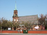
Religious sites
The village has two places of worship:- Banks Methodist Chapel situated on Chapel Lane.
- Banks Church of EnglandChurch of EnglandThe Church of England is the officially established Christian church in England and the Mother Church of the worldwide Anglican Communion. The church considers itself within the tradition of Western Christianity and dates its formal establishment principally to the mission to England by St...
St Stephens Church situated in the centre of the village on Church Road.
Leisure
Banks has one lesuire centre:- Banks Leisure Centre on Greaves Hall Avenue (formerly known as North Meols Leisure Centre) has two 7-a-side all weather football pitches, a sports hall and a fitness suite.
The Riverside Holiday Home Park situated on Southport New Road used to have a swimming pool and a fitness suite, but the company closed them in 2007. The company still operates on the site.
Public services
Other amenities in the village include:- A community centre on Hoole Lane.
- North Meols Medical Centre on Church Road.
- A care home on Church Road.
- Banks Post Office on Church Road.
- A pharmacy on Church Road.
- A children's nursery on Station Road.
Ralph's Wife's Lane
Ralph's Wife's Lane is the main road connecting Banks with CrossensCrossens
Crossens is the northernmost district of the town of Southport, Merseyside, England and part of the ancient parish of North Meols. Whilst most of the village is now within Merseyside, part of northern Crossens known as Fiddlers Ferry, is in West Lancashire...
to the south.
The name has two origins: one is that Ralph was a fisherman and was lost at sea and the other is that Ralph was a smuggler, again lost at sea. His wife's ghost is supposed to be still looking for him. It has been reported that people have seen the ghost on dark winter nights walking from by St Stephens Church to Fiddler's Ferry holding a lamp waiting for her loved one to return home. The story states that she lit a lamp every night and sat it in her window so that he knew that she was waiting for him to return home. The site of the old house now has two newer bungalows on site with the orchard from the house still at the back of them.
Sugar Stubbs Lane
Sugar Stubbs Lane is situated in Far Banks down the A565 roadA565 road
The A565 is a road in England that runs from Liverpool in Merseyside to Tarleton in Lancashire. It is a primary route linking the town of Southport to Liverpool and to Preston ....
towards Mere Brow
Mere Brow
Mere Brow is a small village in Lancashire, England, situated between Tarleton and Banks, just off the A565 road. It is 6 miles east of Southport and 10 miles south west of Preston. It is administered by the West Lancashire District Council and the Tarleton parish council...
. The road was once a small country track across the marsh but was later tarmacd up to the Farm Yard at the end of the road. In the 1980s the road was extended across the Banks Moss towards Hundred End and Tarleton
Tarleton
-Population :-Economy:As a result of soil on the former mossland, a major economic activity in Tarleton is market gardening, particularly growing salad crops....
.
The history of the road is that of many years ago the monks from Lancaster
Lancaster, Lancashire
Lancaster is the county town of Lancashire, England. It is situated on the River Lune and has a population of 45,952. Lancaster is a constituent settlement of the wider City of Lancaster, local government district which has a population of 133,914 and encompasses several outlying towns, including...
travelled by boat across the marsh to Liverpool, to do so they had to mark their way across the marsh and Douglas/Ribble Estuary by dropping the "stubbs" from the sugar canes along the way so they could find their way back. One was done so at the end of Sugar Stubbs Lane by where "Sugar Stubbs Farm" is today. The Taylor family lived there for many years and the descendants still live in the farm today. The farm buildings survive, as does the house today and a small farm shop is run from the house.
There are also four more properties down the lane today, one being the former gatehouse to Greaves Hall
Greaves Hall Hospital
Greaves Hall was a country house on the outskirts of Banks in Lancashire, England, built in a Tudorbethan style for Thomas Talbot Leyland Scarisbrick in 1900.-History:...
that has the same Mock Tudor decor to the mansion house that can be seen on the corner of the junction of the A565 road and Sugar Stubbs Lane. The old driveway up to Greaves Hall was restored in 2005 as it had become overgrown and is now a public footpath.
Events
For the last 15 years every Saturday in the summer Carboot Northwest holds a carboot sale on Ralph's Wife's Lane. This attracts many visitors from around the area. It holds a variety of stalls from bric-a-brac, confectionery and a meat auction. The carboot has numerous food stands and usually there is a large slide for children that is shaped like the Titanic. People can get to Banks Car Boot Sale via car, bike or by the number 47 bus service that passes though the village from LiverpoolLiverpool
Liverpool is a city and metropolitan borough of Merseyside, England, along the eastern side of the Mersey Estuary. It was founded as a borough in 1207 and was granted city status in 1880...
via Southport
Southport
Southport is a seaside town in the Metropolitan Borough of Sefton in Merseyside, England. During the 2001 census Southport was recorded as having a population of 90,336, making it the eleventh most populous settlement in North West England...
.
The village, like many other villages across the country, has a brass band
Brass band
A brass band is a musical ensemble generally consisting entirely of brass instruments, most often with a percussion section. Ensembles that include brass and woodwind instruments can in certain traditions also be termed brass bands , but are usually more correctly termed military bands, concert...
. Banks Brass Band was formed in 1875. The band members are from the area and play various brass instruments, such as the cornet
Cornet
The cornet is a brass instrument very similar to the trumpet, distinguished by its conical bore, compact shape, and mellower tone quality. The most common cornet is a transposing instrument in B. It is not related to the renaissance and early baroque cornett or cornetto.-History:The cornet was...
. They play all year round and across the area at various functions. The band also partakes in the yearly village street parade.
Once a year (usually in late October) Banks Methodist Primary School holds a Scarecrow
Scarecrow
A scarecrow is, essentially, a decoy, though traditionally, a human figure dressed in old clothes and placed in fields by farmers to discourage birds such as crows or sparrows from disturbing and feeding on recently cast seed and growing crops.-History:In Kojiki, the oldest surviving book in Japan...
competition in the village to celebrate Halloween
Halloween
Hallowe'en , also known as Halloween or All Hallows' Eve, is a yearly holiday observed around the world on October 31, the night before All Saints' Day...
. It was started in 2007 and it involves people (mainly children) making Scarecrows and erecting them in their front gardens for a week before the judging begins at the school. The judges choose which one is the best.
The W.I. hold meetings in the small hall on Meols Court. The hall is also used for other recreational purposes, such as bingo for the senior citizens in the area.
Outdoor life in Banks
Banks is well known in the local area for its marshland which lies on the coast of the River Ribble estuaryRibble and Alt Estuaries
The Ribble and Alt Estuaries lie on the Irish Sea coast of the counties of Lancashire and Merseyside in north-west England, and form the boundaries of a number of nature preservation schemes. -Protected area:...
. The estuary is highly regarded as the best place in the area for bird watching and attracts many visitors. The area is also a site for special scientific interest.
There are also numerous paths across the village. The old railway line that ran though the village is now a path running from Southport New Road to Rydings Lane in Far Banks. It is owned by the Environmental Agency and is open to the public, dog walkers and horse riders like all paths in the area.
Hoole Lane in the village is the starting point of a popular 10 mile cycle route that extends down the coast of Southport and ends in the village of Ainsdale
Ainsdale
Ainsdale-on-Sea is a village in the borough of Sefton, Merseyside, England, situated three miles south of Southport, of which it is a suburb. At the 2001 Census it had a population of 12,723.-Prior to 1600:...
.
Two large man made drains known as The Sluice, sometimes called the River Crossens and the Back Drain flow through Banks and are very popular with anglers.
There are two recreational grounds in Banks. One is just off Hoole Lane with main access via Schwartzman's Drive and other access via Hesketh Drive and Fleetwood Crescent, which is mostly used for cricket. The other is off Aveling Drive and was once part of the Greaves Hall grounds, but is now used by Banks football team.
There are also three children's play areas that includes slides, swings and sea-saws. One is on the recreational ground on Schwartzman's Drive. Another is on the Redrow estate next to the site where the Greaves Hall Mansion stood, and the other is on the Lancaster Gate cul-de-sac at the end of Lancaster Drive.
Media
Even though Banks does not have any media activity, the village shares media from the nearby town of SouthportSouthport
Southport is a seaside town in the Metropolitan Borough of Sefton in Merseyside, England. During the 2001 census Southport was recorded as having a population of 90,336, making it the eleventh most populous settlement in North West England...
.
Printed press
Most of the residents of Banks gets two weekly free newspapers delivered to their door on Wednesday: The Southport Midweek Visiter and the independent Southport Champion.Also the village shops sells the Southport Visiter issued on a Friday.
The Ormskirk and West Lancashire Advertiser is also sold in the area as well as the magazine Lancashire Life
Lancashire Life
Lancashire Life is a British Regional magazine, first published in 1947, devoted to the English county palatine of Lancashire. The magazine covers lifestyle topics including motoring, property, food, art and everyday life in the county.-Circulation:...
.
Radio
Banks is close enough to Southport to receive the local radio station called Dune FMDune FM
Dune 107.9 is a radio channel which broadcasts from Southport, covering the town and the surrounding borough of Sefton as well as a large part of neighbouring West Lancashire.- Origins :...
, which is based in Southport.
Other radio stations that are based elsewhere in the reigon are also popular in the area, such as Rock FM that is based in Preston.
Because the village is on the border of Merseyside
Merseyside
Merseyside is a metropolitan county in North West England, with a population of 1,365,900. It encompasses the metropolitan area centred on both banks of the lower reaches of the Mersey Estuary, and comprises five metropolitan boroughs: Knowsley, St Helens, Sefton, Wirral, and the city of Liverpool...
and in Lancashire
Lancashire
Lancashire is a non-metropolitan county of historic origin in the North West of England. It takes its name from the city of Lancaster, and is sometimes known as the County of Lancaster. Although Lancaster is still considered to be the county town, Lancashire County Council is based in Preston...
, the village picks up good signals from both BBC Radio Merseyside
BBC Radio Merseyside
BBC Radio Merseyside is the BBC Local Radio service for the English metropolitan county of Merseyside and north Cheshire. It was the third BBC local radio station to launch on 22 November 1967 initially serving the south west of historic Lancashire....
and BBC Radio Lancashire
BBC Radio Lancashire
BBC Radio Lancashire is the BBC Local Radio service for the county of Lancashire, in North West England. It began as BBC Radio Blackburn on 26 January 1971 on 96.4FM, then adding 854 kHz AM in 1972 and changing to its current name on 4 July 1981...
.
Growth
Over the last couple of decades Banks has significantly increased its size and population. More housing and facilities have been constructed, particularly the Redrow housing estate which is situated on the former grounds of Greaves HallGreaves Hall Hospital
Greaves Hall was a country house on the outskirts of Banks in Lancashire, England, built in a Tudorbethan style for Thomas Talbot Leyland Scarisbrick in 1900.-History:...
. Since Greaves Hall was demolished in August 2009 there are plans to use the site for further residential development. There are already new housing being built east of the former nurse's accommodation on Aveling Drive.
The increasing size brings problems as in recent years concerns have aroused that the area floods during long, heavy spells of rain, due to extra surface water from poor drainage. The local council has addressed this problem and works closely with new developments.
According to a 2001 census, the population of Banks was 3,792 and it is predicted that when the new census is conducted in 2011 the population will rise to over 5,000.