
West Lancashire
Encyclopedia
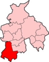
West Lancashire is a non-metropolitan district
with the status of a borough
in Lancashire
, England
. Its council is based in Ormskirk
. The other town in the borough is Skelmersdale
.
The district was formed in 1974 under the Local Government Act 1972
, as a merger of Ormskirk
and Skelmersdale and Holland
urban district
s along with part of West Lancashire Rural District
and part of Wigan Rural District
.
has had a majority. As of the 2010 election
the council is composed of the following councillor
s:-
on December 10, 2008, an Order in Council was made for the issuing of a royal charter
granting borough status
to the district of West Lancashire. The charter came into effect on 20 May 2009.
(including the village of Westhead) and Skelmersdale
are unparished area
s.
, France
Erkrath
, Germany
Non-metropolitan district
Non-metropolitan districts, or colloquially shire districts, are a type of local government district in England. As created, they are sub-divisions of non-metropolitan counties in a so-called "two-tier" arrangement...
with the status of a borough
Borough status in the United Kingdom
Borough status in the United Kingdom is granted by royal charter to local government districts in England, Wales and Northern Ireland. The status is purely honorary, and does not give any additional powers to the council or inhabitants of the district...
in Lancashire
Lancashire
Lancashire is a non-metropolitan county of historic origin in the North West of England. It takes its name from the city of Lancaster, and is sometimes known as the County of Lancaster. Although Lancaster is still considered to be the county town, Lancashire County Council is based in Preston...
, England
England
England is a country that is part of the United Kingdom. It shares land borders with Scotland to the north and Wales to the west; the Irish Sea is to the north west, the Celtic Sea to the south west, with the North Sea to the east and the English Channel to the south separating it from continental...
. Its council is based in Ormskirk
Ormskirk
Ormskirk is a market town in West Lancashire, England. It is situated north of Liverpool city centre, northwest of St Helens, southeast of Southport and southwest of Preston.-Geography and administration:...
. The other town in the borough is Skelmersdale
Skelmersdale
Skelmersdale is a town in West Lancashire, England. It lies on high-ground on the River Tawd, to the west of Wigan, to the northeast of Liverpool, south-southwest of Preston. As of 2006, Skelmersdale had a population of 38,813, down from 41,000 in 2004. The town is known locally as Skem.The...
.
The district was formed in 1974 under the Local Government Act 1972
Local Government Act 1972
The Local Government Act 1972 is an Act of Parliament in the United Kingdom that reformed local government in England and Wales on 1 April 1974....
, as a merger of Ormskirk
Ormskirk Urban District
Ormskirk was an urban district in the county of Lancashire from 1894 to 1974. It was named after the town of Ormskirk, which constituted its main settlement....
and Skelmersdale and Holland
Skelmersdale and Holland
Skelmersdale and Holland was an urban district in Lancashire, England from 1968 to 1974. It was created by the merger of Skelmersdale and Upholland urban districts. In 1974 it was itself merged into the new non-metropolitan district of West Lancashire, under the Local Government Act 1972....
urban district
Urban district
In the England, Wales and Ireland, an urban district was a type of local government district that covered an urbanised area. Urban districts had an elected Urban District Council , which shared local government responsibilities with a county council....
s along with part of West Lancashire Rural District
West Lancashire Rural District
West Lancashire was a rural district from 1894 to 1974 in Lancashire, England. It was created with other rural districts in 1894, based on the Ormskirk rural sanitary district...
and part of Wigan Rural District
Wigan Rural District
Wigan was a rural district in Lancashire, England from 1894 to 1974. It comprised an area to the north, but did not include the town Wigan.The district was created by the Local Government Act 1894 as the successor to the Wigan Rural Sanitary District....
.
Local government
Elections to the borough council are held in three out of every four years, with one third of the 54 seats on the council being elected at each election. Since gaining control of the council in the 2002 election the Conservative partyConservative Party (UK)
The Conservative Party, formally the Conservative and Unionist Party, is a centre-right political party in the United Kingdom that adheres to the philosophies of conservatism and British unionism. It is the largest political party in the UK, and is currently the largest single party in the House...
has had a majority. As of the 2010 election
West Lancashire Council election, 2010
The 2010 West Lancashire Council election took place on 6 May 2010 to elect members of West Lancashire Borough Council in Lancashire, England. One third of the council was up for election and the Conservative party stayed in overall control of the council....
the council is composed of the following councillor
Councillor
A councillor or councilor is a member of a local government council, such as a city council.Often in the United States, the title is councilman or councilwoman.-United Kingdom:...
s:-
| Year | Conservatives Conservative Party (UK) The Conservative Party, formally the Conservative and Unionist Party, is a centre-right political party in the United Kingdom that adheres to the philosophies of conservatism and British unionism. It is the largest political party in the UK, and is currently the largest single party in the House... | Labour Labour Party (UK) The Labour Party is a centre-left democratic socialist party in the United Kingdom. It surpassed the Liberal Party in general elections during the early 1920s, forming minority governments under Ramsay MacDonald in 1924 and 1929-1931. The party was in a wartime coalition from 1940 to 1945, after... | Independent Independent (politician) In politics, an independent or non-party politician is an individual not affiliated to any political party. Independents may hold a centrist viewpoint between those of major political parties, a viewpoint more extreme than any major party, or they may have a viewpoint based on issues that they do... |
|---|---|---|---|
| 2010 | 31 | 22 | 1 |
Borough status
At a meeting of the Privy CouncilPrivy council
A privy council is a body that advises the head of state of a nation, typically, but not always, in the context of a monarchic government. The word "privy" means "private" or "secret"; thus, a privy council was originally a committee of the monarch's closest advisors to give confidential advice on...
on December 10, 2008, an Order in Council was made for the issuing of a royal charter
Royal Charter
A royal charter is a formal document issued by a monarch as letters patent, granting a right or power to an individual or a body corporate. They were, and are still, used to establish significant organizations such as cities or universities. Charters should be distinguished from warrants and...
granting borough status
Borough status in the United Kingdom
Borough status in the United Kingdom is granted by royal charter to local government districts in England, Wales and Northern Ireland. The status is purely honorary, and does not give any additional powers to the council or inhabitants of the district...
to the district of West Lancashire. The charter came into effect on 20 May 2009.
Unparished towns
The main towns of OrmskirkOrmskirk
Ormskirk is a market town in West Lancashire, England. It is situated north of Liverpool city centre, northwest of St Helens, southeast of Southport and southwest of Preston.-Geography and administration:...
(including the village of Westhead) and Skelmersdale
Skelmersdale
Skelmersdale is a town in West Lancashire, England. It lies on high-ground on the River Tawd, to the west of Wigan, to the northeast of Liverpool, south-southwest of Preston. As of 2006, Skelmersdale had a population of 38,813, down from 41,000 in 2004. The town is known locally as Skem.The...
are unparished area
Unparished area
In England, an unparished area is an area that is not covered by a civil parish. Most urbanised districts of England are either entirely or partly unparished. Many towns and some cities in otherwise rural districts are also unparished areas and therefore no longer have a town council or city...
s.
Parish councils
- AughtonAughton, LancashireAughton is a village and civil parish within the West Lancashire district of Lancashire, England, situated between Ormskirk in Lancashire and Maghull in Merseyside. It is a residential area with tree lined roads being found in all parts of the parish and with an area of 1,658 hectares...
- BickerstaffeBickerstaffeBickerstaffe is a village and civil parish in the West Lancashire district of Lancashire, England. According to the 2001 Census the population of the civil parish was 1,196, although the population of the electoral ward was slightly greater at 2,013....
- BurscoughBurscoughBurscough is a village and civil parish within West Lancashire in North West England, to the north of both Ormskirk and Skelmersdale.-Growth:...
- DaltonDalton, LancashireDalton is a village and civil parish in West Lancashire, near Skelmersdale and south of the River Douglas. Dalton was listed in the Domesday Book, and soon after the Norman conquest became part of the Barony of Manchester. It remained part of the Manchester fee as late as 1733...
- DownhollandDownhollandDownholland is a civil parish in Lancashire, England on the West Lancashire Coastal Plain. The area contains several villages including Haskayne, Barton and Downholland Cross, and the Leeds and Liverpool Canal and the A5147....
- Great AltcarGreat AltcarGreat Altcar is a village and civil parish in West Lancashire, close to Formby on the West Lancashire Coastal Plain. The name Altcar is Norse meaning "marsh by the Alt". The church of St Michael and All Angels is a timber framed structure dating from 1879....
- HalsallHalsallHalsall is a village and civil parish in West Lancashire, England, located close to Ormskirk on the A5147 and Leeds and Liverpool Canal. The parish has a population of 1,921 and covers an area of 28.31 square kilometres...
- Hesketh-with-Becconsall
- Hilldale
- LathomLathomLathom is a village and civil parish in Lancashire, England, about 5 km northeast of Ormskirk. It is in the district of West Lancashire, and with the parish of Newburgh forms part of Newburgh ward...
- Lathom South
- NewburghNewburgh, LancashireNewburgh is a rural village and civil parish in Lancashire, England.Newburgh is located about five miles from Ormskirk. Its history can be traced back to 1304 when a licence was granted to start a weekly market. The village has a conservation area at its centre and includes many historic ...
- North MeolsNorth MeolsNorth Meols is a civil parish in the West Lancashire district of Lancashire, England. The parish covers the village of Banks and the hamlet of Hundred End...
- ParboldParboldParbold is a large commuter village and civil parish in the county of Lancashire, England.-Local government:The 83 hectares of the 'urban settlement' of Parbold has a population of 2,700. This settlement forms part of the larger Parbold ward Parbold is a large commuter village and civil parish in...
- RuffordRufford, Lancashire-Population :-Economy:The village is largely rural with little or no industry. The farmland is grade one agricultural land. In the early 20th century the village was described as "one of the prettiest in South Lancashire" and was a destination for day trips from neighbouring towns...
- ScarisbrickScarisbrickScarisbrick is a village and civil parish in West Lancashire, England. It is spread out along the A570 so there is no real village centre, though the junction with the A5147 is close to the geographic centre...
- SimonswoodSimonswoodSimonswood is a civil parish in the West Lancashire district of Lancashire, England. At the 2001 Census, the population was 130.It was originally a township associated with the parish of Walton on the Hill, and became a separate civil parish in 1866....
- TarletonTarleton-Population :-Economy:As a result of soil on the former mossland, a major economic activity in Tarleton is market gardening, particularly growing salad crops....
- UphollandUphollandUpholland is a civil parish and village in West Lancashire, England. It is situated approximately 3 miles east of Skelmersdale, also in West Lancashire, and 4½ miles west of Wigan in Greater Manchester.-Geography:...
- WrightingtonWrightingtonWrightington is a civil parish in West Lancashire, England, with an area of 3,915½ acres. The surface is hilly, rising to over 400 ft. at Harrock on the border of Parbold, and then falling to the north, north-east and south-east. On the southern border, the boundary at Appley Bridge touches...
Twin towns
West Lancashire is twinned with: Cergy-PontoiseCergy-Pontoise
Cergy-Pontoise is a new town in France, in the Val d'Oise département, northwest of Paris on the Oise River. It owes its name to two of the communes that it covers, Cergy and Pontoise....
, France
France
The French Republic , The French Republic , The French Republic , (commonly known as France , is a unitary semi-presidential republic in Western Europe with several overseas territories and islands located on other continents and in the Indian, Pacific, and Atlantic oceans. Metropolitan France...
Erkrath
Erkrath
Erkrath is a town in the district of Mettmann, in North Rhine-Westphalia, Germany-Geography:Erkrath is situated on the Düssel river, directly east of Düsseldorf and west of Wuppertal, close to the famous Neandertal....
, Germany
Germany
Germany , officially the Federal Republic of Germany , is a federal parliamentary republic in Europe. The country consists of 16 states while the capital and largest city is Berlin. Germany covers an area of 357,021 km2 and has a largely temperate seasonal climate...