

Bakker-Schut Plan
Encyclopedia
At the end of World War II
, plans were made in the Netherlands
to annex German territory as compensation for the damages caused by the war. In October 1945, the Dutch state asked Germany
for 25 billion guilder
s in reparations
, but in February 1945 it had already been established at the Yalta Conference
that reparations would not be given in monetary form. The plan which was worked out in most detail was the one made by Frits Bakker-Schut, and hence became known as the Bakker-Schut Plan.
In its most ambitious form, this plan included the cities of Cologne
, Aachen
, Münster
and Osnabrück
, and would have enlarged the country by 30 to 50 percent. The local population had to be either deported, or, when still speaking the original Low German
dialects, Dutchified
. The plan was largely dropped after U.S. dismissal of it. Eventually, an area of a total size of 69 km2 was allocated to the Netherlands. Almost all of this was returned to West Germany
in 1963 after Germany paid the Netherlands 280 million German marks.
Many Germans living in the Netherlands were however declared 'enemy subjects' after World War II ended and put into a concentration camp in an operation called Black Tulip. A total of 3,691 Germans were ultimately deported. The UK responded by expelling 100,000 Dutch citizens living in occupied Germany.
Eelco Nicolaas van Kleffens
, put forth their own ideas regarding annexation in these publications. Opinions varied widely as to how much territory should be annexed. Some people only wanted a few border corrections, others drew the new border past Hamburg
.
The proponents of annexation joined in several local committees. On June 19, 1945, the Hague
committee to examine the question of Dutch territorial expansion was founded. During a meeting of this committee on July 12, 1945, it was decided to split the committee in the Study Group Territorial Expansion (Studiegroep Gebiedsuitbreiding), chaired by Ph.J. Idenburg, and the Action Committee (Comité van Actie), which had as its primary function the education of the Dutch population about the expansion plans. Six days later, the latter committee was renamed the Dutch Committee for Territorial Expansion. It was chaired by former Finance minister
Johannes van den Broek
. On August 25, 1945, Minister Van Kleffens founded the State Commission for the Study of the Annexation Question, which was charged with writing a final report regarding the annexation question by May 1946.
The Study Group Territorial Expansion set up many groups that reported about their findings. The final judgment of the State Commission would be largely based on the results of this study group. The Dutch Committee for Territorial Expansion published on the progress of the study group by giving out brochures and giving lectures. The annexation question however led to intense discussions, which lead certain groups to go their own way and among other things found the Annexation Committee of the Foundation for Agriculture.
-Osnabrück
-Hamm
-Wesel
would be added to the Netherlands, as well as the land east of Limburg
, where the border followed the Rhine until close to Cologne
, then diverging towards Aachen
in the west. In this A Variation of the plan, among others the large cities of Aachen, Cologne, Münster
, Oldenburg
and Osnabrück were annexed. Bakker Schut called this the Weser border
and ended his writings with the slogan Nederland's grens kome aan de Wezer (The border of the Netherlands be at the Weser). In a smaller plan B, the west-Rhineland
cities Cologne, Mönchengladbach
and Neuss
were not annexed. In a third option, plan C, the proposed annexation was much smaller. It included an area west of Varel
, the entire Emsland
, and the area around Wesel
until near the Duchy of Cleves
.
 The areas which were to be annexed according to the Bakker Schut Plan were the following then existing districts and cities.
, the Duchy of Jülich
and Bentheim
) used to be Dutch speaking until being Germanized under Prussian hegemony, and the Dutch language and culture had a large influence in East Frisia
, Bakker Schut was aware that it was difficult to claim this area purely on historical grounds. Hence, he justified the annexation using arguments like increased power and greater security for the Dutch state. He furthermore considered the annexation as compensation for war damages and as a part of the population policy to be followed. Contrary to what might be expected, after an inventory he considered the natural resources of the territory to be annexed as insufficiently important to motivate annexation. In his view, even a transfer of the entire Ruhr Area
would not be sufficient to pay for the damages.
, for instance if they had made efforts for the Dutch state during the war, if they usually spoke Low Saxon instead of High German, if they had no family members up to the second degree that lived in Germany, or if they wished to become Dutch.
(later Prime Minister
) was dead set against it. Generally, socialists were against annexation and Protestants and liberals were reluctant. The Catholics saw advantages in the territorial expansion, mainly as a method to give the farmers near the border more room. Nevertheless, Dutch churches objected to the proposed mass extradition, because in their eyes the German population could not be found guilty of the crimes of the Nazis during World War II. Prime Minister Wim Schermerhorn was also not in favor of annexing German territory, but Queen
Wilhelmina
, an energetic supporter of the annexation plan, strongly urged him to start negotiating on this with the Allies
. In 1946, in the name of the Dutch government, he officially claimed 4,980 km2 of German territory, which was not even half of the area envisioned by Van Kleffens. The Dutch-German border would be drawn from Vaals
via Winterswijk
to the Ems River, so that 550,000 Germans would live inside the Dutch national borders.
, on the grounds that Germany already contained 14,000,000 refugees from the annexations in the east, and that the remaining territory could not handle more refugees. Furthermore, the allies (in particular the Americans) considered it vital to have a stable West-Germany in view of the coming Cold War
. All suggested annexations of the Morgenthau Plan
were ignored as a result of new political developments.
At a conference of foreign ministers of the western allied occupation forces in London (January 14 until February 25, 1947), the Dutch government (Cabinet Beel I) claimed an area of 1,840 km2. This claim included apart from the island Borkum
large parts of the Emsland, Bentheim, the cities Ahaus
, Rees
, Kleve
, Erkelenz
, Geilenkirchen
and Heinsberg
and the areas around these cities.
In 1946, about 160,000 people lived in this area, of which more than 90% spoke German. This plan was a very simplified version of the C-variation of the Bakker Schut Plan. The KVP
considered this proposal much too small, while the CPN
rejected any kind of reparations in the form of territorial expansion.
The London conference of April 23, 1949, only permitted some less far-reaching border modifications. At 12 o'clock of the very same day, Dutch troops occupied an area of 69 km2, the largest parts of which were Elten
(near Emmerich am Rhein) and Selfkant
. Many other small border corrections were executed, mostly in the vicinity of Arnhem
and Dinxperlo
. At that time, these areas were inhabited by a total of almost 10,000 people.
.
The territory was returned to Germany on August 1, 1963, except one small hill (about 3 km²) near Wyler
village, called Duivelsberg/Wylerberg (link to Dutch wikipedia) which was annexed by Netherlands.
World War II
World War II, or the Second World War , was a global conflict lasting from 1939 to 1945, involving most of the world's nations—including all of the great powers—eventually forming two opposing military alliances: the Allies and the Axis...
, plans were made in the Netherlands
Netherlands
The Netherlands is a constituent country of the Kingdom of the Netherlands, located mainly in North-West Europe and with several islands in the Caribbean. Mainland Netherlands borders the North Sea to the north and west, Belgium to the south, and Germany to the east, and shares maritime borders...
to annex German territory as compensation for the damages caused by the war. In October 1945, the Dutch state asked Germany
Germany
Germany , officially the Federal Republic of Germany , is a federal parliamentary republic in Europe. The country consists of 16 states while the capital and largest city is Berlin. Germany covers an area of 357,021 km2 and has a largely temperate seasonal climate...
for 25 billion guilder
Guilder
Guilder is the English translation of the Dutch gulden — from Old Dutch for 'golden'. The guilder originated as a gold coin but has been a common name for a silver or base metal coin for some centuries...
s in reparations
War reparations
War reparations are payments intended to cover damage or injury during a war. Generally, the term war reparations refers to money or goods changing hands, rather than such property transfers as the annexation of land.- History :...
, but in February 1945 it had already been established at the Yalta Conference
Yalta Conference
The Yalta Conference, sometimes called the Crimea Conference and codenamed the Argonaut Conference, held February 4–11, 1945, was the wartime meeting of the heads of government of the United States, the United Kingdom, and the Soviet Union, represented by President Franklin D...
that reparations would not be given in monetary form. The plan which was worked out in most detail was the one made by Frits Bakker-Schut, and hence became known as the Bakker-Schut Plan.
In its most ambitious form, this plan included the cities of Cologne
Cologne
Cologne is Germany's fourth-largest city , and is the largest city both in the Germany Federal State of North Rhine-Westphalia and within the Rhine-Ruhr Metropolitan Area, one of the major European metropolitan areas with more than ten million inhabitants.Cologne is located on both sides of the...
, Aachen
Aachen
Aachen has historically been a spa town in North Rhine-Westphalia, Germany. Aachen was a favoured residence of Charlemagne, and the place of coronation of the Kings of Germany. Geographically, Aachen is the westernmost town of Germany, located along its borders with Belgium and the Netherlands, ...
, Münster
Münster
Münster is an independent city in North Rhine-Westphalia, Germany. It is located in the northern part of the state and is considered to be the cultural centre of the Westphalia region. It is also capital of the local government region Münsterland...
and Osnabrück
Osnabrück
Osnabrück is a city in Lower Saxony, Germany, some 80 km NNE of Dortmund, 45 km NE of Münster, and some 100 km due west of Hanover. It lies in a valley penned between the Wiehen Hills and the northern tip of the Teutoburg Forest...
, and would have enlarged the country by 30 to 50 percent. The local population had to be either deported, or, when still speaking the original Low German
Low German
Low German or Low Saxon is an Ingvaeonic West Germanic language spoken mainly in northern Germany and the eastern part of the Netherlands...
dialects, Dutchified
Batavianization
Batavianization or Batavianisation also known as Dutchification and; historically, as Belgianization, is the spread of the Dutch language, people and/or culture either by force or assimilation...
. The plan was largely dropped after U.S. dismissal of it. Eventually, an area of a total size of 69 km2 was allocated to the Netherlands. Almost all of this was returned to West Germany
West Germany
West Germany is the common English, but not official, name for the Federal Republic of Germany or FRG in the period between its creation in May 1949 to German reunification on 3 October 1990....
in 1963 after Germany paid the Netherlands 280 million German marks.
Many Germans living in the Netherlands were however declared 'enemy subjects' after World War II ended and put into a concentration camp in an operation called Black Tulip. A total of 3,691 Germans were ultimately deported. The UK responded by expelling 100,000 Dutch citizens living in occupied Germany.
Liberation
In the first year following the liberation of the Netherlands in May 1945, dozens of pamphlets and brochures were published that propagated annexation of territory of the former German Reich, preferably without the accompanying German population. Several highly-placed persons, including then Foreign MinisterForeign minister
A Minister of Foreign Affairs, or foreign minister, is a cabinet minister who helps form the foreign policy of a sovereign state. The foreign minister is often regarded as the most senior ministerial position below that of the head of government . It is often granted to the deputy prime minister in...
Eelco Nicolaas van Kleffens
Eelco van Kleffens
Eelco Nicolaas van Kleffens was a politician and diplomat of The Netherlands.Eelco van Kleffens descended from an old Frisian family of public servants....
, put forth their own ideas regarding annexation in these publications. Opinions varied widely as to how much territory should be annexed. Some people only wanted a few border corrections, others drew the new border past Hamburg
Hamburg
-History:The first historic name for the city was, according to Claudius Ptolemy's reports, Treva.But the city takes its modern name, Hamburg, from the first permanent building on the site, a castle whose construction was ordered by the Emperor Charlemagne in AD 808...
.
The proponents of annexation joined in several local committees. On June 19, 1945, the Hague
The Hague
The Hague is the capital city of the province of South Holland in the Netherlands. With a population of 500,000 inhabitants , it is the third largest city of the Netherlands, after Amsterdam and Rotterdam...
committee to examine the question of Dutch territorial expansion was founded. During a meeting of this committee on July 12, 1945, it was decided to split the committee in the Study Group Territorial Expansion (Studiegroep Gebiedsuitbreiding), chaired by Ph.J. Idenburg, and the Action Committee (Comité van Actie), which had as its primary function the education of the Dutch population about the expansion plans. Six days later, the latter committee was renamed the Dutch Committee for Territorial Expansion. It was chaired by former Finance minister
Finance minister
The finance minister is a cabinet position in a government.A minister of finance has many different jobs in a government. He or she helps form the government budget, stimulate the economy, and control finances...
Johannes van den Broek
Johannes van den Broek
Johannes Hendrik van den Broek, was a Dutch architect influential in the rebuilding of Rotterdam after World War II....
. On August 25, 1945, Minister Van Kleffens founded the State Commission for the Study of the Annexation Question, which was charged with writing a final report regarding the annexation question by May 1946.
The Study Group Territorial Expansion set up many groups that reported about their findings. The final judgment of the State Commission would be largely based on the results of this study group. The Dutch Committee for Territorial Expansion published on the progress of the study group by giving out brochures and giving lectures. The annexation question however led to intense discussions, which lead certain groups to go their own way and among other things found the Annexation Committee of the Foundation for Agriculture.
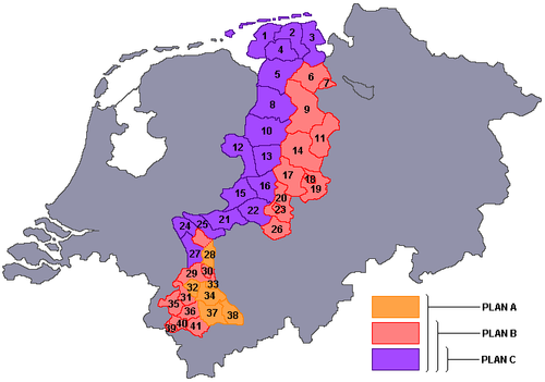
Bakker Schut Plan
Bakker Schut was the president of the National service for the National Plan, secretary of the Dutch Committee for Territorial Expansion, and a member of the State Commission for the Study of the Annexation Question and of the Study Group Territorial Expansion. In his expansion plan, he suggested to annex a large part of northwestern Germany. All the land west of the line WilhelmshavenWilhelmshaven
Wilhelmshaven is a coastal town in Lower Saxony, Germany. It is situated on the western side of the Jade Bight, a bay of the North Sea.-History:...
-Osnabrück
Osnabrück
Osnabrück is a city in Lower Saxony, Germany, some 80 km NNE of Dortmund, 45 km NE of Münster, and some 100 km due west of Hanover. It lies in a valley penned between the Wiehen Hills and the northern tip of the Teutoburg Forest...
-Hamm
Hamm
Hamm is a city in North Rhine-Westphalia , Germany. It is located in the northeastern part of the Ruhr area. As of December 2003 its population was 180,849. The city is situated between the A1 motorway and A2 motorway...
-Wesel
Wesel
Wesel is a city in North Rhine-Westphalia, Germany. It is the capital of the Wesel district.-Division of the town:Suburbs of Wesel include Lackhausen, Obrighoven, Ginderich, Feldmark,Fusternberg, Büderich, Flüren and Blumenkamp.-History:...
would be added to the Netherlands, as well as the land east of Limburg
Limburg (Netherlands)
Limburg is the southernmost of the twelve provinces of the Netherlands. It is located in the southeastern part of the country and bordered by the province of Gelderland to the north, Germany to the east, Belgium to the south and part of the west, andthe Dutch province of North Brabant partly to...
, where the border followed the Rhine until close to Cologne
Cologne
Cologne is Germany's fourth-largest city , and is the largest city both in the Germany Federal State of North Rhine-Westphalia and within the Rhine-Ruhr Metropolitan Area, one of the major European metropolitan areas with more than ten million inhabitants.Cologne is located on both sides of the...
, then diverging towards Aachen
Aachen
Aachen has historically been a spa town in North Rhine-Westphalia, Germany. Aachen was a favoured residence of Charlemagne, and the place of coronation of the Kings of Germany. Geographically, Aachen is the westernmost town of Germany, located along its borders with Belgium and the Netherlands, ...
in the west. In this A Variation of the plan, among others the large cities of Aachen, Cologne, Münster
Münster
Münster is an independent city in North Rhine-Westphalia, Germany. It is located in the northern part of the state and is considered to be the cultural centre of the Westphalia region. It is also capital of the local government region Münsterland...
, Oldenburg
Oldenburg
Oldenburg is an independent city in Lower Saxony, Germany. It is situated in the western part of the state between the cities of Bremen and Groningen, Netherlands, at the Hunte river. It has a population of 160,279 which makes it the fourth biggest city in Lower Saxony after Hanover, Braunschweig...
and Osnabrück were annexed. Bakker Schut called this the Weser border
Weser River
The Weser is a river in north-western Germany. Formed at Hann. Münden by the Fulda and Werra, it flows through Lower Saxony, then reaching the historic port city of Bremen before emptying into the North Sea 50 km further north at Bremerhaven, which is also a seaport...
and ended his writings with the slogan Nederland's grens kome aan de Wezer (The border of the Netherlands be at the Weser). In a smaller plan B, the west-Rhineland
Rhineland
Historically, the Rhinelands refers to a loosely-defined region embracing the land on either bank of the River Rhine in central Europe....
cities Cologne, Mönchengladbach
Mönchengladbach
Mönchengladbach , formerly known as Münchengladbach, is a city in North Rhine-Westphalia, Germany. It is located west of the Rhine half way between Düsseldorf and the Dutch border....
and Neuss
Neuss
Neuss is a city in North Rhine-Westphalia, Germany. It is located on the west bank of the Rhine opposite Düsseldorf. Neuss is the largest city within the Rhein-Kreis Neuss district and owes its prosperity to its location at the crossing of historic and modern trade routes. It is primarily known...
were not annexed. In a third option, plan C, the proposed annexation was much smaller. It included an area west of Varel
Varel
Varel is a town in the district of Friesland, in Lower Saxony, Germany. It is situated near the Jade River and the Jade Bight, approx. 15 km south of Wilhelmshaven, and 30 km north of Oldenburg.- Notable natives :...
, the entire Emsland
Emsland
Landkreis Emsland is a district in Lower Saxony, Germany named after the river Ems. It is bounded by the districts of Leer, Cloppenburg and Osnabrück, the state of North Rhine-Westphalia , the district of Bentheim and the Netherlands .- History :For a long time the region of the Emsland was...
, and the area around Wesel
Wesel
Wesel is a city in North Rhine-Westphalia, Germany. It is the capital of the Wesel district.-Division of the town:Suburbs of Wesel include Lackhausen, Obrighoven, Ginderich, Feldmark,Fusternberg, Büderich, Flüren and Blumenkamp.-History:...
until near the Duchy of Cleves
Duchy of Cleves
The Duchy of Cleves was a State of the Holy Roman Empire. It was situated in the northern Rhineland on both sides of the Lower Rhine, around its capital Cleves and the town of Wesel, bordering the lands of the Prince-Bishopric of Münster in the east and the Duchy of Brabant in the west...
.
Areas to be annexed
| Nr | Name | A | B | C |
|---|---|---|---|---|
| 01 | Norden-Emden | X | X | X |
| 02 | Wittmund Wittmund (district) Wittmund is a Landkreis in the northwestern part of Lower Saxony, Germany. It is situated in East Frisia, on the North Sea coast. Neighboring districts are Friesland, Leer and Aurich.-Geography:... |
X | X | X |
| 03 | Jever-Varel | X | X | X |
| 04 | Aurich | X | X | X |
| 05 | Weener-Leer | X | X | X |
| 06 | Ammerland | X | X | |
| 07 | Oldenburg-Stadt | X | X | |
| 08 | Aschendorf-Hümmling | X | X | X |
| 09 | Cloppenburg-Friesoythe | X | X | |
| 10 | Meppen | X | X | X |
| 11 | Vechta | X | X | |
| 12 | Grafschaft Bentheim | X | X | X |
| 13 | Lingen | X | X | X |
| 14 | Bersenbrück | X | X | |
| 15 | Ahaus | X | X | X |
| 16 | Steinfurt | X | X | X |
| 17 | Tecklenburg | X | X | |
| 18 | Osnabrück Stadt | X | X | |
| 19 | Osnabrück Land | X | X | |
| 20 | Münsterland | X | X | |
| 21 | Borken | X | X | X |
| 22 | Coesfeld | X | X | X |
| 23 | Münster Stadt | X | X | |
| 24 | Kleve | X | X | X |
| 25 | Rees | X | X | X |
| 26 | Lüdinghausen | X | X | |
| 27 | Geldern | X | X | X |
| 28 | Moers | X | X | |
| 29 | Kempen-Krefeld | X | X | |
| 30 | Krefeld-Uerdingen | X | X | |
| 31 | Erkelenz | X | X | |
| 32 | Mönchengladbach | X | ||
| 33 | Neuss | X | ||
| 34 | Grevenbroich | X | ||
| 35 | Heinsberg-Geilenkirchen | X | X | |
| 36 | Julich | X | X | |
| 37 | Bergheim | X | ||
| 38 | Köln | X | ||
| 39 | Aachen Stadt | X | X | |
| 40 | Aachen Land | X | X | |
| 41 | Düren | X | X |
Motivation
Although parts of the territory to be claimed (amongst others the Duchy of ClevesDuchy of Cleves
The Duchy of Cleves was a State of the Holy Roman Empire. It was situated in the northern Rhineland on both sides of the Lower Rhine, around its capital Cleves and the town of Wesel, bordering the lands of the Prince-Bishopric of Münster in the east and the Duchy of Brabant in the west...
, the Duchy of Jülich
Duchy of Jülich
The Duchy of Jülich comprised a state within the Holy Roman Empire from the 11th to the 18th centuries. The duchy lay left of the Rhine river between the Electorate of Cologne in the east and the Duchy of Limburg in the west. It had territories on both sides of the river Rur, around its capital...
and Bentheim
Bentheim
County of Bentheim is a district in Lower Saxony, Germany. It is bounded by the Dutch provinces of Overijssel and Drenthe, the district of Emsland, and the districts of Steinfurt and Borken in North Rhine-Westphalia.- History :The District has roughly the same territory as the County of...
) used to be Dutch speaking until being Germanized under Prussian hegemony, and the Dutch language and culture had a large influence in East Frisia
East Frisia
East Frisia or Eastern Friesland is a coastal region in the northwest of the German federal state of Lower Saxony....
, Bakker Schut was aware that it was difficult to claim this area purely on historical grounds. Hence, he justified the annexation using arguments like increased power and greater security for the Dutch state. He furthermore considered the annexation as compensation for war damages and as a part of the population policy to be followed. Contrary to what might be expected, after an inventory he considered the natural resources of the territory to be annexed as insufficiently important to motivate annexation. In his view, even a transfer of the entire Ruhr Area
Ruhr Area
The Ruhr, by German-speaking geographers and historians more accurately called Ruhr district or Ruhr region , is an urban area in North Rhine-Westphalia, Germany. With 4435 km² and a population of some 5.2 million , it is the largest urban agglomeration in Germany...
would not be sufficient to pay for the damages.
Forced migration
A big point of discussion in Bakker Schut's expansion plan was the proposed forced migration of the original German population. Millions of Germans would have to be transferred to the remaining German territories, because it was feared that increasing the Dutch population from 9 to 11 million people could cause trouble in providing everybody with food. A pamphlet titled Oostland - Ons Land (East land - Our land) contained a complete schedule for the extradition of the population, starting with all inhabitants of municipalities with a population of at least 2,500, all former members of the NSDAP and related organizations, and all inhabitants who had settled in the area after 1933. In special cases, the inhabitants could request to be naturalizedNaturalization
Naturalization is the acquisition of citizenship and nationality by somebody who was not a citizen of that country at the time of birth....
, for instance if they had made efforts for the Dutch state during the war, if they usually spoke Low Saxon instead of High German, if they had no family members up to the second degree that lived in Germany, or if they wished to become Dutch.
Dutch names
It was also already determined which Dutch names the cities and areas in the territory to be annexed would get. For most if not all cities, an old Dutch equivalent was already available. The table below gives a small sample of the suggested name changes.| Suggested names | Original German names >- |Aken |Aachen Aachen Aachen has historically been a spa town in North Rhine-Westphalia, Germany. Aachen was a favoured residence of Charlemagne, and the place of coronation of the Kings of Germany. Geographically, Aachen is the westernmost town of Germany, located along its borders with Belgium and the Netherlands, ... |- |Emmelkamp |Emlichheim Emlichheim Emlichheim is a community in the district of Grafschaft Bentheim in Lower Saxony, Germany, roughly 20 km south of Emmen, and 25 km northwest of Nordhorn.- Geography :... |- |Emmerik |Emmerich |- |Geelkerken |Geilenkirchen Geilenkirchen Geilenkirchen is a town in the district Heinsberg, in North Rhine-Westphalia, Germany. It is situated near the border with the Netherlands, on the river Wurm, approx. 15 km north-east of Heerlen and 20 km north of Aachen.... |- |Gelderen |Geldern Geldern Geldern ) is a city in the northwest of the federal state North Rhine-Westphalia, Germany. It is part of the district of Cleves, which is part of the Düsseldorfadministrative region.-Location:... |- |Gogh |Goch Goch Goch is a town in the district of Kleve, in North Rhine-Westphalia, Germany. It is situated close to the border with the Netherlands, approx. 12 km south of Kleve, and 27 km southeast of Nijmegen.-Cultural ties:... |- |Gulik |Jülich Jülich Jülich is a town in the district of Düren, in the federal state of North Rhine-Westphalia, Germany. Jülich is well known as location of a world-famous research centre, the Forschungszentrum Jülich and as shortwave transmission site of Deutsche Welle... |- |Hoog Elten |Hoch-Elten Elten Elten is a small German town located in Northrhine-Westfalia. It has a population of around 4,500. Since 1975, it is part of the town Emmerich am Rhein. Between 1949 and 1963, Elten was part of the Netherlands . There is a substantial minority of Dutch citizens.- External links :*... |- |Jemmingen |Jemgum Jemgum Jemgum is a municipality in the Leer district, in the northwest of Lower Saxony, Germany. The area is known as Rheiderland or Reiderland . The Rheiderland is located in East Friesland.... |- |Kleef |Kleve Kleve Kleve , is a town in the Lower Rhine region of northwestern Germany near the Dutch border and the River Rhine. From the 11th century onwards, Kleve was capital of a county and later a duchy... |- |Keulen |Köln |- |Meurs |Moers Moers Moers is a German city on the left bank of the Rhine. Moers belongs to the district of Wesel... |- |Monniken-Glaabbeek |Mönchengladbach Mönchengladbach Mönchengladbach , formerly known as Münchengladbach, is a city in North Rhine-Westphalia, Germany. It is located west of the Rhine half way between Düsseldorf and the Dutch border.... |- |Munster |Münster Münster Münster is an independent city in North Rhine-Westphalia, Germany. It is located in the northern part of the state and is considered to be the cultural centre of the Westphalia region. It is also capital of the local government region Münsterland... |- |Neder-Benthem |Bad Bentheim Bad Bentheim Bad Bentheim is a town in Lower Saxony, Germany lying in the district of Grafschaft Bentheim on the borders with North Rhine-Westphalia and the Netherlands roughly 15 km south of Nordhorn and 20 km northeast of Enschede. It is also a state-recognized thermal brine and sulphur spa town,... |- |Nieuwenhuis |Neuenhaus Neuenhaus Neuenhaus is a town in the district of Grafschaft Bentheim in Lower Saxony, and is the seat of a like-named Joint Community . Neuenhaus lies on the river Vechte near the border with the Kingdom of the Netherlands and is roughly 10 km northwest of Nordhorn, and 30 km north of... |- |Noordhoorn |Nordhorn Nordhorn Nordhorn is the district seat of Grafschaft Bentheim in Lower Saxony's southwesternmost corner near the border with the Netherlands and the boundary with North Rhine-Westphalia.- Name's origin :... |- |Osnabrugge |Osnabrück Osnabrück Osnabrück is a city in Lower Saxony, Germany, some 80 km NNE of Dortmund, 45 km NE of Münster, and some 100 km due west of Hanover. It lies in a valley penned between the Wiehen Hills and the northern tip of the Teutoburg Forest... |- |Veldhuizen |Veldhausen |- |Wezel |Wesel Wesel Wesel is a city in North Rhine-Westphalia, Germany. It is the capital of the Wesel district.-Division of the town:Suburbs of Wesel include Lackhausen, Obrighoven, Ginderich, Feldmark,Fusternberg, Büderich, Flüren and Blumenkamp.-History:... |- |Zelfkant |Selfkant Selfkant Selfkant is a municipality in the Heinsberg district, in North Rhine-Westphalia, Germany. It is the most westerly municipality in Germany... |- |Zwilbroek |Zwillbrock |
|---|
Dispute
In the Dutch cabinet, a dispute about the annexation question arose. Van Kleffens promoted territorial expansion, while Minister of Social Affairs Willem DreesWillem Drees
Willem Drees was a Dutch politician of the Labour Party . He served as Prime Minister of the Netherlands from August 7, 1948 until December 22, 1958....
(later Prime Minister
Prime Minister of the Netherlands
The Prime Minister of the Netherlands is the chairman of the Council of Ministers of the Netherlands. He is the de facto head of government of the Netherlands and coordinates the policy of the government...
) was dead set against it. Generally, socialists were against annexation and Protestants and liberals were reluctant. The Catholics saw advantages in the territorial expansion, mainly as a method to give the farmers near the border more room. Nevertheless, Dutch churches objected to the proposed mass extradition, because in their eyes the German population could not be found guilty of the crimes of the Nazis during World War II. Prime Minister Wim Schermerhorn was also not in favor of annexing German territory, but Queen
Queen regnant
A queen regnant is a female monarch who reigns in her own right, in contrast to a queen consort, who is the wife of a reigning king. An empress regnant is a female monarch who reigns in her own right over an empire....
Wilhelmina
Wilhelmina of the Netherlands
Wilhelmina was Queen regnant of the Kingdom of the Netherlands from 1890 to 1948. She ruled the Netherlands for fifty-eight years, longer than any other Dutch monarch. Her reign saw World War I and World War II, the economic crisis of 1933, and the decline of the Netherlands as a major colonial...
, an energetic supporter of the annexation plan, strongly urged him to start negotiating on this with the Allies
Allies
In everyday English usage, allies are people, groups, or nations that have joined together in an association for mutual benefit or to achieve some common purpose, whether or not explicit agreement has been worked out between them...
. In 1946, in the name of the Dutch government, he officially claimed 4,980 km2 of German territory, which was not even half of the area envisioned by Van Kleffens. The Dutch-German border would be drawn from Vaals
Vaals
Vaals is a town in the extreme southeastern part of the Dutch province of Limburg, which in its turn finds itself in the southeastern part of the Netherlands....
via Winterswijk
Winterswijk
Winterswijk is a municipality and a town in the eastern Netherlands.Winterswijk is a town with a population of some 30,000 in the Achterhoek which lies in the most eastern part of the province of Gelderland in the Netherlands. It was also known as Winethereswick, Winriswic or Wenterswic...
to the Ems River, so that 550,000 Germans would live inside the Dutch national borders.
Implementation
The large scale annexation was in 1947 rejected by the Allied High CommissionAllied High Commission
The Allied High Commission was established by the United States of America, the United Kingdom, and France after the 1948 breakdown of the Allied Control Council to regulate and supervise the development of the newly established Federal Republic of Germany The Allied High Commission (also known...
, on the grounds that Germany already contained 14,000,000 refugees from the annexations in the east, and that the remaining territory could not handle more refugees. Furthermore, the allies (in particular the Americans) considered it vital to have a stable West-Germany in view of the coming Cold War
Cold War
The Cold War was the continuing state from roughly 1946 to 1991 of political conflict, military tension, proxy wars, and economic competition between the Communist World—primarily the Soviet Union and its satellite states and allies—and the powers of the Western world, primarily the United States...
. All suggested annexations of the Morgenthau Plan
Morgenthau Plan
The Morgenthau Plan, proposed by United States Secretary of the Treasury Henry Morgenthau, Jr., advocated that the Allied occupation of Germany following World War II include measures to eliminate Germany's ability to wage war.-Overview:...
were ignored as a result of new political developments.
At a conference of foreign ministers of the western allied occupation forces in London (January 14 until February 25, 1947), the Dutch government (Cabinet Beel I) claimed an area of 1,840 km2. This claim included apart from the island Borkum
Borkum
Borkum is an island and a municipality in the Leer District in Lower Saxony, northwestern Germany.-Geography:Borkum is bordered to the west by the Westerems strait , to the east by the Osterems strait, to the north by the North Sea, and to the south by the Wadden Sea...
large parts of the Emsland, Bentheim, the cities Ahaus
Ahaus
Ahaus is a municipality in the district of Borken in the state of North Rhine-Westphalia, Germany. It is located near the border with the Netherlands, lying some 20 km south-east of Enschede....
, Rees
Rees
Rees is a Welsh name that traces back to the ancient Celts known as the Britons. The surname was first recorded in Carmarthenshire, and is derived from the personal name Rhys.It may refer to one of these people:...
, Kleve
Kleve
Kleve , is a town in the Lower Rhine region of northwestern Germany near the Dutch border and the River Rhine. From the 11th century onwards, Kleve was capital of a county and later a duchy...
, Erkelenz
Erkelenz
- Geology :The Erkelenz Börde is the northernmost extent of the Jülich Börde and is formed from a loess plateau that has an average thickness of over eleven metres in this area. Beneath it are the gravels and sands of the main ice age terrace, laid down by the Rhine and the Meuse...
, Geilenkirchen
Geilenkirchen
Geilenkirchen is a town in the district Heinsberg, in North Rhine-Westphalia, Germany. It is situated near the border with the Netherlands, on the river Wurm, approx. 15 km north-east of Heerlen and 20 km north of Aachen....
and Heinsberg
Heinsberg
Heinsberg is the capital of the district Heinsberg in North Rhine-Westphalia, Germany. It is situated near the border with the Netherlands, on the river Wurm, approx...
and the areas around these cities.
In 1946, about 160,000 people lived in this area, of which more than 90% spoke German. This plan was a very simplified version of the C-variation of the Bakker Schut Plan. The KVP
Catholic People's Party
The Catholic People's Party was a Catholic Christian democratic Dutch political party. During its entire existence, the party was in government. The party is one of the precursors of the Christian Democratic Appeal.- 1945-1965 :The KVP was founded on 22 December, 1945...
considered this proposal much too small, while the CPN
Communist Party of the Netherlands
The Communist Party of the Netherlands was a Dutch communist political party. The CPN is one of the predecessors of the GreenLeft.- Foundation :...
rejected any kind of reparations in the form of territorial expansion.
The London conference of April 23, 1949, only permitted some less far-reaching border modifications. At 12 o'clock of the very same day, Dutch troops occupied an area of 69 km2, the largest parts of which were Elten
Elten
Elten is a small German town located in Northrhine-Westfalia. It has a population of around 4,500. Since 1975, it is part of the town Emmerich am Rhein. Between 1949 and 1963, Elten was part of the Netherlands . There is a substantial minority of Dutch citizens.- External links :*...
(near Emmerich am Rhein) and Selfkant
Selfkant
Selfkant is a municipality in the Heinsberg district, in North Rhine-Westphalia, Germany. It is the most westerly municipality in Germany...
. Many other small border corrections were executed, mostly in the vicinity of Arnhem
Arnhem
Arnhem is a city and municipality, situated in the eastern part of the Netherlands. It is the capital of the province of Gelderland and located near the river Nederrijn as well as near the St. Jansbeek, which was the source of the city's development. Arnhem has 146,095 residents as one of the...
and Dinxperlo
Dinxperlo
Dinxperlo is a town and former municipality in the eastern Netherlands , situated directly at the border with Germany. Since 1 January 2005, Dinxperlo is a part of the municipality of Aalten....
. At that time, these areas were inhabited by a total of almost 10,000 people.
Overview of areas annexed in 1949 (from north to south)
- Uninhabited areas (0.3 km2) between NieuweschansNieuweschansBad Nieuweschans is a town in the Dutch province of Groningen. It is located in the municipality of Oldambt, about 12 km east of Winschoten. In April 2009 the municipality of Reiderland changed the name from Nieuweschans, to promote the town as a spa...
and Ter ApelTer ApelTer Apel is a town in the municipality Vlagtwedde in the northern Netherlands, in the province Groningen in the region Westerwolde. The town lies on the stream Ruiten Aa, which has the valley that together with the Ter Apeler forest belongs to the national network of nature reserves, the... - Uninhabited areas on both sides of the Channel Almelo-Nordhorn (0.3 km2)
- Area near LosserLosser-Population centres:*Beuningen*De Lutte*Glane*Losser*Overdinkel-Losser:The oldest known reference to Losser dates from the tenth century. Originally, the village consisted of two separate parts. Both were almost completely destroyed when on 21 September 1665, troops from Münster set fire to...
, 18 inhabitants (1 km2) - Small border road near RekkenRekkenRekken is a small village in the Dutch municipality of Berkelland. It lies in the most northeast corner of the province Gelderland, about half a mile from the German border. The river Berkel enters The Netherlands east of Rekken...
south of HaaksbergenHaaksbergenHaaksbergen is a municipality and a town in the eastern Netherlands, in the province of Overijssel, in the Twente region.-External links:*... - Uninhabited area near Kotten (0.09 km2)
- Suderwick, small village bordering on Dinxperlo, 342 inhabitants (0.64 km2)
- EltenEltenElten is a small German town located in Northrhine-Westfalia. It has a population of around 4,500. Since 1975, it is part of the town Emmerich am Rhein. Between 1949 and 1963, Elten was part of the Netherlands . There is a substantial minority of Dutch citizens.- External links :*...
, small town on the Rhine, 3,235 inhabitants (19,54 km2) - Small border road near Millingen aan de RijnMillingen aan de RijnMillingen aan de Rijn is a municipality and a town in the eastern Netherlands.-External links:*...
- Duivelsberg between Beek and Wijlerberg
- Border road near MookMookMook may refer to:* Mook * Mook en Middelaar, a municipality in the Netherlands* MOOK DLE, a Japanese animation studio* "The Mook, the Chef, the Wife and Her Homer", an episode of The Simpsons cartoon TV series...
; - Uninhabited area near Ottersum (0,05 km²);
- Border road near Siebengewald, four inhabitants;
- Two areas north and south of ArcenArcenArcen is a village in the Dutch province of Limburg. In 2010, it became part of the municipality of Venlo. Previously, it had been part of the municipality of Arcen en Velden and the seat of 'het gemeentehuis' . Gemeente Arcen en VeldenIn 2001, Arcen had 1884 inhabitants...
, sixty inhabitants (0.4 and 0.41 km²) - Area near SittardSittardSittard is a city in the Dutch province of Limburg, which is the southernmost province of the Netherlands.On the east Sittard borders on Germany . It has some 48,400 inhabitants . Sittard is part of the municipality of Sittard-Geleen...
of 41,34 km² inhabited by 5,665 people (SelfkantSelfkantSelfkant is a municipality in the Heinsberg district, in North Rhine-Westphalia, Germany. It is the most westerly municipality in Germany...
); - Border road near Ubach over WormsUbach over WormsUbach over Worms is a former municipality located in the southeast of the Netherlands, in the province of Limburg. In 1982 it was incorporated into the new municipality of Landgraaf along with Schaesberg and Nieuwenhagen. The German name for this part of Landgraaf is "Waubach"...
; - Area near RimburgRimburgRimburg is a village in the Dutch province of Limburg. It is located in the municipality of Landgraaf, on the German border.Rimburg was a separate municipality until 1887, when it was merged with Ubach over Worms.-External links:*...
and KerkradeKerkradeKerkrade is a town and a municipality in the southeastern Netherlands.It is the western half of the divided region and de facto city, taken together with the eastern half, the German town of Herzogenrath...
, 130 inhabitants (0.88 km²); - Fixed some border-technical mistakes in Kerkrade
- Area near Eijgelshoven, 110 inhabitants (0,11 km²)
Return
Starting in March 1957, West Germany negotiated the return of these areas with the Netherlands. These negotiations led to an agreement made in The Hague on April 8, 1960, in which Germany agreed to pay 280 million German marks for the return of Elten, Selfkant, and Suderwick, as WiedergutmachungWiedergutmachung
The German word Wiedergutmachung after World War II refers to the reparations that the German government agreed to pay to the direct survivors of the Holocaust, and to those who were made to work as forced labour or who otherwise became victims of the Nazis.The noun Wiedergutmachung is the general...
.
The territory was returned to Germany on August 1, 1963, except one small hill (about 3 km²) near Wyler
Wyler, North Rhine-Westphalia
Wyler is a village along the Dutch/German border, 7 km SE of Nijmegen, Netherlands, and 5 km west of Kranenburg, North Rhine-Westphalia...
village, called Duivelsberg/Wylerberg (link to Dutch wikipedia) which was annexed by Netherlands.
See also
- German reparations for World War IIGerman reparations for World War IIAfter World War II, both West Germany and East Germany were obliged to pay war reparations to the Allied governments, according to the Potsdam Conference...
- Morgenthau PlanMorgenthau PlanThe Morgenthau Plan, proposed by United States Secretary of the Treasury Henry Morgenthau, Jr., advocated that the Allied occupation of Germany following World War II include measures to eliminate Germany's ability to wage war.-Overview:...
- Monnet PlanMonnet PlanThe Monnet plan was proposed by French civil servant Jean Monnet after the end of World War II. It was a reconstruction plan for France that proposed giving France control over the German coal and steel areas of the Ruhr area and Saar and using these resources to bring France to 150% of pre-war...
- Marshall PlanMarshall PlanThe Marshall Plan was the large-scale American program to aid Europe where the United States gave monetary support to help rebuild European economies after the end of World War II in order to combat the spread of Soviet communism. The plan was in operation for four years beginning in April 1948...
External links
- Interview with Perry Laukhuff, secretary of mission with U.S. Political Adviser for Germany, Berlin, 1945-49 Describes how amongst other nations the Netherlands tried to grab German territory in 1949
- 'Eisch Duitschen grond!' Comprehensive overview, in Dutch.
- International Boundary Study No. 31 – April 6, 1964 Germany – Netherlands Boundary. The Geographer Office of the Geographer Bureau of Intelligence and Research (MAP})