

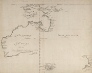
Australian places with Dutch names
Encyclopedia
Netherlands
The Netherlands is a constituent country of the Kingdom of the Netherlands, located mainly in North-West Europe and with several islands in the Caribbean. Mainland Netherlands borders the North Sea to the north and west, Belgium to the south, and Germany to the east, and shares maritime borders...
voyages of exploration
European exploration of Australia
The European exploration of Australia encompasses several waves of seafarers and land explorers. Although Australia is often loosely said to have been discovered by Royal Navy Lieutenant James Cook in 1770, he was merely one of a number of European explorers to have sighted and landed on the...
along the western, northern and southern Australian coasts. Other places were named after the early Dutch explorers by later British explorers or colonists, for instance the Australian state of Tasmania
Tasmania
Tasmania is an Australian island and state. It is south of the continent, separated by Bass Strait. The state includes the island of Tasmania—the 26th largest island in the world—and the surrounding islands. The state has a population of 507,626 , of whom almost half reside in the greater Hobart...
is named after Abel Tasman
Abel Tasman
Abel Janszoon Tasman was a Dutch seafarer, explorer, and merchant, best known for his voyages of 1642 and 1644 in the service of the VOC . His was the first known European expedition to reach the islands of Van Diemen's Land and New Zealand and to sight the Fiji islands...
. Australia itself was called New Holland
New Holland (Australia)
New Holland is a historic name for the island continent of Australia. The name was first applied to Australia in 1644 by the Dutch seafarer Abel Tasman as Nova Hollandia, naming it after the Dutch province of Holland, and remained in use for 180 years....
by the Dutch.
Northern Territory
| Dutch name | English translation | Date | Reason for naming | Coords | Notes | |
|---|---|---|---|---|---|---|
| Golf van Carpentaria | Gulf of Carpentaria Gulf of Carpentaria The Gulf of Carpentaria is a large, shallow sea enclosed on three sides by northern Australia and bounded on the north by the Arafura Sea... |
1623 | named after Pieter de Carpentier Pieter de Carpentier Pieter de Carpentier was a Dutch, or Flemish, administrator of the Dutch East India Company, and who served as Governor-General there from 1623–1627... , then Governor-General of the Dutch East Indies Dutch East Indies The Dutch East Indies was a Dutch colony that became modern Indonesia following World War II. It was formed from the nationalised colonies of the Dutch East India Company, which came under the administration of the Netherlands government in 1800.... |
13°59′S 139°00′E | Situated between the Northern Territory Northern Territory The Northern Territory is a federal territory of Australia, occupying much of the centre of the mainland continent, as well as the central northern regions... and Queensland Queensland Queensland is a state of Australia, occupying the north-eastern section of the mainland continent. It is bordered by the Northern Territory, South Australia and New South Wales to the west, south-west and south respectively. To the east, Queensland is bordered by the Coral Sea and Pacific Ocean... |
|
| Kaap Van der Lijn | Cape Vanderlin | 15°35′S 136°59′E | Actually the Sir Edward Pellew Group of Islands Sir Edward Pellew Group of Islands The Sir Edward Pellew Group of Islands is situated in the south-west corner of the Gulf of Carpentaria, off the northern coast of Australia.-History:They were named in 1802 by Matthew Flinders in honour of Sir Edward Pellew, a fellow naval officer... , the cape name is used for the northern tip of Vanderlin Island Vanderlin Island Vanderlin Island is an island in the Gulf of Carpentaria, Northern Territory, Australia. It is the largest island in the Sir Edward Pellew Group. Its area is 264 km².-See also:*List of islands of Australia... |
|||
| Kaap Van Diemen | Cape Van Diemen | 16°31′S 139°42′E | eastern cape of Mornington Island Mornington Island Mornington Island is the northern most of 22 islands that form the Wellesley Islands group. The island is located in the Gulf of Carpentaria at and is part of the Gulf Country region in the Australian state of Queensland. The Manowar and Rocky Islands Important Bird Area lies about 40 km to... in the Wellesley Islands Wellesley Islands The Wellesley Islands are a group of islands off the coast of north Queensland, Australia, in the Gulf of Carpentaria. They were named by Matthew Flinders in honour of Richard Wellesley, 1st Marquess Wellesley. The largest island in the group is Mornington Island... |
|||
| C. Maria | 14°52′S 135°44′E | An island, not a cape, now called Maria Island | ||||
| Groote Eylandt Groote Eylandt Groote Eylandt is the largest island in the Gulf of Carpentaria in northeastern Australia. It is the homeland of, and is owned by, the Anindilyakwa people who speak the isolated Anindilyakwa language).... |
"Big island" | sighted 1623, named 1644 | 14°00′S 136°35′E | |||
| Arnhems Landt | Arnhem Land Arnhem Land The Arnhem Land Region is one of the five regions of the Northern Territory of Australia. It is located in the north-eastern corner of the territory and is around 500 km from the territory capital Darwin. The region has an area of 97,000 km² which also covers the area of Kakadu National... |
The ship Arnhem which explored the area, which was named after the city of Arnhem Arnhem Arnhem is a city and municipality, situated in the eastern part of the Netherlands. It is the capital of the province of Gelderland and located near the river Nederrijn as well as near the St. Jansbeek, which was the source of the city's development. Arnhem has 146,095 residents as one of the... |
13°S 136°E | |||
| Krokodillen Eÿlandt | Crocodile Islands Crocodile Islands The Crocodile Islands are a group of islands belonging to the Northern Territory of Australia. They are located off the coast of Arnhem Land. One of the main islands in the group is Milingimbi Island, with other large islands including Mooroongga, Yabooma, Gananggaringur and Crocodile Islands... |
crocodiles Saltwater Crocodile The saltwater crocodile, also known as estuarine or Indo-Pacific crocodile, is the largest of all living reptiles... |
11°53′S 135°05′E | |||
| Van Diemen Baai | Van Diemen Gulf Van Diemen Gulf Van Diemen Gulf is a gulf between Arnhem Land, of the attached Cobourg Peninsula and Melville Island in northern Australia. It is connected to the Timor Sea in the west by the Clarence Strait , and to the Arafura Sea in the north by Dundas Strait... |
Anthony van Diemen Anthony van Diemen Anthony van Diemen , Dutch colonial governor, was born in Culemborg in the Netherlands, the son of Meeus Anthonisz van Diemen and Christina Hoevenaar. In 1616 he moved to Amsterdam, in hope of improving his fortune as a merchant; in this he failed and was declared bankrupt... |
12°S 132°E | |||
Western Australia
| Dutch name | English translation | Date | Reason for naming | Coords | Notes |
|---|---|---|---|---|---|
| Dorre Eylanden | Dorre Island | 25°03′S 113°06′E | to the north of Dirk Hartog Island Dirk Hartog Island Dirk Hartog Island is an island off the Gascoyne coast of Western Australia, within the Shark Bay World Heritage Area. It is about 80 kilometres long and between 3 and 15 kilometres wide and is Western Australia's largest and most western island. It covers an area of 620 square kilometres and is... , appears on 1697-1726 map |
||
| Dirck Hartogs Ree cap. | Dirk Hartog Island Dirk Hartog Island Dirk Hartog Island is an island off the Gascoyne coast of Western Australia, within the Shark Bay World Heritage Area. It is about 80 kilometres long and between 3 and 15 kilometres wide and is Western Australia's largest and most western island. It covers an area of 620 square kilometres and is... |
Dirk Hartog Dirk Hartog Dirk Hartog was a 17th century Dutch sailor and explorer. Dirk Hartog's expedition was the third European group to land on Australian soil. He was the first to leave behind an artifact to record his visit, the Hartog plate. His name is sometimes alternatively spelled Dirck Hartog or Dierick... |
25°50′S 113°05′E | ||
| Houtmans Abrolhos | Houtman Abrolhos Houtman Abrolhos The Houtman Abrolhos is a chain of 122 islands, and associated coral reefs, in the Indian Ocean off the west coast of Australia. Nominally located at , it lies about eighty kilometres west of Geraldton, Western Australia... |
1619 | Frederick de Houtman Frederick de Houtman Frederick de Houtman , or Frederik de Houtman, was a Dutch explorer who sailed along the Western coast of Australia en route to Batavia.-Biography:... , various published explanations for "Abrolhos" |
28°43′S 113°47′E | |
| Rottenest Eyland | Rottnest Island Rottnest Island Rottnest Island is located off the coast of Western Australia, near Fremantle. It is called Wadjemup by the Noongar people, meaning "place across the water". The island is long, and at its widest point with a total land area of . It is classified as an A Class Reserve and is managed by the... |
12/29/1696 | Quokka Quokka The Quokka , the only member of the genus Setonix, is a small macropod about the size of a domestic cat. Like other marsupials in the macropod family , the Quokka is herbivorous and mainly nocturnal... s which appeared to be rats, hence 'rat's nest' |
31°59′46"S 115°32′28"E | Named by Willem de Vlamingh Willem de Vlamingh Willem Hesselsz de Vlamingh was a Dutch sea-captain who explored the central west coast of Australia in the late 17th century.- Vlamingh and the VOC :... |
| Zwaanenrivier or Swarte Swaene-Rivier | Swan River Swan River (Western Australia) The Swan River estuary flows through the city of Perth, in the south west of Western Australia. Its lower reaches are relatively wide and deep, with few constrictions, while the upper reaches are usually quite narrow and shallow.... |
1/10/1697 | Black swans Black Swans Black Swans is a 2005 Dutch drama film.The film won a Golden Calf for best sound at the Netherlands Film Festival in 2005.-Plot:Marleen works as a volunteer in a rest home in Spain. When she meets Vince they are attracted to each other. Their passionate relationship has its ups and downs, and... |
31°56′50"S 115°54′58"E | Named by Willem de Vlamingh Willem de Vlamingh Willem Hesselsz de Vlamingh was a Dutch sea-captain who explored the central west coast of Australia in the late 17th century.- Vlamingh and the VOC :... |
| Landt van de Leeuwin | Cape Leeuwin Cape Leeuwin Cape Leeuwin is the most south-westerly mainland point of the Australian Continent, in the state of Western Australia.A few small islands and rocks, the St Alouarn Islands, extend further to the south. The nearest settlement, north of the cape, is Augusta. South-east of Cape Leeuwin, the coast... |
Leeuwin (galleon) Leeuwin (galleon) Leeuwin was a Dutch galleon that discovered and mapped some of the southwest corner of Australia in March 1622. In this way it became only the seventh European ship to sight the continent.... |
34°22′27"S 115°08′09"E | Name used for the land in the south west, now name only used for the cape. | |
| Landt van P. Nuyts | Nuytsland Nuytsland Nature Reserve Nuytsland Nature Reserve is a protected area of Western Australia in the far south eastern part of the state.Nominally located at 32° 18' S 125° 52' E, it has an area of 6,253.44 km², and takes in over 500 kilometers of coastline from Cape Pasley to Red Rocks Point. It was gazetted in 1969... |
Pieter Nuyts Pieter Nuyts Pieter Nuyts or Nuijts was a Dutch explorer, diplomat, and politician.He was part of a landmark expedition of the Dutch East India Company in 1626–27, which mapped the southern coast of Australia. He became the Dutch ambassador to Japan in 1627, and he was appointed Governor of Formosa in the same... |
32°18′S 125°52′E | ||
South Australia
| Dutch name | English translation | Date | Reason for naming | Coords | Notes |
|---|---|---|---|---|---|
| Landt van P. Nuyts | Nuytsland | 1/16/1627 | Pieter Nuyts Pieter Nuyts Pieter Nuyts or Nuijts was a Dutch explorer, diplomat, and politician.He was part of a landmark expedition of the Dutch East India Company in 1626–27, which mapped the southern coast of Australia. He became the Dutch ambassador to Japan in 1627, and he was appointed Governor of Formosa in the same... |
32°S 132°E | Nuytsland was the name used for the whole southern coast of Australia along the Great Australian Bight Great Australian Bight The Great Australian Bight is a large bight, or open bay, off the central and western portions of the southern coastline of mainland Australia.-Extent:... |
Tasmania
| Dutch name | English translation | Date | Reason for naming | Coords | Notes |
|---|---|---|---|---|---|
| Terre de Diemens | Van Diemen's Land Van Diemen's Land Van Diemen's Land was the original name used by most Europeans for the island of Tasmania, now part of Australia. The Dutch explorer Abel Tasman was the first European to land on the shores of Tasmania... |
11/24/1642 | Anthony van Diemen Anthony van Diemen Anthony van Diemen , Dutch colonial governor, was born in Culemborg in the Netherlands, the son of Meeus Anthonisz van Diemen and Christina Hoevenaar. In 1616 he moved to Amsterdam, in hope of improving his fortune as a merchant; in this he failed and was declared bankrupt... |
43°35′S 146°21′E | Now known as Tasmania Tasmania Tasmania is an Australian island and state. It is south of the continent, separated by Bass Strait. The state includes the island of Tasmania—the 26th largest island in the world—and the surrounding islands. The state has a population of 507,626 , of whom almost half reside in the greater Hobart... , after Dutch explorer Abel Tasman Abel Tasman Abel Janszoon Tasman was a Dutch seafarer, explorer, and merchant, best known for his voyages of 1642 and 1644 in the service of the VOC . His was the first known European expedition to reach the islands of Van Diemen's Land and New Zealand and to sight the Fiji islands... |
| Wits Eylanden | De Witt Island | 1642 | Johan de Witt Johan de Witt Johan de Witt, heer van Zuid- en Noord-Linschoten, Snelrewaard, Hekendorp and IJsselveere was a key figure in Dutch politics in the mid 17th century, when its flourishing sea trade in a period of globalization made the United Provinces a leading European power during the Dutch Golden Age... |
43°35′S 146°21′E | |
| Sueers eylan | Sweers island | 1642 | named after Salomon Sweers Salomon Sweers Salomon Sweers was a bookkeeper and a council for the Dutch East India Company.His younger brother was admiral Isaac Sweers employed by the Admiralty of Amsterdam.... , member of the Council of India |
||
| eylan den Maet | Maatsuyker Island Maatsuyker Island Maatsuyker Island is a lying close to the southern end of the south-western coast of Tasmania, Australia. It is part of the Maatsuyker Island Group which is included in the Southwest National Park, and the Tasmanian Wilderness World Heritage Site. It is the site of the Maatsuyker Island Lighthouse... |
12/1/1642 | named after Joan Maetsuycker Joan Maetsuycker Joan Maetsuycker was Governor-General of the Dutch East Indies from 1653 to 1678.Maetsuycker studied law in Leuven, and was a lawyer first in The Hague, and later in Amsterdam. From 1636, he lived in the Dutch East Indies... , member of the Council of India |
43°39′18"S 146°16′23"E | |
| Pedra branca | 1642 | "towards noon we passed two rocks of which the westernmost was like Pedra Branca off the coast of China" | 43°51′S 146°58′E | Name is Portuguese in origin, although named by the Dutch Tasman | |
| Boreels-eiland | Boreel Head | 11/29/1642 | Pieter Boreel, member of the Council of India | 43°14′S 148°00′E | Islands now called The Friars, Boreel Head is now the nearby cape on the south of Bruny Island |
| Storm Bay | Storm Bay Storm Bay Storm Bay is a large bay in the south-east of Tasmania, Australia. It is the entrance to the Derwent River estuary and the port of Hobart, the capital city of Tasmania.It is bordered by Bruny Island to the west and the Tasman Peninsula to the east.... |
1642 | "[Tasman] had almost reached his intended anchorage Adventure Bay Adventure Bay is a bay on Bruny Island in southeastern Tasmania. Discovered in 1773 by Tobias Furneaux, it was named after his ship, HMS Adventure. James Cook explored the region in 1777, as did William Bligh in 1788 and 1792.... when a heavy storm arose and he was driven out so far to sea that next morning he could hardly discern the land. It was from this incident that Storm Bay got its name." http://gutenberg.net.au/ebooks06/0600541h.html |
43°10′S 147°33′E | |
| Tasmans Eyl | Tasman Island | 1642 | 43°14′S 148°00′E | ||
| Fredericks Hendricks Bay | Frederick Hendrick Bay | 1642 | 42°51′S 147°58′E | nearby NE cape on Forestier Peninsula Forestier Peninsula The Forestier Peninsula is a peninsula of the Australian island state of Tasmania. Its coordinates are . It is connected to the mainland at East Bay Neck, near the town of Dunalley... still has the name Cape Frederick Hendrick, not near Frederick Henry Bay Frederick Henry Bay Frederick Henry Bay is a body of water in the southeast of Tasmania, Australia. It is located to the east of the South Arm peninsula, and west of the Tasman Peninsula. Towns on the coast of the bay include Lauderdale, Seven Mile Beach, Dodges Ferry and Primrose Sands... which is on the other side of the Tasman Peninsula Tasman Peninsula Tasman Peninsula is located around by road south-east of Hobart, at the south east corner of Tasmania, Australia.-Description:The Tasman Peninsula lies south and west of Forestier Peninsula, to which it is connected by an isthmus called Eaglehawk Neck... which he never visited. The bay he called Frederick Henry Bay is now Marion Bay Marion Bay, Tasmania Marion Bay is a large bay and a bounded locality located on the southeast coast of Tasmania, Australia. It is near Dunalley in the Municipality of Sorell... http://gutenberg.net.au/ebooks06/0600541h.html |
|
| Marias Eylandt | Maria Island Maria Island Maria Island is a mountainous island off the east coast of Tasmania. The entire island is a national park. Maria Island National Park has a total area of 115.50 km², which includes a marine area of 18.78 km² off the island's northwest coast. The island is about 20 km in length from... |
12/4/1642 | Maria Van Aelst, wife of Anthony Van Diemen | 42°37′S 148°05′E | |
| Schoute Eylandt | Schouten Island Schouten Island Schouten Island is a 28 km2 island in eastern Tasmania, Australia. It lies 1.6 kilometres south of Freycinet Peninsula and is a part of Freycinet National Park.-History:... |
12/4/1642 | Justus Schouten, member of the Council of India. | 42°18′S 148°16′E | |
| Vanderlins Eyl | Vanderlins Island | 1642 | Cornelis van der Lijn Cornelis van der Lijn Cornelis van der Lijn was Governor-General of the Dutch East Indies from 1646 until 1650.-Early career:Van der Lijn was born in Alkmaar, possibly in 1608. He went, in 1627, as Assistant to Batavia, Dutch East Indies aboard the Wapen van Hoorn. From 1632 to 18 January 1636 he was Accountant-General... , member of the Council of India |
42°13′S 148°18′E | not an island, actually Freycinet Peninsula Freycinet Peninsula Freycinet Peninsula is a large peninsula in eastern Tasmania, Australia. It is located north of Schouten Island, at . It is the site of Freycinet National Park.... . http://www.wetdawg.com/pages/touring/kayaking_freycinet/index_2_sk.php When Tasman passed it he was heading east; did not see the connection to the mainland in the north. |
Places named after the Dutch
Other places were given Dutch names by later explorers or colonists in honour of the Dutch. These include:- Duyfken Point - 12°34′S 141°35′E near WeipaWeipa, QueenslandWeipa is the largest town on the Gulf of Carpentaria coast of the Cape York Peninsula in Queensland, Australia. At the 2006 census, Weipa had a population of 2,830; the largest community on Cape York Peninsula. It exists because of the enormous bauxite deposits along the coast...
where Willem JanszoonWillem JanszoonWillem Janszoon , Dutch navigator and colonial governor, is probably the first European known to have seen the coast of Australia. His name is sometimes abbreviated to Willem Jansz....
first sighted the Australian coast in 1606.
- TasmaniaTasmaniaTasmania is an Australian island and state. It is south of the continent, separated by Bass Strait. The state includes the island of Tasmania—the 26th largest island in the world—and the surrounding islands. The state has a population of 507,626 , of whom almost half reside in the greater Hobart...
- Australian stateStates and territories of AustraliaThe Commonwealth of Australia is a union of six states and various territories. The Australian mainland is made up of five states and three territories, with the sixth state of Tasmania being made up of islands. In addition there are six island territories, known as external territories, and a...
, along with 31 other places with the name of Tasman in Tasmania
- Zeehan, TasmaniaZeehan, TasmaniaZeehan is a town on the west coast of Tasmania, Australia. It lies southwest of Burnie. At the 2006 census, Zeehan had a population of 845. It is part of the Municipality of West Coast....
- 41°53′S 145°20′E town and nearby Mount Zeehan, named by George BassGeorge BassGeorge Bass was a British naval surgeon and explorer of Australia.-Early years:He was born on 30 January 1771 at Aswarby, a hamlet near Sleaford, Lincolnshire, the son of a tenant farmer, George Bass, and a local beauty named Sarah Nee Newman. His father died in 1777 when Bass was 6...
and Matthew FlindersMatthew FlindersCaptain Matthew Flinders RN was one of the most successful navigators and cartographers of his age. In a career that spanned just over twenty years, he sailed with Captain William Bligh, circumnavigated Australia and encouraged the use of that name for the continent, which had previously been...
after Abel Tasman's ship Zeehaen. It is near where Tasman first sighted Tasmania. - Geelvink ChannelGeelvink ChannelGeelvink Channel is a feature to the east of the Houtman Abrolhos in the Indian Ocean off the coast of Western Australia. It is a feature that has whale movements and oil and gas exploration researched for effects of seismic exploration methods...
was named after a ship, but the ship was named after Joan Geelvinck