
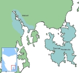
Tasman Peninsula
Encyclopedia
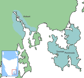
Hobart
Hobart is the state capital and most populous city of the Australian island state of Tasmania. Founded in 1804 as a penal colony,Hobart is Australia's second oldest capital city after Sydney. In 2009, the city had a greater area population of approximately 212,019. A resident of Hobart is known as...
, at the south east corner of Tasmania
Tasmania
Tasmania is an Australian island and state. It is south of the continent, separated by Bass Strait. The state includes the island of Tasmania—the 26th largest island in the world—and the surrounding islands. The state has a population of 507,626 , of whom almost half reside in the greater Hobart...
, Australia
Australia
Australia , officially the Commonwealth of Australia, is a country in the Southern Hemisphere comprising the mainland of the Australian continent, the island of Tasmania, and numerous smaller islands in the Indian and Pacific Oceans. It is the world's sixth-largest country by total area...
.
Description
Forestier Peninsula
The Forestier Peninsula is a peninsula of the Australian island state of Tasmania. Its coordinates are . It is connected to the mainland at East Bay Neck, near the town of Dunalley...
, to which it is connected by an isthmus called Eaglehawk Neck. This in turn is joined to the rest of Tasmania by an isthmus called East Bay Neck, near the town of Dunalley (about 60 kilometres or 37.3 mi by road from Hobart). Many smaller towns are also located on the Tasman Peninsula, the largest of which are Nubeena and Koonya. Smaller centres include Premaydena, Highcroft and Stormlea. The Conservation Park, located on the main highway at Taranna, is a popular local visitor attraction along with the Port Arthur
Port Arthur, Tasmania
Port Arthur is a small town and former convict settlement on the Tasman Peninsula, in Tasmania, Australia. Port Arthur is one of Australia's most significant heritage areas and the open air museum is officially Tasmania's top tourist attraction. It is located approximately 60 km south east of...
Historic Site and a number of beaches.
The local government area
Local Government Areas of Tasmania
- Local Government Areas of Tasmania, Australia :This article also includes lists of towns, suburbs and localities of Tasmania.-Brighton Council:*Hobart suburbs:**Bridgewater - Gagebrook - Old Beach*Brighton*Pontville*Tea Tree-City of Clarence:...
is the Tasman Council and the major route to Hobart is the Arthur Highway
Arthur Highway
The Arthur Highway is a Tasmanian highway which runs from Sorell in the near south to Port Arthur in the far south-east.It is notorious for crashes and was the focus of a media campaign to make it safer until late 2004, where it was superseded in danger by the equally notorious Lyell Highway....
. The population is around 2317 (estimate June 2006), which rises to around 8000 in summer months, mainly due to Port Arthur. The area of the peninsula and of the Local Government Area is 660 square kilometres (254.8 sq mi), which amounts to a population density of 3.5 PD/km2.
History
The area is named after DutchNetherlands
The Netherlands is a constituent country of the Kingdom of the Netherlands, located mainly in North-West Europe and with several islands in the Caribbean. Mainland Netherlands borders the North Sea to the north and west, Belgium to the south, and Germany to the east, and shares maritime borders...
explorer Abel Tasman
Abel Tasman
Abel Janszoon Tasman was a Dutch seafarer, explorer, and merchant, best known for his voyages of 1642 and 1644 in the service of the VOC . His was the first known European expedition to reach the islands of Van Diemen's Land and New Zealand and to sight the Fiji islands...
. The aboriginal inhabitants of this area preceding European arrival were the Pydairrerme
Tasmanian Aborigines
The Tasmanian Aborigines were the indigenous people of the island state of Tasmania, Australia. Before British colonisation in 1803, there were an estimated 3,000–15,000 Parlevar. A number of historians point to introduced disease as the major cause of the destruction of the full-blooded...
people. Their territory was what is now known as the Tasman and Forestier peninsulas. The Pydairrerme
Tasmanian Aborigines
The Tasmanian Aborigines were the indigenous people of the island state of Tasmania, Australia. Before British colonisation in 1803, there were an estimated 3,000–15,000 Parlevar. A number of historians point to introduced disease as the major cause of the destruction of the full-blooded...
people were a part of the larger Oyster Bay tribe, whose territory covered a large area of the east coast of Tasmania.
The first European settlement of the Peninsula was Port Arthur
Port Arthur, Tasmania
Port Arthur is a small town and former convict settlement on the Tasman Peninsula, in Tasmania, Australia. Port Arthur is one of Australia's most significant heritage areas and the open air museum is officially Tasmania's top tourist attraction. It is located approximately 60 km south east of...
in the early 1830s. It was selected as a penal settlement
Penal colony
A penal colony is a settlement used to exile prisoners and separate them from the general populace by placing them in a remote location, often an island or distant colonial territory...
because it was geographically isolated from the rest of the colony but more easily reachable by sea than the other place of secondary banishment, Macquarie Harbour
Macquarie Harbour
Macquarie Harbour is a large, shallow, but navigable by shallow draft vessels inlet on the West Coast of Tasmania, Australia.-History:James Kelly wrote in his narrative "First Discovery of Port Davey and Macquarie Harbour" how he sailed from Hobart in a small open five-oared whaleboat to discover...
on the west coast, which could then be closed down. It also had excellent supplies of timber for shipbuilding and general construction work, and a deep sheltered harbour where visiting British warships could be repaired. Its inaccessibility was enhanced by having Eaglehawk Neck lined with guards and guard dogs, to prevent the escape of any convicts. A small number did escape, including the notorious bushranger Martin Cash
Martin Cash
Martin Cash was a notorious convict bushranger known for escaping twice from Port Arthur, Van Diemen's Land...
.
The Saltwater River, Tasmania
Saltwater River, Tasmania
Saltwater River is a former penal colony on the Tasman Peninsula in Tasmania, Australia. It is located 23 kilometres from Port Arthur, and 106 kilometres from Hobart. At the 2006 census, Saltwater River had a population of 156.The Saltwater River area contained two penal settlements...
historic site (entry free), located near the north tip west of the peninsula, was originally the site of a convict-operated coal mine.
The penal settlement of Port Arthur is now a tourist attraction. As in most of the rest of the state, tourism
Tourism
Tourism is travel for recreational, leisure or business purposes. The World Tourism Organization defines tourists as people "traveling to and staying in places outside their usual environment for not more than one consecutive year for leisure, business and other purposes".Tourism has become a...
is a major industry. Bushwalking is also popular in the often rugged terrain, particularly picturesque spots being Cape Raoul and Cape Pillar at the extreme south west and south east ends of the Peninsula, separated by the entrance to Port Arthur.
Local industry
In the era between convict settlement and the rise of the modern tourist industry the area was mostly engaged in the timber industry and fishing. The terrain and soil types impeded large-scale agriculture although orcharding and general farming was and is conducted in suitable locations. The region remained highly isolated until the introduction of regular river steamer services between it and Hobart in the 1880s - these were further encouraged by the tourist industry to Port Arthur that began when overseas steamships began to call into Hobart, also during the 1880s. During the period 1900-1930s the main operator servicing the area was the Huon, Channel & Peninsula Steamship Company, owners of several vessels including the extant M.V. CartelaCartela
The MV Cartela is an excursion vessel operating on the Derwent River in Hobart, Tasmania, Australia. She is now Australia's oldest continuously licensed passenger vessel, although there are several older vessels still in service that have been restored after lengthy periods in dereliction.The...
.
Plants
The rare Cape Pillar SheoakAllocasuarina crassa
Allocasuarina crassa, commonly known as the Cape Pillar Sheoak, is a species of sheoak native to Australia.-Description:Allocasuarina crassa may vary in form from a prostrate shrub to a tree growing up to 14 m high. Its articles are 10-26 mm long and 1.2-4 mm in diameter, with...
is a shrub or small tree found only in the Tasman National Park where it is restricted to the Cape Pillar area of the Tasman Peninsula and to Tasman Island.
Birds
The peninsula forms part of the South-east Tasmania Important Bird AreaSouth-east Tasmania Important Bird Area
The South-east Tasmania Important Bird Area encompasses much of the land retaining forest and woodland habitats, suitable for breeding Swift Parrots and Forty-spotted Pardalotes, from Orford to Recherche Bay in south-eastern Tasmania, Australia.-Description:...
, identified as such by BirdLife International
BirdLife International
BirdLife International is a global Partnership of conservation organisations that strives to conserve birds, their habitats and global biodiversity, working with people towards sustainability in the use of natural resources...
because of its importance in the conservation of a range of woodland birds, especially the endangered Swift Parrot
Swift Parrot
The Swift Parrot breeds in Tasmania and migrates north to south eastern Australia from Griffith-Warialda in New South Wales and west to Adelaide in the winter. It is related to the rosellas, with the feeding habits of a lorikeet...
and Forty-spotted Pardalote
Forty-spotted Pardalote
The Forty-spotted Pardalote is one of Australia's rarest birds and by far the rarest pardalote, being confined to the south-east corner of Tasmania.-Description:...
.
Tasmanian Devil
While the region is best known for its convict history it is now the key area in the battle to save the Tasmanian DevilTasmanian Devil
The Tasmanian devil is a carnivorous marsupial of the family Dasyuridae, now found in the wild only on the Australian island state of Tasmania. The size of a small dog, it became the largest carnivorous marsupial in the world following the extinction of the thylacine in 1936...
from extinction from a new type of contagious cancer called Devil facial tumour disease
Devil facial tumour disease
Devil facial tumour disease is an aggressive non-viral transmissible parasitic cancer—which likely originated in Schwann cells—that affects Tasmanian devils. The first "official case" was described in 1996, in Australia...
(DFTD). The isolation from the Tasmanian mainland, where DFTD is running unchecked and has killed more than half of all devils, is ideal for maintaining a healthy wild Tasmanian Devil population in a project that involves the local Tasmanian Devil Conservation Park at Taranna and government and university scientists.
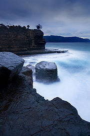
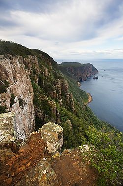
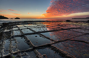
Coastline
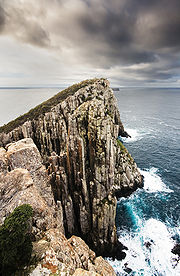
Tasman National Park
Tasman National Park is located in eastern Tasmania, Australia, 56 kilometres east of Hobart.-History:The park was proclaimed under the Regional Forest Agreement on 30 April 1999. The Tasman Island Lighthouse is located on Tasman Island, which is part of the park...
. At Eaglehawk Neck
Eaglehawk Neck, Tasmania
Eaglehawk Neck is a narrow isthmus connecting the Tasman Peninsula to mainland Tasmania. At the 2006 census, Eaglehawk Neck had a population of 269....
are many strange rock formations, including The Devils Kitchen, Tasman's Arch, Blow Hole and the Tessellated Pavement
Tessellated pavement
A tessellated pavement is a rare erosional feature formed in flat sedimentary rock formations lying on some ocean shores. The pavement bears this name because the rock has fractured into polygonal blocks that resemble tiles, or tessellations...
. Further south are the highest sea cliffs in the southern hemisphere, rising 300 m (984.3 ft) above the Tasman Sea
Tasman Sea
The Tasman Sea is the large body of water between Australia and New Zealand, approximately across. It extends 2,800 km from north to south. It is a south-western segment of the South Pacific Ocean. The sea was named after the Dutch explorer Abel Janszoon Tasman, the first recorded European...
at Cape Hauy. The peninsula is claimed to have some of Australia's best surf spots at Cape Raoul, Roaring Beach & Shipstern Bluff
Shipstern Bluff
Shipsterns Bluff is a surfing location on the south eastern coast of Tasmania on the Tasman Peninsula Australia. it was earlier known as Devils Point-Location:Shipsterns Bluff is located in between Cape Raoul & Tunnel Bay, Tasmania...
.
Further reading
- Storey, Shirley and Peter.(1990) Tasman tracks- 25 walks on the Tasman and Forestier Peninsulas Koonya Press.ISBN 0646018701