
.gif)
Swan River (Western Australia)
Encyclopedia
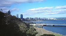
Perth, Western Australia
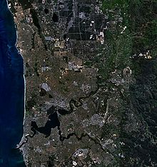
Perth is the capital and largest city of the Australian state of Western Australia and the fourth most populous city in Australia. The Perth metropolitan area has an estimated population of almost 1,700,000....
, in the south west
Southwest Australia
Southwest Australia is a biodiversity hotspot that includes the Mediterranean forests, woodlands, and scrub ecoregions of Western Australia. The region has a wet-winter, dry-summer Mediterranean climate, one of five such regions in the world...
of Western Australia
Western Australia
Western Australia is a state of Australia, occupying the entire western third of the Australian continent. It is bounded by the Indian Ocean to the north and west, the Great Australian Bight and Indian Ocean to the south, the Northern Territory to the north-east and South Australia to the south-east...
. Its lower reaches are relatively wide and deep, with few constrictions, while the upper reaches are usually quite narrow and shallow.
Swan Coastal Plain
The Swan Coastal Plain in Western Australia is the geographic feature which contains the Swan River as it travels west to the Indian Ocean. The coastal plain continues well beyond the boundaries of the Swan River and its tributaries, as a geological and biological zone, one of Western Australia's...
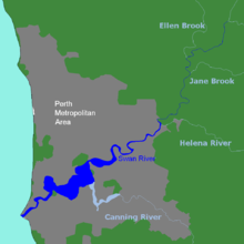
, which have a total area of about 121,000 km2. It has three major tributaries, the Avon River
Avon River (Western Australia)
The Avon River is a river in Western Australia. It is a tributary of the Swan River totalling 280 kilometres in length, with a catchment area of 125,000 square kilometres.-Catchment area:...
, Canning River and Helena River
Helena River
The Helena River is a tributary of the Swan River in Western Australia. The river rises in country east of Mount Dale and moves to the north west to Mundaring Weir, where it is dammed...
. The latter two have dams
DAMS
Driot-Arnoux Motorsport is a racing team from France, involved in many areas of motorsports. DAMS was founded in 1988 by Jean-Paul Driot and former Formula One driver René Arnoux. It is headquartered near Le Mans, only 2 km from the Bugatti Circuit.- History :The year after its foundation,...
(Canning Dam
Canning Dam
The Canning Dam and reservoir provide a major fresh water resource for the city of Perth, Western Australia. The dam is situated on the Darling Scarp and is an impoundment of the Canning River. It is noted for its innovative structural and hydraulic design that was considered to be at the forefront...
and Mundaring Weir
Mundaring Weir
Mundaring Weir is the name of a dam which are located from Perth, Western Australia in the Darling Scarp. It is situated in the Mundaring locality...
) which provide a sizeable part of the potable water requirements for Perth and the regions surrounding. The Avon River contributes the majority of the freshwater flow. The climate of the catchment is Mediterranean, with mild wet winters, hot dry summers, and the associated highly seasonal rainfall and flow regime.
The Avon rises near Yealering
Yealering, Western Australia
Yealering is a town in the Wheatbelt region of Western Australia, approximately 220km south-east of Perth between the towns of Wickepin and Corrigin. It is located beside a lake of the same name. While the town's population is small, it services a large agricultural district in the northern...
, 100 km southeast of Perth: it meanders north-northwest to Toodyay
Toodyay, Western Australia
Toodyay is a town located in the Wheatbelt region in the Avon Valley, 85 km north-east of Perth, Western Australia. Toodyay is connected to Perth via both rail and road.-History:...
about 90 km northeast of Perth, then turns southwest in Walyunga National Park
Walyunga National Park
Walyunga National Park is a national park in Western Australia , 35 km northeast of Perth along the Great Northern Highway.The park is situated just behind the Darling Scarp in the Darling Range spread over a steeply sided valley. The Swan-Avon River runs through the park and the Avon Descent...
- at the confluence of the Wooroloo Brook, it becomes the Swan River.
The Canning River rises not far from North Bannister
North Bannister, Western Australia
North Bannister is a small town located in the Wheatbelt region of Western Australia, south-southeast of the state capital, Perth along Albany Highway between Armadale and Williams....
, 100 km southeast of Perth and joins the Swan at Applecross
Applecross, Western Australia
Applecross is an affluent riverside suburb of Perth, Western Australia, bounded by Canning Highway and the Swan River. It is located within the City of Melville.Like the name Perth, the suburb of Applecross borrows its name from the region in Scotland...
, opening into Melville Water
Melville Water
Melville Water is a significant section of the Swan River in Perth, Western Australia. It is located west of and downstream of Perth Water from which it is separated by the Narrows Bridge.-Name:...
. The river then narrows into Blackwall Reach
Blackwall Reach (Western Australia)
Point Walter Blackwall Reach is a section of the Swan River in Western Australia.As a section of river it was named in the 1830s - and referred to that part of the river, not just one side of the river or other...
, a narrow and deep stretch leading the river through Fremantle Harbour
Fremantle Harbour
Fremantle Harbour is Western Australia's largest and busiest general cargo port and an important historical site. The inner harbour handles a large volume of sea containers, vehicle imports and livestock exports, cruise shipping and naval visits, and operates 24 hours a day.The harbour is also...
to the sea
Indian Ocean
The Indian Ocean is the third largest of the world's oceanic divisions, covering approximately 20% of the water on the Earth's surface. It is bounded on the north by the Indian Subcontinent and Arabian Peninsula ; on the west by eastern Africa; on the east by Indochina, the Sunda Islands, and...
.
The Noongar
Noongar
The Noongar are an indigenous Australian people who live in the south-west corner of Western Australia from Geraldton on the west coast to Esperance on the south coast...
believe that the Darling Scarp
Darling Scarp
The Darling Scarp, also referred to as the Darling Range or Darling Ranges, is a low escarpment running north-south to the east of the Swan Coastal Plain and Perth, Western Australia...
is said to represent the body of a Wagyl
Wagyl
The Wagyl is, according to Noongar culture, a snakelike dreamtime creature responsible for the creation of the Swan and Canning Rivers and other waterways and landforms around present day Perth and the south-west of Western AustraliaA superior being, the Rainbow Serpent created the universe and...
- a snakelike being from Dreamtime that meandered over the land creating rivers, waterways and lakes. It is thought that the Waugal created the Swan River.
The estuary is subject to a microtidal regime, with a maximum tidal amplitude of about one metre, although water levels are also subject to barometric pressure fluctuations.
Geology
Before the TertiaryTertiary
The Tertiary is a deprecated term for a geologic period 65 million to 2.6 million years ago. The Tertiary covered the time span between the superseded Secondary period and the Quaternary...
, when the sea level was much lower than at present, the Swan River curved around to the north of Rottnest Island
Rottnest Island
Rottnest Island is located off the coast of Western Australia, near Fremantle. It is called Wadjemup by the Noongar people, meaning "place across the water". The island is long, and at its widest point with a total land area of . It is classified as an A Class Reserve and is managed by the...
, and disgorged itself into the Indian Ocean slightly to the north and west of Rottnest. In doing so, it carved a gorge about the size of the Grand Canyon
Grand Canyon
The Grand Canyon is a steep-sided canyon carved by the Colorado River in the United States in the state of Arizona. It is largely contained within the Grand Canyon National Park, the 15th national park in the United States...
. Now known as Perth Canyon
Perth Canyon
Perth Canyon is a submarine canyon located on the edge of the continental shelf off the coast of Fremantle, Western Australia, approximately west of Rottnest Island. It was carved by the Swan River, probably before the Tertiary, when this part of the continental shelf was above sea level...
, this feature still exists as a submarine canyon
Submarine canyon
A submarine canyon is a steep-sided valley on the sea floor of the continental slope. Many submarine canyons are found as extensions to large rivers; however there are some that have no such association. Canyons cutting the continental slopes have been found at depths greater than 2 km below sea...
near the edge of the continental shelf
Continental shelf
The continental shelf is the extended perimeter of each continent and associated coastal plain. Much of the shelf was exposed during glacial periods, but is now submerged under relatively shallow seas and gulfs, and was similarly submerged during other interglacial periods. The continental margin,...
.
Geography
The Swan River drains the Swan Coastal Plain, a total catchment area of over100 000 km2 in area. The river is located in a Mediterranean climate, with hot dry summers and cool wet winters, although this balance appears to be changing due to climate change. The Swan is located on the edge of the Darling Scarp, flowing downhill across the coastal plain to its mouth at Fremantle
Fremantle
Freemantle is a suburb of Southampton in England.Fremantle or Freemantle may also refer to:- Places :* Fremantle, the port city to the capital Perth, Western Australia...
.
The Swan begins as the Avon River, rising near Yealering in the Darling Range
Darling Scarp
The Darling Scarp, also referred to as the Darling Range or Darling Ranges, is a low escarpment running north-south to the east of the Swan Coastal Plain and Perth, Western Australia...
, approximately 175 kilometres from its mouth at Fremantle. The Avon flows north, passing through the towns of Brookton
Brookton, Western Australia
Brookton is a town located in the Wheatbelt region of Western Australia, Australia, from the state capital, Perth via the Brookton Highway where it crosses the Great Southern Highway. The town is also located on the Great Southern railway line. It is located within, and is the seat of government...
, Beverley
Beverley, Western Australia
Beverley is a town located in the Wheatbelt region of Western Australia, south-east of the state capital, Perth, between York and Brookton on the Great Southern Highway...
, York
York, Western Australia
York is the oldest inland town in Western Australia, situated 97 km east of Perth in the Avon Valley near Northam, and is the seat of the Shire of York...
, Northam
Northam, Western Australia
Northam is a town in Western Australia, situated at the confluence of the Avon and Mortlock Rivers, about north-east of Perth in the Avon Valley. At the 2006 census, Northam had a population of 6,009. Northam is the largest town in the Avon region...
and Toodyay
Toodyay, Western Australia
Toodyay is a town located in the Wheatbelt region in the Avon Valley, 85 km north-east of Perth, Western Australia. Toodyay is connected to Perth via both rail and road.-History:...
. It is joined by tributaries including the Dale River
Dale River (Western Australia)
Dale River was named after Robert Dale, the first European exlorer to venture into the Darling Ranges in Western Australia in 1829.The Dale river is a tributary of the Avon river, it joins the Avon 10 km west of Beverley near the Avondale Agricultural Research Station.Tributaries of the Dale...
, the Mortlock River
Mortlock River
The Mortlock River is a river in the Wheatbelt of Western Australia.The headwaters of the river rise near Belmunging then flow in a northerly direction crossing the Goldfields Road and continuing in a north westerly direction to finally flow parallel to the Northam York Road and crossing Great...
and the Brockman River.
The Avon becomes the Swan as Wooroloo Brook enters the river near Walyunga National Park. More tributaries including Ellen Brook
Ellenbrook, Western Australia
Ellenbrook is a northeastern suburb of Perth, Western Australia, about 21 km from Perth's Central business district , located within the City of Swan. Ellenbrook, and its neighbouring suburbs of The Vines and Aveley, are unusual for Perth in being a significant distance from neighbouring suburbs...
, Jane Brook
Jane Brook, Western Australia
Jane Brook is a middle class suburb, situated approximately 25 kilometers east of the capital city Perth, Western Australia. It is a suburb within the City of Swan...
, Henley Brook, Wandoo Creek, Bennett Brook
Whiteman Park
Whiteman Park is a 4000-hectare/40-square-kilometre bushland area located 22 km north of Perth, Western Australia...
, Blackadder Creek, Limestone Creek, Susannah Brook, and the Helena River
Helena River
The Helena River is a tributary of the Swan River in Western Australia. The river rises in country east of Mount Dale and moves to the north west to Mundaring Weir, where it is dammed...
enter the river between Wooroloo Brook and Guildford
Guildford, Western Australia
Guildford is a suburb of Perth, Western Australia, located 13 km northeast of the city. Its Local Government Area is the City of Swan.-History:Guildford was established in 1829 on the Swan River, being sited near a permanent fresh water supply...
; however, most of these have either dried up or become seasonally flowing due to human impacts such as land clearing and development.
Between Perth and Guildford the river goes through several loops. Originally, areas including the Maylands Peninsula, Ascot
Ascot, Western Australia
Ascot is a suburb of Perth, the capital city of Western Australia, covering a narrow strip of land along the southern bank of the Swan River approximately east of Perth's central business district...
and Burswood
Burswood, Western Australia
Burswood is an inner southeastern suburb of Perth, Western Australia, located immediately across the Swan River from Perth's central business district via both The Causeway and Graham Farmer Freeway...
, through Claise Brook and north of the city to Herdsman Lake
Herdsman Lake
Herdsman Lake is a groundwater lake located 6 km north-west of Perth, Western Australia, in the suburb of Herdsman....
were swampy wetlands. Most of the wetlands have since been reclaimed for land development. Heirisson Island, upon which The Causeway
The Causeway
The Causeway is the name of the traffic crossing of the Swan River in Western Australia at the eastern end of Perth Water. Made up of two bridges on either side of Heirisson Island, the crossing links the City of Perth and Victoria Park....
passes over, was once a collection of small islets known as the Hierrison Islands.
Perth Water
Perth Water
Perth Water is the section of the Swan River between the Causeway to the east, and Narrows Bridge to the west - a large wide but shallow section of river on the southern edge of the City of Perth, Western Australia, and the northern edge of the suburb South Perth. Retrieved 29 December 2006...
, between the city and South Perth, is separated from the main estuary by the Narrows, over which the Narrows Bridge was built in 1959. The river then opens up into the large expanse of the river known as Melville Water. The Canning River enters the river at Canning Bridge in Applecross from its source 50 km south-east of Armadale
Armadale, Western Australia
Armadale is a suburb within the City of Armadale, located on the south-eastern edge of Perth's metropolitan area. The major junction of the South Western and Albany Highways, which connect Perth with the South West and Great Southern regions of Western Australia respectively, is located within the...
. The river is at its widest here, measuring more than 4 km from north to south. Point Walter has a protruding spit that extends up to 800 m into the river, forcing river traffic to detour around it. The river narrows between Chidley Point and Blackwall Reach, curving around Point Roe and Preston Point before narrowing into the harbour. Stirling Bridge and the Fremantle Traffic Bridge cross the river north of the rivermouth. The Swan River empties into the Indian Ocean at Fremantle Harbour.
Notable features
- Fremantle HarbourFremantle HarbourFremantle Harbour is Western Australia's largest and busiest general cargo port and an important historical site. The inner harbour handles a large volume of sea containers, vehicle imports and livestock exports, cruise shipping and naval visits, and operates 24 hours a day.The harbour is also...
- Rous Head
- Arthur Head
- Point Direction
- Preston Point
- Rocky Bay
- Point Roe
- Chidley Point
- Blackwall ReachBlackwall Reach (Western Australia)Point Walter Blackwall Reach is a section of the Swan River in Western Australia.As a section of river it was named in the 1830s - and referred to that part of the river, not just one side of the river or other...
- Point Walter
- Mosman Bay
- Keanes Point
- Freshwater Bay
- Point Resolution
- Melville WaterMelville WaterMelville Water is a significant section of the Swan River in Perth, Western Australia. It is located west of and downstream of Perth Water from which it is separated by the Narrows Bridge.-Name:...
- Lucky BayLucky BayLucky Bay is a bay located at on the south coast of Western Australia.It received its name from Matthew Flinders, who discovered it in January 1802. Flinders had sailed into the hazardous Archipelago of the Recherche, and found his ship surrounded by islands and rocks with nightfall coming on:...
- Point Waylen
- Alfred CoveAlfred Cove, Western AustraliaAlfred Cove is a southern suburb of Perth, Western Australia. Its Local Government Area is the City of Melville.-History:It is named after the adjacent sheltered cove in the Swan River, which is in turn named after Alfred Waylen, a pioneer settler in the area who was granted Swan Location 74,...
- Point Dundas
- Waylen Bay
- Point HeathcotePoint HeathcotePoint Heathcote is a geographic feature located on the south east part of Melville Water on Swan River.It is located in Applecross a suburb of Perth, Western Australia-History:...
- Mill Point
- Point BelchesPoint BelchesPoint Belches is a small point on the south side of Swan River, Western Australia, about 250 metres east of The Narrows within the area known as Perth Water...
- Pelican PointPelican Point, Western AustraliaPelican Point is a northeastern suburb of Bunbury, Western Australia, adjoining Eaton and located 6 km from the centre of Bunbury. Its Local Government Area is the City of Bunbury.-History:...
- Matilda BayMatilda BayMatilda Bay is a natural bay in the Swan River in Western Australia, adjacent to the Perth suburb of Crawley. It extends from Pelican Point to Mounts Bay Road below Kings Park....
- The Narrows
- Perth WaterPerth WaterPerth Water is the section of the Swan River between the Causeway to the east, and Narrows Bridge to the west - a large wide but shallow section of river on the southern edge of the City of Perth, Western Australia, and the northern edge of the suburb South Perth. Retrieved 29 December 2006...
- Heirisson IslandHeirisson IslandHeirisson Island is an island in the Swan River in Western Australia at the eastern end of Perth Water . The city of Perth and the Town of Victoria Park are linked by The Causeway which is actually two bridges which span the two foreshores and the island...
- ClaisebrookClaisebrookClaisebrook is an area in the CBD of Perth, Western Australia, and may refer to:*The Claisebrook Train Station, Perth, or*The railway depot for maintaining Perth's electric trains....
- Maylands PeninsulaMaylands, Western AustraliaMaylands is a suburb located approximately northeast of Perth centred on the Midland railway line and located on the northern bank of the Swan River....
- Ron Courtney Island
- Swan Valley
Flora and fauna
- Over 130 species of fish
- PrawnsIndian prawnThe Indian prawn, Fenneropenaeus indicus , is one of the major commercial prawn species of the world. It is found in the Indo-West Pacific from eastern and south-eastern Africa, through India, Malaysia and Indonesia to southern China and northern Australia.-Common names:F...
- CrabsPortunus pelagicusPortunus pelagicus, also known as the flower crab, blue crab, blue swimmer crab, blue manna crab or sand crab, is a large crab found in the intertidal estuaries of the Indian and Pacific Oceans and the Middle-Eastern coast of the Mediterranean Sea. The name "flower crab" is used in east Asian...
- MusselsMytilidaeMytilidae is a family of small to large saltwater mussels, marine bivalve mollusks in the order Mytiloida. It is the only family in the order...
- AlgaeAlgaeAlgae are a large and diverse group of simple, typically autotrophic organisms, ranging from unicellular to multicellular forms, such as the giant kelps that grow to 65 meters in length. They are photosynthetic like plants, and "simple" because their tissues are not organized into the many...
- PlanktonPlanktonPlankton are any drifting organisms that inhabit the pelagic zone of oceans, seas, or bodies of fresh water. That is, plankton are defined by their ecological niche rather than phylogenetic or taxonomic classification...
- DolphinsIndo-Pacific Bottlenose DolphinThe Indo-Pacific bottlenose dolphin is a species of bottlenose dolphin. The Indo-Pacific bottlenose dolphin grows to long, and weigh up to . It lives in the waters around India, northern Australia, South China, the Red Sea, and the eastern coast of Africa. Its back is dark grey and its belly...
- Sharks
- Birds, including:
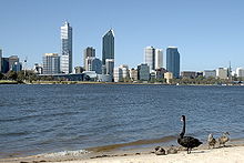
- the eponymous Black SwanBlack SwanThe Black Swan is a large waterbird, a species of swan, which breeds mainly in the southeast and southwest regions of Australia. The species was hunted to extinction in New Zealand, but later reintroduced. Within Australia they are nomadic, with erratic migration patterns dependent upon climatic...
- Sea gullsSilver GullThe Silver Gull also known simply as "seagull" in Australia, is the most common gull seen in Australia. It has been found throughout the continent, but particularly coastal areas. The South African Hartlaub's Gull and the New Zealand Red-billed Gull The Silver Gull (Chroicocephalus...
- Cormorants (locally referred to as 'shags')
- Twenty-Eight parrotsAustralian RingneckThe Australian Ringneck is a parrot native to Australia. Except for extreme tropical and highland areas, the species has adapted to all conditions...
- Rainbow LorikeetRainbow LorikeetThe Rainbow Lorikeet, is a species of Australasian parrot found in Australia, eastern Indonesia , Papua New Guinea, New Caledonia, Solomon Islands and Vanuatu. In Australia, it is common along the eastern seaboard, from Queensland to South Australia and northwest Tasmania...
- KingfisherKingfisherKingfishers are a group of small to medium sized brightly coloured birds in the order Coraciiformes. They have a cosmopolitan distribution, with most species being found in the Old World and Australia...
- CockatooRed-tailed Black CockatooThe Red-tailed Black Cockatoo , also known as Banksian- or Banks' Black Cockatoo, is a large cockatoo native to Australia. This species was known as Calyptorhynchus magnificus for many decades until the current scientific name was officially conserved in 1994. It is more common in the drier parts...
- PelicanAustralian PelicanThe Australian Pelican is a large water bird, widespread on the inland and coastal waters of Australia and New Guinea, also in Fiji, parts of Indonesia and as a vagrant to New Zealand.-Taxonomy:...
- MagpieAustralian MagpieThe Australian Magpie is a medium-sized black and white passerine bird native to Australia and southern New Guinea. A member of the Artamidae, it is closely related to the butcherbirds...
- HeronHeronThe herons are long-legged freshwater and coastal birds in the family Ardeidae. There are 64 recognised species in this family. Some are called "egrets" or "bitterns" instead of "heron"....
- DuckDuckDuck is the common name for a large number of species in the Anatidae family of birds, which also includes swans and geese. The ducks are divided among several subfamilies in the Anatidae family; they do not represent a monophyletic group but a form taxon, since swans and geese are not considered...
- the eponymous Black Swan
History
Willem de Vlamingh
Willem Hesselsz de Vlamingh was a Dutch sea-captain who explored the central west coast of Australia in the late 17th century.- Vlamingh and the VOC :...
in 1697 , after the famous black swan
Black Swan
The Black Swan is a large waterbird, a species of swan, which breeds mainly in the southeast and southwest regions of Australia. The species was hunted to extinction in New Zealand, but later reintroduced. Within Australia they are nomadic, with erratic migration patterns dependent upon climatic...
s of the area. Vlamingh sailed with a small party up the river to around Heirisson Island
Heirisson Island
Heirisson Island is an island in the Swan River in Western Australia at the eastern end of Perth Water . The city of Perth and the Town of Victoria Park are linked by The Causeway which is actually two bridges which span the two foreshores and the island...
. A French expedition under Nicholas Baudin also sailed up the river in 1801.
Governor Stirling's intention was that the name 'Swan River' refer only to the watercourse upstream of the Heirisson Islands. All of the rest, including Perth Water, he considered estuarine and which he referred to as 'Melville Water'. The Government notice dated 27 July 1829 stated ... the first stone will be laid of a new town to be called 'Perth', near the entrance to the estuary of the Swan River.
Almost immediately after the Town of Perth was established, a systematic effort was underway to reshape the river. This was done for many reasons:
- to alleviate flooding in winter periods;
- improve access for boats by having deeper channels and jetties;
- removal of marshy land which created a mosquito menace;
- enlargement of dry land for agriculture and building.
Perth streets were often sandy bogs which caused Governor James Stirling
James Stirling (Australian governor)
Admiral Sir James Stirling RN was a British naval officer and colonial administrator. His enthusiasm and persistence persuaded the British Government to establish the Swan River Colony and he became the first Governor and Commander-in-Chief of Western Australia...
in 1837 to report to the Secretary of State for Colonies:
At the present time it can scarcely be said that any roads exist, although certain lines of communication have been improved by clearing them of timber and by bridging streams and by establishing ferries in the broader parts of the Swan River ...
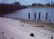
Parts of the river required dredging with the material dumped onto the mud flats to raise the adjoining land. An exceptionally wet winter in 1862 saw major flooding throughout the area - the effect of which was exacerbated by the extent of the reclaimed lands.
- Claisebrook - named Clause Brook on early maps, after Frederick ClauseFrederick ClauseDr. Frederick Rushbrook Clause was a naval surgeon who became an early explorer in Western Australia. He painted the only picture of the Swan River published prior to the establishment of the Swan River Colony....
. This was a fresh water creek which emptied the network of natural lakes north of the city. Before an effective sewerage system was built, it became an open sewer which dumped waste directly into the river for many years during the 1800s and early 1900s. The area surrounding has been mainly industrial for most of the period of European settlement and it has a long history of neglect. Since the late 1980s, the East Perth redevelopment has dramatically tidied up the area and works include a landscaped inlet off the river large enough for boats. The area is now largely residential and the brook exists in name only with the lakes having been either removed or managed by man-made drainage systems. - Point Fraser - early maps showed this as a major promontory on the northern side of the river west of the Causeway. It disappeared between 1921 and 1935 when land fill was added on both sides and effectively straightening the irregular foreshore and forming the rectangular 'The Esplanade'.
- The Esplanade - the northern riverbank originally ran close to the base of the escarpment generally a single block width south of St Georges Terrace. Houses built on the southern side of St Georges Terrace included market gardens which ran to the waters edge.
- Heirisson Islands - a series of mudflats that were slightly more upstream from today's single man-made island which has deep channels on each side.
- Burswood - early in the settlement the Perth flats restricted the passage of all but flat bottom boats travelling between Perth and Guildford. It was decided that a canal be built to bypass these creating Burswood Island. In 1831 it took seven men 107 days to do the work. Once completed, it measured about 280 metres in length by an average top width of nearly 9m which tapered to 4m at the bottom; the depth varied between nearly one metre and six metres. Further improvements were made in 1834. The area on the south side of the river upstream from the causeway was filled throughout the 1900s, reclaiming an area five-times the area of the Mitchell Interchange/Narrows Bridge works.
- Point Belches - later known as Mill Point, South Perth. Originally existed as a sandy promontory surrounding a deep semi-circular bay. This was later named Millers Pool and was eventually filled in and widened to become the present-day South Perth peninsula to which the Narrows Bridge and Kwinana Freeway adjoin.
- Point Lewis (also known as 'One-Tree Point' after a solitary tree that stood on the site for many years) - the northern side of the Narrows Bridge site, and now beneath the interchange.
- Mounts Bay - a modest reclamation was done between 1921 and 1935. In the 1950s works involving the Narrows Bridge started and in 1957 the bay was dramatically reduced in size with works related to the Mitchell Interchange and the northern approaches to the Narrows. An elderly Bessie RischbiethBessie RischbiethBessie Mabel Rischbieth, née Earle OBE was an influential and early Australian feminist and social activist. A leading or founding member of many social reform groups, such as the Women's Service Guilds, the Australian Federation of Women Voters and their periodical Dawn, she sought to establish...
famously protested against the project by standing in the shallows in front of the bulldozers for a whole day in 1957. She succeeded in halting progress - for that one day. - Bazaar Terrace/Bazaar Street - in the early days of the settlement this waterfront road between William Street and Mill Street was an important commercial focus with port facilities including several jetties adjoining. It is now approximately where Mounts Bay Road is today and set well back from the foreshore. It had a prominent limestone wall and promenade built using material quarried from Mount Eliza.
- River mouth at Fremantle - the harbour was built in the 1890s and the removal of the limestone reef blocking the river was removed after 70 years of demands. The dredging of the area to build the Harbour effectively changed the river dynamics from a winter flushing flow to a tidal flushing estuary. It was also at this time that the Helena River was dammed as part of C. Y. O'ConnorC. Y. O'ConnorCharles Yelverton O'Connor CMG was an Irish engineer who is best-known for his work in Australia, especially the Goldfields Water Supply Scheme.-Early life:...
's ambitious and successful plan to provide water to the KalgoorlieKalgoorlie, Western AustraliaKalgoorlie, known as Kalgoorlie-Boulder, is a town in the Goldfields-Esperance region of Western Australia, and is located east-northeast of state capital Perth at the end of the Great Eastern Highway...
Goldfields.
The river has been used for the disposal all kinds of waste. Even well into the 1970s various local councils had rubbish tips on the mud flats along the edge of the river. Heavy industry also contributed its share of waste into the river from wool scouring plants in Fremantle to fertilizer and foundries sited in the Bayswater - Bassendean area. Remedial sites works are still ongoing in these areas to remove the toxins left to leach into the river.
During the summer months there are problems with algal bloom
Algal bloom
An algal bloom is a rapid increase or accumulation in the population of algae in an aquatic system. Algal blooms may occur in freshwater as well as marine environments. Typically, only one or a small number of phytoplankton species are involved, and some blooms may be recognized by discoloration...
s killing fish and caused by nutrient run-off from farming activities as well as the use of fertilisers in the catchment areas. The occasional accidental spillage of sewage and chemicals has also caused sections of the river to be closed to human access. The river has survived all this and is in relatively good condition considering on-going threats to its ecology.
The Perth Water
Perth Water
Perth Water is the section of the Swan River between the Causeway to the east, and Narrows Bridge to the west - a large wide but shallow section of river on the southern edge of the City of Perth, Western Australia, and the northern edge of the suburb South Perth. Retrieved 29 December 2006...
location on the river adjacent to the City of Perth is a popular place for viewing the annual Australia Day
Australia Day
Australia Day is the official national day of Australia...
fireworks
Lotterywest Skyworks
The City of Perth Skyworks is a fireworks show that is held over the section of the Swan River in Perth, Western Australia known as Perth Water. It is held every Australia Day on the 26th of January....
, with over 400,000 people crowding the foreshore, Kings Park
Kings Park, Western Australia
Kings Park is a park located on the western edge of Perth, Western Australia central business district. The park is a mixture of grassed parkland, botanical gardens and natural bushland on Mount Eliza with two thirds of the grounds conserved as native bushland. With panoramic views of the Swan...
and boats on the river.
Flood events
Data collection of flood events in the estuary have been recorded since European arrival in 1829. In July 1830, barely a year after the establishment of the colony, the river rose 6 metres above its normal level. New settlers were still arriving in steady numbers and few permanent buildings had been constructed, with most living in tents and other temporary accommodation. These included caves along the river's edge and many found their belongings washed away and livestock drowned. Other abnormal floods events occurred in the winters of 1847 and 1860. Later events have since been assessed for probability of recurrence:| Year | 1862 | 1872 | 1910 | 1917 | 1926 | 1930 | 1945 | 1946 | 1955 | 1958 | 1963 | 1964 | 1983 |
| ARI* | 60 | 100 | 20 | 20 | 30 | 15 | 20 | 10 | 20 | 20 | 15 | 10 | 10 |
The largest recorded flood event was in July 1872 which had a calculated ARI of 100. This approximately equates to a 100-year flood
100-year flood
A one-hundred-year flood is calculated to be the level of flood water expected to be equaled or exceeded every 100 years on average. The 100-year flood is more accurately referred to as the 1% annual exceedance probability flood, since it is a flood that has a 1% chance of being equaled or exceeded...
event. At the Helena River, the 1872 flood level was two feet 3 inches higher that the 1862 event (ARI=60). An account in the The Perth Gazette and Western Australian Journal on 26 July 1872 reported
In and about Perth, the water owing to the force of the incoming seas at the mouth of the river presented a scene of a great lake, all the jetties were submerged, the high roads to Fremantle covered, and passage traffic rendered impossible quantities of sandalwood lying along the banks of river were washed away, and the inhabitants of the suburban villas on the slopes of Mount Eliza obliged to scramble up the hill sides to get into Perth.
The flood of 22 July 1926 (ARI=30) resulted in the washing away of the Upper Swan Bridge and the Fremantle Railway Bridge.
Governance
The Swan River Trust is a state government body, within the ambit of the Department of Environment and Conservation (Western Australia) - that was constituted in 1989 after legislation passed the previous year, that reports to the Minister for the Environment. It brings together eight representatives from the community, State and local government authorities with an interest in the Swan and Canning rivers to form a single body responsible for planning, protecting and managing Perth's river system.The Trust meets twice a month to provide advice to the Minister for the Environment, the Western Australian Planning Commission
Western Australian Planning Commission
The Western Australian Planning Commission is a statutory authority of the Government of Western Australia that exists to coordinate planning for future land use and transport needs. It describes itself as Western Australia's "peak representative body of land use planning and development"...
and river border related local government bodies to guide development of the Swan and Canning rivers.
Transport
In the earliest days of the Swan River Settlement, the river was used as the main transport route between Perth and Fremantle. This continued until the establishment of the Government rail system between Fremantle and Guildford via Perth.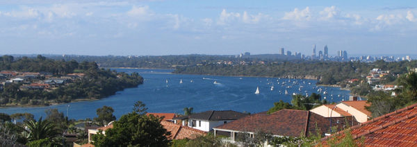
Bridges
Road
A road is a thoroughfare, route, or way on land between two places, which typically has been paved or otherwise improved to allow travel by some conveyance, including a horse, cart, or motor vehicle. Roads consist of one, or sometimes two, roadways each with one or more lanes and also any...
and railway bridge
Bridge
A bridge is a structure built to span physical obstacles such as a body of water, valley, or road, for the purpose of providing passage over the obstacle...
s crossing the Swan River. These are (from Fremantle, heading upstream
Source (river or stream)
The source or headwaters of a river or stream is the place from which the water in the river or stream originates.-Definition:There is no universally agreed upon definition for determining a stream's source...
):
- Fremantle Railway Bridge, North Fremantle to FremantleFremantle (suburb)Fremantle is a suburb of Perth, Western Australia, and contains the central business district and port of Fremantle.-Geography:Fremantle is bounded by the Swan River to the north and north-west, the Indian Ocean to the west, South Street to the south, and the suburbs of East Fremantle and White Gum...
(Fremantle railway line) - Fremantle Traffic Bridge, North Fremantle to Fremantle
- Stirling Bridge (Stirling HighwayStirling HighwayStirling Highway is, for most of its length, a four-lane single carriageway and major arterial road between Perth, Western Australia and the port city of Fremantle in Western Australia on the northern side of the Swan River. The speed limit is 60 km/h...
), North Fremantle to East FremantleEast Fremantle, Western AustraliaThe Town of East Fremantle is a Local Government Area in the southern suburbs of the Western Australian capital city of Perth, located immediately northeast of the port city of Fremantle and about southwest of Perth's central business district... - Narrows Bridge, South PerthSouth Perth, Western AustraliaSouth Perth is a residential suburb 3 kilometres south of the central business district of Perth, the capital of Western Australia, which adjoins the southern shore of Perth Water on the Swan River...
to Perth (Kwinana FreewayKwinana FreewayThe Kwinana Freeway is a major arterial road in Perth, Western Australia, linking Perth with the southern suburbs and then further on towards Mandurah, a distance of . It has a speed limit of , except in central Perth and south of Lakes Road . Like all Western Australian freeways, the minimum...
and Mandurah railway line; 2001) – northbound - Narrows Bridge, Perth to South Perth (Mandurah railway line)
- Narrows Bridge, Perth to South Perth (Kwinana Freeway; 1959) – southbound
- The CausewayThe CausewayThe Causeway is the name of the traffic crossing of the Swan River in Western Australia at the eastern end of Perth Water. Made up of two bridges on either side of Heirisson Island, the crossing links the City of Perth and Victoria Park....
(north), Perth to Heirisson IslandHeirisson IslandHeirisson Island is an island in the Swan River in Western Australia at the eastern end of Perth Water . The city of Perth and the Town of Victoria Park are linked by The Causeway which is actually two bridges which span the two foreshores and the island... - The Causeway (south), Heirisson Island to South Perth
- Goongoonup Bridge, East Perth to BurswoodBurswood, Western AustraliaBurswood is an inner southeastern suburb of Perth, Western Australia, located immediately across the Swan River from Perth's central business district via both The Causeway and Graham Farmer Freeway...
(Armadale railway line) - Windan Bridge, East Perth to Burswood, (Graham Farmer FreewayGraham Farmer FreewayThe Graham Farmer Freeway is a major part of the metropolitan road infrastructure in Perth, Western Australia. It is long and links Rivervale and East Perth with West Perth, bypassing Perth's central business district...
) - Garratt Road Bridge, BayswaterBayswater, Western AustraliaThe City of Bayswater is a Local Government Area in the inner northeastern suburbs of the Western Australian capital city of Perth, about northeast of Perth's central business district. The City covers an area of and has a estimated population of 61,865 as at June 2010.-History:The Bayswater Road...
to AscotAscot, Western AustraliaAscot is a suburb of Perth, the capital city of Western Australia, covering a narrow strip of land along the southern bank of the Swan River approximately east of Perth's central business district...
– northbound - Garratt Road Bridge, Ascot to Bayswater (Garratt Road and Grandstand Road) – southbound
- Redcliffe BridgeRedcliffe BridgeRedcliffe Bridge is a traffic bridge which carries Tonkin Highway across the Swan River in the Perth, Western Australia suburb of Redcliffe. Designed by Maunsell & Partners and built by Thiess,construction of the bridge started in 1986...
, Bayswater to Ascot (Tonkin HighwayTonkin HighwayTonkin Highway, at , is a limited access dual carriageway in Perth, Western Australia, connecting Reid Highway in the north with Thomas Road in the south. Mostly a 4 lane highway, some sections of the highway are to a 4 to 6 lane freeway standard; the remainder of the highway has been designed to...
) - Guildford Road Bridge, BassendeanBassendean, Western AustraliaBassendean is a northeastern suburb of Perth, Western Australia. Its Local Government Area is the Town of Bassendean.Bassendean is home to the Western Australian Rail Transport Museum. The display has a collection of Steam and Diesel Locomotives, most of these have been restored to operating...
to GuildfordGuildford, Western AustraliaGuildford is a suburb of Perth, Western Australia, located 13 km northeast of the city. Its Local Government Area is the City of Swan.-History:Guildford was established in 1829 on the Swan River, being sited near a permanent fresh water supply...
(Guildford Road and Bridge Street) - Guildford Railway Bridge, Bassendean to Guildford (Midland railway line)
- Barkers Bridge, Guildford to CavershamCaversham, Western AustraliaCaversham is a suburb of Perth, Western Australia, located in the City of Swan....
(Meadow Street and West Swan Road) - Whiteman Bridge, Caversham to Middle SwanMiddle Swan, Western AustraliaMiddle Swan is a rural suburb of Perth, Western Australia in the Swan Valley, and forms part of the City of Swan local government area. The suburb is bisected by the Swan River...
(Reid HighwayReid HighwayReid Highway is a major arterial highway in Perth, Western Australia. It is allocated Route 3, and runs between Marmion Avenue, North Beach, and West Swan Road, West Swan, a distance of...
and Roe HighwayRoe HighwayRoe Highway is a limited access dual carriageway in Western Australia. It links Great Northern Highway and Middle Swan Road with Kwinana Freeway. It is one of the key heavy vehicle routes in the Perth metropolitan area. Aside from intersections, the speed limit is 100 km/h for most of its length...
) - Maali Bridge, Henley BrookHenley Brook, Western AustraliaHenley Brook is an outer rural suburb of Perth, Western Australia, part of the Swan Valley wine region. The Ellen brook and Swan River meet in the northeastern corner of the suburb. This is also the farthest upstream Captain Stirling's 1827 exploration reached before deciding on the settlement...
to Herne HillHerne Hill, Western AustraliaHerne Hill is a suburb of Perth, Western Australia, located in the City of Swan local government area. The area holds several wineries that make the Swan Valley popular for its wine production.- Wineries :Carilley Estate, Highway Wines, Talijancich Wines,...
(pedestrian bridge; formerly called the Barrett Street Bridge) - Yagan Bridge, BelhusBelhus, Western AustraliaBelhus is a suburb of Perth, Western Australia. It is in the City of Swan local government area. It was named after the original English family estate owned by Edmund Barrett-Lennard, one of the pioneers of the Swan Valley table grape industry, in 1897....
to Upper SwanUpper Swan, Western AustraliaUpper Swan is a suburb of Perth, Western Australia, located in the City of Swan local government area.It contains Upper Swan Primary School....
(Great Northern HighwayGreat Northern HighwayThe Great Northern Highway is a generally north-south Western Australian highway which links the state's capital Perth with its most northern port, Wyndham. It is in length, with being National Highway...
; formerly called the Upper Swan Bridge) - Upper Swan railway bridge, Upper Swan (unnamed)
- Bells Rapids bridge, Upper Swan to BrigadoonBrigadoon, Western AustraliaBrigadoon is a suburb of Perth, Western Australia. It is in the City of Swan local government area.It sits on the edge of the Darling Scarp adjacent to the entrance to the Avon Valley through which the Avon River flows. The Bells Rapids is a popular viewing location for the annual Avon Descent...
(unnamed)
.jpg)
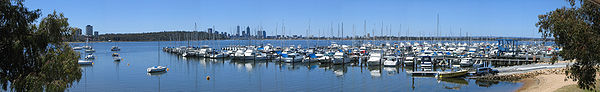
Yacht Clubs
There are currently fifteen yacht clubs along the Swan River, with most on Melville WaterMelville Water
Melville Water is a significant section of the Swan River in Perth, Western Australia. It is located west of and downstream of Perth Water from which it is separated by the Narrows Bridge.-Name:...
, Freshwater Bay
Freshwater Bay
Freshwater Bay can refer to:*The cove on the south coast of the Isle of Wight, England: see Freshwater, Isle of Wight*The bay in Newfoundland, Canada: see Freshwater Bay, Newfoundland*Freshwater Bay, Barbados*Freshwater Bay...
and Matilda Bay
Matilda Bay
Matilda Bay is a natural bay in the Swan River in Western Australia, adjacent to the Perth suburb of Crawley. It extends from Pelican Point to Mounts Bay Road below Kings Park....
. Royal Perth Yacht Club
Royal Perth Yacht Club
The Royal Perth Yacht Club is a yacht club in Perth, Western Australia. -Early history:The "Perth Yacht and Boat Club" in 1880 was able to build a jetty at the foot of William Street in Perth Water. Perth Yacht Club received the Royal Charter in 1890. The club shifted to Crawley in 1953 when the...
, on Pelican Point
Pelican Point (Swan River)
Pelican Point is a point and nature reserve on the Swan River in Perth, located at Matilda Bay near UWA.Pelican Point was formerly named Point Currie after Captain Currie who in 1829 received an allotment of land which became known as Crawley....
in Matilda Bay
Matilda Bay
Matilda Bay is a natural bay in the Swan River in Western Australia, adjacent to the Perth suburb of Crawley. It extends from Pelican Point to Mounts Bay Road below Kings Park....
, staged the unsuccessful 1987 America's Cup
1987 America's Cup
The 1987 America's Cup was the twenty-seventh challenge for the America's Cup and the first time for 132 years that it had not been defended by the New York Yacht Club....
defense, the first time in 132 years it had been held outside of the United States
United States
The United States of America is a federal constitutional republic comprising fifty states and a federal district...
. RPYC and the Royal Freshwater Bay Yacht Club
Royal Freshwater Bay Yacht Club
The Royal Freshwater Bay Yacht Club is a yacht club situated in Freshwater Bay on the Swan River in Peppermint Grove, a suburb of Perth, Western Australia....
are the only two clubs to be granted a royal charter
Royal Charter
A royal charter is a formal document issued by a monarch as letters patent, granting a right or power to an individual or a body corporate. They were, and are still, used to establish significant organizations such as cities or universities. Charters should be distinguished from warrants and...
. There are also many anchorages and marinas along the lower reaches near Fremantle
Fremantle, Western Australia
Fremantle is a city in Western Australia, located at the mouth of the Swan River. Fremantle Harbour serves as the port of Perth, the state capital. Fremantle was the first area settled by the Swan River colonists in 1829...
.
Cultural significance
There have been some north of the river or south of the river distinctions in the Perth metropolitan region over time, especially in the time up to the completion of the Causeway and Narrows bridges, due to the time and distances to cross the river. Some businesses do trade with a 'north of the river' phone number, and a separate 'south of the river' number.Further reading
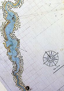
- Thompson, James (1911) Improvements to Swan River navigation 1830-1840 [cartographic material] Perth, W.A. : Western Australian Institution of Engineers, 1911. (Perth : Govt. Printer) Battye Library note: - Issued as Drawing no. 1 accompanying Inaugural address by Thompson 31 March 1910 as first president of the Western Australian Institution of Engineers, - Cadastral base map from Lands and Surveys Dept with additions by Thompson showing river engineering works from Burswood to Hierrison [i.e., Heirisson] islands and shorelines as they existed 1830-1840; includes Aboriginal place names along Swan River Estuary.
External links
- Swan River Trust
- Bridging to South Perth by Lloyd Margetts A copy of his speech given to the South Perth Historical Society.
- http://www.davidrumsey.com/maps864.html Historical map of the Swan River