
Weipa, Queensland
Encyclopedia
Weipa is the largest town on the Gulf of Carpentaria
coast of the Cape York Peninsula
in Queensland
, Australia
. At the 2006 census
, Weipa had a population of 2,830; the largest community on Cape York Peninsula
. It exists because of the enormous bauxite
deposits along the coast. The Port of Weipa is mainly involved in exports of bauxite and cattle.
, on his ship the Duyfken
, sighted the coast here in 1606. This was 164 years before Lieutenant James Cook
sailed up the east coast of Australia.
Very restrictive legislation was enacted by the state of Queensland in 1911, making the Protector the legal guardian of every Aborigine and half-caste child (until he/she was 21), and the right to confine (or expel) any such person within any reserve or Aboriginal institution, and the right to imprison any Aborigine or half-caste for 14 days if, in the Protector's judgement, they were guilty of neglect of duty, gross insubordination or wilful preaching of disobedience. It also gave powers to the police to confine Aborigines to reserves to "protect them from corruption". This latter power was given by Comalco in 1957 to justify the removal of Weipa Aborigines.
In 1932 the community had to relocate to its present site, at Jessica Point now called Napranum
, because of malaria
. It is about 12 km south of the present town of Weipa. At this time most of the people were Awngthim but soon different tribes and clans were brought from Old Mapoon
(when the people were forcibly removed and the settlement burnt down on 15 November 1963), and other communities.
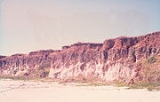
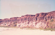
In 1955 a geologist, Henry Evans
(1912–1990), discovered that the red cliffs on the Aboriginal reserve, previously remarked on by the early Dutch explorers and Matthew Flinders
, were actually enormous deposits of bauxite
– the ore from which aluminium
is made – and to a lesser extent tungsten
.
The "Comalco Act of 1957" revoked the reserve status, giving the company 5,760 square km (2,270 sq mi) of Aboriginal reserve land on the west coast of the Peninsula and 5,135 square km (1,933 sq mi) on the east coast of Aboriginal-owned (though not reserve) land. Mining commenced in 1960. The mission became a government settlement in 1966 with continued attempts by Comalco
to relocate the whole community elsewhere. The company then built a new town for its workers on the other side of the bay.
 The present town was constructed mainly by Comalco
(now called Rio Tinto Alcan), a large aluminium company, which began making trial shipments of bauxite to Japan
in 1962. A railway was constructed to transport the ore from the mine at Andoom to the dump of the export facility at Lorim Point. The bauxite mine is the world's largest with planned expansions increasing the margin over other mines in 2010.
Gulf of Carpentaria
The Gulf of Carpentaria is a large, shallow sea enclosed on three sides by northern Australia and bounded on the north by the Arafura Sea...
coast of the Cape York Peninsula
Cape York Peninsula
Cape York Peninsula is a large remote peninsula located in Far North Queensland at the tip of the state of Queensland, Australia, the largest unspoilt wilderness in northern Australia and one of the last remaining wilderness areas on Earth...
in Queensland
Queensland
Queensland is a state of Australia, occupying the north-eastern section of the mainland continent. It is bordered by the Northern Territory, South Australia and New South Wales to the west, south-west and south respectively. To the east, Queensland is bordered by the Coral Sea and Pacific Ocean...
, Australia
Australia
Australia , officially the Commonwealth of Australia, is a country in the Southern Hemisphere comprising the mainland of the Australian continent, the island of Tasmania, and numerous smaller islands in the Indian and Pacific Oceans. It is the world's sixth-largest country by total area...
. At the 2006 census
Census in Australia
The Australian census is administered once every five years by the Australian Bureau of Statistics. The most recent census was conducted on 9 August 2011; the next will be conducted in 2016. Prior to the introduction of regular censuses in 1961, they had also been run in 1901, 1911, 1921, 1933,...
, Weipa had a population of 2,830; the largest community on Cape York Peninsula
Cape York Peninsula
Cape York Peninsula is a large remote peninsula located in Far North Queensland at the tip of the state of Queensland, Australia, the largest unspoilt wilderness in northern Australia and one of the last remaining wilderness areas on Earth...
. It exists because of the enormous bauxite
Bauxite
Bauxite is an aluminium ore and is the main source of aluminium. This form of rock consists mostly of the minerals gibbsite Al3, boehmite γ-AlO, and diaspore α-AlO, in a mixture with the two iron oxides goethite and hematite, the clay mineral kaolinite, and small amounts of anatase TiO2...
deposits along the coast. The Port of Weipa is mainly involved in exports of bauxite and cattle.
Geography
Weipa is just south of Duyfken Point, a location now agreed to be the first recorded point of European contact with the Australian continent. Dutch explorer Willem JanszoonWillem Janszoon
Willem Janszoon , Dutch navigator and colonial governor, is probably the first European known to have seen the coast of Australia. His name is sometimes abbreviated to Willem Jansz....
, on his ship the Duyfken
Duyfken
Duyfken was a small Dutch ship built in the Netherlands. She was a fast, lightly armed ship probably intended for shallow water, small valuable cargoes, bringing messages, sending provisions, or privateering...
, sighted the coast here in 1606. This was 164 years before Lieutenant James Cook
James Cook
Captain James Cook, FRS, RN was a British explorer, navigator and cartographer who ultimately rose to the rank of captain in the Royal Navy...
sailed up the east coast of Australia.
History
Weipa began as a Presbyterian Aboriginal mission outpost in 1898.Very restrictive legislation was enacted by the state of Queensland in 1911, making the Protector the legal guardian of every Aborigine and half-caste child (until he/she was 21), and the right to confine (or expel) any such person within any reserve or Aboriginal institution, and the right to imprison any Aborigine or half-caste for 14 days if, in the Protector's judgement, they were guilty of neglect of duty, gross insubordination or wilful preaching of disobedience. It also gave powers to the police to confine Aborigines to reserves to "protect them from corruption". This latter power was given by Comalco in 1957 to justify the removal of Weipa Aborigines.
In 1932 the community had to relocate to its present site, at Jessica Point now called Napranum
Napranum, Queensland
Napranum is a small community on the Cape York Peninsula in remote Far North Queensland. Formerly known as Weipa South, Napranum was established in 1898 by Moravian missionaries on behalf of the Presbyterian church. Napranum is now governed by a local Aboriginal council...
, because of malaria
Malaria
Malaria is a mosquito-borne infectious disease of humans and other animals caused by eukaryotic protists of the genus Plasmodium. The disease results from the multiplication of Plasmodium parasites within red blood cells, causing symptoms that typically include fever and headache, in severe cases...
. It is about 12 km south of the present town of Weipa. At this time most of the people were Awngthim but soon different tribes and clans were brought from Old Mapoon
Mapoon Aboriginal Mission Queensland
Mapoon Aboriginal Community is located at Port Musgrave, western Cape York in Queensland. A Presbyterian mission was established at Mapoon in 1891 with the aim of providing education and health services to the Aboriginal people. By 1907, under the Reformatories Act, it was operating as community...
(when the people were forcibly removed and the settlement burnt down on 15 November 1963), and other communities.
In 1955 a geologist, Henry Evans
Henry Evans
Henry Evans was an English cricketer who played for Derbyshire between 1878 and 1882.Evans was born in Stoneyford, Derbyshire the son of Thomas Evans, a farmer. He became a clerk with the Midland Railway....
(1912–1990), discovered that the red cliffs on the Aboriginal reserve, previously remarked on by the early Dutch explorers and Matthew Flinders
Matthew Flinders
Captain Matthew Flinders RN was one of the most successful navigators and cartographers of his age. In a career that spanned just over twenty years, he sailed with Captain William Bligh, circumnavigated Australia and encouraged the use of that name for the continent, which had previously been...
, were actually enormous deposits of bauxite
Bauxite
Bauxite is an aluminium ore and is the main source of aluminium. This form of rock consists mostly of the minerals gibbsite Al3, boehmite γ-AlO, and diaspore α-AlO, in a mixture with the two iron oxides goethite and hematite, the clay mineral kaolinite, and small amounts of anatase TiO2...
– the ore from which aluminium
Aluminium
Aluminium or aluminum is a silvery white member of the boron group of chemical elements. It has the symbol Al, and its atomic number is 13. It is not soluble in water under normal circumstances....
is made – and to a lesser extent tungsten
Tungsten
Tungsten , also known as wolfram , is a chemical element with the chemical symbol W and atomic number 74.A hard, rare metal under standard conditions when uncombined, tungsten is found naturally on Earth only in chemical compounds. It was identified as a new element in 1781, and first isolated as...
.
The "Comalco Act of 1957" revoked the reserve status, giving the company 5,760 square km (2,270 sq mi) of Aboriginal reserve land on the west coast of the Peninsula and 5,135 square km (1,933 sq mi) on the east coast of Aboriginal-owned (though not reserve) land. Mining commenced in 1960. The mission became a government settlement in 1966 with continued attempts by Comalco
Comalco
Rio Tinto Aluminium is now known as Rio Tinto Alcan after Rio's takeover of Alcan. It was the world's eighth largest aluminium company...
to relocate the whole community elsewhere. The company then built a new town for its workers on the other side of the bay.
Bauxite mining
Comalco
Rio Tinto Aluminium is now known as Rio Tinto Alcan after Rio's takeover of Alcan. It was the world's eighth largest aluminium company...
(now called Rio Tinto Alcan), a large aluminium company, which began making trial shipments of bauxite to Japan
Japan
Japan is an island nation in East Asia. Located in the Pacific Ocean, it lies to the east of the Sea of Japan, China, North Korea, South Korea and Russia, stretching from the Sea of Okhotsk in the north to the East China Sea and Taiwan in the south...
in 1962. A railway was constructed to transport the ore from the mine at Andoom to the dump of the export facility at Lorim Point. The bauxite mine is the world's largest with planned expansions increasing the margin over other mines in 2010.
Further reading
- Moon, Ron & Viv. 2003. Cape York: An Adventurer's Guide. 9th edition. Moon Adventure Publications, Pearcedale, Victoria. ISBN 0-9578766-4-5
- Moore, David R. 1979. Islanders and Aborigines at Cape York: An ethnographic reconstruction based on the 1848–1850 'Rattlesnake' Journals of O. W. Brierly and information he obtained from Barbara Thompson. Australian Institute of Aboriginal Studies. Canberra. ISBN 0-85575-076-6 (hbk); ISBN 0-85575-082-0 (pbk). USA edition ISBN 0-391-00946-X (hbk); ISBN 0-391-00948-6 (pbk).
- Roberts, Jan. 1981. Massacres to Mining: The Colonization of Aboriginal Australia. Dove Communications, Blackburn, Victoria. Rev. Australian ed. Previous ed: CIMRA and War on Want, 1978, London. ISBN 0-85924-171-8.
- Premier's Department (prepared by Connell Wagner). 1989. Cape York Peninsula Resource Analysis. Cairns. ISBN 0-7242-7009-6
- Roth, W.E. 1897. The Queensland Aborigines. 3 Vols. Reprint: Facsimile Edition, Hesperian Press, Victoria Park, W.A., 1984. ISBN 0-85905-054-8
- Ryan, Michelle and Burwell, Colin, eds. 2000. Wildlife of Tropical North Queensland: Cooktown to Mackay. Queensland Museum, Brisbane. ISBN 0-85905-045-9 (set of 3 vols).
- Scarth-Johnson, Vera. 2000. National Treasures: Flowering plants of Cooktown and Northern Australia. Vera Scarth-Johnson Gallery Association, Cooktown. ISBN 0-646-39726-5 (pbk); ISBN 0-646-39725-7 Limited Edition – Leather Bound.
- Sutton, Peter (ed). Languages of Cape York: Papers presented to a Symposium organised by the Australian Institute of Aboriginal Studies. Australian Institute of Aboriginal Studies, Canberra. (1976). ISBN 0-85575-046-4
- Wallace, Lennie. 2003. Cape York Peninsula: A History of Unlauded Heroes 1845–2003. Central Queensland University Press, Rockhampton. ISBN 1-876780-43-6
- Wynter, Jo and Hill, John. 1991. Cape York Peninsula: Pathways to Community Economic Development. The Final Report of The Community Economic Development Projects Cook Shire. Cook Shire Council.
External links
- "A Cape to Adventure" A description of a 4WD journey to Cape York by Roderick Eime
- Cooktown Shire Official web page
- Collection of photographs taken by Wolfgang Sievers in 1957 "Presbyterian Mission Station Weipa" held at National Library of Australia, Canberra
- University of Queensland: Queensland Places: Weipa