
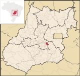
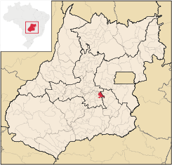
Leopoldo de Bulhões
Encyclopedia
| Leopoldo de Bulhões | |
|---|---|
| State | Goiás Goiás Goiás is a state of Brazil, located in the central part of the country. The name Goiás comes from the name of an indigenous community... |
| Area: | 495.0 km² |
| Population: | 8,916 (IBGE 2007) |
| Elevation: | 1,030 m above sea level |
| Postcode (CEP): | 75190-000 |
| Became a city: | 1948 |
| Distance to Goiânia Goiânia -Climate:The city has a tropical wet and dry climate with an average temperature of . There's a wet season, from October to April, and a dry one, from May to September. Annual rainfall is around 1,520 mm.... : |
56 km. |
| IBGE statistical microregion: | Goiânia Microregion Goiânia Microregion The Goiânia Microregion is a region in central Goiás state, Brazil. It includes 17 municipalities with a population of 2,032,305 in a total area of 6,848.00 km².... |
| Website: | none |
Municipality
A municipality is essentially an urban administrative division having corporate status and usually powers of self-government. It can also be used to mean the governing body of a municipality. A municipality is a general-purpose administrative subdivision, as opposed to a special-purpose district...
in central Goiás
Goiás
Goiás is a state of Brazil, located in the central part of the country. The name Goiás comes from the name of an indigenous community...
state, Brazil
Brazil
Brazil , officially the Federative Republic of Brazil , is the largest country in South America. It is the world's fifth largest country, both by geographical area and by population with over 192 million people...
. The total area was 495.0 km² in October 2002) and the population was 8,916 in 2007. The elevation is 1,030 meters above sea level, one of the highest in the state.
Political division
The territory is made up of the following settlements: Capelinha, Goiavista, São Caetano, Trevo do José Rosário, Vila Nova and Engenheiro Valente. Neighboring municipalities are: AnápolisAnápolis
Anápolis is the third largest city in the State of Goiás in Brazil. It lies in the center of a rich agricultural region and has become a leader in food processing and pharmaceutical plants.-Location and population:...
, Bonfinópolis
Bonfinópolis
Bonfinópolis is a small town and municipality in central Goiás state, Brazil. It is located a short distance east of Goiânia and is part of the Goiânia metropolitan area.The distance to Goiânia is 33 km...
, Caldazinha
Caldazinha
Caldazinha is a small town and municipality in central Goiás state, Brazil. The population was 3,157 in a total area of 312 km².Located 27 kilometers from the state capital, Goiânia, Caldazinha belongs to the Goiânia Microregion...
, Gameleira de Goiás
Gameleira de Goiás
Gameleira de Goiás is a municipality in central Goiás state, Brazil. The population in 2007 was 3,289 in a total area of 595 square kilometers.-Geographical Information:...
, Goianápolis
Goianápolis
Goianápolis is a small town and municipality in central Goiás state, Brazil. It had a population of 11,159 in a total area of 162.38 km²...
and Silvânia
Silvânia
Silvânia is a small city and municipality in southcentral Goiás state, Brazil.-Location and highway connections:Silvânia is located 77 kilometers from the state capital of Goiânia, 180 km...
.
Located in the Goiânia Microregion
Goiânia Microregion
The Goiânia Microregion is a region in central Goiás state, Brazil. It includes 17 municipalities with a population of 2,032,305 in a total area of 6,848.00 km²....
--it is 56 km from the state capital and is connected by BR-457 / GO-010 / Bonfinópolis
Bonfinópolis
Bonfinópolis is a small town and municipality in central Goiás state, Brazil. It is located a short distance east of Goiânia and is part of the Goiânia metropolitan area.The distance to Goiânia is 33 km...
/ GO-330.
Political information
In January 2005 the mayor was Raimundo Nonato Diniz Rodrigues, the vice mayor was João Teotônio Neto, and there were 9 councilmembers in the city government. There were 5,635 eligible voters in December 2007.Demographic information
The population density was 18.01 km² in 2007. In 1980 the population was 8,336 with urban and rural inhabitants evenly divided. In 1991 the population had decreased to 7,376. From 2000 to 2007 the population increased 1.99%. For the complete data see SeplanEducation and health
In the educational area there were 13 schools in activity, with 54 classrooms, 114 teachers, and a total of 2,158 students (2006). In the health area there was only one hospital, private, Hospital Vicente de Paula, with 29 beds. Besides the hospital there were 8 walk-in health clinics. The literacy rate was 85.7 in 2000 and the infant mortality rate was 31.42 in the same year.Economy
According to government statistics the municipality had 06 industrial units in 2007. There were 41 retail units. There was one dairy, Agropecuária e Laticínios Lebon Indústria e Comércio Ltda, in 2006. There was one bank institution, Banco Itaú S.A, in 2007.Livestock raising is important with a total of 40,250 cows in 2006, of which 8,800 were milk cows. The poultry industry is quite developed with 795,000 head being reported for 2006.
In agriculture the town produces sweet potatoes, tomatoes, soybeans, corn, bananas, manioc, beans, sugarcane, and sorghum. The largest crop in planted area was soybeans with 4,000 hectares planted in 2006.
History
In 1931, this settlement was raised to the category of district of Silvânia with the name of Leopoldo de Bulhões. This name was given in tribute to José Leopoldo de Bulhões Jardim, a state politician who was important at the time. The town saw enormous progress between 1928 and 1939, with the arrival of the tracks of the Estrada de Ferro Goyaz. For a certain time the station of Leopoldo de Bulhões was the last station on the railroad line, making it a strong motive for migration to the area. The railway line no longer operates.Human Development Index
Human Development Index
The Human Development Index is a composite statistic used to rank countries by level of "human development" and separate "very high human development", "high human development", "medium human development", and "low human development" countries...
: 0.715
- State ranking: 188 (out of 242 municipalities)
- National ranking: 2,730 (out of 5,507 municipalities)
For the complete list see Frigoletto.com
See also List of municipalities in Goiás