

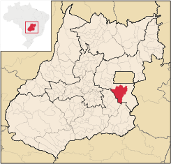
Luziânia
Encyclopedia
| Luziânia | |
|---|---|
| State | Goiás Goiás Goiás is a state of Brazil, located in the central part of the country. The name Goiás comes from the name of an indigenous community... |
| Coordinates: | 16°15′08"S 47°56′33"W |
| Area: | 3,961.0 km² |
| Population: | 196,046 (IBGE 2007) |
| Elevation: | 930 m above sea level |
| Postcode (CEP): | 72800-000 |
| IBGE statistical microregion: | Entorno de Brasília |
| Became a city: | 1833 |
| Distance to Goiânia Goiânia -Climate:The city has a tropical wet and dry climate with an average temperature of . There's a wet season, from October to April, and a dry one, from May to September. Annual rainfall is around 1,520 mm.... : |
186 km |
| Website: | Luziânia.com |
City
A city is a relatively large and permanent settlement. Although there is no agreement on how a city is distinguished from a town within general English language meanings, many cities have a particular administrative, legal, or historical status based on local law.For example, in the U.S...
and municipality
Municipality
A municipality is essentially an urban administrative division having corporate status and usually powers of self-government. It can also be used to mean the governing body of a municipality. A municipality is a general-purpose administrative subdivision, as opposed to a special-purpose district...
in the state of Goiás
Goiás
Goiás is a state of Brazil, located in the central part of the country. The name Goiás comes from the name of an indigenous community...
, Brazil
Brazil
Brazil , officially the Federative Republic of Brazil , is the largest country in South America. It is the world's fifth largest country, both by geographical area and by population with over 192 million people...
. This fast-growing city is a great producer of agricultural products including soybeans and beans.
Location
Luziânia is located 68 km. south of BrasíliaBrasília
Brasília is the capital city of Brazil. The name is commonly spelled Brasilia in English. The city and its District are located in the Central-West region of the country, along a plateau known as Planalto Central. It has a population of about 2,557,000 as of the 2008 IBGE estimate, making it the...
and is part of the greater Brasília metropolitan area, called Entorno de Brasília.
Although the city has existed as a settlement since colonial days, its rapid growth occurred in the eighties and nineties with the population explosion of the federal capital and the need for less expensive living areas outside the planned city.
The municipality is limited in the north by Valparaíso de Goiás
Valparaíso de Goiás
Valparaíso de Goiás is a city and municipality in east-central Goiás state, Brazil. It is a suburb of Brasília.-Location:Valparaíso is located on the plateau known as Planalto Central, southwest of Brasília and is part of the greater Brasília area known as the Entorno de Brasília...
and Novo Gama
Novo Gama
Novo Gama is a city and municipality in eastern Goiás state, Brazil. It is part of the greater Brasília metropolitan area. In 2007 the population was 83,599 inhabitants.-Location:...
; in the south by Orizona
Orizona
Orizona is a small town and municipality in Goiás state, Brazil.-Location:Orizona is 138 km from the state capital of Goiânia, 200 km from Brasília, 150 from Catalão and 260 from Uberlândia, which is located in the rich Triângulo Mineiro of Minas Gerais. It is part of the Pires do Rio...
and Ipameri
Ipameri
Ipameri is a small city and municipality in southeastern Goiás state, in Brazil. The population was 23,114 in a total area of 4,368.6 km² . It is a major producer of soybeans, corn, and livestock.-Location and connections:...
; in the west by Santo Antônio do Descoberto
Santo Antônio do Descoberto
Santo Antônio do Descoberto is a small city and municipality in central Goiás state, Brazil. It is a suburb of Brasília that was a sleepy country hamlet until the population exploded in the 1970s due to the construction of the national capital...
, Alexânia
Alexânia
Alexânia is a small town and municipality in central Goiás state, Brazil. Alexânia is known for its alleged extraterrestrial sightings in the late sixties and early seventies. The Areias River passes through the municipality.-Location:...
, and Silvânia
Silvânia
Silvânia is a small city and municipality in southcentral Goiás state, Brazil.-Location and highway connections:Silvânia is located 77 kilometers from the state capital of Goiânia, 180 km...
; and in the east by Cristalina
Cristalina
Cristalina is a small city located in the southeast of the state of Goiás, Brazil.-Location:Cristalina is located directly south of the federal capital, Brasília, and is connected to that city by BR-040...
.
A case of rapid growth
Luziânia is the classic example of a small town that grew extremely fast without time for the infrastructure to catch up with the population. Once the site of a major gold discovery in 1746 that attracted prospectors from far way, the city today has little of its colonial origins. The urban zone, made up of nuclei of population, extends for more than 20 km. along the BR 040 highway, which connects Belo Horizonte with Brasília. These nuclei of population are at the same time interconnected with those of neighboring municipalities forming a continuous urban zone of 40 km. as far as Brasília.Many of the inhabitants of these satellite towns were either arrivals from other states, mainly the Northeast, or dwellers of Brasília forced out by increasing high living costs. Most of them are poor and create serious problems for the government of Luziânia, forced to provide health care and education for a population that has tripled in the last twenty years. In addition, the distance from the state capital (255 km.) means that resources are not destined to a region that is considered to be more connected to Brasília than to Goiânia. Consequently, economic and social indicators for Luziânia are much lower than those for Brasília.
Demographic data
In 2007 population density was 49.49 inhab/km². The population has almost doubled since 1980, when it was 92,817. Today it is over 190,000 with fewer than 20,000 living in the rural area. (IBGE/Sepin)In 1996 the population had grown to 246,000, but then the city lost much of its territory and population due to the formation of new municipalities like Valparaíso de Goiás
Valparaíso de Goiás
Valparaíso de Goiás is a city and municipality in east-central Goiás state, Brazil. It is a suburb of Brasília.-Location:Valparaíso is located on the plateau known as Planalto Central, southwest of Brasília and is part of the greater Brasília area known as the Entorno de Brasília...
and Cidade Ocidental
Cidade Ocidental
Cidade Ocidental is a small city and municipality located in central Goiás state, Brazil. It is a suburb of Brasília.-Geography:It is bordered on the north by the Federal District, on the south by Luziânia, on the east by Cristalina and Luziânia, and on the west by Luziânia and Valparaíso de...
.
Since 1996 the population has continued to grow, showing an increase of 4.81% from 2000 to 2007. (IBGE/Sepin)
The economy
Until the eighties Luziânia was a sleepy little agricultural town a half hour's drive away from BrasíliaBrasília
Brasília is the capital city of Brazil. The name is commonly spelled Brasilia in English. The city and its District are located in the Central-West region of the country, along a plateau known as Planalto Central. It has a population of about 2,557,000 as of the 2008 IBGE estimate, making it the...
. Then agribusiness discovered the relatively flat lands that could produce high yields of soybeans with central pivot irrigation. Today the city is one of the most prosperous in the state and the second largest producer of beans and potatoes in the state, and the third largest producer of cotton and corn. In fruit cultivation it is the first producer in the state of guava and the fourth of tomatoes and passion fruit (maracujá). Planted area of the main crops in 2006 was: cotton, 1,334 hectares; rice, 1,000 hectares; beans, 24,000 hectares; corn, 15,000 hectares; and soybeans, 40,000 hectares.
The economy is also strong in cattle raising (187,000 head in 2006), both for meat and dairy, as well as semi-precious stones, gravel, bricks, and a well-known sweet made from quince. Due to the proximity to Brasília
Brasília
Brasília is the capital city of Brazil. The name is commonly spelled Brasilia in English. The city and its District are located in the Central-West region of the country, along a plateau known as Planalto Central. It has a population of about 2,557,000 as of the 2008 IBGE estimate, making it the...
there is extensive production of fruits and garden vegetables. The poultry industry is highly developed with 1,227,000 birds in 2006.
In a study made by the Secretaria do Planejamento e Desenvolvimento (Seplan) Luziânia was ranked in seventh place in the state in competitiveness..
Agricultural data 2006
- Farms: 1,767
- Total area: 216,990 ha.
- Area of permanent crops: 10,019 ha.
- Area of perennial crops: 39,146 ha.
- Area of natural pasture: 112,084 ha.
- Area of woodland and forests: 51,021 ha.
- Persons dependent on farming: 6,100
- Number of tractors: 440
- Cattle herd: 187,000
| Products in 2005 (km²) | |
|---|---|
| Beans | 140 |
| Coffee: | 3.2 |
| Corn | 110 |
| Cotton | 5 |
| Guava | 1.3 |
| Rice | 12 |
| Sorghum | 6 |
| Soybeans | 500 |
| Wheat | 12 |
The municipality is rich in gold, rock crystals and hardwoods like jatobá, aroeira, peroba, and angico are still found in the fast disappearing forests, now existing mainly on the river banks.
The Corumbá River
Corumbá River
The Corumbá River is the most important river in the Central Plateau region of Brazil. Its source is in the Montes de Pireneus, near Pirenópolis, state of Goiás, near the boundary with the Federal District and its length ifs 567 km. It receives the waters of the Descoberto and São Bartolomeu,...
passes west of the city and receives its untreated sewage, seriously polluting the river waters.
Health and education
In 2006 the city had two hospitals with 106 beds and 35 walk-in clinics. The infant mortality rate was 21.11 in 2000, well below the state and national average.The school system had 108 schools in 2007, with 51,799 students and 1,603 teachers. In July 2007 there were two institutions of higher learning: a private school—Faculdades Integradas do Planalto Central-FIPLAC; and a campus of the state university—Unidade Universitária da UEG. The literacy rate was 89.2% in 2000.
- MHDI: 0.756
- State ranking: 65 (out of 242 municipalities)
- National ranking: 1,706 (out of 5,507 municipalities)
(All data are from 2000.)
Notes