

Anadyrsky District
Encyclopedia
Anadyrsky District is an administrative and municipal district (raion
), one of the six in Chukotka Autonomous Okrug
, Russia
. It is located in the interior portion of the autonomous okrug and in terms of administrative divisions borders with Chaunsky District
in the northwest, Iultinsky District
in the north and northeast, the Anadyr Bay in the east, Koryak Okrug in the south, and Bilibinsky District
in the west. Its administrative center is the town of Anadyr
(which is not administratively a part of the district). District's population: 6,646 (2010 est.);
In terms of area, this is the largest administrative district in the autonomous okrug. The district is located in a mountainous region, the peaks of which provide the catchment areas for the Anadyr River
and its tributaries
. The district is home to a large number of indigenous peoples as well as Russians
and Ukrainians
. Human existence in what is now Anadyrsky District is known to have occurred for at least the last 5,000 years. Following the foundation of the first Russian-speaking settlements by Semyon Dezhnyov, the area became the key part of the region in terms of trade, exploration, and administration, which still continues today.
of the Anadyr River
. It covers much of the interior of Chukotka. The eastern border consists of coastline on the Bering Sea
.
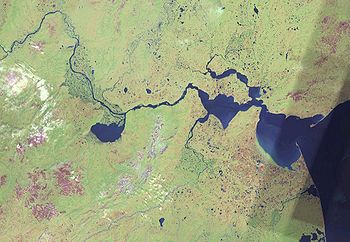
The vastness of the district means that natural conditions within it vary considerably, from the mountainous tundra found in the north, to impenetrable woodland in the south, to wind-lashed coast to the east. The district, particularly its eastern part, is dominated by the 800 kilometres (497.1 mi)-long Anadyr River, which forms an estuary
known as the Anadyrsky Liman, which empties into the Gulf of Anadyr
. All of the major inhabited localities on the territory of the district (Anadyr, Ugolnye Kopi
, and Shakhtyorsky
) are found on the banks of this estuary. The boundary between the estuary and the Gulf of Anadyr is marked by the Russkaya Koshka
, literally translated as Russian Cat, although "koshka" is a local term meaning "spit". The vast majority of all inhabited localities of any size are to be found either along the Anadyr or one of its tributaries.
The Anadyr Plateau and Pekulneysky mountain range are found in the north and northwest of the district, within which the upper reaches of the Anadyr River
drain.
More southerly tributaries of the Anadyr River, such as the Mayn River, have their source in the spurs of the Koryak Mountains
in the south of the district. The northeastern-most extent of the Taiga
is found in Anadyrsky District, in the west of the district, on Opalyonnaya Mountain, near the village of Markovo
.
A large part of the district is covered by the Anadyr Valley, consisting of two distinct sections: a plain extending from Anadyrsky Liman in the east approximately 500 kilometres (310.7 mi) to Markovo and a more elevated region within the Shchuchy Range. For a district dominated by a major river and its tributaries, it is unsurprising that the interior of the district is dominated by wetlands covering tens of thousands of square kilometers. These wetlands create innumerable small lakes, although there is only one large lake, Lake Krasnino, with the area of 458 square kilometres (176.8 sq mi), in the entire district. The Anadyr Valley opens out into a large estuary containing the Gulf of Onemen and the Gulf of Anadyr
. The district is also home to Lake Elgygytgyn, found in the center of an impact crater
created just under three and a half million years ago.
The easternmost part of the district is covered by the Uelkalskaya tundra, and the area of the Anadyr Estuary contains a number of shingle spits and intertidal silt flats.
 Approximately three-quarters of the population is of non-indigenous origin; mainly Russian and Ukrainian. These people either migrated to the Far East
, or are the descendants of those who did, enticed by the higher pay, large pensions, and more generous allowances permitted to those prepared to endure the cold and the isolation, or, more likely, were exiled here as a result of one of Stalin
's purges, or were exiled here having been released from the Gulag
.
Although only consisting of 27% of the total population of the district, this is formed of a considerable number of different indigenous peoples. The most represented indigenous people are the Chukchi
, who are present in all but the most westerly and northwesterly parts of the district. The Evens
are more populous in Bilibinsky District
but are also found in the west and northwest of Anadyrsky District. The Koryaks
, originally native across much of Siberia
, were pushed into Kamchatka by the Evens, but have now moved over the border into Chukotka as well and are now found in the southwest of the district. Also found are the Yukaghirs and Chuvans
, who occupy a small area of land in the far west of the district near the border with Bilibinsky District surrounding the village of Chuvanskoye
.
According to an environmental impact report produced by Bema Gold
for the Kupol gold project in 2005, the indigenous population of Anadyrsky Municipal District for 2003 was 3,033. Of these indigenous people, 60% were Chukchi, 25% Chuvan, 5% Lamut and 4% Even. These people were part of the population of 10 of the inhabited localities within the district. There were approximately the following numbers of indigenous people in 2003 in Anadyrsky Municipal District settlements (in decreasing order of representation):
Anadyrsky District shares many demographic similarities with Chaunsky District
to the north. As the population of Chaunsky District is centered mainly around Pevek, so, too, the majority of the population of Anadyrsky District is concentrated in Ugolnye Kopi. Anadyr, the administrative center of the autonomous okrug, while administratively separate from the district, also serves as a population hub of the area. The remainder of the population is scattered throughout a handful of smaller localities. As Chaunsky District is served by Pevek Airport
, the second largest in the autonomous okrug, so is Anadyrsky District served by Anadyr Ugolny Airport.
type of people has been revealed, surviving from reindeer
hunting.
Around 2000 BCE, the first genuine Chukotkan culture began to emerge on the territory of what is now Anadyrsky District. The people who had previously existed solely on the tundra
, gravitated towards new settlements on the riverbanks of the Kanchalan River, near the present site of the village (selo) of Kanchalan
, from where the culture gets its name. These people no longer relied on hunting for survival, but combined this with fishing. The fishing eventually developed into open sea hunting for whale
s and walrus
es, whilst those who still lived off the land began to tame the wild reindeer they hunted to form ever larger herds.
(fort) of Nizhnekolymsky, a settlement which still survives near Chersky
in the present-day Sakha Republic, in search of furs and silver. Having met with almost total destruction as they rounded Cape Chukotsky Nos, a cape that would later bear Dezhnyov's name, when all but Dezhnyov's own ship were lost, he eventually found his way into the Anadyrsky Liman, followed the river upstream, and founded a camp which was the first Russian-speaking settlement in the region. This camp was the basis for the creation of Anadyrsk
, an ostrog which would be come a key element in the Russification of the region.
With the discovery of Kamchatka at the end of the 17th century, Anadyrsk's importance grew still further as an administrative and economic hub for the whole area. The fort itself had expanded as well with the foundation of several villages including Markovo
.
Throughout the first half of the 18th century, relations with the local indigenous peoples were tense. Trade did take place, but the Chukchi were unwilling to submit to Russians and pay them protection money. By the mid-18th century, a viable sea route to Kamchatka had been discovered and Anadyrsk consequently lost its importance as a regional hub, with Catherine the Great ordering its demolition in 1766.
At the beginning of the 19th century, the Russian-American Company
was founded and established a united trading base for a number of enterprises. Although there were still skirmishes with the local population, this attempt proved more successful and the Russians were able to make use again of the area around the former fort of Anadyrsk. In 1888, Markovo was made the administrative center of the district. At the same time, a Russian-American Company employee named Pyotr Baranov established a small trading base on the site of present-day Anadyr.
Due to the distance between Anadyrsky District and Moscow, news of the October Revolution
took nearly a month to arrive and even when it did, Bolshevik
politics did not immediately seize control. When Bolshevik partisans finally seized control of Anadyr in December 1919, they were overthrown by the kulak
merchants soon after being established; perhaps not surprisingly since they were the only three Bolsheviks in the area.
It was not until 1923 that the Revkom had removed all opposition, but the revolution had created serious economic problems, with the private companies that previously managed all of the districts fishing and general trade no longer in existence. To deal with the situation, the Hudson's Bay Company
were contracted to manage the fishing in the district, but failed to fulfill their contract.
During World War II
, an airport was established in Markovo as part of the Uelkal
–Krasnoyarsk
route. This airport is still in existence and served by Chukotavia. It is an important facility today, since it was built to accommodate large planes it is still a significant element in the district's underdeveloped transport infrastructure.
Both before and after the war, the private reindeer herds that had been developing since the second millennium began to be collectivized. From the 1960s to the 1990s, the economy in Chukotka grew. However, following the dissolution of the Soviet Union
, the economy suffered badly and is only recently beginning to recover.
in the early part of the twenty first century. Development of alluvial gold deposits has taken place in the foothills of the Belskiye Mountains, near Otrozhny
, and near the source of the Mayn River. In addition to coal and gold industries, exploration has taken place in the Anadyrskaya lowlands for oil and gas deposits.
In 2005, Anadyrsky District had a working population of approximately 8,800 individuals. Of these approximately one in five worked in medium or large industry, one in four worked either for the government or the administration in some capacity, with healt and fuel industries being the other main non-traditional sources of employment. In 2005, the fuel industry was where the highest salaries were to be found (paying over 10,000 rubles per month in 2002 at a time when basic living costs were approximately 7,000 rubles per month).
), Kanchalansky Farm (in Kanchalan
), Vayezhsky Farm (in Vayegi), and the First Revkom of Chukotka Farm (in Snezhnoye).,, There is also a reindeer farm at Ust-Belaya
.
In addition to reindeer farming, the traditional economic activity of the Chukchi
, there is a significant harvest of Chum salmon
, with 500 tons being caught annually within the district in the 1990s in addition to a further harvest of 250 tons of other species.
In 2002, approximately one in 3 people were employed in the agricultural sector, in education or in cultural positions. The agricultural sector was, at this time the lowest paying sector in the economy of Anadyrsky District, with the average 2002 wage providing less than half the required monthly cash needed for basic living costs and only slightly more than required for minimum food costs.
, providing vital links to all airports within the district with Chukotavia
as well as Alaska
through Bering Air
, Khabarovsk
with Vladivostok Air, and Moscow
with Transaero Airlines.,
There is also a sea port in Anadyr and barges navigate upstream during the summer months.
In October 2008, the law mandating the change was amended and the name Tsentralny was discarded with the combined municipal district being renamed Anadyrsky Municipal District.
Beringovsky Administrative District was merged into Anadyrsky Administrative District effective June 13, 2011. At the same time, the administrative center of Anadyrsky Administrative District was moved from Ugolnye Kopi to Anadyr.
Raion
A raion is a type of administrative unit of several post-Soviet countries. The term, which is from French rayon 'honeycomb, department,' describes both a type of a subnational entity and a division of a city, and is commonly translated in English as "district"...
), one of the six in Chukotka Autonomous Okrug
Chukotka Autonomous Okrug
Chukotka Autonomous Okrug , or Chukotka , is a federal subject of Russia located in the Russian Far East.Chukotka has a population of 53,824 according to the 2002 Census, and a surface area of . The principal town and the administrative center is Anadyr...
, Russia
Russia
Russia or , officially known as both Russia and the Russian Federation , is a country in northern Eurasia. It is a federal semi-presidential republic, comprising 83 federal subjects...
. It is located in the interior portion of the autonomous okrug and in terms of administrative divisions borders with Chaunsky District
Chaunsky District
Chaunsky District is an administrative and municipal district , one of the six in Chukotka Autonomous Okrug, Russia. It is located on the northern shore of the autonomous okrug and in terms of the administrative divisions borders Shmidtovsky District in the northeast, Anadyrsky District in the...
in the northwest, Iultinsky District
Iultinsky District
Iultinsky District is an administrative and municipal district , one of the six in Chukotka Autonomous Okrug, Russia. It is located on the eastern shore of the autonomous okrug and borders with the Chukchi Sea in the north, Providensky District in the east, Gulf of Anadyr in the southeast, and...
in the north and northeast, the Anadyr Bay in the east, Koryak Okrug in the south, and Bilibinsky District
Bilibinsky District
Bilibinsky District is an administrative and municipal district , one of the six in Chukotka Autonomous Okrug, Russia. It is located in the western portion of the autonomous okrug and in terms of non-municipal divisions borders with Chaunsky District in the northeast, Anadyrsky District in the...
in the west. Its administrative center is the town of Anadyr
Anadyr (town)
Anadyr is a port town and the administrative centre of Chukotka Autonomous Okrug, the extreme north-eastern region of Russia. It is at the mouth of the Anadyr River, on the tip of the southern promontory that sticks out into Anadyrskiy Liman...
(which is not administratively a part of the district). District's population: 6,646 (2010 est.);
In terms of area, this is the largest administrative district in the autonomous okrug. The district is located in a mountainous region, the peaks of which provide the catchment areas for the Anadyr River
Anadyr River
Anadyr is a river in the far northeast Siberia which flows into Anadyr Bay of the Bering Sea and drains much of the interior of Chukotka Autonomous Okrug. Its basin corresponds to the Anadyrsky District of Chukotka....
and its tributaries
Tributary
A tributary or affluent is a stream or river that flows into a main stem river or a lake. A tributary does not flow directly into a sea or ocean...
. The district is home to a large number of indigenous peoples as well as Russians
Russians
The Russian people are an East Slavic ethnic group native to Russia, speaking the Russian language and primarily living in Russia and neighboring countries....
and Ukrainians
Ukrainians
Ukrainians are an East Slavic ethnic group native to Ukraine, which is the sixth-largest nation in Europe. The Constitution of Ukraine applies the term 'Ukrainians' to all its citizens...
. Human existence in what is now Anadyrsky District is known to have occurred for at least the last 5,000 years. Following the foundation of the first Russian-speaking settlements by Semyon Dezhnyov, the area became the key part of the region in terms of trade, exploration, and administration, which still continues today.
Geography
Anadyrsky District is the largest district within Chukotka, with the territory of the district corresponding closely to the basinDrainage basin
A drainage basin is an extent or an area of land where surface water from rain and melting snow or ice converges to a single point, usually the exit of the basin, where the waters join another waterbody, such as a river, lake, reservoir, estuary, wetland, sea, or ocean...
of the Anadyr River
Anadyr River
Anadyr is a river in the far northeast Siberia which flows into Anadyr Bay of the Bering Sea and drains much of the interior of Chukotka Autonomous Okrug. Its basin corresponds to the Anadyrsky District of Chukotka....
. It covers much of the interior of Chukotka. The eastern border consists of coastline on the Bering Sea
Bering Sea
The Bering Sea is a marginal sea of the Pacific Ocean. It comprises a deep water basin, which then rises through a narrow slope into the shallower water above the continental shelves....
.
The vastness of the district means that natural conditions within it vary considerably, from the mountainous tundra found in the north, to impenetrable woodland in the south, to wind-lashed coast to the east. The district, particularly its eastern part, is dominated by the 800 kilometres (497.1 mi)-long Anadyr River, which forms an estuary
Estuary
An estuary is a partly enclosed coastal body of water with one or more rivers or streams flowing into it, and with a free connection to the open sea....
known as the Anadyrsky Liman, which empties into the Gulf of Anadyr
Gulf of Anadyr
The Gulf of Anadyr, or Anadyr Bay , is a large bay on the Bering Sea in far northeast Siberia.-Location:The bay is roughly rectangular and opens to the southeast. The corners are Cape Navarin , Anadyr Estuary, Kresta Bay and Cape Chukotsky on the Chukchi Peninsula...
. All of the major inhabited localities on the territory of the district (Anadyr, Ugolnye Kopi
Ugolnye Kopi
Ugolnye Kopi is an urban-type settlement north west of Anadyr, on the opposite side of the Anadyr River. It is the administrative center of Anadyrsky District of the Chukotka Autonomous Okrug and part of the Far Eastern Federal District of Russia...
, and Shakhtyorsky
Shakhtyorsky, Chukotka Autonomous Okrug
Shakhtyorsky , is an urban-type settlement in Anadyrsky District of Chukotka Autonomous Okrug, Russia. As of 2008, it is in the process of being abolished due to it no longer being considered economically viable to continue mining in the area. Population: 328 ; As a result of the cessation of...
) are found on the banks of this estuary. The boundary between the estuary and the Gulf of Anadyr is marked by the Russkaya Koshka
Russkaya Koshka
Russkaya Koshka is a spit that divides the Anadyr Estuary from the Gulf of Anadyr. The name literally translates as "the Russian cat"; but in fact koshka is the dialectal word for "sand spit". The spit is 16 km long and up to 2 km wide. It has an average elevation of 3 to 4 meters....
, literally translated as Russian Cat, although "koshka" is a local term meaning "spit". The vast majority of all inhabited localities of any size are to be found either along the Anadyr or one of its tributaries.
The Anadyr Plateau and Pekulneysky mountain range are found in the north and northwest of the district, within which the upper reaches of the Anadyr River
Anadyr River
Anadyr is a river in the far northeast Siberia which flows into Anadyr Bay of the Bering Sea and drains much of the interior of Chukotka Autonomous Okrug. Its basin corresponds to the Anadyrsky District of Chukotka....
drain.
More southerly tributaries of the Anadyr River, such as the Mayn River, have their source in the spurs of the Koryak Mountains
Koryak Mountains
The Koryak Mountains are a mountain range in Far-Eastern Siberia, Russia, located south of the Anadyr River, and northeast of the Kamchatka Peninsula. Rivers Main and Velikaya have their sources in the Koryak Range. They are the second largest mountain range in all of Siberia....
in the south of the district. The northeastern-most extent of the Taiga
Taiga
Taiga , also known as the boreal forest, is a biome characterized by coniferous forests.Taiga is the world's largest terrestrial biome. In North America it covers most of inland Canada and Alaska as well as parts of the extreme northern continental United States and is known as the Northwoods...
is found in Anadyrsky District, in the west of the district, on Opalyonnaya Mountain, near the village of Markovo
Markovo, Chukotka Autonomous Okrug
Markovo is a village situated near the head of small-boat navigation of the Anadyr River, near the center of the Anadyrsky District of the Chukotka Autonomous Okrug, part of the Far Eastern Federal District of Russia...
.
A large part of the district is covered by the Anadyr Valley, consisting of two distinct sections: a plain extending from Anadyrsky Liman in the east approximately 500 kilometres (310.7 mi) to Markovo and a more elevated region within the Shchuchy Range. For a district dominated by a major river and its tributaries, it is unsurprising that the interior of the district is dominated by wetlands covering tens of thousands of square kilometers. These wetlands create innumerable small lakes, although there is only one large lake, Lake Krasnino, with the area of 458 square kilometres (176.8 sq mi), in the entire district. The Anadyr Valley opens out into a large estuary containing the Gulf of Onemen and the Gulf of Anadyr
Gulf of Anadyr
The Gulf of Anadyr, or Anadyr Bay , is a large bay on the Bering Sea in far northeast Siberia.-Location:The bay is roughly rectangular and opens to the southeast. The corners are Cape Navarin , Anadyr Estuary, Kresta Bay and Cape Chukotsky on the Chukchi Peninsula...
. The district is also home to Lake Elgygytgyn, found in the center of an impact crater
Impact crater
In the broadest sense, the term impact crater can be applied to any depression, natural or manmade, resulting from the high velocity impact of a projectile with a larger body...
created just under three and a half million years ago.
The easternmost part of the district is covered by the Uelkalskaya tundra, and the area of the Anadyr Estuary contains a number of shingle spits and intertidal silt flats.
Demographics
Russian Far East
Russian Far East is a term that refers to the Russian part of the Far East, i.e., extreme east parts of Russia, between Lake Baikal in Eastern Siberia and the Pacific Ocean...
, or are the descendants of those who did, enticed by the higher pay, large pensions, and more generous allowances permitted to those prepared to endure the cold and the isolation, or, more likely, were exiled here as a result of one of Stalin
Joseph Stalin
Joseph Vissarionovich Stalin was the Premier of the Soviet Union from 6 May 1941 to 5 March 1953. He was among the Bolshevik revolutionaries who brought about the October Revolution and had held the position of first General Secretary of the Communist Party of the Soviet Union's Central Committee...
's purges, or were exiled here having been released from the Gulag
Gulag
The Gulag was the government agency that administered the main Soviet forced labor camp systems. While the camps housed a wide range of convicts, from petty criminals to political prisoners, large numbers were convicted by simplified procedures, such as NKVD troikas and other instruments of...
.
Although only consisting of 27% of the total population of the district, this is formed of a considerable number of different indigenous peoples. The most represented indigenous people are the Chukchi
Chukchi people
The Chukchi, or Chukchee , ) are an indigenous people inhabiting the Chukchi Peninsula and the shores of the Chukchi Sea and the Bering Sea region of the Arctic Ocean within the Russian Federation. They speak the Chukchi language...
, who are present in all but the most westerly and northwesterly parts of the district. The Evens
Evens
The Evens or Eveny are a people in Siberia and the Russian Far East. They live in some of the regions of the Magadan Oblast and Kamchatka Krai and northern parts of Sakha east of the Lena River. According to the 2002 census, there were 19,071 Evens in Russia...
are more populous in Bilibinsky District
Bilibinsky District
Bilibinsky District is an administrative and municipal district , one of the six in Chukotka Autonomous Okrug, Russia. It is located in the western portion of the autonomous okrug and in terms of non-municipal divisions borders with Chaunsky District in the northeast, Anadyrsky District in the...
but are also found in the west and northwest of Anadyrsky District. The Koryaks
Koryaks
Koryaks are an indigenous people of Kamchatka Krai in the Russian Far East, who inhabit the coastlands of the Bering Sea to the south of the Anadyr basin and the country to the immediate north of the Kamchatka Peninsula, the southernmost limit of their range being Tigilsk. They are akin to the...
, originally native across much of Siberia
Siberia
Siberia is an extensive region constituting almost all of Northern Asia. Comprising the central and eastern portion of the Russian Federation, it was part of the Soviet Union from its beginning, as its predecessor states, the Tsardom of Russia and the Russian Empire, conquered it during the 16th...
, were pushed into Kamchatka by the Evens, but have now moved over the border into Chukotka as well and are now found in the southwest of the district. Also found are the Yukaghirs and Chuvans
Chuvans
Chuvans are one of the forty or so "less-numerous peoples of the North" recognized by the Russian government. Most Chuvans today live within Chukotka Autonomous Okrug in the far northeast of Russia...
, who occupy a small area of land in the far west of the district near the border with Bilibinsky District surrounding the village of Chuvanskoye
Chuvanskoye
Chuvanskoye is a rural locality in Anadyrsky District of Chukotka Autonomous Okrug. Russia. Municipally, the village is incorporated as Chuvanskoye Rural Settlement. It is located west of Markovo on the banks of the Yeropol River, a tributary of the Anadyr River...
.
According to an environmental impact report produced by Bema Gold
Bema Gold
Bema Gold Corporation was a Vancouver, British Columbia based intermediate gold producer with operating mines and development projects in Russia, South Africa, Chile and Canada. Bema operated the Julietta Mine in Russia, the Petrex Mines in South Africa, was a 50% owner of the Refugio MIne in Chile...
for the Kupol gold project in 2005, the indigenous population of Anadyrsky Municipal District for 2003 was 3,033. Of these indigenous people, 60% were Chukchi, 25% Chuvan, 5% Lamut and 4% Even. These people were part of the population of 10 of the inhabited localities within the district. There were approximately the following numbers of indigenous people in 2003 in Anadyrsky Municipal District settlements (in decreasing order of representation):
- Snezhnoye: 317 (100%)
- ChuvanskoyeChuvanskoyeChuvanskoye is a rural locality in Anadyrsky District of Chukotka Autonomous Okrug. Russia. Municipally, the village is incorporated as Chuvanskoye Rural Settlement. It is located west of Markovo on the banks of the Yeropol River, a tributary of the Anadyr River...
: 222 (100%) - LamutskoyeLamutskoyeLamutskoye is a rural locality in Anadyrsky District of Chukotka Autonomous Okrug, Russia. It is located northwest of Markovo and northeast of Chuvanskoye. Population, as of 2006: 230. Municipally, Lamutskoye is incorporated as Lamutskoye Rural Settlement.-History:The name of the village is...
: 212 (100%) - KanchalanKanchalanKanchalan is a village north west of Anadyr in the Anadyrsky District of the Chukotka Autonomous Okrug, part of the Far Eastern Federal District of Russia. Population as of 2005: 635,...
: 540 (85%) - Vayegi: 379 (83%)
- Ust-BelayaUst-BelayaUst-Belaya is a rural locality in Anadyrsky District of Chukotka Autonomous Okrug, Russia, located at the confluence of the Anadyr and the Belaya Rivers. Population as of 2005, according to an environmental impact report prepared for the Kupol gold project, 869, down from 936, in 2003...
: 685 (79%) - KrasnenoKrasnenoKrasneno is a village south west of Anadyr in the Anadyrsky District of the Chukotka Autonomous Okrug, part of the Far Eastern Federal District of Russia. Population as of 2005, according to an environmental impact report prepared for the Kupol gold project is 118, up from 95 in 2003...
: 92 (78%) - MarkovoMarkovo, Chukotka Autonomous OkrugMarkovo is a village situated near the head of small-boat navigation of the Anadyr River, near the center of the Anadyrsky District of the Chukotka Autonomous Okrug, part of the Far Eastern Federal District of Russia...
: 476 (55%) - ShakhtyorskyShakhtyorsky, Chukotka Autonomous OkrugShakhtyorsky , is an urban-type settlement in Anadyrsky District of Chukotka Autonomous Okrug, Russia. As of 2008, it is in the process of being abolished due to it no longer being considered economically viable to continue mining in the area. Population: 328 ; As a result of the cessation of...
: 17 (18%) - Ugolnye Kopi: 93 (3%)
Anadyrsky District shares many demographic similarities with Chaunsky District
Chaunsky District
Chaunsky District is an administrative and municipal district , one of the six in Chukotka Autonomous Okrug, Russia. It is located on the northern shore of the autonomous okrug and in terms of the administrative divisions borders Shmidtovsky District in the northeast, Anadyrsky District in the...
to the north. As the population of Chaunsky District is centered mainly around Pevek, so, too, the majority of the population of Anadyrsky District is concentrated in Ugolnye Kopi. Anadyr, the administrative center of the autonomous okrug, while administratively separate from the district, also serves as a population hub of the area. The remainder of the population is scattered throughout a handful of smaller localities. As Chaunsky District is served by Pevek Airport
Pevek Airport
Pevek Airport is a civilian airport located 15 km northeast of Pevek. It mainly services medium-sized airliners. Its use for military operations is unknown but the runway and facilities are adequate for interceptor operations. The airfield elevation is given either as 3 or 14 meters according...
, the second largest in the autonomous okrug, so is Anadyrsky District served by Anadyr Ugolny Airport.
Prehistory
Archaeological excavations performed near to Lake Elgygytgyn revealed that Chukotka was populated by humans during the Early Neolithic period, where a stone age encampment has been uncovered. The existence of a viable human population has been confirmed by further excavations near Lake Chirovoye, although the most impressive findings in the district have been found at Ust-Belaya, as the area in the vicinity of the settlement was also populated during Neolithic times, and a toggled harpoon head found in a grave indicated that there was a viable walrus hunting economy present in the area around 3000 BCE. Evidence of a hunter-gathererHunter-gatherer
A hunter-gatherer or forage society is one in which most or all food is obtained from wild plants and animals, in contrast to agricultural societies which rely mainly on domesticated species. Hunting and gathering was the ancestral subsistence mode of Homo, and all modern humans were...
type of people has been revealed, surviving from reindeer
Reindeer
The reindeer , also known as the caribou in North America, is a deer from the Arctic and Subarctic, including both resident and migratory populations. While overall widespread and numerous, some of its subspecies are rare and one has already gone extinct.Reindeer vary considerably in color and size...
hunting.
Around 2000 BCE, the first genuine Chukotkan culture began to emerge on the territory of what is now Anadyrsky District. The people who had previously existed solely on the tundra
Tundra
In physical geography, tundra is a biome where the tree growth is hindered by low temperatures and short growing seasons. The term tundra comes through Russian тундра from the Kildin Sami word tūndâr "uplands," "treeless mountain tract." There are three types of tundra: Arctic tundra, alpine...
, gravitated towards new settlements on the riverbanks of the Kanchalan River, near the present site of the village (selo) of Kanchalan
Kanchalan
Kanchalan is a village north west of Anadyr in the Anadyrsky District of the Chukotka Autonomous Okrug, part of the Far Eastern Federal District of Russia. Population as of 2005: 635,...
, from where the culture gets its name. These people no longer relied on hunting for survival, but combined this with fishing. The fishing eventually developed into open sea hunting for whale
Whale
Whale is the common name for various marine mammals of the order Cetacea. The term whale sometimes refers to all cetaceans, but more often it excludes dolphins and porpoises, which belong to suborder Odontoceti . This suborder also includes the sperm whale, killer whale, pilot whale, and beluga...
s and walrus
Walrus
The walrus is a large flippered marine mammal with a discontinuous circumpolar distribution in the Arctic Ocean and sub-Arctic seas of the Northern Hemisphere. The walrus is the only living species in the Odobenidae family and Odobenus genus. It is subdivided into three subspecies: the Atlantic...
es, whilst those who still lived off the land began to tame the wild reindeer they hunted to form ever larger herds.
17th–19th centuries
By the mid-17th century, Russian forts had begun to appear in the Far East, but they had not yet settled in the area known today as Chukotka. At this time, an exploratory team including the Cossack Semyon Dezhnyov left the ostrogOstrog (fortress)
Ostrog was a Russian term for a small fort, typically wooden and often non-permanently manned. Ostrogs were encircled by 4-6 metres high palisade walls made from sharpened trunks. The name derives from the Russian word строгать , "to shave the wood". Ostrogs were smaller and exclusively military...
(fort) of Nizhnekolymsky, a settlement which still survives near Chersky
Chersky (settlement)
Chersky is an urban locality and the administrative center of Nizhnekolymsky District of the Sakha Republic, Russia, located on the Kolyma River east of Yakutsk. Population:...
in the present-day Sakha Republic, in search of furs and silver. Having met with almost total destruction as they rounded Cape Chukotsky Nos, a cape that would later bear Dezhnyov's name, when all but Dezhnyov's own ship were lost, he eventually found his way into the Anadyrsky Liman, followed the river upstream, and founded a camp which was the first Russian-speaking settlement in the region. This camp was the basis for the creation of Anadyrsk
Anadyrsk
thumb|Anadyrsk was on the east-west part of the Anadyr River at the point where it swings northAnadyrsk was an important Russian ostrog in far northeastern Siberia from 1649 to 1764...
, an ostrog which would be come a key element in the Russification of the region.
With the discovery of Kamchatka at the end of the 17th century, Anadyrsk's importance grew still further as an administrative and economic hub for the whole area. The fort itself had expanded as well with the foundation of several villages including Markovo
Markovo, Chukotka Autonomous Okrug
Markovo is a village situated near the head of small-boat navigation of the Anadyr River, near the center of the Anadyrsky District of the Chukotka Autonomous Okrug, part of the Far Eastern Federal District of Russia...
.
Throughout the first half of the 18th century, relations with the local indigenous peoples were tense. Trade did take place, but the Chukchi were unwilling to submit to Russians and pay them protection money. By the mid-18th century, a viable sea route to Kamchatka had been discovered and Anadyrsk consequently lost its importance as a regional hub, with Catherine the Great ordering its demolition in 1766.
At the beginning of the 19th century, the Russian-American Company
Russian-American Company
The Russian-American Company was a state-sponsored chartered company formed largely on the basis of the so-called Shelekhov-Golikov Company of Grigory Shelekhov and Ivan Larionovich Golikov The Russian-American Company (officially: Under His Imperial Majesty's Highest Protection (patronage)...
was founded and established a united trading base for a number of enterprises. Although there were still skirmishes with the local population, this attempt proved more successful and the Russians were able to make use again of the area around the former fort of Anadyrsk. In 1888, Markovo was made the administrative center of the district. At the same time, a Russian-American Company employee named Pyotr Baranov established a small trading base on the site of present-day Anadyr.
Modern history
Exploitation of the various minerals to be found in the district did not begin until the early 20th century, when the Russian North-Eastern Siberian Society, an American conglomerate, began to extract gold from the district and ship it back to the United States, though this enterprise ceased in 1912.Due to the distance between Anadyrsky District and Moscow, news of the October Revolution
October Revolution
The October Revolution , also known as the Great October Socialist Revolution , Red October, the October Uprising or the Bolshevik Revolution, was a political revolution and a part of the Russian Revolution of 1917...
took nearly a month to arrive and even when it did, Bolshevik
Bolshevik
The Bolsheviks, originally also Bolshevists , derived from bol'shinstvo, "majority") were a faction of the Marxist Russian Social Democratic Labour Party which split apart from the Menshevik faction at the Second Party Congress in 1903....
politics did not immediately seize control. When Bolshevik partisans finally seized control of Anadyr in December 1919, they were overthrown by the kulak
Kulak
Kulaks were a category of relatively affluent peasants in the later Russian Empire, Soviet Russia, and early Soviet Union...
merchants soon after being established; perhaps not surprisingly since they were the only three Bolsheviks in the area.
It was not until 1923 that the Revkom had removed all opposition, but the revolution had created serious economic problems, with the private companies that previously managed all of the districts fishing and general trade no longer in existence. To deal with the situation, the Hudson's Bay Company
Hudson's Bay Company
The Hudson's Bay Company , abbreviated HBC, or "The Bay" is the oldest commercial corporation in North America and one of the oldest in the world. A fur trading business for much of its existence, today Hudson's Bay Company owns and operates retail stores throughout Canada...
were contracted to manage the fishing in the district, but failed to fulfill their contract.
During World War II
World War II
World War II, or the Second World War , was a global conflict lasting from 1939 to 1945, involving most of the world's nations—including all of the great powers—eventually forming two opposing military alliances: the Allies and the Axis...
, an airport was established in Markovo as part of the Uelkal
Uelkal
Uelkal is a village in Iultinsky District of Chukotka Autonomous Okrug, Russia. Population: 258 ; of whom 208 were indigenous people, up from 202 the previous year. The village is located approximately away from the administrative centre of Egvekinot, at the western side of the mouth of Kresta Bay...
–Krasnoyarsk
Krasnoyarsk
Krasnoyarsk is a city and the administrative center of Krasnoyarsk Krai, Russia, located on the Yenisei River. It is the third largest city in Siberia, with the population of 973,891. Krasnoyarsk is an important junction of the Trans-Siberian Railway and one of Russia's largest producers of...
route. This airport is still in existence and served by Chukotavia. It is an important facility today, since it was built to accommodate large planes it is still a significant element in the district's underdeveloped transport infrastructure.
Both before and after the war, the private reindeer herds that had been developing since the second millennium began to be collectivized. From the 1960s to the 1990s, the economy in Chukotka grew. However, following the dissolution of the Soviet Union
Dissolution of the Soviet Union
The dissolution of the Soviet Union was the disintegration of the federal political structures and central government of the Union of Soviet Socialist Republics , resulting in the independence of all fifteen republics of the Soviet Union between March 11, 1990 and December 25, 1991...
, the economy suffered badly and is only recently beginning to recover.
Industrial and administrative
The economy is driven mainly by coal and gold mining, with Ugolnaya Mine JSC extracting between 270,000 and 310,000 tons of coal annually in 2001–2004. 272,000 tons were mined in 2004. Geological explorations have taken place in the Kanchalan River Basin ( specifically in the Valunitsy gold field) and Arakveem deposit on the banks of the Belaya RiverBelaya River
Belaya River may refer to the following rivers in Russia:*Belaya River , a tributary of the Lake Imandra in the Murmansk Oblast*Belaya River , a tributary of the Kama River in the Republic of Bashkortostan...
in the early part of the twenty first century. Development of alluvial gold deposits has taken place in the foothills of the Belskiye Mountains, near Otrozhny
Otrozhny, Chukotka Autonomous Okrug
Otrozhny is an urban-type settlement and former gold mining settlement situated about 200Km west of Anadyr, in Anadyrsky District , Chukotka Autonomous Okrug, part of the Far Eastern Federal District of Russia.-History:...
, and near the source of the Mayn River. In addition to coal and gold industries, exploration has taken place in the Anadyrskaya lowlands for oil and gas deposits.
In 2005, Anadyrsky District had a working population of approximately 8,800 individuals. Of these approximately one in five worked in medium or large industry, one in four worked either for the government or the administration in some capacity, with healt and fuel industries being the other main non-traditional sources of employment. In 2005, the fuel industry was where the highest salaries were to be found (paying over 10,000 rubles per month in 2002 at a time when basic living costs were approximately 7,000 rubles per month).
Traditional and cultural
However, traditional economic drivers are still present, with reindeer farming being responsible for nearly 50,000 animals. Four agricultural farms are operating in the district: Markovsky Farm (in MarkovoMarkovo, Chukotka Autonomous Okrug
Markovo is a village situated near the head of small-boat navigation of the Anadyr River, near the center of the Anadyrsky District of the Chukotka Autonomous Okrug, part of the Far Eastern Federal District of Russia...
), Kanchalansky Farm (in Kanchalan
Kanchalan
Kanchalan is a village north west of Anadyr in the Anadyrsky District of the Chukotka Autonomous Okrug, part of the Far Eastern Federal District of Russia. Population as of 2005: 635,...
), Vayezhsky Farm (in Vayegi), and the First Revkom of Chukotka Farm (in Snezhnoye).,, There is also a reindeer farm at Ust-Belaya
Ust-Belaya
Ust-Belaya is a rural locality in Anadyrsky District of Chukotka Autonomous Okrug, Russia, located at the confluence of the Anadyr and the Belaya Rivers. Population as of 2005, according to an environmental impact report prepared for the Kupol gold project, 869, down from 936, in 2003...
.
In addition to reindeer farming, the traditional economic activity of the Chukchi
Chukchi
The term Chukchi may refer to:*Chukchi people*Chukchi language*Chukchi Peninsula*Chukchi Sea...
, there is a significant harvest of Chum salmon
Chum salmon
The chum salmon, Oncorhynchus keta, is a species of anadromous fish in the salmon family. It is a Pacific salmon, and may also be known as dog salmon or Keta salmon, and is often marketed under the name Silverbrite salmon...
, with 500 tons being caught annually within the district in the 1990s in addition to a further harvest of 250 tons of other species.
In 2002, approximately one in 3 people were employed in the agricultural sector, in education or in cultural positions. The agricultural sector was, at this time the lowest paying sector in the economy of Anadyrsky District, with the average 2002 wage providing less than half the required monthly cash needed for basic living costs and only slightly more than required for minimum food costs.
Transport
The major airport for the district is Ugolny AirportUgolny Airport
Ugolny Airport is a mixed-use military and civil airfield in Siberia located 11 km east of Anadyr, separated from the town by the waters of Anadyrsky Liman...
, providing vital links to all airports within the district with Chukotavia
Chukotavia
ChukotAVIA ) is an airline based in Anadyr, Russia. It operates passenger, cargo, and utility services. Its main base is Anadyr Ugolny Airport.-History:...
as well as Alaska
Alaska
Alaska is the largest state in the United States by area. It is situated in the northwest extremity of the North American continent, with Canada to the east, the Arctic Ocean to the north, and the Pacific Ocean to the west and south, with Russia further west across the Bering Strait...
through Bering Air
Bering Air
Bering Air is an American regional airline headquartered in Nome, Alaska, USA. It operates domestic scheduled passenger and charter services, as well as air ambulance and helicopter services...
, Khabarovsk
Khabarovsk
Khabarovsk is the largest city and the administrative center of Khabarovsk Krai, Russia. It is located some from the Chinese border. It is the second largest city in the Russian Far East, after Vladivostok. The city became the administrative center of the Far Eastern Federal District of Russia...
with Vladivostok Air, and Moscow
Moscow
Moscow is the capital, the most populous city, and the most populous federal subject of Russia. The city is a major political, economic, cultural, scientific, religious, financial, educational, and transportation centre of Russia and the continent...
with Transaero Airlines.,
There is also a sea port in Anadyr and barges navigate upstream during the summer months.
Mergers
Before May 2008, Anadyrsky Administrative District was municipally incorporated as Anadyrsky Municipal District. In May 2008, Anadyrsky and Beringovsky Municipal Districts were merged, forming an enlarged Tsentralny Municipal District. This change, however, did not affect the administrative aspect of these districts. Both Anadyrsky and Beringovsky Administrative Districts continue to exist separately.In October 2008, the law mandating the change was amended and the name Tsentralny was discarded with the combined municipal district being renamed Anadyrsky Municipal District.
Beringovsky Administrative District was merged into Anadyrsky Administrative District effective June 13, 2011. At the same time, the administrative center of Anadyrsky Administrative District was moved from Ugolnye Kopi to Anadyr.
Divisions
Administrative divisions
Anadyrsky Administrative District has administrative jurisdiction over four urban-type settlements and twelve rural localities, consisting of all the settlements listed below in the "Municipal divisions" section plus the rural locality of Tavayvaam.Municipal divisions
Anadyrsky Municipal District is divided into two urban settlements and ten rural settlements. Although administratively subordinated to Anadyrsky Administrative District, the rural locality of Tavayvaam is municipally subordinated to Anadyr Urban Okrug.| Urban settlements | Inhabited localities in jurisdiction |
|---|---|
| Ugolnye Kopi |
|
| Beringovsky |
Urban-type settlement Urban-type settlement ; , selyshche mis'koho typu ) is an official designation for a type of locality used in some of the countries of the former Soviet Union... of Beringovsky |
| Rural settlements | Rural localities in jurisdiction* |
| Alkatvaam |
Alkatvaam -External links:**... |
| Chuvanskoye |
Chuvanskoye Chuvanskoye is a rural locality in Anadyrsky District of Chukotka Autonomous Okrug. Russia. Municipally, the village is incorporated as Chuvanskoye Rural Settlement. It is located west of Markovo on the banks of the Yeropol River, a tributary of the Anadyr River... |
| Kanchalan |
Kanchalan Kanchalan is a village north west of Anadyr in the Anadyrsky District of the Chukotka Autonomous Okrug, part of the Far Eastern Federal District of Russia. Population as of 2005: 635,... |
| Khatyrka |
Khatyrka -External links:*... |
| Lamutskoye |
Lamutskoye Lamutskoye is a rural locality in Anadyrsky District of Chukotka Autonomous Okrug, Russia. It is located northwest of Markovo and northeast of Chuvanskoye. Population, as of 2006: 230. Municipally, Lamutskoye is incorporated as Lamutskoye Rural Settlement.-History:The name of the village is... |
| Markovo |
Markovo, Chukotka Autonomous Okrug Markovo is a village situated near the head of small-boat navigation of the Anadyr River, near the center of the Anadyrsky District of the Chukotka Autonomous Okrug, part of the Far Eastern Federal District of Russia... |
| Meynypilgyno |
|
| Snezhnoye |
|
| Ust-Belaya |
Ust-Belaya Ust-Belaya is a rural locality in Anadyrsky District of Chukotka Autonomous Okrug, Russia, located at the confluence of the Anadyr and the Belaya Rivers. Population as of 2005, according to an environmental impact report prepared for the Kupol gold project, 869, down from 936, in 2003... |
| Vayegi |
|
| Inhabited localities in the inter-settlement territory | |
|
Krasneno Krasneno is a village south west of Anadyr in the Anadyrsky District of the Chukotka Autonomous Okrug, part of the Far Eastern Federal District of Russia. Population as of 2005, according to an environmental impact report prepared for the Kupol gold project is 118, up from 95 in 2003... |
|
| Inhabited localities being liquidated | |
|
Urban-type settlement Urban-type settlement ; , selyshche mis'koho typu ) is an official designation for a type of locality used in some of the countries of the former Soviet Union... of Otrozhny Otrozhny, Chukotka Autonomous Okrug Otrozhny is an urban-type settlement and former gold mining settlement situated about 200Km west of Anadyr, in Anadyrsky District , Chukotka Autonomous Okrug, part of the Far Eastern Federal District of Russia.-History:... Shakhtyorsky, Chukotka Autonomous Okrug Shakhtyorsky , is an urban-type settlement in Anadyrsky District of Chukotka Autonomous Okrug, Russia. As of 2008, it is in the process of being abolished due to it no longer being considered economically viable to continue mining in the area. Population: 328 ; As a result of the cessation of... |
|