

Shakhtyorsky, Chukotka Autonomous Okrug
Encyclopedia
Shakhtyorsky is an urban-type settlement
in Anadyrsky District
of Chukotka Autonomous Okrug
, Russia
. As of 2008, it is in the process of being abolished due to it no longer being considered economically viable to continue mining in the area. Population: 328 (2002 Census
); As a result of the cessation of mining activities, the population of the settlement has continued to decline. By 2005, an environmental impact report prepared for the Kupol Gold Project indicated that the population of Shakhtyorsky had fallen to just 93 people.
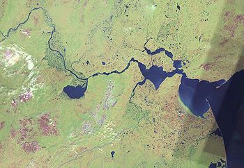 The settlement is located on the northern shores of the Anardyrsky Liman where the waters of the Anadyr
, Kanchalan
and Velikaya
meet creating an estuary. It is located on the northern side of the isthmus, a few miles north west of Ugolnye Kopi
and across the water from Anadyr (town)
, where the three main parts of the estuary, the northern series of lakes, the southern lake and the big lagoon on the east join.
The settlement is served by Ugolny Airport
.
as the administrative centre of the district until 1997 when the centre was finally fixed at Ugolnye Kopi.
Urban-type settlement
Urban-type settlement ; , selyshche mis'koho typu ) is an official designation for a type of locality used in some of the countries of the former Soviet Union...
in Anadyrsky District
Anadyrsky District
Anadyrsky District is an administrative and municipal district , one of the six in Chukotka Autonomous Okrug, Russia. It is located in the interior portion of the autonomous okrug and in terms of administrative divisions borders with Chaunsky District in the northwest, Iultinsky District in the...
of Chukotka Autonomous Okrug
Chukotka Autonomous Okrug
Chukotka Autonomous Okrug , or Chukotka , is a federal subject of Russia located in the Russian Far East.Chukotka has a population of 53,824 according to the 2002 Census, and a surface area of . The principal town and the administrative center is Anadyr...
, Russia
Russia
Russia or , officially known as both Russia and the Russian Federation , is a country in northern Eurasia. It is a federal semi-presidential republic, comprising 83 federal subjects...
. As of 2008, it is in the process of being abolished due to it no longer being considered economically viable to continue mining in the area. Population: 328 (2002 Census
Russian Census (2002)
Russian Census of 2002 was the first census of the Russian Federation carried out on October 9 through October 16, 2002. It was carried out by the Russian Federal Service of State Statistics .-Resident population:...
); As a result of the cessation of mining activities, the population of the settlement has continued to decline. By 2005, an environmental impact report prepared for the Kupol Gold Project indicated that the population of Shakhtyorsky had fallen to just 93 people.
Geography
Anadyr River
Anadyr is a river in the far northeast Siberia which flows into Anadyr Bay of the Bering Sea and drains much of the interior of Chukotka Autonomous Okrug. Its basin corresponds to the Anadyrsky District of Chukotka....
, Kanchalan
Kanchalan River
The Kanchalan River is a 426 km long stream in Far East Siberia. It passes through the sparsely populated areas of the Siberian tundra and flows southwards into the Bering Sea at the Gulf of Anadyr through the Anadyrskiy Liman...
and Velikaya
Velikaya River (Chukotka)
The Velikaya River, also known as Bolshaya and Onemen , is a 556 km long river in Chukotka Autonomous Okrug in Russia. It flows North-Eastwards from the Koryak Range through the Anadyrskiy Liman into the Bering Sea at the Gulf of Anadyr. The area of its drainage basin is 31,000 km². Velikaya ...
meet creating an estuary. It is located on the northern side of the isthmus, a few miles north west of Ugolnye Kopi
Ugolnye Kopi
Ugolnye Kopi is an urban-type settlement north west of Anadyr, on the opposite side of the Anadyr River. It is the administrative center of Anadyrsky District of the Chukotka Autonomous Okrug and part of the Far Eastern Federal District of Russia...
and across the water from Anadyr (town)
Anadyr (town)
Anadyr is a port town and the administrative centre of Chukotka Autonomous Okrug, the extreme north-eastern region of Russia. It is at the mouth of the Anadyr River, on the tip of the southern promontory that sticks out into Anadyrskiy Liman...
, where the three main parts of the estuary, the northern series of lakes, the southern lake and the big lagoon on the east join.
The settlement is served by Ugolny Airport
Ugolny Airport
Ugolny Airport is a mixed-use military and civil airfield in Siberia located 11 km east of Anadyr, separated from the town by the waters of Anadyrsky Liman...
.
History
Shakhtyorsky owes its existence to the presence of both coal and fish in the area and because of that it used to be called Kombinat (lit. Industrial Complex) in the 1950s and 1960s and was the site of the first airport in the District which was constructed in 1930. The settlement used to alternate with Ugolnye KopiUgolnye Kopi
Ugolnye Kopi is an urban-type settlement north west of Anadyr, on the opposite side of the Anadyr River. It is the administrative center of Anadyrsky District of the Chukotka Autonomous Okrug and part of the Far Eastern Federal District of Russia...
as the administrative centre of the district until 1997 when the centre was finally fixed at Ugolnye Kopi.