
Alley Pond Park
Encyclopedia
Alley Pond Park is the second-largest public park in Queens
, New York
. It occupies 655.294 acres (2,651,883.1 m²), most of it acquired and cleared by the city in 1929, as authorized by a resolution of the New York City Board of Estimate
in 1927. The park is bordered to the east by Douglaston, to the west by Bayside
, to the north by Little Neck Bay
, and to the south by Union Turnpike
. It is run and operated by the New York City Department of Parks and Recreation
.
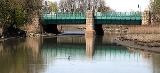
Cross Island Parkway
transects the park from north to south, while the Long Island Expressway and Grand Central Parkway
transect the park from east to west.
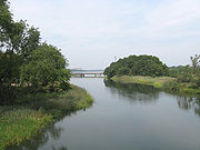
South of the Long Island Expressway, there are woodlands, and north of it, there are meadowlands.
The Alley Pond Environmental Center, with a library, museum and animal exhibits, is located in the northern part of the park, on the south side of Northern Boulevard.
 The park occupies part of a terminal moraine
, a ridge of sand and rock, that was formed by a glacier 15,000 years ago, at the southern terminus of the Laurentide ice sheet
. Boulders dropped by the glaciers on the hillsides of the southern end of the park still remain, as do scattered kettle ponds formed by melting ice. The valley features both fresh water, draining into the valley from the hills and bubbling up from natural springs, and salt water from Little Neck Bay; this promotes ecodiversity, with freshwater and saltwater wetlands, tidal flats, meadows, and forests accommodating abundant bird life. http://www.nycgovparks.org/sub_your_park/historical_signs/hs_historical_sign.php?id=12062
granted Thomas Foster 600 acres (2.4 km²), on which he built a stone cottage near what is now Northern Boulevard. Mill
s were built on Alley Creek by Englishmen Thomas Hicks
and James Hedges, while other colonists used the valley as a route to Brooklyn
, the Hempstead Plains
and the Manhattan
ferries. George Washington
(1732–1799) is thought to have used this route for his 1790 tour of Long Island
. The valley's usage as a passage, or perhaps its shape, may ultimately account for its name; in any case, an 18th century commercial and manufacturing center there became known as "the Alley".
Despite this center and light industrial uses that dated back to Hicks' and Hedges' mills, the area remained agricultural and largely unspoiled into the 20th century. In 1908, as motorists sought attractive areas for expeditions, William Vanderbilt (1849–1920) built his privately run Long Island Motor Parkway
through the area in 1908.
By the 1920s, automobile
s were proliferating faster—and so were people, as the population of Queens doubled during that decade. With open space becoming less plentiful, the City of New York began setting aside land for parks, and it acquired the Alley site for this purpose on June 24, 1929. Later that year, the Parks department expanded the park into 330 newly acquired acres surrounding the alley and removed some older structures. After this acquisition had been approved, MayorJames J. Walker (1881–1946) declared that "there is no better site in Queens".
In 1935, the park officially opened with ceremony attended by Mayor Fiorello H. La Guardia (1882–1947) and Parks Commissioner Robert Moses
(1888–1981). Already, the park boasted 26 acres (105,218.4 m²) of new playing fields; the Alley Pond Park Nature Trail, which was the city's first of its kind; a 23 acres (93,077.8 m²) bird sanctuary; bridle paths; tennis court; picnic areas; and a 200-space parking lot.
The Parks Department added a 2.5 mile (4 km) bicycle path in 1937, having acquired and converted Vanderbilt's parkway. It runs west into Cunningham Park
as part of the 40 mile (65 km) Brooklyn-Queens Greenway
from Bayside
to Prospect Park
and Coney Island
.
Throughout the 1930s, the Parks Department, as it now recognizes on its website, acted with more "zeal" for recreation than for conservation, which was the other purpose of parks. http://www.nycgovparks.org/sub_your_park/historical_signs/hs_historical_sign.php?id=12062 The Department filled in much of the Valley's marsh lands to construct recreational facilities and roads, namely, the Long Island Expressway and Cross Island Parkway. By 1974, the Department and City had begun to make the environment a higher priority, creating the Wetlands Reclamation Project to rehabilitate the park's natural wetlands. In 1976, the Alley Pond Environmental Center opened with a mission of educational and ecological education. For conservation purposes, the City acquired over $10.9 million worth of new land for the park, and in 1993, almost $1 million was spent to restore the Picnic Grove, renovate two stone buildings, and reconstruct the playground and soccer field.
Queens
Queens is the easternmost of the five boroughs of New York City. The largest borough in area and the second-largest in population, it is coextensive with Queens County, an administrative division of New York state, in the United States....
, New York
New York
New York is a state in the Northeastern region of the United States. It is the nation's third most populous state. New York is bordered by New Jersey and Pennsylvania to the south, and by Connecticut, Massachusetts and Vermont to the east...
. It occupies 655.294 acres (2,651,883.1 m²), most of it acquired and cleared by the city in 1929, as authorized by a resolution of the New York City Board of Estimate
New York City Board of Estimate
The New York City Board of Estimate was a governmental body in New York City, responsible for budget and land-use decisions. Under the charter of the newly amalgamated City of Greater New York the Board of Estimate and Apportionment was composed of eight ex officio members: the Mayor of New York...
in 1927. The park is bordered to the east by Douglaston, to the west by Bayside
Bayside, Queens
Bayside is a suburban neighborhood in the borough of Queens in New York, New York in the United States. Bayside is known as one of the most expensive areas to live in Queens, with well kept homes and landscaping...
, to the north by Little Neck Bay
Little Neck Bay
Little Neck Bay is an embayment in western Long Island, New York, off Long Island Sound. Little Neck Bay forms the western boundary of the Great Neck Peninsula, the eastern boundary of which is Manhasset Bay. The political boundary between Nassau County and the borough of Queens runs through the bay...
, and to the south by Union Turnpike
Union Turnpike (New York)
Union Turnpike is a thoroughfare stretching across central and eastern Queens in New York City. It runs from Myrtle Avenue in Glendale to Marcus Avenue in North New Hyde Park, about a mile into Nassau County, New York. Initially designed as a toll road, it takes a straight-arrow path from Kew...
. It is run and operated by the New York City Department of Parks and Recreation
New York City Department of Parks and Recreation
The City of New York Department of Parks & Recreation is the department of government of the City of New York responsible for maintaining the city's parks system, preserving and maintaining the ecological diversity of the city's natural areas, and furnishing recreational opportunities for city's...
.
Cross Island Parkway
Cross Island Parkway
Cross Island Parkway, also known as the 100th Infantry Division Parkway, is a parkway within New York State. The parkway is a part of the Belt Parkway system that runs along the perimeter of the borough of Queens in New York City...
transects the park from north to south, while the Long Island Expressway and Grand Central Parkway
Grand Central Parkway
The Grand Central Parkway is a parkway that stretches from the RFK-Triborough Bridge in New York City to Nassau County on Long Island. At the Queens-Nassau border, it becomes the Northern State Parkway, which runs across the northern part of Long Island through Nassau County and into Suffolk...
transect the park from east to west.
South of the Long Island Expressway, there are woodlands, and north of it, there are meadowlands.
The Alley Pond Environmental Center, with a library, museum and animal exhibits, is located in the northern part of the park, on the south side of Northern Boulevard.
Geology and Ecology
Terminal moraine
A terminal moraine, also called end moraine, is a moraine that forms at the end of the glacier called the snout.Terminal moraines mark the maximum advance of the glacier. An end moraine is at the present boundary of the glacier....
, a ridge of sand and rock, that was formed by a glacier 15,000 years ago, at the southern terminus of the Laurentide ice sheet
Laurentide ice sheet
The Laurentide Ice Sheet was a massive sheet of ice that covered hundreds of thousands of square miles, including most of Canada and a large portion of the northern United States, multiple times during Quaternary glacial epochs. It last covered most of northern North America between c. 95,000 and...
. Boulders dropped by the glaciers on the hillsides of the southern end of the park still remain, as do scattered kettle ponds formed by melting ice. The valley features both fresh water, draining into the valley from the hills and bubbling up from natural springs, and salt water from Little Neck Bay; this promotes ecodiversity, with freshwater and saltwater wetlands, tidal flats, meadows, and forests accommodating abundant bird life. http://www.nycgovparks.org/sub_your_park/historical_signs/hs_historical_sign.php?id=12062
History
What is now Alley Pond Park was once home to the Matinecock, who harvested shellfish from Little Neck Bay. The English began to colonize the area by the 1630s, when Charles ICharles I of England
Charles I was King of England, King of Scotland, and King of Ireland from 27 March 1625 until his execution in 1649. Charles engaged in a struggle for power with the Parliament of England, attempting to obtain royal revenue whilst Parliament sought to curb his Royal prerogative which Charles...
granted Thomas Foster 600 acres (2.4 km²), on which he built a stone cottage near what is now Northern Boulevard. Mill
Watermill
A watermill is a structure that uses a water wheel or turbine to drive a mechanical process such as flour, lumber or textile production, or metal shaping .- History :...
s were built on Alley Creek by Englishmen Thomas Hicks
Thomas Hicks
Thomas Hicks or Tom Hicks may refer to:*Thomas Hicks , American bobsledder who won a bronze medal at the 1948 Winter Olympics...
and James Hedges, while other colonists used the valley as a route to Brooklyn
Brooklyn
Brooklyn is the most populous of New York City's five boroughs, with nearly 2.6 million residents, and the second-largest in area. Since 1896, Brooklyn has had the same boundaries as Kings County, which is now the most populous county in New York State and the second-most densely populated...
, the Hempstead Plains
Hempstead Plains
The Hempstead Plains is a region of central Long Island in New York state in what is now Nassau County. It was once an open expanse of native grassland estimated to once extend to about . It was separated from the North Shore of Long Island by the Harbor Hill Moraine, later approximately the route...
and the Manhattan
Manhattan
Manhattan is the oldest and the most densely populated of the five boroughs of New York City. Located primarily on the island of Manhattan at the mouth of the Hudson River, the boundaries of the borough are identical to those of New York County, an original county of the state of New York...
ferries. George Washington
George Washington
George Washington was the dominant military and political leader of the new United States of America from 1775 to 1799. He led the American victory over Great Britain in the American Revolutionary War as commander-in-chief of the Continental Army from 1775 to 1783, and presided over the writing of...
(1732–1799) is thought to have used this route for his 1790 tour of Long Island
Long Island
Long Island is an island located in the southeast part of the U.S. state of New York, just east of Manhattan. Stretching northeast into the Atlantic Ocean, Long Island contains four counties, two of which are boroughs of New York City , and two of which are mainly suburban...
. The valley's usage as a passage, or perhaps its shape, may ultimately account for its name; in any case, an 18th century commercial and manufacturing center there became known as "the Alley".
Despite this center and light industrial uses that dated back to Hicks' and Hedges' mills, the area remained agricultural and largely unspoiled into the 20th century. In 1908, as motorists sought attractive areas for expeditions, William Vanderbilt (1849–1920) built his privately run Long Island Motor Parkway
Long Island Motor Parkway
The Long Island Motor Parkway , also known as the Vanderbilt Parkway and Motor Parkway, was the first roadway designed for automobile use only. It was privately built by William Kissam Vanderbilt with overpasses and bridges to remove intersections...
through the area in 1908.
By the 1920s, automobile
Automobile
An automobile, autocar, motor car or car is a wheeled motor vehicle used for transporting passengers, which also carries its own engine or motor...
s were proliferating faster—and so were people, as the population of Queens doubled during that decade. With open space becoming less plentiful, the City of New York began setting aside land for parks, and it acquired the Alley site for this purpose on June 24, 1929. Later that year, the Parks department expanded the park into 330 newly acquired acres surrounding the alley and removed some older structures. After this acquisition had been approved, MayorJames J. Walker (1881–1946) declared that "there is no better site in Queens".
In 1935, the park officially opened with ceremony attended by Mayor Fiorello H. La Guardia (1882–1947) and Parks Commissioner Robert Moses
Robert Moses
Robert Moses was the "master builder" of mid-20th century New York City, Long Island, Rockland County, and Westchester County, New York. As the shaper of a modern city, he is sometimes compared to Baron Haussmann of Second Empire Paris, and is one of the most polarizing figures in the history of...
(1888–1981). Already, the park boasted 26 acres (105,218.4 m²) of new playing fields; the Alley Pond Park Nature Trail, which was the city's first of its kind; a 23 acres (93,077.8 m²) bird sanctuary; bridle paths; tennis court; picnic areas; and a 200-space parking lot.
The Parks Department added a 2.5 mile (4 km) bicycle path in 1937, having acquired and converted Vanderbilt's parkway. It runs west into Cunningham Park
Cunningham Park
Cunningham Park is a park in the New York City borough of Queens. The park lies between the Grand Central Parkway to the south and the Long Island Expressway, and is bifurcated by the Clearview Expressway...
as part of the 40 mile (65 km) Brooklyn-Queens Greenway
Brooklyn-Queens Greenway
The Brooklyn-Queens Greenway is a bicycling and pedestrian path connecting parks and roads in the New York City boroughs of Brooklyn and Queens, connecting Coney Island in the south to Fort Totten in the north, on Long Island Sound...
from Bayside
Bayside, Queens
Bayside is a suburban neighborhood in the borough of Queens in New York, New York in the United States. Bayside is known as one of the most expensive areas to live in Queens, with well kept homes and landscaping...
to Prospect Park
Prospect Park (Brooklyn)
Prospect Park is a 585-acre public park in the New York City borough of Brooklyn located between Park Slope, Prospect-Lefferts Gardens, Kensington, Windsor Terrace and Flatbush Avenue, Grand Army Plaza and the Brooklyn Botanic Garden...
and Coney Island
Coney Island
Coney Island is a peninsula and beach on the Atlantic Ocean in southern Brooklyn, New York, United States. The site was formerly an outer barrier island, but became partially connected to the mainland by landfill....
.
Throughout the 1930s, the Parks Department, as it now recognizes on its website, acted with more "zeal" for recreation than for conservation, which was the other purpose of parks. http://www.nycgovparks.org/sub_your_park/historical_signs/hs_historical_sign.php?id=12062 The Department filled in much of the Valley's marsh lands to construct recreational facilities and roads, namely, the Long Island Expressway and Cross Island Parkway. By 1974, the Department and City had begun to make the environment a higher priority, creating the Wetlands Reclamation Project to rehabilitate the park's natural wetlands. In 1976, the Alley Pond Environmental Center opened with a mission of educational and ecological education. For conservation purposes, the City acquired over $10.9 million worth of new land for the park, and in 1993, almost $1 million was spent to restore the Picnic Grove, renovate two stone buildings, and reconstruct the playground and soccer field.
External links
- Alley Pond Park, New York City Department of Parks and RecreationNew York City Department of Parks and RecreationThe City of New York Department of Parks & Recreation is the department of government of the City of New York responsible for maintaining the city's parks system, preserving and maintaining the ecological diversity of the city's natural areas, and furnishing recreational opportunities for city's...
- Alley Pond Environmental Center