

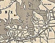
Little Neck Bay
Encyclopedia
Bay
A bay is an area of water mostly surrounded by land. Bays generally have calmer waters than the surrounding sea, due to the surrounding land blocking some waves and often reducing winds. Bays also exist as an inlet in a lake or pond. A large bay may be called a gulf, a sea, a sound, or a bight...
in western Long Island
Long Island
Long Island is an island located in the southeast part of the U.S. state of New York, just east of Manhattan. Stretching northeast into the Atlantic Ocean, Long Island contains four counties, two of which are boroughs of New York City , and two of which are mainly suburban...
, New York
New York
New York is a state in the Northeastern region of the United States. It is the nation's third most populous state. New York is bordered by New Jersey and Pennsylvania to the south, and by Connecticut, Massachusetts and Vermont to the east...
, off Long Island Sound
Long Island Sound
Long Island Sound is an estuary of the Atlantic Ocean, located in the United States between Connecticut to the north and Long Island, New York to the south. The mouth of the Connecticut River at Old Saybrook, Connecticut, empties into the sound. On its western end the sound is bounded by the Bronx...
. Little Neck Bay forms the western boundary of the Great Neck Peninsula
Great Neck, New York
The term Great Neck is commonly applied to a peninsula on the North Shore of Long Island, which includes the village of Great Neck, the village of Great Neck Estates, the village of Great Neck Plaza, and others, as well as an area south of the peninsula near Lake Success and the border of Queens...
, the eastern boundary of which is Manhasset Bay
Manhasset Bay
Manhasset Bay, New York, is an embayment in western Long Island off Long Island Sound. Manhasset Bay forms the northeastern boundary of the Great Neck Peninsula and the southwestern boundary of Cow Neck...
. The political boundary between Nassau County and the borough
Borough (New York City)
New York City, one of the largest cities in the world, is composed of five boroughs. Each borough now has the same boundaries as the county it is in. County governments were dissolved when the city consolidated in 1898, along with all city, town, and village governments within each county...
of Queens
Queens
Queens is the easternmost of the five boroughs of New York City. The largest borough in area and the second-largest in population, it is coextensive with Queens County, an administrative division of New York state, in the United States....
runs through the bay. At the entrance to the bay, on the western point (known as Willet's Point) is Fort Totten built to protect the entrance to the tidal strait known as the East River
East River
The East River is a tidal strait in New York City. It connects Upper New York Bay on its south end to Long Island Sound on its north end. It separates Long Island from the island of Manhattan and the Bronx on the North American mainland...
.
At the eastern side of the entrance is Elm Point (the end of Steamboat Road in King's Point
Kings Point, New York
Kings Point is a village and a part of Great Neck in Nassau County, New York on the North Shore of Long Island. As of the United States 2010 Census, the village population was 5,005.The Village of Kings Point is in the Town of North Hempstead...
). The bay is about a mile wide at the entrance and extends back just under two miles. Originally, on the western and southern sides of the bay there were extensive salt marshes. Saddle Rock is located on the eastern side of the bay about half-way in. The bay is shallower than Manhasset Bay, being only 12 feet (3.7 m) deep at the entrance, with most of the back bay being less than 6 feet (1.8 m) deep. Alley Pond Park
Alley Pond Park
Alley Pond Park is the second-largest public park in Queens, New York. It occupies , most of it acquired and cleared by the city in 1929, as authorized by a resolution of the New York City Board of Estimate in 1927. The park is bordered to the east by Douglaston, to the west by Bayside, to the...
and Cross Island Parkway
Cross Island Parkway
Cross Island Parkway, also known as the 100th Infantry Division Parkway, is a parkway within New York State. The parkway is a part of the Belt Parkway system that runs along the perimeter of the borough of Queens in New York City...
are on the southern and southwestern shore, and Alley Creek drains into the bay.
History
Traditionally, the AlgonquinAlgonquian peoples
The Algonquian are one of the most populous and widespread North American native language groups, with tribes originally numbering in the hundreds. Today hundreds of thousands of individuals identify with various Algonquian peoples...
who lived around Little Neck Bay when Europe
Europe
Europe is, by convention, one of the world's seven continents. Comprising the westernmost peninsula of Eurasia, Europe is generally 'divided' from Asia to its east by the watershed divides of the Ural and Caucasus Mountains, the Ural River, the Caspian and Black Seas, and the waterways connecting...
ans came were considered to be from a tribe known as the Matinecock
Metoac
Metoac is the collective name for the group of culturally and linguistically related Native American settlements roughly east of what is now the Nassau County line on, Long Island in New York at the time of European contact in the 17th century. Metoac does not specifically refer to political,...
. However, that view has been challenged.
From the 1860s through the 1890s, small hard clam
Hard clam
The hard clam , also known as a quahog , round clam, or hard-shell clam, is an edible marine bivalve mollusk which is native to the eastern shores of North America, from Prince Edward Island to the Yucatán Peninsula...
s (quahogs) from Little Neck Bay were served in the best restaurants of New York and several European capitals. Eventually, the term "littleneck" or "littleneck clam" came to be used as a size category for all hard clams, regardless of origin. Saddle-rock oysters are also found in the bay. The bay was closed to harvesting in 1909 due to pollution.
External links
- Mimoni, Victor A thorough history of Little Neck/Douglaston Queens Courier (26 February 2008).